

Introduction
The Wrangell–St Elias Mountains form a major orographic barrier to storms in the North Pacific. These mountains range in height from 3–6km and store most of the precipitation as snow and glacier ice. The annual precipitation on the seaward side is in the range of 3–5m of water, while on the lee side it is about 20 times less.
The western Wrangell Mountains are ice-covered volcanoes; their continuous mantle of glacier ice exceeds 5000 km2 in area, approximately 62% of the area covered by the Vatnajökull ice cap in Iceland. They are among the highest mountains in North America and, by volume, some of the largest in the world (Reference Richter, Rosenkrans and SteigerwaldRichter and others, 1995). Tectonically, they are located between the Pacific subduction zone on the south and the Denali strike slip fault system on the north (Fig. 1). Mt Wrangell (62.008 N, 144.028 W; 4317 m a.s.l.) is the youngest of these Tertiary to Quaternary volcanoes and the only one to remain active today. It is a massive shield volcano of immense bulk (1000km3) with an area of more than 35 km2 above the 4000 m altitude (Fig. 1). The mountain is completely covered by glacier ice at altitudes above 2000 m with some glaciers extending below 1500 m. Its summit is dominated by the ice-filled, 4 ×6km Summit Caldera, with three post-caldera Holocene craters on the caldera rim (Fig. 2). Glaciologically, its summit region is in the dry-snow facies (Reference BensonBenson, 1961), so negligible summer melting occurs. The mean annual temperature, measured 10m below the snow surface, is –208C, and the annual accumulation rate is 1–2m of water equivalent. Glacier ice drains out of the Summit Caldera through Long Glacier and a much smaller outlet on the northeast rim (Fig. 2). Ice depth is probably more than 900 m, but a definite bottom has not been obtained by radio-echo sounding (Reference MotykaMotyka, 1983; Reference Clarke, Cross and BensonClarke and others, 1989). Seismic soundings also failed to give a definitive bottom (Reference Lüthi, Solie, Truffer and BensonLüthi and others, 2005). The radio-echo soundings show strong internal reflections. Mt Wrangell is similar to the ice-covered, and more active, Ushkovsky Volcano (568 N, 1608 E; 3900m a.s.l.) which is a compound volcano on Russia’s Kamchatka Peninsula. Comparisons between ice cores from Mt Wrangell’s Summit Caldera (Reference Shiraiwa, Kanamori, Benson, Solie and MuravyevShiraiwa and others, 2004) and from Gorshkov Crater at the summit of Mt Ushkovsky are underway (Reference ShiraiwaShiraiwa and others, 2001).
The first aerial photograph of Mt Wrangell (4317 m) from the south, with Mt Sanford (4950 m) in the background, taken by the US Air Force for the USGS in 1948. The West Crater was the active crater at that time. The star on the inset map shows the location of Mt Wrangell. The line curving to the northwest of Mt Wrangell represents the Denali Fault, dots at the west end show the locations of the 2002 Mw = 7.9 earthquake and its Mw = 6.7 foreshock. The line labeled ‘Aleutian Trench’ locates the subduction zone where the Pacific Plate thrusts under the American Plate.

Summit Caldera of Mt Wrangell with survey control points marked (photograph by AERO-METRIC, 22 August 1975). The boundary drawn around the North Crater indicates the area covered by the photogrammetric topographic maps, scale of 1:2000 with 5 m contour intervals.

Mt Wrangell’s eruptive history is sketchy and incomplete. Some of it is based on newspaper accounts and anecdotes. It includes sightings of ‘lava flows’, but there is no confirmation of flowing lava recently. The most recent lava flows, based on radiometric K-Ar dating, are at least 50 000 years old (Reference Richter, Rosenkrans and SteigerwaldRichter and others, 1995). Two early reports (Reference PowellPowell, 1900; Reference RiceRice, 1900) described eruptive activity on Mt Wrangell that occurred shortly after the 10 September 1899, M = 8.6 (Richter magnitude) earthquake in Yakutat Bay, Alaska. In historical time, Mt Wrangell’s activity has consisted solely of vigorous fumarolic venting and phreatic eruptions from craters on the rim of the Summit Caldera.
The heat flux at the summit of Mt Wrangell began to change following the Mw = 9.2 (moment magnitude) Great Alaskan Earthquake of 27 March 1964. These changes were first noted in 1965–66 while continuing our glacier research, which began at the summit in 1961. The research included snow pit and core measurements in the craters and in the Summit Caldera, measurements of heat flux on the ice-free ridges, changes in the glacier ice volume in the craters measured by aerial photogrammetry, several measurements of water and gas chemistry, depth soundings in the Summit Caldera and temporary meteorological and seismic measurements. This paper focuses on changes that have occurred over the past half-century within the North Crater on the rim of the Summit Caldera, with some reference to changes in the adjacent West Crater and Summit Caldera. The data on changes in glacier ice volume in the North Crater are published here in complete form for the first time.
Observations and Data
The summit region
The first aerial photograph of Mt Wrangell was taken in 1948. It showed complete snow cover except for the West Crater and parts of the East Crater (Fig. 1) and the summit ridge extending away from the East Crater (Fig. 2). The West Crater was identified as ‘Wrangell Crater’ on United States Geological Survey (USGS) maps. However, the terminology used in this paper is the modern convention (Reference Richter, Rosenkrans and SteigerwaldRichter and others, 1995). This appearance of the summit region in 1948 was the same as described and photographed on the surface in 1908 (Reference DunnDunn, 1909). Although there were no observations of the summit in the years between 1908 and 1948, essentially the same conditions were observed in 1953 and 1954 by researchers from the University of Alaska and New York University as they tried to measure cosmic rays at the summit (Reference BeiserBeiser, 1953). We began glaciological research and measurements of ash temperatures on snow-free ridges in 1961. Conditions in 1961–62 were found to be the same as in 1953–54, but in 1965–66 we began to observe significant changes in volcanic heat flux, especially in the West and North Craters.
Glaciology and temperature measurements on snow-free ridges
The original goal of the glaciological research was to find a site in Alaska with a large area of dry snow facies (Reference BensonBenson, 1961, Reference Benson1962a, Reference Bensonb). Benson selected the summit of Mt Wrangell based on recommendations by Dr Terris Moore and other members of the 1953–54 expeditions and because it was accessible by ski-equipped aircraft. Snow pits to depths of 4 m, with cores extending to 10 m, were used to determine annual accumulation of about 1 m of water equivalent in the North Crater but substantially more (up to 1.5–2 m) in the Summit Caldera. The mean annual temperature in the North Crater and in the Summit Caldera, measured 10 m below the snow surface, was –208C (Reference WhartonWharton, 1966; Reference BensonBenson, 1968). The summit proved to be in the dry snow facies with negligible summer melting (Reference Benson, Motyka, Bingham, Wharton, MacKeith, Sturm, Kotlyakov, Vinogradov and GlazovskiyBenson and others, 1985).
The ash on snow-free ridges in 1961 was unfrozen and temperatures ranged from 08C to 108C at the surface to +308C at a depth of 1 m. Heat flow measurements indicated that a geothermally heated hut was feasible; one was designed and built in 1964 (Reference Bingham and BensonBingham and Benson, 1968) on the south rim of the North Crater, next to survey point 2 (Fig. 2). In 1965 and 1966 ash temperatures were significantly higher and approached the 600mb boiling point, 868C, at depths of less than 1 m. The higher temperatures persisted and large areas of the North Crater’s rim became exposed (Reference WendlerWendler, 1967).
In 1965–66 the horizontal component of glacier flow in the Summit Caldera was of the order 10ma–1 with the downward vertical component being slightly less; in the North Crater the flow vectors were an order of magnitude less with the vertical components twice the horizontal components. Flow was directed toward the crater walls (Reference BinghamBingham, 1967). The only exit for glacier ice from the North Crater was into the Summit Caldera with a surface flow in the range of 3–4ma–1 at the crater rim. However, the volcanic heat on ridges of the North Crater began increasing noticeably between 1965 and 1966 and continued to increase thereafter. No observations were possible in 1967, but an overflight in July 1968, to observe and take oblique photographs with a 35mm camera, showed most of the glacier ice along the south and southeast rim had melted. Ice no longer flowed out of the North Crater and the outer wall of its south rim was a jumble of ice blocks where ice once flowed into the Summit Caldera.
Onset of changes in heat flux
The volcanically heated hut, which served well in 1964, 1965 and 1966, was no longer useable when we returned to the North Crater for a ground reconnaissance in 1972; temperatures inside were too high and several fumaroles perforated the floor. Subsurface temperature measurements in 1965 indicated the boiling point of 868C was closer to the ground surface than it had been in 1961. The area of bare ground increased between the summers of 1964 and 1965 with a more prominent increase occurring between 1965 and 1966. Before March 1966, no vegetation had been observed along the North Crater’s hut ridge (between survey points 2 and 3; Fig. 2). However in 1966, algae were present on the ridge in areas that were at or close to the boiling point (Reference BinghamBingham, 1967). In August 1966, a heat flux of 52 Wm–2 was measured from basal melt rates of glacier ice flowing over the southern rim (Reference BinghamBingham, 1967). A comparison of oblique photos taken in 1954 by C.R. Wilson and in 1966 by
D.K. Bingham indicates that the ice had thinned there by 5–15 m. In August 1966 a lake of about 40 m diameter was present at the bottom of the West Crater (Reference BinghamBingham, 1967; Reference MotykaMotyka, 1983). This corresponds to the time when large increases in heat flow were first observed in the North Crater. The lake was gone by July 1968 when J. Wilson made an overflight to take photographs. However, in the North Crater the increased heat flux persisted, with fluctuations, to the present. The extent of ice loss in the North Crater is illustrated in Figures 3a and 3b, which show the North Crater from the rim of the West Crater (point no. 7 of Fig. 2) in 1965 and 1976 respectively. The loss of glacier ice was restricted to the North Crater, while snow and ice accumulated simultaneously in theWest Crater. The surface of the Summit Caldera was lowered by about 5 m within 0.5 km of the North Crater rim, but at distances of more than 1 km from the North Crater the surface altitude in the Summit Caldera remained essentially unchanged (Reference MotykaMotyka, 1983; Reference Benson and FollettBenson, 1986).
Views of the North Crater from survey point 7: (a) in 1965 (photograph by George Wharton) and (b) in 1976 (photograph by Carl Benson).

Aerial photogrammetry
The only feasible way to measure the change of glacier ice volume in the entire North Crater was by photogrammetry. Figure 4 shows examples of the vertical aerial photos and reveals changes in the North Crater from 1957 to 1976. The 1957 photo shows the large crevasse formed at the crater rim as glacier ice flowed from the North Crater into the Summit Caldera before 1968. For a good view of this flow, photographed from the middle of the Summit Caldera in 1961, see Reference BensonBenson (1968, Fig. 14). Photogrammetric topographic maps, at a scale of 1:2000 with 5 m contour intervals, were made from stereo pairs of vertical photos, such as those in Figure 4. The boundary showing the area covered by these maps is drawn on Figure 2. Reference BensonBenson and Follett (1986) published the 1957 and 1983 maps.
Vertical photographs of the North Crater showing the changes which first became apparent in 1965. The dimension across the bottom of each photo is 1.9 km (see Fig. 2).

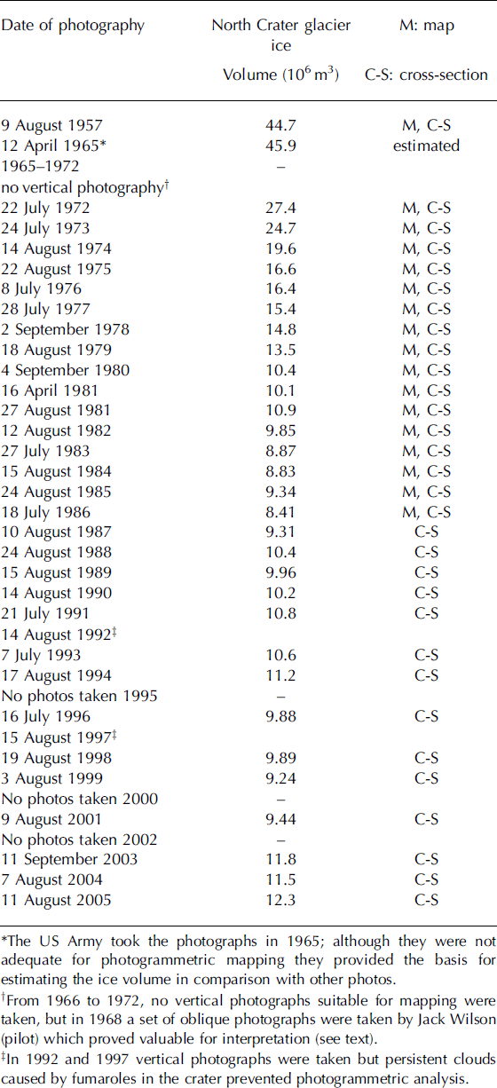
In addition to making maps of the North Crater, photogrammetric cross-sections were made at 20 m intervals across it. Maps and cross-sections were made for most of the years from 1972 to 1986; after 1986 we made cross-sections only. Table 1 lists the dates of photography and indicates the years in which maps and/or cross-sections were made. We began serious use of aerial photogrammetry in 1972 by contracting to have the vertical aerial photos taken and the analyses done. We obtained the original USGS photos from 1957, transferred our ground control points to them, and made a photogrammetric map as well as a set of cross-sections. An incomplete set of photos made for us by the US Army in 1965 was not adequate for photogrammetric analysis but allowed us to make useful comparisons with the complete photo sets from 1957 and 1972. Following 1966, several flights with light aircraft and one brief field trip were all we could do until 1975. Since then, we have continued intermittently with field studies and nearly continuously with aerial photogrammetry from 1972 to the present.
Survey points on the North Crater rim were marked for use as ground control points for the photogrammetric analyses. The survey control points were established by Reference BensonBenson in 1961, refined by Reference BinghamBingham (1967) and made more precise by using electronic distance measuring equipment in 1975–76 (Reference MotykaMotyka, 1983). The survey points are located to ±0.03m within the network of points. However, the network itself is not tied to any benchmark points established by the USGS. The nearest of these points is more than 50 km away.
Mount Wrangell photogrammetry parameters and calculated glacier ice volumes
The spacing of the cross-sections, which extend from rim to rim of the crater, and the definition of the coordinate axes, with survey point 2 as the origin, are shown in Figure 5. The positive X-axis is roughly oriented to the East. A set of cross-sections along the line Y = 1000 shown in Figure 6 illustrates the lowering of the snow surface from 1957 to 1980. In 1979 the flat bottom indicates a water surface. The North Crater is a double crater with the youngest and most active part on the east side. Notches in cross-sections of 1972, 1973 and 1975 indicate crevasses between the two parts of the North Crater.
Photogrammetric cross-sections were made at 20 m intervals along the Y-axis using the coordinates as shown. The positive X-axis is approximately east with the Y-axis normal to it. For simplicity, the exact spacing of the lines is shown in detail only for lines Y = 900– 1000; the actual cross-sections extend from rim to rim of the crater (photograph by AERO-METRIC, 15 August 1984).

Selected profiles of the snow surface along line Y = 1000 of Figure 5. The bottom of the North Crater was estimated from photographs with large amounts of bare ground. In 1979 the flat bottom was a lake surface.

Accuracy of the photogrammetrically-defined snow surfaces was tested by precisely locating a set of stakes and providing the photogrammetrist with X and Y data but not Z (altitude) coordinates. During construction of the map, these X-Y coordinates were revisited (the stakes were not visible on the aerial photographs) ten times to measure the Z coordinates. For each point, these ten determinations averaged within 0.5–1.0m of the true altitude determined by precision surveying. Since the altitude of the snow surface decreased by about 5 m per year between 1972 and 1980, we determined that photogrammetry was an adequate tool for our measurements (Reference MotykaMotyka, 1983; Reference Benson and FollettBenson and Follett, 1986). For bare ground surfaces or lake surfaces in the North Crater, the photogrammetrist estimated the accuracy to be ±0.2m (personal communication from A.B. Follett, 1975).
In 1981, we had a fortuitous situation that allowed us to measure accumulation by using photogrammetry over the North Crater. It is the only year for which we have two sets of complete photos: one for April and one for August (Table 1). We obtained the April data during a special photo flight made to investigate a major landslide on nearby Mt Sanford, which occurred on 11 April. Comparing April to August, the photogrammetric difference in volume was 8.1×10⁵m3 (Table 1). If we assume the volume to be evenly distributed over the crater’s area of 5.2×10⁵m2, the additional thickness of snow was 1.56 m. This is a minimum as there was some loss by bottom melting.
The calculated volume of glacier ice in the North Crater as a function of time is shown in Figure 7, together with the dates and moment magnitudes (Mw) of major earthquakes with epicenters within 250 km of Mt Wrangell. The volume calculation was carried out as follows.
Glacier ice volume in the North Crater determined photogrammetrically; each data point represents about 10 000 data pairs of X and Z values. The dots have diameters of 1×10⁶m3, which serve as error bars, except for the 1965 point: it is an estimate (see text). The dates and magnitudes of major earthquakes with epicenters within 250 km of Mt Wrangell are also shown.

The boundary of the North Crater was defined and about 200 data points were used to calculate the area of each cross-section between the snow surface and an arbitrary altitude of 3900 m which lies beneath the crater’s bottom. A 20m width was applied to each cross-section to obtain a volume element from the surface to a plane at 3900 m. The total of 45 cross-sections, using about 10 000 data points per year, provided the total volume. Since the photogrammetric error in determining the surface is of the order 0.5–1.0m over the crater area of 5.16×10⁵m2, the volume error is 0.26–0.52×10⁶m3. Except for 1965, the diameter of the dots in Figure 7 is 1×10⁶m3 so their vertical dimensions serve as worst-case error bars for the plotted values of volume. The rock volume below the ice-rock contact down to 3900m was estimated and subtracted from the total volume from the snow surface to 3900m to obtain the net glacier ice volumes plotted in Figure 7. The rock volume estimate included creating a bottom cross-section for each of the 45 cross-sections by examining photos in which bare walls and sections of the bottom were visible.
Glacier calorimetry
To determine the heat flux associated with ice melt rates, Reference MotykaMotyka (1983) applied ‘glacier calorimetry’. The western (older) part of the crater did not lose its ice cover and basal melt rates were calculated from the decrease in glacier thickness combined with information on accumulation and estimates of conductive heat losses. The calorimetric analysis is simpler than in the Icelandic case, because no melting occurs by atmospheric processes (Reference Björnsson and GuðmundssonBjörnsson and Guðmundsson, 1993). The rate of change of the surface elevation was determined from photogrammetry. A correction was then applied to adjust for snow compaction. A depth-density curve based on accumulation cores was then used to estimate ice density at the ground-ice interface. The heat needed to melt the water equivalent ice loss was then calculated. Additional calculations were made to estimate conductive heat losses through the snow and ice to the atmosphere. The results showed that the annual average of basal melt rates in ice-covered parts of the crater varied between 2m and 10m water equivalent, giving heat flux values of 20–140Wm–2. This agrees well with the direct measurement of 52Wm–2 made by Reference BinghamBingham (1967).
In an attempt to estimate the total heat loss from the North Crater, powerful fumaroles proved to be the most difficult to estimate. Nevertheless, they were responsible for 60% of the ice loss and melted all of the ice in the most active (eastern) parts of the crater, leaving bare ground and occasional lakes. The tool of glacier calorimetry was lost in these areas. In addition to glacier calorimetry, temperature measurements were made in the sand and ash along the bare ridges, with some direct measurements on large active fumaroles, and estimates of heat loss from lake surfaces when they were present. The total estimate for heat loss from the North Crater varied within the range 20–100MW (Reference MotykaMotyka, 1983), which is 2 orders of magnitude less than the peak values under the subglacial Grimsvötn Caldera (Reference Björnsson and GuðmundssonBjörnsson and Guðmundsson, 1993). On the other hand it is two orders of magnitude higher than heat flux measured at the bottom of Gorshkov Crater at the summit of Mt Ushkovsky on Kamchatka Peninsula (Reference ShiraiwaShiraiwa and others, 2001).
Seismicity
Local seismic activity, measured on the rim of the North Crater with a portable seismograph during the field seasons of 1975, 1976 and 1980, proved useful in identifying the weak subduction zone under the Wrangell Mountains (Reference Stephens, Fogleman, Lahr and PageStephens and others, 1984). In 2000 and 2001 a network of four permanent seismic stations (two in 2000 and two more in 2001) was established on Mt Wrangell with one station on the rim of the North Crater near survey point 1 (Figs 2 and 5). These stations send data to the Geophysical Institute by radio and telephone links. The Alaska Volcano Observatory (AVO) reduces data, and yearly catalogs are produced for locatable earthquakes (e.g. Reference Dixon, Stihler, Power, Tytgat, Estes, Prejean, Sanchez, Sanches, McNutt and PaskevitchDixon and others, 2005). These catalogs also show maps of the seismic network (see: http://www.avo.alaska.edu). The Wrangell earthquake depths range from 3 km above sea level (just below the summit) to 15 km below sea level (Fig. 8) and are similar to the depths of earthquakes at other Alaskan volcanoes. The depths and locations are also consistent with the presence of a shallow magma feeding system. Further, the events include both volcano–tectonic (VT) events and generally shallower long-period (LP) events (Fig. 8); the presence of both event types is also consistent with a shallow magma feeding system.
Depth vs time plot for located earthquakes with M ≥0.9 at Mt Wrangell’s seismic network between May 2002 and June 2003. Negative depths correspond to locations above sea level. Squares and circles mark LP (long-period events) and VT (volcano–tectonic events) respectively. The VT events typically occur in swarms and are attributed to slip on faults, whereas the mostly shallower LP events are likely related to fluid processes (modified after Reference Sanchez and McNuttSanchez and McNutt, 2004).

Plot of the number of local earthquakes at the seismic station located on the North Crater rim, near control point 1 in Figures 2 and 5, within a period of ±15 days of the Mw = 7.9 Denali Fault earthquake. The decrease in seismicity rate is statistically significant at the 99% confidence level, as evaluated by the t-test (Reference Sanchez and McNuttSanchez and McNutt, 2004). These data represent smaller magnitude earthquakes than the located earthquakes shown in Figure 8.

The epicenters of all three earthquakes dated on Figure 7 were less than 250 km from Mt Wrangell. The permanent seismic stations on the mountain were only available for the earthquake on 3 November 2002 (Mw = 7.9) located on the Denali Fault. During and after the 2002 earthquake, all four seismic stations functioned continuously, and showed a decrease of 50% in activity (Figs 8 and 9) for 30 days in detected events and about 5 months for larger events that could be located. After March 2003 the seismicity returned to the long-term baseline where it has remained ever since (Reference Sanchez and McNuttSanchez and McNutt, 2004; Reference Dixon, Stihler, Power, Tytgat, Estes, Prejean, Sanchez, Sanches, McNutt and PaskevitchDixon and others, 2005, Reference Dixon, Stihler, Power, Tytgat, Estes and McNutt2006). The 2002 earthquake was a shallow (approximately 15 km) strike slip earthquake, whereas the two previous earthquakes were deep (approximately 40 km) subduction zone earthquakes. The depths, magnitudes, focal mechanisms and locations all affect the dynamic shaking as well as the static strains caused by these earthquakes.
Water and gas chemistry
Several analyses were performed on gases and water collected from fumaroles and acid springs on the floor of the North Crater (Reference MotykaMotyka, 1983). The gas samples showed significant levels of sulphur dioxide (SO2) and halogens but low levels of hydrogen (H2). Based on fluid equilibrium studies, it was surmised that these gases were formed in the temperature range of 600–8008C under oxidizing conditions. These results imply that a shallow body of cooling magma underlies the North Crater, at depths of perhaps no more than one kilometer. In addition, isotopic studies of 13C and 3He/ 4He ratios in the gases confirm magma as the likely source of heat underlying the North Crater (Reference Motyka, Poreda and JeffreyMotyka and others 1989).
Discussion
Observations from the beginning of the 20th century in 1908, to 1948 when the first aerial photo was taken, to field observations in 1953–1954 and to the initiation of our field studies in 1961, showed little change at the summit of Mt Wrangell. However, in 1965–1966 we observed the first indications of significant changes in the distribution of volcanic heat flow. Initially, both the West Crater and the North Crater showed increases, but the West Crater, which had been the active crater, began to cool and by 1968 it was filling with snow. The main activity shifted to the North Crater with increased heat flux, which has persisted with fluctuations to the present. We assume that the concentration of increased heat in the North Crater indicates convective action beneath the crater. It also appears that the two craters are connected at depth with the more recent convective path taking over heat flow that had been going to theWest Crater. The Great Alaskan Earthquake, Mw = 9.2 of 27 March 1964 is the most likely initiator; it was the largest earthquake ever recorded in North America. By shaking the mountain, it likely fractured previously self-sealed, convective channels above a late stage, but still hot magma body.
Reference MotykaMotyka (1983) proposed a model in which water derived from basal melting began to percolate downwards toward the heat source. At first, water in the pore spaces immediately surrounding the heat source boils off and the zone becomes supersaturated with steam. The resulting vapor increases heat flow to the surface causing an accelerated melt rate. Eventually the rate of meltwater influx will exceed the vaporizing capacity of the heat source and effectively quench the vapor phase and reduce the heat flow. Reduction in heat flow reduces both the ice melt rate and the rate of water influx to the deeper system. As the rate of vaporization at depth begins to exceed the rate of meltwater influx, the water pressure will drop. The resulting decrease in boiling point temperature increases the rate of vaporization; this leads to a further reduction in boiling point temperature and leads to a geyser-like accelerated rate of vaporization. The process repeats itself when meltwater again accumulates over the heat source. The model is similar to that used by Reference Hurst, Bibby, Scott and McGuinnessHurst and others (1991) for the heat transfer mechanism beneath the Crater Lake on top of New Zealand’s Ruapehu volcano.
Heat flux was not constant but pulsed with peaks in 1967–68, 1973–74 and following 1979 (Fig. 7). By considering reasonable values for rock fracture, permeability, pressure gradients, depth to the heat source and depth to the water table, Reference MotykaMotyka (1983) accounted for the observed reduction in melt rate between 1975 and 1978 (Fig. 7) as well as the increase after 1979. However, in addition to this model’s explanation of the variability, we have the complication that the Mt St Elias earthquake on 28 February 1979, Mw = 7.5, may have reopened convection channels that were gradually being resealed during the 1975–79 period by deposition of salts. This, too, could have accelerated the melt rate between 1979 and 1980.
To calculate the total volume of water lost from the North Crater, we begin by observing that the total glacier ice volume lost in the North Crater from 1965–84 was 35×106m3 (Fig. 7). If we assume an average density of 700 kgm–3 this yields 24.5×10⁹ kg or 24.5×10⁶m3 (24.5× 10⁻³ km3) of water. If we add the accumulation of 1.5m water equivalent per year added during the 9 year period (1965–84) it becomes 13.5 m over the area of 5.2×10⁵m2 which results in the addition of another 7.0×10⁶m3 (7.0×10⁻³km3) of water. The total of 31.5×10⁻³km3 over a period of 9 years is dwarfed by the release of water volumes of 2–5 km3 in several days every 4–10 years during jökulhlaups from Grimsvötn caldera within the Vatnajökull ice cap (Reference Björnsson and GuðmundssonBjörnsson and Guðmundsson, 1993).
The lakes at the bottom of the North Crater were temporary features that resulted from the generation of meltwater overtaking the processes that removed the water. They were of the order 2–7×10⁴m3; this is two orders of magnitude less than the volume of New Zealand’s Ruapehu crater lake, which ranges from 6–9×10⁶m3. There was evidence of convection in the temporary lakes at the bottom of the North Crater where upwelling water moved icebergs away from ice-free areas. But aside from estimating the heat loss from the lake surfaces, we did no detailed analysis of heat flux in the lakes as was done by Reference Hurst, Bibby, Scott and McGuinnessHurst and others (1991) for the large lake on Ruapehu. Even though it is less than amounts of water associated with other volcanoes, the question arises of what happens to the volume of water lost by ice melting at the top of Mt Wrangell, where the mean annual temperature is –208C. We infer that some of it goes into running the deep convective systems, some drains under outlet glaciers especially on the northeast flank (Reference SturmSturm, 1995) and some is lost by evaporation to produce prominent plumes over the crater.
The amount available for the convection systems may be decreasing. In areas where bare ground is exposed, vigorous fumarole activity continues, but our aerial photos do not show water at the bottom since the last lake was observed in 1998. It may be that an increasing amount of the meltwater is now being lost to the atmosphere in the form of the ever-visible plumes formed by condensing water vapor. In any event, the lower overall availability of meltwater may be part of the reason why the apparent response to the 2002 Denali Fault earthquake appears to be different from the responses to the 1964 and 1979 earthquakes.
Glaciers on the northeast flank of Mt Wrangell have been advancing while the termini of glaciers on the west side have not. This has been documented by examining aerial photos available from 1957, 1977, 1979 and 1981. Orthophoto maps prepared from these photos (Reference BensonBenson and Follett, 1986) and field observations (Reference SturmSturm, 1995) also show anomalously steady flow, daily and seasonally, for glaciers only on the northeast side. We interpret this as evidence of meltwater from the summit leaking under the northeast flank glaciers. If meltwater is available at the base of the northeast flank glaciers, it is available year round, not just in the ablation area during summer.
Figure 7 shows that changes in melt rate in the North Crater have some relation to the occurrence of large nearby (epicenters closer than 250 km) earthquakes. Although no data on local Wrangell seismicity were available, the large increases in heat flux in the North Crater followed within a year after the 1964 earthquake. In a similar, but less dramatic way, the data suggest that another increase in melt rate followed the 1979 earthquake. The ice-melt data became less informative after 1979 because large areas of the crater were bare by then (Fig. 6). The establishment of the permanent seismic network on and around the mountain provided an opportunity to make direct observations of seismicity on the rim of the North Crater when the 3 November 2002 (Mw = 7.9) earthquake occurred on the Denali Fault. However, the effect of the 2002 earthquake (a decrease in seismicity lasting 5 months) is a puzzle. Following the 2002 earthquake Mt Wrangell appeared to be in a zone of dilatation (Reference Sanchez and McNuttSanchez and McNutt, 2004). This may have reduced pressure on the magma body and contributed to the reduction in the heat flux. On the other hand, the shaking caused by the earthquake is expected to have opened clogged convection channels as attributed to the earthquakes of 1964 and 1979.
No aerial photos or fieldwork were possible in 2002, but a slight increase in ice volume in the North Crater was measured in 2003 and during the two following years (Fig. 7). Also, the rims of the North Crater, which were wet, warm and steaming since 1966, were cold when observed after 2003 and snow had accumulated over survey control points that had previously been snow-free. We do not know exactly when the cooling took place, but the change was significant. Ground which was warm, including areas close to the boiling point of 868C at depths of 50 cm in the 1960s and 70s (Reference MotykaMotyka, 1983), and observed by one of us (C.B.) to be still warm during field work in 1980 and 1982, was frozen after the summer of 2003. Inspection of our aerial photos taken in 1998 and 1999 reveals bare ground between survey points 2 and 3; the bare area east of point 2 is also obvious on the photos from 2001. However, the photos from 2003 show no bare ground anywhere on the ridge between points 2 and 3; in 2004 and 2005 the bare areas are present but much smaller in size than before 1999. The build-up of snow in the crater and cooling of the exposed ridges may be a manifestation of the disturbance caused by the 2002 earthquake.
Unexpected seismic activity on Mt Wrangell was associated with the Sumatra earthquake (Mw = 9.0) on 26 December 2004. Its long-period surface waves triggered an 11 minute swarm of 14 local earthquakes in the North Crater seismic station (Reference West, Sánchez and McNuttWest and others, 2005). This suggests a second and completely different effect of interaction between the volcano and large earthquakes because the Sumatra earthquake triggered an increase in seismicity on a scale of tens of minutes, whereas the Denali Fault earthquake caused a decrease in seismicity on a scale of months (Reference Sanchez and McNuttSanchez and McNutt, 2004; Reference West, Sánchez and McNuttWest and others, 2005). A recent review paper by Reference Manga and BrodskyManga and Brodsky (2006) discusses several possible mechanisms for large distant earthquakes affecting volcanoes. With the presently available data, we cannot identify a unique cause for the activity at Mt Wrangell. However, we can make an inference. The 5 month decrease in seismicity at Mt Wrangell after the Denali Fault earthquake (Fig. 8) suggests that the hydrothermal system was involved. In the other studies cited by Reference Manga and BrodskyManga and Brodsky (2006) mostly increases in activity were reported; the only decreases reported were at geysers, which are hydrothermal features. Thus we infer that the hydrothermal system at Mt Wrangell was perturbed by the Denali Fault earthquake, rather than the magmatic system per se.
Conclusions
Mt Wrangell is a massive, ice-covered volcano in a tectonic setting characterized by a subduction zone to the south and strike slip faulting bounding it to the north. Aerial photogrammetry proved to be a useful tool to measure changes in the volume of glacier ice at the summit of Mt Wrangell and for glacier calorimetry. The changes were highly concentrated, and indicate convective systems under the craters on the rim of the Summit Caldera. Heat flux was calculated by using the glacier ice as a calorimeter. Mt Wrangell appears to react to seismic events in the region and the reaction is not always the same, suggesting that several mechanisms are acting. The seismic and gas and water chemistry data are consistent with the interpretation of a shallow magma system. Continued glaciological and seismic observations are warranted and will benefit from the long baseline of data obtained so far. This will be especially important when studies are undertaken on the next big earthquake in the Yakataga seismic gap. Although Mt Wrangell is difficult and expensive to access, it has the most extensive and complete collection of glaciological and seismic data of any glacier– volcano system in Alaska.
Acknowledgements
This research has extended over several decades and many individuals have contributed. These include: D. Adams, G. Bender, D.K. Bingham, P. Claus, A. Follett, S. Kanamori, S. Matoba, Y. Muravyev, C. Rohwer, S. Scott, T. Shiraiwa, D. Solie, M. Sturm, C. Tobin, G. Weller, G. Wendler, G. Wharton, J. Wilson and T. Yasunari. The late Dr T. Moore served as bush pilot for the 1953–54 expedition while he was president of the University of Alaska. He was an excellent pilot and knew the high altitude parts of Alaska well; he encouraged and helped finance the initial glaciological research on Mt Wrangell in 1961. The late J. Wilson made 69 ski landings at the summit with his Super Cub in 1961–66. P. Claus with his Turbo-Otter has done our flying since 2002. Support has been provided by the State of Alaska, Including the Alaska Division of Geological and Geophysical Surveys, Department of Natural Resources, the Geophysical Institute, the University of Alaska Fairbanks, the Alaska Volcano Observatory and the US Geological Survey and several other US agencies including: NASA, CRREL, NSF (grants DPP-7926425 and EAR-0326083), and the National Park Service. The photogrammetry was carried out by AERO-METRIC of Anchorage, Alaska. The paper has been improved by comments from M.T. Guðmundsson, J.S. Walder, W.D. Harrison and an anonymous reviewer.


