

Introduction
The North Greenland Icecore Project (NorthGRIP) deep drilling programme is an international programme involving Denmark, Germany, Japan, Belgium, Sweden, Iceland, the U.S.A., France and Switzerland. the main goal is to obtain an undisturbed, high resolution record of the ice from the Eemian climatic period (115–130 kyr BP). the drill site, at 75.10°N, 42.32°W with a surface elevation 2921ma.s.l., was selected based on radio-echo sounding profiles and geophysical models (Reference Dahl-JensenDahl-Jensen and others, 1997). Ice thickness is 3080 m at the drill site, which is located 325 km downstream of the north-northwest-trending ice ridge from the top point of the Greenland ice sheet where the European drill site GRIP is located (Reference DansgaardDansgaard and others, 1993).
Drilling started at NorthGRIP during summer 1996, and by the end of the 2001 season a depth of 3001m had been reached; approximately 80 m remains to be drilled.
Background
The two deep ice cores, GRIP and Greenland Ice Sheet Project 2 (GISP2), were drilled in central Greenland in the years 1989–93 by European and American teams. the drillsite locations are shown in Figure 1. the GRIP ice core was drilled at the highest point on the ice sheet (72.59°N, 37.64° W), while the GISP2 core was drilled 28 km to the west (72.59°N,38.46°W). the stable-oxygen-isotope records from the two ice cores show excellent agreement and give very detailed records of the Last Glacial period (11– 115 kyr BP) found at depths 1625–2780 and 1678–2750m, respectively (Reference Grootes and StuiverGrootes and Stuiver, 1997; Reference JohnsenJohnsen and others, 1997). At depths greater than 2760 m at GRIP and 2750 mat GISP2, the stable-oxygen-isotope records differ significantly. Careful study of the two ice cores has revealed that these deeper layers are inclined up to 20°, and discontinuous layering as well as small-scale folds are observed (Reference Alley, Gow, Johnsen, Kipfstuhl, Meese and ThorsteinssonAlley and others, 1995). It is concluded that the bottom 10% of the records have been disturbed due to deformation and/or folding probably caused by flow over bedrock with undulations of the order of 300m. Using information from the central Greenland ice cores, the NorthGRIP ice core was selected based on the following criteria:
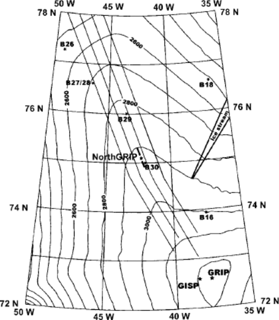
Map of North Greenland, showing surface contours, and the locations of GRIP, GISP2 and NorthGRIP and the ice stream suggested by Reference Fahnestock, Bindschadler, Kwok and JezekFahnestock and others (1993). Locations where shallow ice cores were drilled in 1994–95 are marked B16–B30. the four parallel lines are the airborne radio-echo lines measured in 1995 by NASA and University of Kansas (Reference Chuah, Gogineni, Allen and WohletzChuah and others, 1996a, Reference Chuah, Gogineni, Allen and Wohletzb). the 50 km long thick line over the NorthGRIP site shows the location of the radioecho sounding profile shown in Figure 2.
the site should be on the ice ridge in order to minimize disturbance by flow
the bedrock should be flat
the accumulation rate should be low enough that Eemian ice is as far from bedrock as possible, but not so low as to allow basal melting now or in the past.
Based on measurements of the accumulation rates in North Greenland (Reference Clausen, Gundestrup, Johnsen, Bindschadler and ZwallyClausen and others, 1988; Reference Bolzan and StrobelBolzan and Strobel, 1994; Reference Friedmann, Moore, Thorsteinsson, Kipfstuhl and FischerFriedmann and others, 1995; Reference FischerFischer and others, 1998) and 500 km radio-echo sounding profiles reaching from the GRIP and GISP2 drill sites in central Greenland along the ice ridge (Reference Chuah, Gogineni, Allen and WohletzChuah and others, 1996a, Reference Chuah, Gogineni, Allen and Wohletzb; Reference Dahl-JensenDahl-Jensen and others, 1997; Reference Gogineni, Chuah, Allen, Jezek and MooreGogineni and others, 1998), the NorthGRIP drill site was chosen 325 km north-northwest of the GRIP site (Fig.1).
The NorthGRIP Deep Drilling Site
The drill site is located on the north-northwest-trending ice ridge at 75.10°N, 42.32°W. the annual accumulation rate is measured to be 0.195m ice equivalent a–1 and the mean annual temperature is –32°C. the surface elevation is 2921 ma.s.l. and the radio-echo soundings reveal an ice thickness of 3080±20m (Reference Chuah, Gogineni, Allen and WohletzChuah and others, 1996a, Reference Chuah, Gogineni, Allen and Wohletzb; Reference Dahl-JensenDahl-Jensen and others, 1997). A strain net, established in 1997 and remeasured in 1998, 1999 and 2001, shows the horizontal surface velocity at NorthGRIP is 1.33±0.02ma–1 along the north-northwest ice ridge (Reference Hvidberg, Keller and GundestrupHvidberg and others, 2002). the horizontal strain rate in the flow direction is –0.4±0.6610–5 a–1, while the horizontal strain rate perpendicular to the ridge and the flow direction is 7.1±0.6×10⁻⁵ a–1 (Reference Hvidberg, Keller and GundestrupHvidberg and others, 2002). the horizontal velocity along the ridge is constant in the region around NorthGRIP.
The bedrock is very flat along the ridge (Fig. 2), with undulations 550 m. the radio-echo image shown in Figure 2 (Reference Dahl-JensenDahl-Jensen and others, 1997) shows well-resolved internal layers that are believed to be isochrons. the internal layers can be followed back to the GRIP drill site where they are dated. the deepest layer that can be traced at a depth of 2340m at NorthGRIP and 2420m at GRIP is dated to 52 kyr BP (Reference Dahl-JensenDahl-Jensen and others, 1997). the deep internal layers have undulations with amplitudes of up to 200 m, which cannot be explained by bedrock undulations or accumulation changes along the ridge. Reference Dahl-JensenDahl-Jensen and others (1997) suggested that the undulations were caused by changes in the geothermal heat flux along the profile.
A 50 km long section of the radio-echo imagery collected in 1996 with a 150MHz Coherent Arctic Radar Depth Sounder (CARDs) system (Reference Chuah, Gogineni, Allen and WohletzChuah and others, 1996a, Reference Chuah, Gogineni, Allen and Wohletzb). the profile passes 2 km east of the NorthGRIP drill site and follows the north-northwest-trending ice ridge. the location of the section is shown with a thick line on the map in Figure1. the internal reflectors are believed to represent isochrons, and the most prominent ones can be traced from GRIP to NorthGRIP. the deepest reflector that can be traced is the one marked on the figure as the 52 kyr BP isochron.

The NorthGRIP Deep Drilling Programme
Deep drilling started during summer 1996. the main structure of the camp is a wooden dome that contains a generator, kitchen, dining facilities, communication centre, desks for computers and a few beds. the drill is installed in a 6 m deep roofed snow trench that connects to the science trenches and the storage area for the ice cores. Weather ports on the surface are used as sleeping quarters for the 20–35 participants. A 110 m hole was drilled with a shallow drill, and the upper 100 m of the hole was cased to prevent loss of drill fluid. the European deep drill (Reference Gundestrup, Johnsen, Journé, Schwander and HempelGundestrup and others, 1996) was installed and a drill depth of 300m was reached. the 11m long European electromechanical drill retrieves core sections with a diameter of 98 mm that are up to 3.55 m long. During the 1997 season, the ice from 700 to 1200 mwas brittle due to the pressure of the air bubbles in the ice. Keeping the ice as cold as possible on the surface, leaving it for at least 1 week in core storage and handling it carefully in the science trench has resulted in a complete but broken ice core; all measurements have been made continuously through the brittle zone. the drill got stuck at 1310 m depth at a borehole temperature of –32.4°C. It was not possible to pull the drill free or to release it with glycol, probably due to the cold temperatures at the position where the drill was stuck. the 1310 m long ice core drilled in the years 1996–97 is referred to as the NorthGRIP 1 ice core. In the field, electrical conductivity measurements (ECM), dielectrical profiling (DEP) and studies of the air bubbles and clathrates have been performed. Samples have been cut for detailed measurements of ion chromatography, gases, physical properties, stable oxygen and deuterium isotopes.
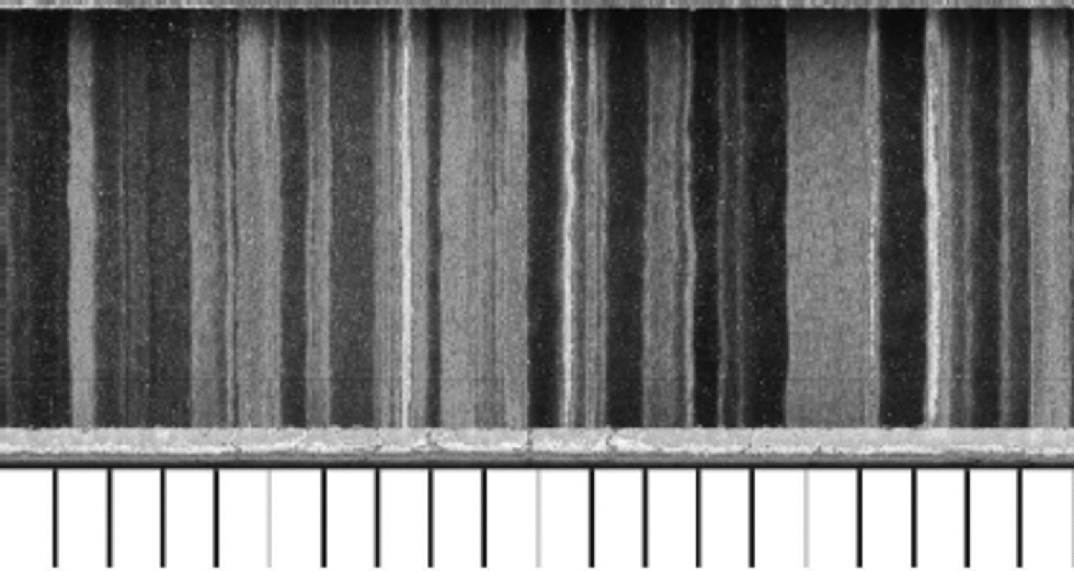
The 1998 season was used to build a new drill trench and prepare for a new deep drilling with a cased hole down to 110 m. In 1999 the NorthGRIP 2 ice core was drilled to 1750 m. Only DEP wasmeasured down to 1280 m, and the rest of the ice was stored on site for the 2000 season. In 2000 a team of 15 scientists worked with the NorthGRIP 2 ice from 1280m downto 2930 m depth. During this season, 30–50 m of ice was processed in the science trench each day. ECM and DEP was measured in the field, and a newly developed line-scan instrument was used to scan and record visible stratigraphy on a cleaned thick slab of the ice core (Fig.3). Several soluble chemical components as well as insoluble dust were measured continuously on the ice with a resolution of 1–2 cm (Reference Ruth, Wagenbach, Bigler, Steffensen, Röthlisberger and MillerRuth and others, 2001; Reference RöthlisbergerRöthlisberger and others, 2002; Siggaard- Andersen and Steffensen, 2002). the insoluble components for each 55 cm section were also collected on tephra filters for further analysis. Samples were taken for gas studies, as well as for discrete ion chromatographic studies, luminescence measurements, studies of the physical properties of ice and for the stable oxygen and deuterium isotopes measurements.
An example of the results from the line-scan measurements on the NorthGRIP ice core. A section of ice 20 cm long, 9 cm broad and 3.5 cm thick from a depth of 1802.80–1803.00 m is shown. A cm scale is shown below the picture. the visible features are recorded from an indirect light source. the ice appears to be striped with milky (white) and clear (dark) bands. This is a feature observed in ice from cold climatic periods. the milky bands are related to increased concentrations of dust. the sample shown here is from the Last Glacial Maximum, 23 kyr BP, where the annual-layer thickness is on average 1.8 cm.
The drill became stuck at 2930 m depth, where the borehole temperature is –7.2°C. Pellets of frozen glycol were dumped in the borehole so the glycol would pass the coldest part of the borehole before reaching the bottom where the high temperatures would allow the glycol to melt and act with the ice. After 1week the drill was freed, but the rest of the season was spent bailing the glycol/ice/water mixture up from the borehole (Reference Gundestrup, Johnsen, Hansen, Shoji, Talalay and WilhelmsGundestrup and others, 2002).
The 2001 season was used to drill 70m of ice from 2930 to 3001 m. the temperature of the ice here is between –7° and –5°C which is very close to the pressure-melting point of –2.4°C. the heat released from drilling brought the borehole liquid up to the melting point, making drilling difficult. A short version of the deep drill, referred to as the ``Hans Tausen’’ drill, was used to improve the performance, but the resulting average core length for the season was only 0.30 m. the drill was stuck and freed four times during the season using 2–3 kg of frozen pellets of glycol each time. on 30 July it was decided to stop the drilling for this season.
Discussion
Preliminary oxygen isotope, ECM and DEP measurements indicate that the Eemian ice has not been reached at the present depth of 3001 m. This is unexpected, as it was predicted by models to be found at 2750–2850m depth (Reference Dahl-JensenDahl-Jensen and others, 1997). Two explanations are offered: that the Greenland ice sheet had retreated from NorthGRIP during the Eemian (Reference Koerner, Bourgeois and FisherKoerner and others, 1988; Reference Cuffey and MarshallCuffey and Marshall, 2000) and that the basal ice has melted away. If no ice remained over NorthGRIP during the Eemian, the stable-isotope values of the deep ice should be significantly increased due to a much lower elevation of the site where the snow was deposited 110 kyr BP. Comparison of the preliminary stable-isotope values from NorthGRIP with those from GRIP does not support this. the preliminary temperature profile from the logging of the borehole performed on 1 August 2001 shows that the temperature is at the melting point at the bedrock, 80m below the present depth. the temperature gradient indicates a heat flux up through the ice of 55 mWm–2, which is higher than the flux of 51 mW m–2 at GRIP. the fact that we have not reached Eemian ice and that the layer thickness is still about 1cm suggests ice melting at the bedrock or upstream from it, now or in the past. Model results presented by Reference Grinsted and Dahl-JensenGrinsted and Dahl-Jensen (2002) suggest melt rates of about 5 mm a–1. This would require a geothermal heat flux of 100 mW m–2, which implies that the NorthGRIP borehole is in a region where the bedrock is atypical for the Precambrian shield believed to cover most of Greenland.
Radio-echo sounding profiles (Reference Chuah, Gogineni, Allen and WohletzChuah and others, 1996a, Reference Chuah, Gogineni, Allen and Wohletzb) do not show isochrons drawn down at NorthGRIP to 2700 m, where the deepest internal layers are observed locally. the deepest isochron that can be followed from GRIP to NorthGRIP is the 52 kyr BP isochron mentioned earlier, and this horizon is found at the predicted depth in the NorthGRIP ice core. This leads to the conclusion that possible dipping layers can only be found below the 52 kyr horizon, where no horizons are detected. the basal melting zone might extend far up along the ridge towards the GRIP site. the deep internal layers along the ridge at NorthGRIP (Fig.2) have undulations, and east of NorthGRIP, where the accumulation rates are lower, the amplitude of the undulations of the internal layers is even larger. Decreased accumulation rates result in warmer basal temperatures, so the undulations are believed to be related to warm basal temperatures, melting and bottom sliding. But why do the layers undulate here and at the NorthGRIP site? An explanation might be changing geothermal heat fluxes probably due to 10–20 km broad bands of bedrock with increased geothermal heat flux. With a present-day surface velocity of 1.33 m a–1 the deep ice at NorthGRIP originates 50–100 km upstream from the drill site and has passed several of the regions where the layers dip and the basal melting is assumed to be largest. the flowline from GRIP to NorthGRIP passes the onset region of the ice stream in northeast Greenland 200 km upstream from NorthGRIP (Fig. 1). the 115–130 kyr BP old Eemian ice is not believed to be influenced by basal melt from here since the ice cannot have originated from so far upstream.
Conclusions
It is disappointing that the Eemian ice is not found far from bedrock as predicted. the deep ice from the NorthGRIP ice core, however, has a unique property precisely because there is or has been basal melting. the deep layers have not been thinned as much as expected, resulting in layers twice the thickness of those found at GRIP and GISP2. All the annual layers in the 110 000 year long glacial period have a thickness of the order of 1cm. With modern analytical methods it will be possible to retrieve a detailed climatic record with annual resolution through the onset of the last glacial period 115 kyr BP.
Acknowledgements
The NorthGRIP project is directed and organized by the Department of Geophysics at the Niels Bohr Institute for Astronomy, Physics and Geophysics, University of Copenhagen. It is supported by Funding Agencies in Denmark, Belgium, France, Germany, Iceland, Japan, Sweden, Switzerland and the United States of America.


