Introduction
Glaciers in Patagonia are temperate, with high accumulation and ablation rates (Naruse and Aniya, 1992). Thus, these mountain glaciers are expected to have short (less than 100 years) response times to climate changes (Jöhannesson and others, 1989). However, the response may be complicated by the calving nature of most glaciers (Warren and Sugden, 1993).
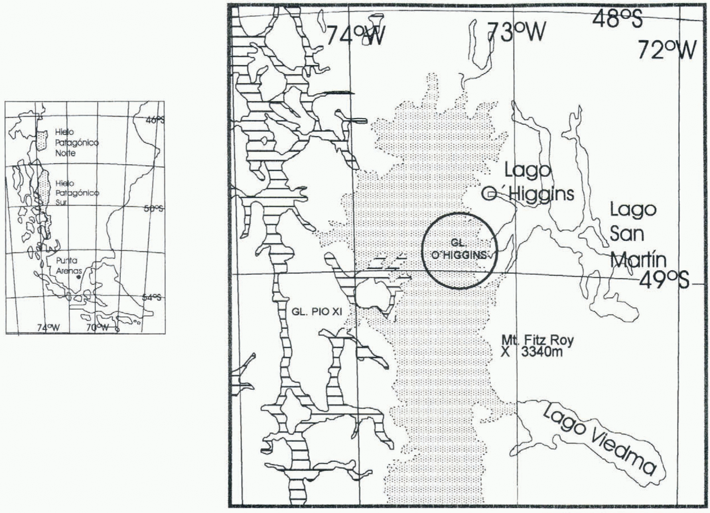
Glaciar O’Higgins is the fourth largest glacier in Hielo Patagónico Sur (HPS; southern Patagonia ice field), flowing eastward and calving into Lago O’Higgins. It has undergone the largest retreat of all glaciers in Patagonia, as has been observed by early settlers and explorers (Shipton, 1963) and from aerial photographs and satellite imagery from 1945 to 1986 (Aniya and others, 1996). Here we extend the record of frontal variations of the glacier to cover the period 1896–1995, and discuss possible causes of this retreat.
Glaciological Characteristics
The glacier has a total relief of 3127 m, from Volcán Lautaro (3380 m) to Lago O’Higgins at 253 m (IGMC, 1982), where it calves into freshwater. It is bounded on the west by Glaciates Bernardo, Tempano, Occidental, Greve and Pio XI; on the southeast by Glaciar Chico; and on the south by Glaciar Viedma (Fig. 1). Glaciar Pio XI is the largest glacier in HPS, and Viedma is the third largest (Aniya and others, 1996).
The best topographic coverage of HPS as a whole is the 1:250 000 preliminary sheets compiled by the Institute Geográfico Militar de Chile (IGMC, 1953), based on 1945 aerial photographs. From these maps, and a Landsat TM image of 14 January 1986, Aniya and others (1996) calculated a length of 38–46 km, an accumulation area of 645–793 km2 and an ablation area of 109 km2. The average width of the glacier is 4 km in the ablation area. In the accumulation area, where topography is fairly subdued, ice divides could not be determined reliably, due to the poor stereoscopic view in aerial photographs. Therefore, the accumulation area can only be expressed as a range of values rather than a single value. The equilibrium-line altitude was estimated to be 1300 m based on the position of the snowline on the Landsat TM image at the time of image acquisition, and elevations derived from the Preliminary Sheets, but this elevation is probably too low since the image was taken in mid-summer.
No field data exist for Glaciar O’Higgins, so ice velocities, thickness, ablation and accumulation rates, and meteorological characteristics are all unknown. Also, no data of water depths of Lago O’Higgins near the calving front are available.
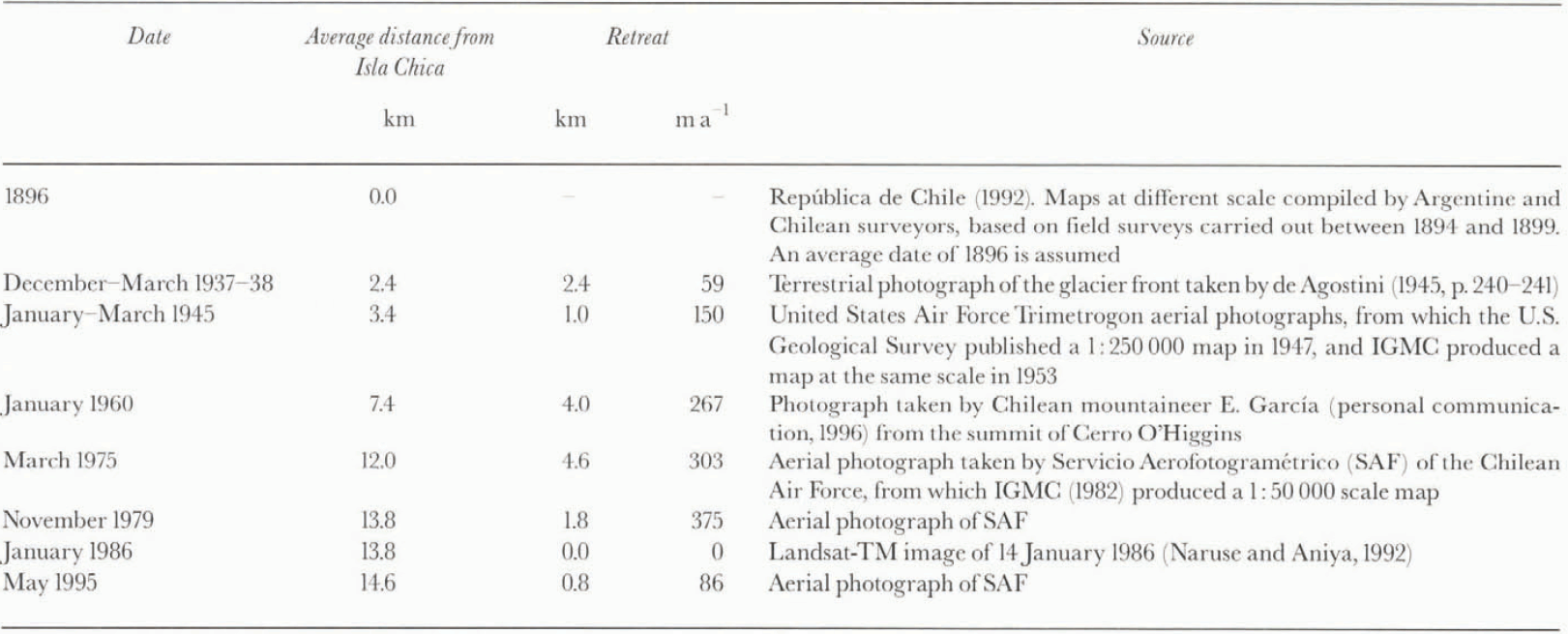
Historical Record Of Frontal Positions
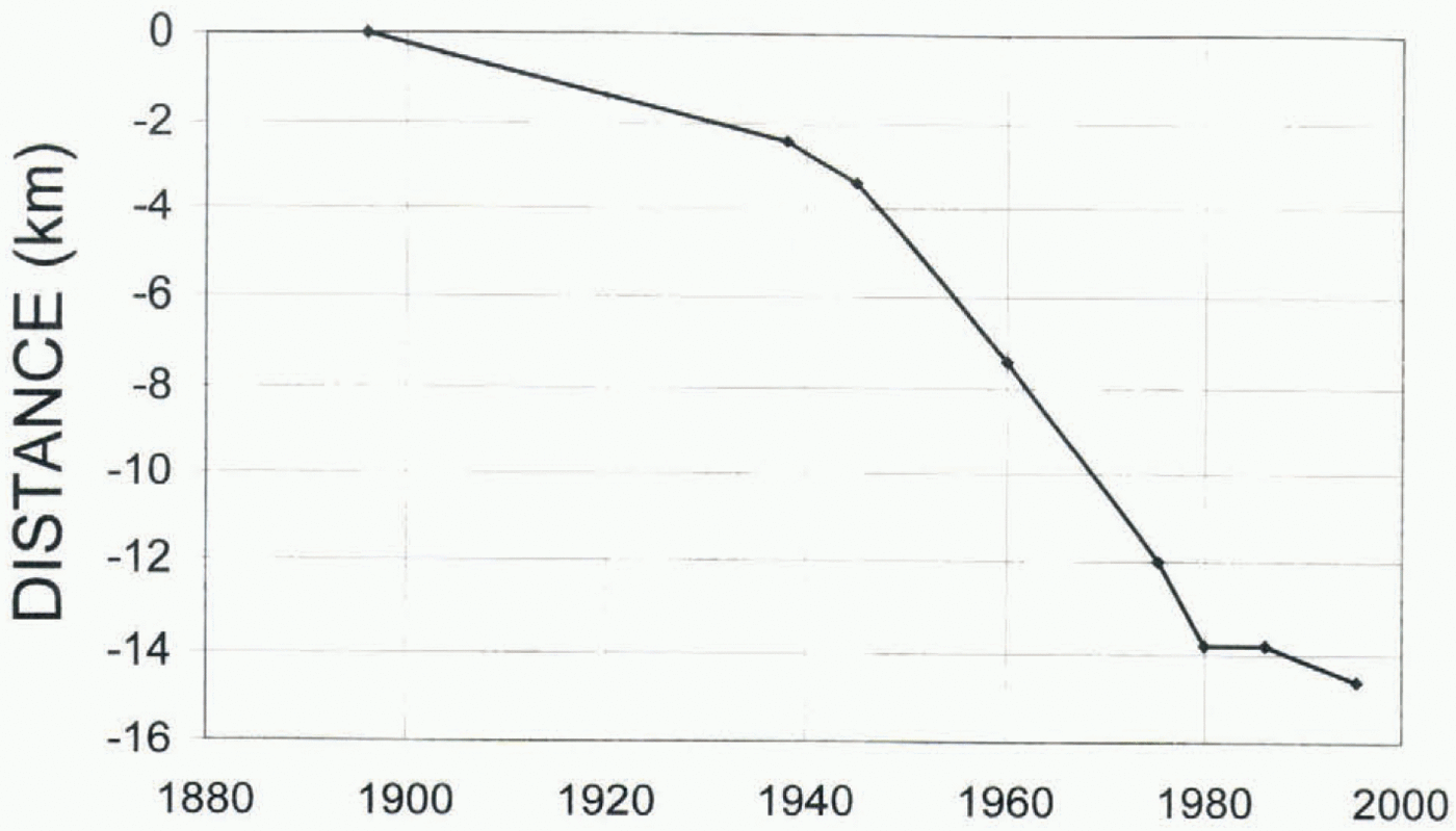
Information from maps, terrestrial and aerial photographs, and satellite imagery was used to reconstruct the historical record of frontal variations for Glaciar O’Higgins (table 1). It covers the period from 1896, the date of the earliest available maps, to 1995, when the most recent aerial photographs were taken (Fig. 2). The average distance in Table 1 was determined visually for each epoch.
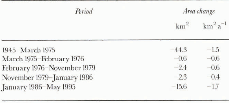
Area Change
Based on aerial photographs and satellite images, area changes of Glaciar O’Higgins have been calculated from 1945 to February 1976, February 1976 to November 1979, and November 1979 to January 1986 (Aniya and others, 1996; Table 2). The February 1976 data were obtained by Aniya and others from a Landsat MSS image. Because this image was not available for the present study, an area change rate of 0.6 km2 a−1 was assumed between 1975 and 1976, the same rate as that between 1976 and 1979. The values have been updated to 1995 in this study by using the position of the glacier in 1975 according to the IGMC 1:50000 map
Average position of the front of Glaciar O’Higgins
Location of Glaciar O’Higgins. The dotted area is the northern part of Hielo Patagónico Sur. The fjords on the west are hachured, and the lakes on the east are shown in white.
(IGMC, 1982), and the position in 1995 plotted from the Servicio Aerofotogramétrico May 1995 aerial photographs on the IOMC map (table 1). The 1995 position was plotted stereoscopically using a Zeiss Stereotope. From the data it is evident that there has been a drastic area loss in the period 1986–95, not matched by a significant retreat of frontal position. Considering that warming has affected the region during the 20th century (Rosenblüth and others, 1995), it is probable that the area loss is a response to warming, whereas the relative stability of the front in recent years may relate mainly to dynamic conditions at the calving front.
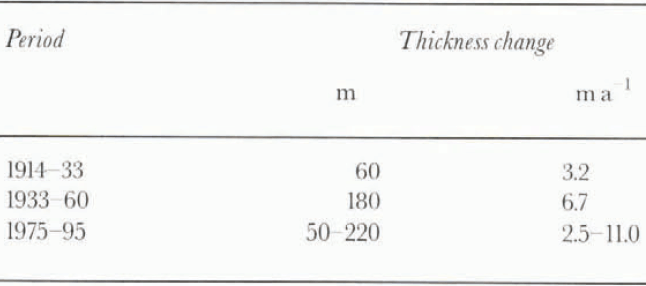
Ice Thickness Change
The British explorer E. Shipton, made the following estimates of ice thickness change, in his expedition account of 1959–60 (Shipton, 1963).
He estimated a change of about 60 m from 1914 to 1933 at a point near the front of the glacier in 1960, based on the recollections of A. Altamirando, a local settler who first visited the glacier in 1914 and accompanied Shipton in 1959–60, and of Mrs von Rensell, a member of Dr Reichert’s expedition of 1932–33. Shipton further estimated a thickness
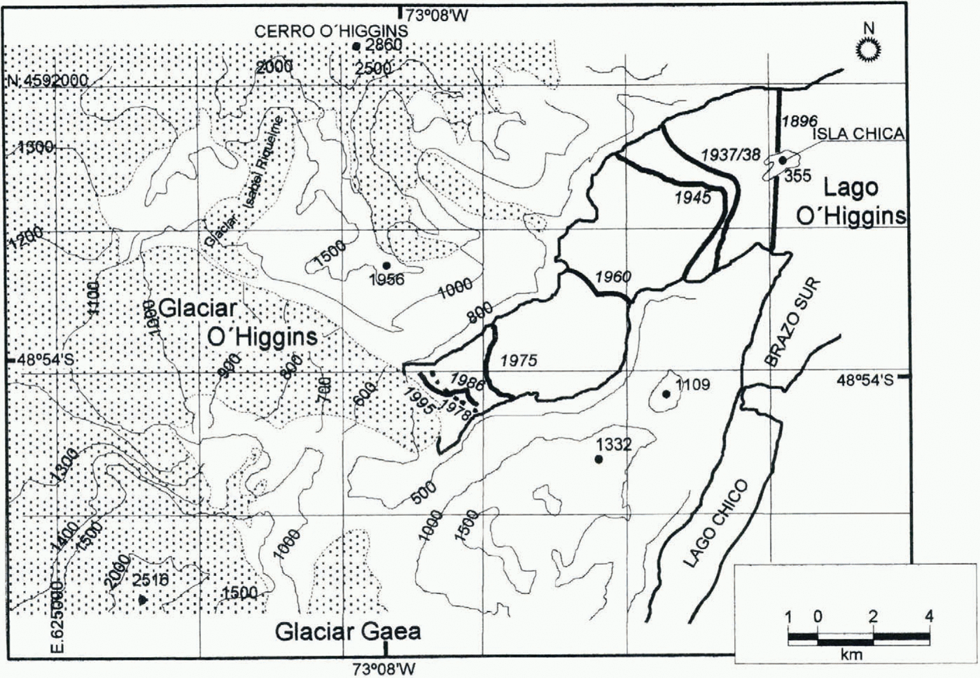
Topographic map of Glaciar O’Higgins. The position of the glacier front at different epochs is shown. Elevations are photogrammetrically determined from the 1GMC 1975 1: 50000 “Cerro O’Higgins” map (IGMC, 1982). The edge of the ice, drawn from the IGMC’s map, represents the position in March 1975, except for the tongue of Glaciar O’Higgins, where the edge was drawn from aerial photographs of May 1995. UTM coordinates on a 5 km grid are shown. Note that the ice north of Glaciar GAEA, where there used to be a large curve in the glacier in 1945, has practically disappeared in recent years.
change of about 180 m from 1933 to 1960, at a point near the front of the glacier in 1960, based on descriptions by Mrs von Rensell in 1933 and by himself in 1960.
Comparing measurements in a stereoscopic model from a pair of 1995 aerial photographs, and the ice elevations of 1975 shown on the IGMC (1982) 1:50 000 map, we estimate thinning in the ablation area in the period 1975–95 to range from 50 m at 1200 m elevation on the IGMC (1982) 1:50 000 map (15 km from the frontal position in 1995), to 220 m at the front of the glacier in 1995.
These data are used to calculate approximate thinning rates for the lower ablation area of Glaciar O’Higgins (table 3). Even though the frontal position is probably governed mainly by calving dynamics, with some climatic influence as well, the increased area loss and ice thinning measured in recent years, occurring not only at the glacier front but also at 1200 m elevation (table 3), indicates that the glacier has been responding mainly to climate.
Discussion
In 1896, the front of Glaciar O’Higgins stood at Isla Chica. Therefore, it seems probable that Isla Chica was acting as a local pinning point, stabilizing the glacier front position for a period of time.
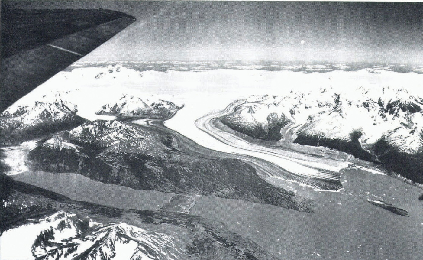
As can be seen in the 1945 aerial photographs (Fig. 3), prominent trim lines appear at each side of the valley of Glaciar O’Higgins, indicating recent retreat. The northern trim line descends gradually to lake level near Isla Chica. Similar prominent trim lines are observed above virtually all present glaciers in Patagonia. This “neoglacial maximum” can be considered to be equivalent to “the Little Ice Age”, well documented in the Northern Hemisphere.
At some time between 1896 and 1937–38 the glacier started retreating from Isla Chica, probably in response to climatic warming and perhaps to a precipitation decrease as well. Virtually no climatological trends exist before 1900 in the region. Since the beginning of the century, Rosenblüth and others (1995) report, there has been a warming of 0.4–1.4°C south of 46° S. At 52–53° S a 25% decrease in precipitation
Area change for Glaciar O’Higgins
Approximate thinning of Giaciar O’Higgins, in the lower ablation area. See text for data sources

is reported for the same period (Rosenblüth and others, 1995), although no significant trend is observed between 41° and 52° S.
Because Giaciar O’Higgins faces eastward, it receives much less precipitation than western-facing glaciers such as Giaciar Pio XI (Warren and Rivera, 1994). Therefore, the climatic regime of Glaciar O’Higgins is predominantly continental, so we can assume that it responds predominantly to temperature rather than precipitation.
As the glacier detached from Isla Chica and retreated into the fjord, presumably into deeper waters, we can assume that there was increased calving (Warren and others, 1995). Therefore, at this stage, climate is a minor factor. Accelerated retreat took place until 1979, reaching a maximum (375 m a−1) in 1975–79. The front was stable from 1979 to 1986, then started retreating again, although at more moderate rates (86 m a−1) (Fig. 4). One possible explanation for the slower retreat is that the water is shallower in this part of the lake.
Another possibility is increased geothermal and volcanic activity of Volcán Lautaro, which could possibly influence the thinning of Glaciar O’Higgins, due to enhanced basal warming. Both Reichert’s expedition in 1932–33, and Shipton’s in 1959–60, reported volcanic activity. However, there is no report of volcanic activity since 1960. Considering
Trimetrogon oblique aerial photograph of Glaciar O’Higgins, looking west, taken sometime between January and March 1945. The glacier front was calving close to Isla Chica. Volcán Lautaro is on the left, below the tip of the airplane wing.
Positions of the front of Glaciar O’Higgins at different epochs, from sources described in the text.
the accelerated thinning experienced by the glacier, at least in recent years the ice loss seems to be unrelated to geothermal and/or volcanic activity.
Conclusions
Climate warming probably triggered the retreat of Glaciar O’Higgins from Isla Chica sometime between 1896 and 1914. We propose that the large frontal retreat of 14.6 km between 1896 and 1995 is due to increased calving in deep water as the glacier retreated westward. Although the retreat has slowed considerably in recent years, perhaps due to reduced calving in shallower waters, thinning and surface area loss are occurring at the highest rates of the century, suggesting a response to enhanced warming.
Acknowledgements
The work was funded through Project FONDECYT 1950722, and through the support of Universidad de Magallanes. Prof. M. Martinic of Institute de la Patagonia provided valuable historical information. The collaboration of E. Garcia is appreciated. Digitizing was performed by P. Salazar. Maps were drawn by R. Smith and A. Oyaneder.