

Introduction
Any curious visitor to downtown Buenos Aires in Argentina can find the Town Hall only a few metres away from Mayo square and the presidential palace or “Pink House”. The Town Hall's White Room, continuing with the colour theme, hosts a painting that is permanently on display that symbolises the city's humble origins (see figure 1).
José Moreno Carbonero (1858–1942), “La Fundación de Buenos Aires en 1580” (The Founding of Buenos Aires in 1580) (1923).
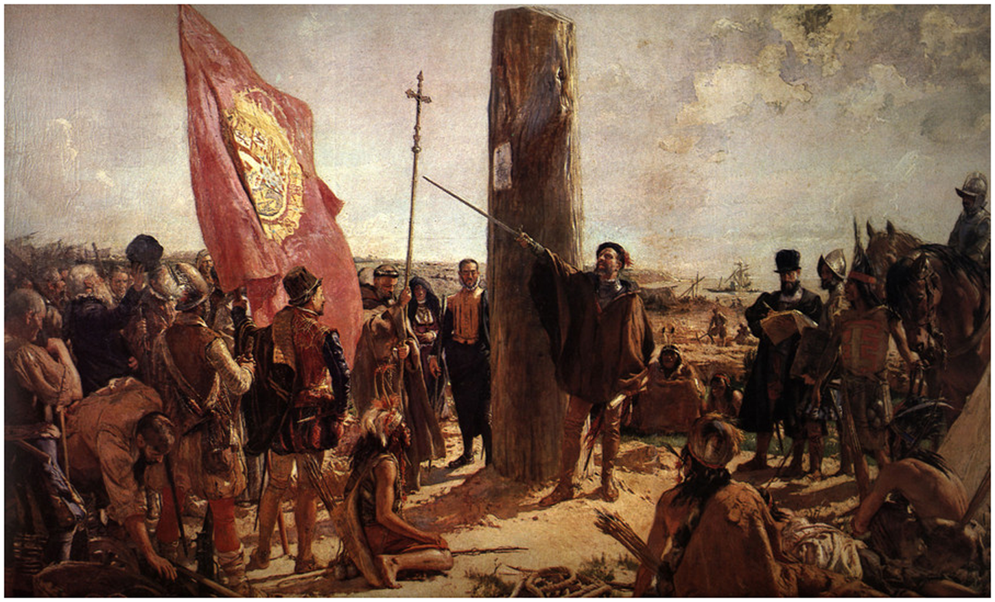
Painted by Spanish artist José Moreno Carbonero (1858-1942), “La Fundación de Buenos Aires en 1580” (The Founding of Buenos Aires in 1580) dates from 1923 and, as the title suggests, recreates the starting point of the city on 11 June 1580, centred on the Basque conquistador Juan de Garay. The painting became a symbol of the city and was popularised through school manuals during the 1976-1983 military dictatorship. It even had a brief appearance on a banknote that went into circulation in Argentina marking the city's four hundredth anniversary. This painting is also product of nineteenth-century historiography that, based on a literal reading of historical records of the establishment of cities and towns, romanticised these events in the collective memory through visual representations, sculptures, and a narrative that describes conquistadors as heroes and town foundations as the product of European civilisation in the New World. This historiography tried to establish a connection between the Liberal and pro-European national states in Latin America in the late nineteenth and early twentieth centuries and a reimagined and distant Hispanic and colonial past. This was briefly revived during the military Junta of the late 1970s and early 1980s.Footnote 1
By the mid-twentieth century, a new historiography, focused on institutions and concerned with the construction of national states in Latin America, looked at town foundations with a different emphasis. It studied their cabildos (city councils) and their role in the construction of an administrative and political apparatus in the colonies. This scholarship sees cities as political bodies (civitas), seeds of a Colonial State and key players in its organisation in Spanish America.Footnote 2 Urban centres thus became enclaves of Spanish colonisation surrounded by indigenous peoples. Both this approach and the one epitomised in the painting by Moreno Carbonero pose nonetheless some challenges. On the one hand, they ignore the complexities of indigenous agency in the construction of urban spaces because they simply oppose the Spanish versus indigenous peoples. In this comparison, natives frequently appear either as a workforce or as a threat to the stability of these new towns. They also assume a single Spanish agency and are unable to understand the multiple interests among the Europeans involved with town foundations. Finally, they retrospectively build a colonial State, as the predecessor of the liberal states, which constitutes an anachronism. They also focus on these towns’ initial times without providing an explanation over their post-foundation situation.
The scholarship of the last four decades on the southeast of Charcas, in present-day Bolivia, which is the geography that this article studies, began addressing this, understanding the district's frontier, and therefore its towns, as a permeable space with complex social dynamics.Footnote 3 The pioneering works of Saignes, followed by those of Combès, prepared this path through an analysis of frontier indigenous peoples and their interaction with Tahuantinsuyu first and the Spanish after.Footnote 4 Saignes's studies were contemporary of García Recio's own work on Santa Cruz de la Sierra and the creation of a “frontier society”.Footnote 5 Both themes continued in later works. The book by Gutiérrez Brockington on Mizque also follows these ideas.Footnote 6 The unpublished theses of Scholl and Weaver Olson on the same frontier, studied more carefully such interactions and the creation of “republics of lost peoples” which combined the Spanish, mestizos and natives, in the margins of Charcas.Footnote 7 More recently, the works of Oliveto and Revilla Orías highlighted the importance that indigenous slavery and other forms of indentured servitude had in that space.Footnote 8 Finally, Oliveto's recent book on Tarija provides a case study, describing the complexities of the expansion of Tahuantinsuyu and the Spanish into the district, and the challenges that both processes posed to its indigenous peoples.Footnote 9 Town foundation has been the subject of a recent article on the creation and destruction of San Miguel de la Laguna, also in Charcas, as a process built on a partnership between the Guaraní-speaking ChiriguanaesFootnote 10 and the Spanish in the town.Footnote 11 Building on these contributions, the present article proposes an analysis of the establishment of San Juan de la Frontera de Paspaya as a collectively driven process which, involved Spanish captains and their men, indigenous peoples classed as “enemies” and “friends”, the Royal Court of Justice (Real Audiencia) in La Plata, the Andean chiefs with communities settled in towns in the frontier, and religious orders. This process reflected multilayered interests and involved appropriations and reappropriations of resources, meanings, and a geography, which were conducted by individuals and groups through their daily activities.Footnote 12 The frontier, “an overlooked place with overlooked peoples” as Velasco Murillo recently suggested,Footnote 13 was therefore constructed as a relational space, with the intervention of agents within and outside, and it was built from above and below, at the same time. The importance of such frontier towns in the economy of Potosí, the Spanish Crown's “jewel”, which relied on their resources and supported their safety, makes the study of the establishment of these urban spaces paramount to understanding the social and political dynamics in the whole of Charcas. Any development in the southeast frontier of the district could potentially disrupt the activities in Potosí and have consequences on the finances of the monarchy. Although on the margins of empire, the presence of Potosi gave Charcas its own weight in the global polity.
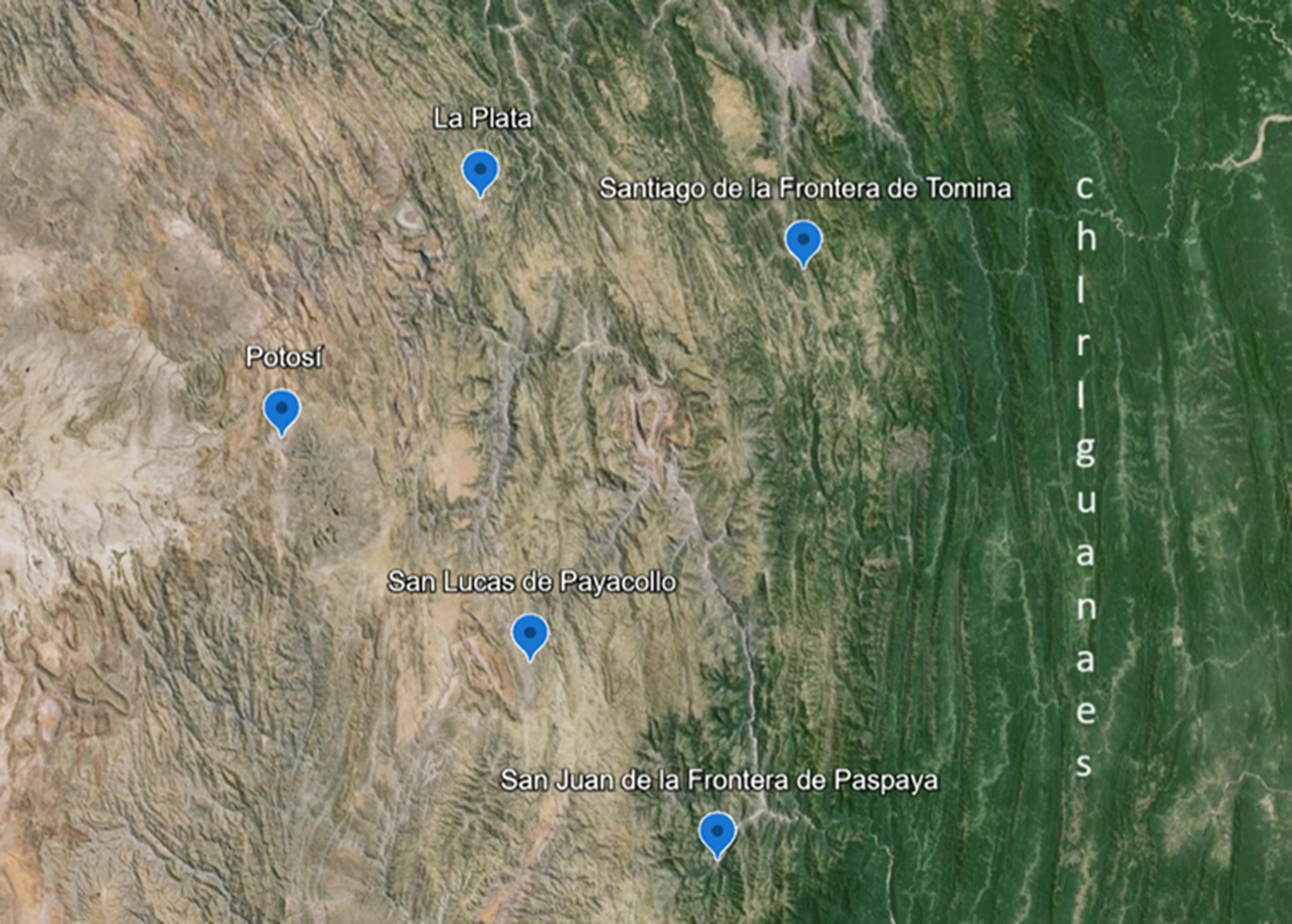
As part of the same town foundation process, the frontier began to be politically equipped with institutions, such as cabildos and corregidores or royal officials, and a whole range of personal, legal, and political relations, gradually adopting its own identity as a territory of the Catholic monarchy, product of the exchanges of the groups and individuals involved.Footnote 14 This process adapted or “localised the monarchy” and its institutions and offices, creating “locality” or a unique political community, at the same time.Footnote 15 This article also suggests that the whole process was shaped by a practice of government centred on iurisdictio (jurisdiction), understood in its early modern meaning as the authority to proclaim and exercise justice, and the administration of royal rewards; as well as “empowering interactions” created through engagements in communicative processes which were the result of diverse and reciprocal interests.Footnote 16 The case of San Juan de la Frontera de Paspaya offers a unique opportunity to understand this process due to the relatively abundant records, compared with other frontier towns, over its foundation and the early years of its existence (see map 1 below).
Southeast Charcas frontier circa 1590. Map done by the author using Google Earth.
A Case Study: San Juan de la Frontera de Paspaya
Following months of ocean travel, and even a mutiny, Juan Ladrón de Leyba (1553-1613) arrived in Chile in 1576 as captain part of a “socorro” (backup expedition) organised by Chile's governor Rodrigo de Quiroga and the Consejo de Indias, the royal body responsible for the Indies, to bring reinforcements for the war on the Araucanians.Footnote 17 Ladrón de Leyba is described on the list of expedition members as Toledo-born, aged twenty-two, moreno (dark-haired), of average height and with a scar across his head.Footnote 18 The young soldier met his future partner and mentor, the Mercedarian friar Antonio de Escobar, in Chile. The area was classed as a war frontier described by the Spanish as the “Flanders of the Indies”.Footnote 19 It is likely that when news broke there over the resumed prosperity of Potosí due to the introduction of the amalgamation of silver in the final years of the 1570s, both Ladrón de Leyba and Escobar started planning the establishment of a town in the east of Charcas to reap the benefits of abundant and fertile land for cultivation or cattle rearing and timber in that area.Footnote 20
Due to their role in the rescue of captives across the Spanish Empire, Mercedarians were always involved with agents who were active in frontiers and the connection between Escobar and Ladrón de Leyba, apart from personal reasons, reflects this very well.Footnote 21 The role of these members of religious orders as brokers between different actors played a significant part in the construction of frontiers. These priests were supposed to bring indigenous peoples into the fold of Christianity, teaching them a whole range of civic values that would eventually turn them into vassals of the Spanish king and members of the Catholic community. They also had to “watch” other groups such as mestizos, blacks, and the Portuguese and others classed as foreigners, as there were always fears about their “loyalty” and “Christian credentials”. However, religious orders also had to prevent the Spanish from slowly “turning native” in such remote environments, gradually shifting loyalties and, moving away from Christianity. The partnership between Escobar and Ladrón de Leyba also took place at a time when the Jesuits were only timidly rebuilding their presence in Perú, after a period of tension with Viceroy Francisco Álvarez de Toledo (1569-1581).Footnote 22 It also happened during a period of reform of the Mercedarian order whose members had been associated with a lack of discipline and siding with the rebels during the Civil Wars (1538-1555) in Perú.Footnote 23
Escobar left central Chile first, briefly settling in Atacama, under the protection of corregidor Juan Velázquez Altamirano. The friar's determination to stop men from travelling to Chile and fighting there had created enemies in his old home. They wrote to the authorities asking, “for the love of God … someone removes this priest from here”.Footnote 24 His appointment as a priest in San Lucas de Payacollo, an Indian town settled in 1578 by Viceroy Toledo that was home to Quillaca, Charca, Asanaque and Visisa natives in the southeast frontier of Charcas, brought relief to the authorities in Chile and gave the priest the opportunity to start preparing the ground for the arrival of his partner Ladrón de Leyba in Charcas in 1584.Footnote 25
What was the situation that Escobar found upon his arrival in Charcas? Toledo had been succeeded by Don Martín Enriquez (1581-1583) who passed away around two years in his post as Perú's viceroy, leaving the Real Audiencia de Charcas, fully in charge of the district. The Real Audiencia took this opportunity to expand its scope of political action assuming military functions normally attributed to viceroys. In the southeast frontier, the 1574 punitive expedition by Toledo against the Chiriguanaes had had little impact on their regular raids that had become more intense. It did, however, result in the foundation of San Bernardo de la Frontera de Tarija (1574) and Santiago de la Frontera de Tomina (1575). As another friar, Reginaldo de Lizárraga, remembered two decades later, the expansion of silver production in Potosí was “crowding these valleys” and the new towns were a testimony to this.Footnote 26 Ladrón de Leyba himself wrote decades after about the integration of the southeast frontier with Potosí stressing the presence of “a large number of farms of all sorts of livestock where meat can be obtained and the pastures of that frontier area nurture the largest number of camelids that bring ore from Cerro Rico in Potosí to the lowlands. And from that frontier timber and coal are extracted to feed the smelters and the farms in that frontier provide maize, corn, wine, honey and other supplies, including fish, in large amounts. For this reason the whole region is priceless”. Footnote 27
Despite Ladrón de Leyba's admiring words, farms faced serious labour shortages because of a lack of natives prepared to be put to work under encomienda grants in the area. The alternatives were the exchange of captive natives seized by the Chiriguanaes, and the use of indigenous peoples who, having fled the mining work shifts in Potosí, had taken shelter in the remote frontier.Footnote 28 With vacant lands that could not be cultivated because of the incursions of Chiriguanaes, and an abundance of captives and fugitives, the frontier was perceived as an area that, although attractive, was only marginally overseen by the authorities, who were not able to police it properly. In terms of the political culture at the time, it was a space ready to be equipped with institutions and relations and to be transformed into a territory of the Spanish Empire. From this perspective, the foundation of towns would offer a unique opportunity to those with the political and financial support to do so, as it had happened with San Bernardo de la Frontera de Tarija and Santiago de la Frontera de Tomina. In addition to the status that town foundation could provide, this was also perceived as a political and spiritual mission based on ideals of service and loyalty to a Catholic monarch that entailed carrying that royal presence and his religion to every corner of the globe.Footnote 29
In this global polity, where multiple and coexisting layers of interests were the norm, this was reflected in a plurality of laws and authorities. Town foundation was a unique opportunity for the monarchy to aggregate new territories, delegating jurisdiction on them. The Real Audiencia also benefitted, being able to establish patronage ties with the new political communities organised around these urban spaces. It gave the leaders of these communities the possibility of social promotion, gaining access to land and resources, earning prestige for themselves and for their extended political clients and relatives. In San Juan's case, it would give the indigenous communities of San Lucas de Payacollo and their chiefs the option to access more cash to pay royal tribute, a new market for their products, more security against any Chiriguana raid, and an extra workforce for their own fields. Finally, although the Chiriguanaes lost space, they would also gain a market for their captive natives and access to sumptuous items, as well as the option to perform more raids and seize property and captives from a Spanish town if things did not work out well. Town foundations went hand in hand with the creation of jurisdictions and were the result of collective processes, aggregating new geographies and their peoples, in this case the Chiriguanaes and other natives beyond the frontier, to the immense global mercantile space of the Catholic monarchy.
Early in the 1580s, and after the Toledo's expedition's defeat, the regular raids of the Chiriguanaes on farms and travellers became more prominent and the victims were now of higher prestige in Charcas.Footnote 30 Faced with this situation, the Real Audiencia began preparations for a large-scale campaign over three separate fronts which were accelerated after the destruction of the town founded by Captain Miguel Martín early in 1584, at the time of the arrival of Ladrón de Leyba to Charcas.Footnote 31 As part of the process to organise a punitive campaign, the corregidor de Indios (royal official responsible for the protection and collection of tribute from the Indian towns in the frontier), Francisco de Lazarte y Molina, interviewed the native chiefs who shared the town of San Lucas -Don Alonso Acama, Don Juan Tapalco, Don Alonso Chuquivilca of the Visisa Indians, Don Martín Chico of the town of Chaquí; and Don Francisco Guarache and his son Don Diego Copatete of the town of San Lucas -and their encomienda holders- Cristóbal Barba y Alvarado, Antonio Pantoja de Chaves, and Francisco Zarate de Ondegardo- late in 1583 seeking a solution to the regular Chiriguana attacks.Footnote 32 Until then, with support from their encomenderos, these chiefs had been tasked with overseeing that section of the southeast Charcas frontier, as their ancestors had done under Tahuantinsuyu.Footnote 33 The indigenous leaders insisted that their town and the property of their communities, including a cattle farm called Pototaca where they had between five thousand and six thousand animals, needed protection and all sides agreed that the best way to do it was through the establishment of a Spanish town; something that the Real Audiencia had suggested already and that would require time. As a first step, and due to the urgency of the events, following the recommendation of Father Escobar and the native chiefs of San Lucas, Ladrón de Leyba was appointed caudillo (military leader) in the area, with jurisdictional faculties, including powers to seize and return fugitive Indians to their towns or settle them in San Lucas. Leyba's appointment in March 1584 was a key moment for the project to establish a new frontier town. It would provide immediate security and workforce for the area's farms.Footnote 34
Upon his arrival in San Lucas, Ladrón de Leyba and Father Escobar began preparing the ground for the future town, strengthening their ties with the native chiefs of San Lucas immediately. They were trying to create a support network to build their own authority. To clear any future jurisdictional problems, Ladrón de Leyba also contacted Luis de Fuentes y Vargas, Corregidor of San Bernardo de la Frontera de Tarija, who had the area of San Juan de la Frontera de Paspaya in his district, even when the distance between his town and these valleys was enormous. Fuentes y Vargas agreed to relinquish his rights and authority over San Juan de la Frontera de Paspaya, whilst still overseeing San Lucas, insisting that his wages as a corregidor did not include the area, which he still had to oversee.Footnote 35 This was a partnership that reinforced both frontier captains who could now defend two sections of the frontier, helping each other, without having to resort to the Real Audiencia. Through these ties the future of San Juan was built from within the same frontier.
With an idea of the actual jurisdiction of the future town, the next step was to enlist future settlers and partners. Escobar probably had a long list of contacts and brought together Ladrón de Leyba with his future lieutenant in San Juan de la Frontera de Paspaya, Andres Sánchez Serrano, someone who would also contribute funds and men to the operation.Footnote 36 With these supports, the future Spanish town began to take shape. This was still a project that had to be discussed with the Real Audiencia and had to be confirmed through capitulaciones and asientos, (legal and political contracts). Jurisdiction had to be negotiated and agreed both on the ground and in court.
The discussions with the Real Audiencia took place simultaneously in the months after Ladrón de Leyba's arrival in San Lucas. They had two sticking points, both concerning the men that would be used to settle the new town. On the one hand, the number of people that Ladrón de Leyba was going to take to the new town was an issue. The Real Audiencia was alarmed by the suggestion that he would only travel with twenty men. Ladrón de Leyba said that they would go with “their mature children, many were also married and would take their servants”, suggesting that the final figure would be larger, adding that he would feed them until they could collect their first harvest.Footnote 37 This generous commitment would reduce any chance for the men to abandon the project which largely depended on the produce of the land. The other sticking point was about the indigenous labour that San Lucas de Payacollo could provide. Ladrón de Leyba asked for 120 natives. The Real Audiencia suggested forty, raising concerns over the impact that a larger number could have over the Indian town. This significant gap suggests that both sides were tacitly agreeing that captive natives exchanged with the Chiriguanaes would make up the difference.
Finally, the discussions focused on fiscal, defence and jurisdictional matters. Ladrón de Leyba secured an exemption of the half percent tax on grain sales in Potosí by farms from the new town. This would make such farms and their activities more profitable. The captain had to accept less gunpowder than the volume he had requested due to concerns by the Real Audiencia that any excess gunpowder might be handed to the Chiriguanaes, as had happened in the past. Ladrón de Leyba also agreed to build a fort in the new town and secured the title of perpetual alderman of the fort. Ladrón de Leyba was finally named captain for the rest of his life. However, he was only allowed to bear the title of corregidor of whatever “he would populate” for the length of time that the monarch would decide, meaning that eventually he would have to seek the ultimate royal endorsement for this post. With this formula, on the one hand, the Real Audiencia upheld the monarch's right to bestow such posts on whoever had the merits to hold them -leaving, on the other hand, the door open to the foundation of more towns by Ladrón de Leyba. Ultimately, the fate of the town would depend on the commitments reached with the Real Audiencia and those negotiated with Escobar, Sánchez Serrano, Fuentes y Vargas and the native chiefs of San Lucas. Without their support, and that of the Chiriguanaes who could otherwise destroy the town, San Juan de la Frontera de Paspaya would quickly lose its population. The final outcome of this process was the signing of the capitulación and asiento of the new town by Ladrón de Leyba on 17 July 1584. A new town was about to be born.Footnote 38
The town was established on the day of Saint Helladius or Eladio of Toledo, Ladrón de Leyba's hometown in Spain, on 18 February 1585, seven months after the capitulación and asiento. Helladius served Visigoth kings in the sixth century, becoming an example of royal service and abnegation, virtues that Ladrón de Leyba and the future town's residents probably wanted to be seen as having. San Juan was built upon the settlement of Tincoyo, possibly on land donated by the Andean chiefs of San Lucas. Although normally, the first act of possession of any town was the erection of the rollo de justicia (pillory), in San Juan's case this had to wait until a notary, Hernando Ramos, was appointed to take notes of the process. After his appointment, Ladrón de Leyba was able to take “natural, real and physical” possession of the settlement, possibly surrounded by Escobar, Sánchez Serrano and indigenous chiefs, as witnesses to an event that took years in the making, confirming its collective character.
Building Political Density in the Frontier, “Localising” the Monarchy, Creating “Locality”
San Juan de la Villa y Frontera de Paspaya's foundation was not the end of the story, but its beginning. It was part of a process to territorialise that geography, building political density through institutions and social networks in that frontier, adapting or “localising” the monarchy and its offices and institutions, creating “locality” or a unique local community. The main objective was to keep the land populated. In a political culture based on patronage and favours, this was only achievable through the distribution of rewards, allocating to each group and person involved, what they were entitled to, based on their merits and prestige. The most precious grants were indigenous labour and land and the foundational act which triggered the distribution of both confirmed in that hierarchical society who were the givers and who were the takers of such favours, making the differences between both the more evident.Footnote 39
The continuity of San Juan depended on the provision and management of lands and indigenous workforce. The arrival of new residents, many of them soldiers, acted frequently as extra pressure on the limited resources of such towns. One of the most significant challenges came from the decline of indigenous populations. San Juan had been allocated forty Indians from San Lucas. With such limitations, the only way forward to secure workforce was to resort to the Chiriguanaes. Although frequently associated with the destruction of Spanish towns, they were key to their survival, providing captives that they regularly took from among other indigenous peoples in the lowlands, and sometimes becoming captive workforce themselves because of Spanish raids against their own settlements. These raids also secured Spanish soldiers merits they could use to petition for grants. With their interactions with frontier towns, the Chiriguanaes, voluntarily or not, supported the territorialisation and political construction of that geography, with unique characteristics. They did it by either being “friendly” or “bellicose” Indians; by enabling patronage among the Spanish through the distribution of captive natives or by enabling the accumulation of merits through their fights with the Spanish. They therefore occupied a central role in the political construction of these frontier spaces.
The Andean town of San Lucas and its chiefs and residents also enabled this process by contributing with land and workforce. In exchange, they received Indians who had taken shelter in the frontier escaping from the Potosí mining work, and protection against raids by the Chiriguanaes. Their chiefs were able to police their own peoples and those who were added to their community. The religious orders also secured a workforce to settle and evangelise indigenous populations, acting as brokers among royal authorities, the cabildo, the Real Audiencia, Andean chiefs and even the Chiriguanaes. Finally, Ladrón de Leyba and the town's cabildo were at the centre of the town as the recipients of royal jurisdiction and administrators of grants. Each of these actors had their own rights and jurisdictions over the frontier and together they were supposed to create a cacophony of the “voice of the king” in an area where his presence was perceived as weak.
As it was mentioned above, depopulation was a constant risk. In its first years of history, San Juan faced two challenges. Early in the 1580s there was a wave of epidemics that led to a decline of indigenous population in the Andes.Footnote 40 A second challenge came from the discovery of silver in Colquechaca and Aullagas, in the Andes, which triggered an exodus.Footnote 41 Years after the event, a priest remembered this time “It was such great news about Aullagas of the wealth that existed there that all of us, and I was the first one to feel like it, were dying to flock to the area, because of the situation here due to a lack of Indians”.Footnote 42 With few residents, but more importantly, without Indians, San Juan was struggling. Faced with these challenges, Ladrón de Leyba decided to reconstruct his political leadership and in the context of the political culture of the time this meant strengthening his capacity to distribute grants, securing a stable indigenous workforce and a significant stock of lands. Ladrón de Leyba realised that there had to be some changes and with support from the Real Audiencia, the chiefs of San Lucas and their encomienda holders and corregidor de Indios, he decided to untie himself from Escobar and the Mercedarians, replacing them with a religious order that had become more prevalent in Charcas since the departure of Viceroy Toledo: the Jesuits.Footnote 43 This change triggered a realignment of the local political forces and alliances, also with substantial changes, in San Juan.
The Jesuits were able to rebuild their relations with the authorities in Perú after Toledo's return to Spain and under Viceroy Enriquez. They were more committed to evangelisation and a presence in the frontier. This had been policy decided by the Junta Magna in 1568 that already sought to replace the Mercedarians with the Jesuits.Footnote 44 After Enriquez's death in 1583, the Real Audiencia was responsible to nurture the relations with the Jesuits. The Jesuit college of Potosí, for the children of Andean chiefs, reopened. The chiefs of San Lucas and the Jesuits agreed to a donation of land in Copavilque, that would be named Jesús de Trigopampa, in San Juan de la Frontera de Paspaya's area. This process also involved Ladrón de Leyba, the Real Audiencia and the corregidor Francisco Lazarte y Molina, establishing the Jesuits in the frontier district.Footnote 45 This coincided with the arrival of these fathers in Tucumán and Santa Cruz de la Sierra between 1585 and 1591.Footnote 46 Their presence on the east of Charcas would help with the settlement of captives and fugitive Indians, as well as contribute to the region's agricultural prosperity due to their technical knowledge. All sides would benefit from this deal, apart from Escobar and the Mercedarians.
The shortage of lands was also an issue in frontier towns. Not all land was arable and sometimes land was unreachable or impossible to work because of labour scarcity. Many lands laid empty. At times, following the foundation of a town, residents would simply leave or even sell their land. San Juan faced a similar situation. In effect, Sánchez Serrano and others were only temporary residents. Without sufficient land, the power of Ladrón de Leyba was diminishing and the vitality of his patronage networks weakening. San Juan's founder contacted Juan Ortíz de Zárate, someone who had been close to Viceroy Toledo and who was appointed by Viceroy Fernando de Torres y Portugal, count of Villar (1585-1589) as his lieutenant in Potosí, to arrange a provision that gave all absent residents thirty days to return to San Juan or risk the loss of their properties.Footnote 47 Lands were awarded as grants and could be recovered if the connection that had made possible such grant had vanished because the recipients were not living under the jurisdiction of the town permanently. The political connection between some of them and Ladrón de Leyba had been dissolved.Footnote 48 This provision represented a legal weapon to negotiate the presence, or absence, of these residents and increase the stock of lands available for future grants. With the Jesuits now committed to San Juan and more land for grants and favours, Ladrón de Leyba had managed to rebuild his leadership as head of San Juan. This happened at a difficult time, however.
Late in 1587, the town was besieged by Chiriguanaes. It had to receive support from San Bernando de la Frontera and there were casualties on both sides.Footnote 49 This incident was probably consequence of the exodus that left the town without resources to exchange with these natives. An empty town was of little value for the Chiriguanaes accustomed to send regular delegations for trade or war. The incident was a reminder that without their support, San Juan's existence was compromised. There was another problem: the growing presence of English pirates in Pacific Ocean waters which triggered a change in the priorities of the Spanish Crown, to now focus on the defence of coastal frontiers more than inland ones.Footnote 50 This change of policy created tensions between viceroys and the Real Audiencia in Charcas. Based in Lima, viceroys backed the Crown's policy on strengthening the defence of the Pacific coast. The Real Audiencia argued in favour of frontier towns.Footnote 51 Struggling to secure support from outside the area in case that protection was needed, these towns now depended more on their residents and their patronage networks as well as keeping peaceful relations with their Chiriguana neighbours.
In his old age, Ladrón de Leyba tried to secure royal confirmation for his corregidor title and extend its jurisdiction to San Lucas de Payacollo and the farms around that Indian town. His strategy succeeded and he finally received his royally endorsed title from Viceroy García Hurtado de Mendoza, marquis of Cañete (1590-1596) and managed to negotiate with Viceroy Luis de Velasco (1596-1604) for the extension and terms for the transfer of his post in “second life” to a suitable candidate -something that he did after marrying his daughter, Doña Esperanza de Leyba, to Vítores de Alvarado (1576-1628), who inherited the job of corregidor in this unusual manner.Footnote 52 The extension of jurisdiction to San Lucas caused a legal battle with the corregidor of San Bernardo de Tarija at the time, Alvaro de Paz Villalobos, who decided to take matters further and fight for the wealthy Indian town and its surrounding farms claiming that such jurisdictional matters had never been actually settled. Paz de Villalobos took the step to publicise that Ladrón de Leyba was not living with his wife in the frontier, who he had not seen for three decades as she was still living in Spain. Heavily indebted, Ladrón de Leyba appealed to the Real Audiencia, begging to let him stay in his post and in San Juan. Going against laws that enforced cohabitation by spouses, the Real Audiencia stated that Ladrón de Leyba had to stay due to fears of the financial impact that his departure would have over creditors in Charcas.Footnote 53 Far from enjoying an idyllic old age, Ladrón de Leyba ended his days plagued with concerns about his legacy.
Conclusions: The Challenges Faced by the Territorialisation of the Southeast Charcas Frontier
The present article suggests some lines of thought for the analysis of the process of town foundation and its place in the transformation of a geography into a territory of the Spanish empire. It marks a shift from previous scholarship that describes such processes as vertically constructed and part of the slow creation of a colonial state and adds to recent works on the southeast of Charcas and frontiers of the Iberian worlds. It also builds on more recent works on the interactions between indigenous peoples and the Spanish and the creation of a “frontier society”. This article characterises the establishment of towns as a collective, negotiated, and complex process with material, social, political and symbolic meanings for those involved. Besides the promises of a better life, political loyalties and their Catholic faith were also reasons to mobilise men, their families, relatives, and servants to move to frontier spaces perceived as lawless.
Once in such spaces, towns depended on land and indigenous workforce provision for their continuity. Both were key in the administration of rewards and grants, and therefore in the functioning of patronage networks. This situation places indigenous agency at the centre. Ladrón de Leyba's political leadership depended on the interests of residents and soldiers of San Juan, San Lucas and its native chiefs, communities, encomienda holders and their corregidor, the Real Audiencia, religious orders and even the Chiriguanaes. Jurisdictions were negotiated and the documents signed by Ladrón de Leyba reflected such reality. This would slowly create a unique political density in that space, in which the monarchy adopted a local character, which in turn produced a political community in the area with its own characteristics. A unique feature in this space was the fact that its corregidor had jurisdiction over both indigenous and Spanish peoples, something that did not happen in other areas in Charcas, where both roles were separated.Footnote 54 However, corregidores in the frontier only oversaw indigenous peoples who were based in farms. Natives in Indian towns were overseen by corregidores de Indios based outside the frontier. The institutions were therefore adapted to the reality of this space. All these authorities had to find a way to work together, despite their, sometimes, overlapping jurisdictions. Furthermore, in the political culture of the time, different hierarchies and groups were tied together through patronage and personal relations. Without these and the joint work of different institutions, the town would have been depopulated.
In addition to regular challenges, such as raids by the Chiriguanaes, there was a decline in indigenous population, an exodus of Spanish people in search for wealth in new silver mines, the abandonment of lands by residents, and the growing presence of pirates in the Pacific. These events triggered re-evaluations and the accommodation of San Juan de la Frontera de Paspaya's authorities. Ladrón de Leyba was able to sail through these challenges changing loyalties and finding new support among the Jesuits, revitalising his leadership as the head and founder of the town. This enabled the continuation of San Juan de la Frontera de Paspaya beyond its founder's death early in the seventeenth century.Footnote 55
Acknowledgments
The author thanks all the comments received from the blind peer reviewers. This was originally an essay that won the Global Urban History Project Award for best essay of 2023.
Funding information
This article is part of an ongoing post-doctoral project presently based at the Centre for Early Modern Exchanges at University College London (UCL) that has received financial support from the Society for Latin American Studies and the Scouloudi Award from the Institute of Historical Research in the same university.


 Open access