
Introduction
By the 1860s, rivers in South Wales were the most industrially polluted in Britain. Although the ebb and flow of human excrement generated complaints, for rural sanitary authorities and rural communities in Glamorgan it was the problem of industrial waste in the region's rivers that was the crucial concern. Writing in 1879, Poor Law guardian E. M. David told the Cardiff Union Rural Sanitary Authority (RSA) that the watercourses in Glamorgan were so choked with industrial effluent that they were ‘little better than sewers’. Sidestepping the issue of the culpability of individual works, David blamed rural sanitary authorities for failing to police levels of industrial contamination under the 1876 Rivers Pollution Prevention Act.Footnote 1 David was not alone in his criticism. According to the Western Mail in 1885:
That the rivers and streams of the United Kingdom are greatly polluted is, I venture to think, an admitted fact, and such a state of things will obviously continue indefinitely to increase so long as the Sanitary Authorities of the county. . . continue to show their entire disregard of the moral and legal obligations cast upon them.Footnote 2
On the surface, these assessments point to a current of censure that framed rural sanitary authorities as ineffective bodies, largely to blame for failing to regulate high levels of industrial waste in local watercourses. Such claims would fit with the judgements by made urban sanitary officials on the track record of rural authorities. They considered rural regions as underdeveloped places of contamination, ‘backwards, uncivilized and on the absolute margins of “the modern”’.Footnote 3 Urban commentators readily associated those living in Welsh villages and market towns with old-fashioned ways of life and often indiscriminately characterised them as ignorant, prejudiced, and dirty. If rural sanitary authorities faced the same obstacles to sanitary reform as their urban counterparts in England and Wales, urban officials were adamant that rural responses to environmental nuisances were derisory as they complained about the slow pace of sanitary reform in the Principality. They described Welsh rural authorities as slipshod and, in the words of the Local Government Board (LGB), as dominated by ‘the dummies of sanitation’. For many urban commentators, it was precisely because of the primitive nature of many villages and market towns in Wales that environmental and sanitary reform ran into difficulties.Footnote 4
These assessments are echoed in the limited historiography on rural health, in which studies have broadly presented rural communities as insanitary places, resistant to reform.Footnote 5 Rural and provincial areas did lag behind metropolitan districts, but when the historical focus is shifted from the assessments of metropolitan commentators to the work of rural authorities, a less pessimistic picture emerges. Relying on external claims that rural authorities were ineffective or that those living in rural communities were ignorant is problematic. Framed in the context of urban-based initiatives and a language of modernity, contemporary connections between rural communities and backwardness tended to overlook how low population densities and out-migration in rural areas ensured that local authorities had fewer fiscal resources upon which to draw than their urban counterparts. Nor did urban commentators acknowledge how the landscape or the isolated nature of many villages, hamlets, and farms imposed additional constraints. Rural authorities may have been ‘behind-the-times’ for the LGB, but as this article shows, this did not mean that they were backward in an environment where urban solutions to environmental nuisances were not easily transferable to villages and market towns.Footnote 6 Equally, rather than being passive, those living in rural communities called upon their authorities to intervene to reduce levels of industrial waste in local rivers. Rather than backwardness or indifference, the following analysis of how rural communities and authorities reacted to industrial river pollution reveals active efforts to tackle environmental issues.
The last two decades have seen important work on the urban environment and on nuisance law and pollution, with recent studies making connections between environmental and medical history.Footnote 7 However, work on the ‘river pollution dilemma’ in Victorian Britain has concentrated on English towns and sewage. Despite excellent work on the complex legal wrangling over sewage and river pollution, notably by Leslie Rosenthal, the problem of industrial waste in rivers and its effects is less well researched.Footnote 8 We know even less about the impact of pollution on rural areas and the communities in them where polluted water was an inescapable by-product of the local economy and heavy industry. How rural authorities, rather than rural landowners, responded to industrial waste and environmental nuisances remains unexplored.Footnote 9
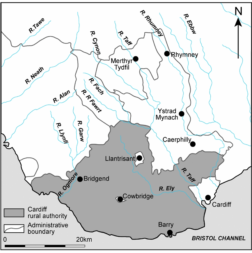
Moving beyond complaints brought before the Court of Chancery where river pollution cases were heard, this article draws on evidence from the Cardiff Union RSA to examine rural responses to industrial river pollution and the politics of prevention. The RSA was not a marginal backwater. Covering over 283 square kilometres (Figure 1), the Authority was located in a key region of industrialisation in northern Europe but was itself, in the words of Arthur Harris, Assistant Clerk to the RSA, ‘a purely rural area’ made up of small villages and scattered houses, ‘differing materially in its requirements from the populous places’.Footnote 10 Given the similarities between the South Wales coalfield and other industrialising regions in England and Europe, an examination of the impact of industrial river pollution on rural communities in the Cardiff Union RSA reveals the environmental problems faced by market towns, villages, and rural parishes from industrial development.Footnote 11 With the policing of river pollution in England and Wales subject to the same governance structures under the 1876 Rivers Pollution Prevention Act, a focus on the Cardiff Union RSA likewise provides the micro-contextualisation essential for understanding rural and regional responses to environmental problems. Furthermore, the Cardiff Union RSA was at the centre of regional efforts to limit industrial effluent and its impact on communities.Footnote 12
Map of Glamorgan.
Given that industrial nuisances ‘emerged gradually, in geographically particularized ways’, the article first explores the materiality of industrial waste in the region's rivers to show how polluted water was a damaging by-product of the South Wales economy.Footnote 13 From this examination of water, industrial waste, and the local rural environment, the discussion then turns to the politics of intervention. Central to this investigation are the conflicts that emerged – between the Authority and industry, between rural and urban authorities – conflicts that provide insights not only into practices of intervention, but also into the difficulties of working across administrative boundaries and the interconnections between rural, quasi-urban, and urban places. In the case of river pollution, disputes were not simply dramatic expressions of clashes between ‘muck’ and ‘brass’ revealed by studies of atmospheric pollution.Footnote 14 Instead, they reflect the complex patterns of intervention that characterised rural responses to industrial river pollution. Conflict was the result of how pressure and coercion could be integral at a local and regional level to efforts to regulate the rural environment – practices seldom acknowledged in accounts that have framed the activities of sanitary authorities as ineffective. This lack of passivity challenges the argument that responses to river pollution merely displaced, rather than confronted the problem of pollution, and that industry was always successful in limiting regulation.Footnote 15 Equally, an analysis of the Cardiff Union RSA's strategies to curb industrial river pollution extends our understanding of how rural sanitary authorities worked and how communities turned to rural authorities to clean up the rural environment. Further, by considering the complaints sent to the Authority, the article highlights how narratives of environmental and sanitary reform need to pay closer attention to how community concerns supported or guided rural authorities in their actions. Finally, the article examines whether any tangible environmental benefit resulted from these activities. In these ways, the article argues that the micro-politics of prevention reveal how we need to rethink the weak role of rural authorities in regulating the environment.
Pollution, industry, and Glamorgan's rivers
Rivers and streams were crucial components in supplying water to urban and rural settlements and industries in England and Wales. However, with limited underground sources of water in Wales, many rural communities relied on rivers, streams, and surface water from upland areas. In Glamorgan, ‘irregular and changeable’ geological formations made these sources of water particularly important, as access to reliable supplies was often problematic.Footnote 16 Yet rivers served a dual role in the nineteenth century: they were significant sources of water and places to discharge sewage, industrial and other forms of waste. It was common for towns and villages to dump their sewage, domestic ashes, and slop water into local watercourses or ditches that ran into them. Writing about rivers in Glamorgan in 1878, the South Wales Daily News explained how the Rivers Taff and Rhondda acted ‘as a common receptacle for all the accumulated filth of this district’.Footnote 17 Sewage in local watercourses did generate concern: urban boards of health complained about sewage from growing colliery communities, while rural sanitary authorities focused on localised problems caused by polluted groundwater from cesspits and waste from privies entering streams. However, the relative size of many urban and rural settlements in the region, and the limited number of sewerage schemes until the 1900s, ensured that levels of sewage in the region's rivers were felt, at least until the late 1880s, to be ‘practically so inconsiderable’ as not to overwhelm local watercourses.Footnote 18 For instance, in the market town of Cowbridge, only a ‘small proportion of sewage . . . from about 25 closets’ was emptied into the River Shaw, while most rural communities in the region were not close to (or downstream of) large urban populations.Footnote 19 Likewise, the impact of agricultural practices on watercourses was small scale and generated only periodic complaints about ‘animal refuse’ draining from farms into local streams.Footnote 20 Far more serious for rural communities was the problem of industrial pollution in a region where local watercourses drained ‘a district of enormous industrial and manufacturing importance’.Footnote 21
The material effects of industrial waste on the region's watercourses offer insights into the impact of heavy industry on rural regions. With a rise in the number of mines and industries in South Wales, the surrounding countryside increasingly suffered from the effects of industrial pollution. Rather than prompting a sudden environmental disaster, local mines, metal works, and other industries produced ever-larger quantities of wastewater, which they dumped into local watercourses. As the South Wales Daily News reported in 1887, ‘On every hand the large collieries, and iron and tin manufactories and smaller industries along the banks of several streams, deposited their mineral matter and refuse of all kinds in and along the sides of the riverbeds.’Footnote 22 Wastewater from mines contained high levels of acidic sulphate of iron and coal tar, while coal washing to make small coal more saleable saw fine coal dust dumped into rivers, polluting river basins and local watercourses (Figure 2). More serious was the waste from tinplate and galvanising works, such as those near Machen, Whitchurch, and Llantrisant. Such works discharged large quantities of diluted sulphuric acid in the form of ‘waste pickle’, which turned waterways ‘perceptibly acid to taste’.Footnote 23 Creosoting works for the Taff Vale Railway Company and oil works at Pontypridd saw tar washings dumped into local rivers, while the expansion of the Ely Paper Mills led to high levels of chloride of lime discharged into the River Ely. Ash from furnaces used in a wide range of industrial processes went directly into rivers. As the size and nature of manufacturing intensified in South Wales, collieries and works interacted with their rural hinterlands and downstream rural communities in increasingly damaging ways.Footnote 24
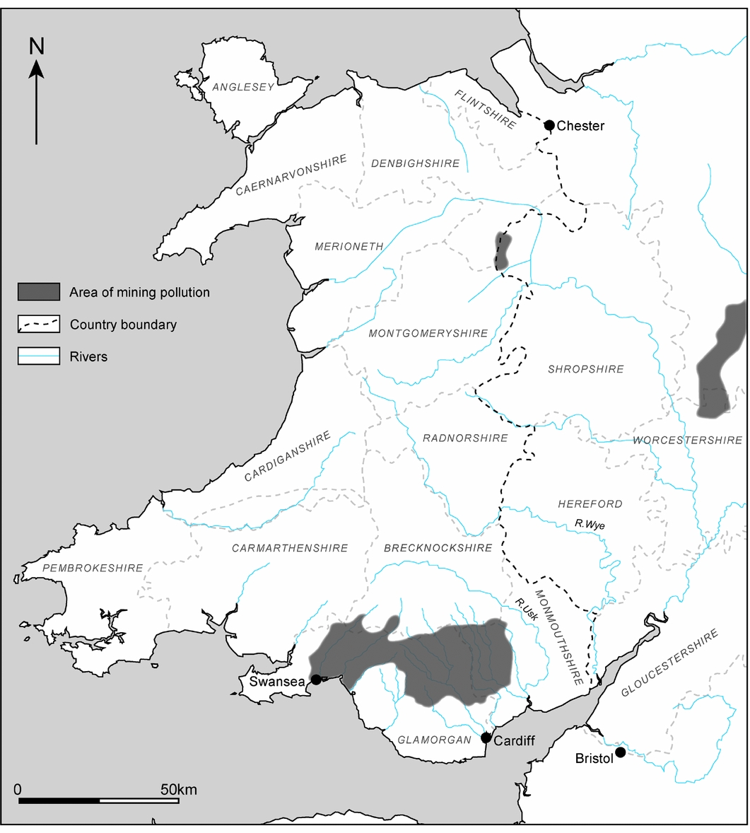
Sketch map of England and Wales showing river basins polluted by the mining industry.
While it is important not to read descriptions of environmental pollution as a priori evidence of alarm, the damaging effects of collieries, tinworks, and other industries on local watercourses were apparent to contemporaries, even if the impact of industrial effluent on rural communities downstream was difficult to quantify. As the Cardiff Times lamented in 1877, ‘It is clearly monstrous that the manufacturer should, for the purpose of his own private gains, cast into a stream of pure water’ that which spoils ‘the water for domestic use’.Footnote 25 This spoiling or contamination was evident through its visible signs, which had a clear physical dimension linked to the materiality of place in terms of colour and smell as measures of toxicity. An investigation of the River Rhymney by William Fraser, the inspector of nuisances for the Cardiff Union RSA, drew attention to the tell-tale signs of ‘very serious’ pollution from multiple sites of coal washing by citing the fact that the river was ‘as black as ink’ as evidence.Footnote 26 Pollution from gas works at Maerdy and Pontlottyn was visible through the way in which the river was ‘quiet yellow all the way to the sea’.Footnote 27 Reports on the River Rhondda described how ‘a vile and abominable mess of yellow colour’ from tinworks ‘stained’ the river. This ill-defined industrial effluent combined with waste from collieries, which included some of the largest at Fernhill and Dinas, to render the river ‘unfit even for cattle to drink’, whereas forty years earlier it had been ‘perfectly transparent’.Footnote 28 Reports on the River Taff focused on how waste from local tinworks turned the river brown, with the Western Mail commenting on how when the river was low it ‘stank very much from just such a smell as vitriol [sulphuric acid]’. For one correspondent in the Weekly Mail, the ‘black, murky water’ of the Taff was comparable to the River Styx.Footnote 29
Although reports stressed high levels of industrial pollution in the Rhondda, Taff, and Rhymney rivers, the chief focus of alarm in the region was the increasing pollution of the sluggish River Ely. Twice-weekly discharges from the Mwyndy mine made the river ‘a reddish yellow colour, and quite thick’, the result of chemical reactions produced by the discharge of acid mine-washings. Tinplate works along the Ely discharged sulphuric acid into the river, turning the water ‘distinctly acid’.Footnote 30 However, the main source of pollution came from the Ely Paper Mills: as the firm established itself as one of Britain's premier paper manufactures, the amount of liquid refuse discharged from the mill rose significantly. Reports drew attention to how the mills dumped ‘several hundred tons of a similar consistency to very dirty soap’ in the form of chloride of lime, along with other ‘liquid refuse’, into the river ‘day and night’.Footnote 31 Findings from an examination of the Caerau Brook reported in the Western Mail in 1890 revealed that the paper mills sent down ‘forty times the quantity of more poisonous stuff’ into the River Ely than discharged from local sewers.Footnote 32
High levels of industrial waste overloaded the capacity of local watercourses for dilution and purification. Evidence to the Rivers Pollution Commission from South Wales in 1868 emphasised how ‘[t]here are some hamlets and villages which have had no other water supply than that which is liable to these acid pollutions’ from local industries.Footnote 33 In 1880, local inhabitants wrote to the Cardiff Union RSA explaining how when the River Rhymney overflowed its banks the resulting sediment was ‘poison’ to the surrounding land.Footnote 34 By 1885, water in the River Ely was considered so polluted by industrial waste that the South Wales Echo reported that ‘cattle refused to drink it’. Arthur Harris, clerk to the Cardiff Union RSA, explained how water in the river had become ‘deleterious to life’ and ‘to the public health generally’.Footnote 35 Those living in rural communities were hence clearly worried about the scale and damaging effects of industrial waste and its ability to contaminate river water. Responsibility for tackling this pollution, as George Halliday, clerk to the Board of Conservators of the Taff and Ely rivers, explained to the Western Mail, ‘rests with the rural sanitary authority’.Footnote 36
Rural sanitary authorities and river pollution
Rural landholders were not helpless against the actions of town authorities over sewage pollution. Neither were rural sanitary authorities when it came to industrial waste. Following investigations between 1865 and 1874 by the Rivers Pollution Commission, the 1876 Rivers Pollution Prevention Act extended legal protection for Britain's rivers beyond existing nuisance laws. Responsibility for policing river pollution rested with local urban and rural sanitary authorities, which acquired powers to enforce provisions ‘in relation to any stream being within or passing through or by any part of their district’ provided they had consent from the LGB. Although the Act was mainly concerned with sewage, Part III covered industrial waste, with Section Four making it an offence to permit any ‘poisonous, noxious or polluting’ matter that degraded the water to be discharged from a factory or mine.Footnote 37 However, as Leslie Rosenthal explains in her nuanced reading of the Act, categories such as ‘poisonous’, ‘noxious’, or ‘polluting’, and standards of water quality were not defined. Concerns about the cost and potential effects of intervention on industry ensured that the Act sought to protect manufacturing interests: a clause permitted industries to discharge effluent if they could claim that they had used ‘the best practical and reasonably available means’ to render it harmless. For Anthony Wohl, the 1876 Act placed clean water second to industry.Footnote 38
Although framed by legal scholars as a flawed but well-intentioned law that established a crude precedent for intervention, contemporaries were critical of the 1876 Act. By the turn of the century, commentators were pointing to its failure, an assessment accepted by historians. The key problem lay in the policing role assigned to sanitary authorities. Existing studies suggest that the Act remained little used, and that it was actually the creation of county councils in 1888 that saw effective action start to be taken as they took responsibility out of the hands of ineffective local bodies.Footnote 39 However, if the 1876 Act often tied the hands of sanitary authorities, an examination of English legal actions only tells part of the story. A different pattern emerges from the minutes and letter books of Cardiff Union RSA, one not recorded in the twenty-six successful legal actions under the 1876 Act. Enforcement and compulsion were not just about legal proceedings, but also about how sanitary authorities adopted strategies to ensure industries took measures to limit pollution through surveillance, fines, and coercion.
Following the 1872 Public Health Act, sanitary legislation was applied to rural areas and rural sanitary authorities were established under the control of existing Poor Law boards of guardians. The Cardiff Union quickly responded to the act and set up a rural sanitary authority. Made up of forty-five parishes in Glamorgan and a small part of Monmouthshire, the RSA had a population of 17,888 by 1890. Although the region was to become highly urbanised, throughout the 1870s and 1880s reports consistently highlighted ‘the greater proportion of agricultural lands’ in the district and how industry co-existed with ‘purely rural’ areas, small villages, and scattered houses. Even the more heavily industrialised parishes in the district retained a strong rural character.Footnote 40
Responsibility for sanitary reform in the RSA rested with the Poor Law guardians elected by ratepayers in the predominantly rural parishes that made up the district, first under the leadership of Robert Oliver Jones, chair from 1871 to 1886, and then Robert Forrest, chair until 1894. Jones, who lived in the Vale of Glamorgan, was widely respected in the county: a Conservative in politics, he served as chair of the Glamorgan Quarter Sessions, stipendiary magistrate for Cardiff, and chair of the Cardiff Board of Guardians. His successor Forrest was the estate agent for the Earl of Plymouth and was well connected to commercial enterprises in Cardiff and Glamorgan, serving as director for a number of mining and rail companies.Footnote 41 Under Jones's energetic leadership and Forrest's business-like approach, the RSA took a keen interest in sanitation. With rural areas having attracted little sanitary attention before 1872, the RSA initially concentrated on tackling ‘heaps of all kinds of rubbish[,] defective drainage[,] small and badly ventilated homes’, and the proximity of pigsties to rural dwellings.Footnote 42 Once the most glaring nuisances caused by overflowing cesspits, pigsties, and polluted wells had been remedied, interest shifted to improving rural water supplies. As F. W. Granger, the Authority's Medical Officer of Health (MOH), explained in his 1879 annual report, rural communities ‘ought’ to be provided with the same quality water as towns as pure water was ‘the first and most important step in sanitary reform’.Footnote 43 Convinced by these arguments, and acutely aware that water in rural communities often represented a fragile resource, subject to contamination, the Authority invested in local water supplies. It was in the context of these efforts to improve water supplies that members of the Cardiff Union RSA started to become alarmed about the pollution of the county's rivers.Footnote 44
Although the Cardiff Union RSA was not embroiled in the sort of complex legal wrangling associated with complaints before the Court of Chancery about sewage pollution, three months after the 1876 Rivers Pollution Prevention Act came into force, the Authority decided to investigate the state of the county's rivers. The 1876 Act had prompted debate in the Welsh press about river pollution, but it was the Authority's decision to use water from the River Ely to supply Llandaff parish that provided the immediate context for the RSA's interest.Footnote 45 At the March 1878 meeting of the Authority, the two nuisances inspectors were instructed to ‘carefully note any infringement’ of the 1876 Act. Their reports were discussed a month later: in the face of the ‘serious evils shown to exist’, the Authority felt that it was not reasonable for rural communities to put up with the harm resulting from industrial pollution.Footnote 46 Speaking on behalf of the Authority two years later, the RSA's clerk William Stephenson told local manufacturers at a meeting at the Royal Hotel, Cardiff, that sanitary authorities had a ‘duty of preventing pollution’. As Stephenson explained, members of the RSA were therefore ‘determined to exercise their powers’.Footnote 47
The 1876 Act framed the RSA's growing intrusiveness in policing river pollution, as it, rather than individuals or groups of neighbouring landholders, took action to coerce manufacturers and collieries into adopting less environmentally harmful practices. Concern about local water supplies, and an ongoing investment in water infrastructures, ensured that the question of industrial river pollution was repeatedly brought before the Cardiff Union RSA between 1878 and 1890. As river pollution became part of the Authority's routine of intervention, the RSA sought regular advice from the LGB. Whereas the LGB favoured conciliation and expressed ‘no opinion as to the sufficiency of the measures adopted for dealing’ with industrial effluent, the Authority adopted a more strident tempo of action.Footnote 48 In October 1880, local metal manufacturers were told that ‘no black or white pickle [acid waste] would be allowed to be discharged into any of the Rivers’. All tinplate now had to be dipped in water troughs, with the water boiled down afterward to remove the acid, and retaining walls built along riverbanks to prevent ashes and other waste from entering local waterways.Footnote 49 While what was expected from other industries was not spelt out in the RSA's minutes or correspondence, companies came under increasing pressure from the Authority to abate nuisances and make improvements. Individual works were subject to surveillance and the RSA's minutes point to a distrust of owners to limit pollution. With the formation of Glamorgan County Council's Fisheries and Pollution of Rivers Committee in 1890, responsibility for policing river pollution passed to the county council. However, the Authority's role did not end there. Having built up experience of confronting industrial polluters, the RSA continued to apply pressure on the county council to investigate and prosecute polluting businesses.Footnote 50
Negotiation across borders
When he began his 1890 investigation into the extent of pollution in the Rhymney, Taff, and Ely rivers, Fraser needed to start twenty-five miles north of Cardiff at the Rhymney Coal and Ironworks. As his findings emphasise, political boundaries meant nothing to the material flow of pollutants and this partly shaped rural authorities’ ability to tackle industrial contamination. Industrial river pollution in South Wales was transregional, crossing the borders of rural and urban sanitary authorities. Not only were the main sources of pollution of the River Ely just outside the Authority, but ashes, refuse, and coal washings were regularly tipped into the River Rhymney ‘from the Monmouthshire side’. Just as rivers flowed through various sanitary authorities and over the boundaries of urban and rural authorities, some industries spanned districts: for instance, by the 1880s, the Ely Paper Mills had expanded partly into the County Borough of Cardiff and partly into the Cardiff Union RSA.Footnote 51 Such developments created added complications when it came to regulation.
The flow of river pollution across authorities and jurisdictional borders highlights both the permeable boundaries between rural and urban public health and the need for co-operation, not only between sanitary authorities, but also at the boundaries of the rural and the urban. From the outset, the RSA was acutely aware of the need to negotiate with other sanitary authorities because many of the causes of industrial river pollution were ‘beyond the limits of the union’.Footnote 52 Throughout the 1880s, Stephenson (until his death in 1885) and Harris repeatedly corresponded with urban and rural sanitary authorities asking for ‘common action’ against industrial pollution or requesting they prosecute known polluters. The resulting negotiations reveal the difficulties encountered in preventing pollution, especially when it came working with urban boards of health, which had different agendas or constraints on them. Instead of finding support, their requests frequently met with inaction or resistance from urban authorities. Although the RSA could secure cooperation from the Penrith Local Board over small-scale industrial pollution in River Petteril, other urban boards of health stalled or refused to act.Footnote 53 For instance, the Ystradyfodwg Board of Health in the Rhondda Valley wrote saying that, while it was aware of pollution from local collieries, as a recently formed board it felt that it was not strong enough to tackle local industries. Mountain Ash Board of Health showed a measure of self-awareness when it noted that it was in no position to protest against industrial polluters when it too was an offender.Footnote 54
If these responses frustrated the Cardiff Union RSA, the main source of conflict was with the Corporation of Cardiff, as it was at the boundaries of the rural and urban that negotiating action became most problematic. Initially, the Corporation was willing to cooperate over river pollution, especially over sewage in the River Rhymney. However, as the RSA turned its attention in 1879 to industrial waste in the River Ely, the Corporation felt that the ‘question’ of industrial pollution should be for rural authorities to decide. For the Corporation, industrial effluent in rivers was a rural issue.Footnote 55 Keen not to damage local industries, urban authorities were reticent to limit smoke and other forms of industrial pollution given the intimate relationship that existed between boards of health and industrial interests.Footnote 56 As the Ystrad Board of Health explained in 1887, ‘it would not do to kill the goose that laid the golden eggs’.Footnote 57 Primarily troubled by sewage pollution, particularly from the growth of settlements in the Rhondda Valley, the Corporation did not make explicit reference to the need to protect industry. However, having ‘shown such an enlightened desire’, according to the Western Mail, ‘for the prosperity and progress of its manufacturers’, the Corporation defended an important local industry through its repeated rejection of claims that Ely Paper Mills were ‘injurious to health’.Footnote 58 As the Corporation pursued delaying tactics, the RSA became increasingly dissatisfied, complaining to its urban neighbour that it needed to take action to prevent industries from polluting local rivers. In November 1886, a meeting of Cardiff Union RSA concluded that any negotiation with the Corporation was ‘quite useless’. The assessment was justified: increasingly the Corporation worked to block the RSA's efforts to reduce industrial waste in the River Rhymney and refused to cooperate over the Ely Paper Mills.Footnote 59
The extent to which the inaction and resistance encountered by the Cardiff Union RSA reflected ingrained political, social, and economic concerns is unclear. What opposition does reveal, however, is that because water flowed through authorities and across administrative boundaries, the sources of industrial river pollution were difficult to remedy between sanitary authorities. When it came to environmental pollution – whether from sewage or industrial waste – it was on the margins of the rural and urban, not downstream, that negotiations between sanitary authorities most frequently broke down, as different interests came into conflict.
Inspectors and communities
Central to the RSA's efforts to limit river pollution were the activities of the two nuisances inspectors: Thomas Williams, a former builder and inspector of nuisances for the northern part of the region between 1872 and 1888, and after 1888, William Fraser, the newly-appointed surveyor and inspector of nuisances. Narratives of urban public health have often focused on the work of MOHs and boards of health, but as Tom Crook and Christopher Hamlin reveal, urban nuisances inspectors were central to the day-to-day administration of public health. Their inspections acted as a means of surveillance and intervention.Footnote 60 While rural nuisances inspectors did not deal with the same volume of work as their urban counterparts, they were not the ineffective agents of reform that contemporaries characterised them to be. Instead, they were active in the mundane detection and remediation of nuisances. In the case of river pollution, Williams and Fraser were more than the underlings of the MOH. They reported directly to the RSA, with Williams later noting how he ‘enjoyed enormous discretion’ in his work: from his appointment, Williams was central to the Authority's efforts to improve water supplies and took the lead in many cases.Footnote 61 Williams and Fraser identified and reported on the causes of river pollution, and negotiated and enforced improvements, as they juggled what to tolerate, enforce, or condemn. While Williams was more strident and assertive in his dealings with managers, unlike urban inspectors, neither Williams nor Fraser appeared reluctant, cautious, or powerless when it came to dealing with industrial or ‘grand polluters’.Footnote 62
Williams's and Fraser's investigations and actions were not the whole story, however: local communities were active in pressing for reform. Sanitary reform has been framed as a top-down imposition, often fraught with tensions. Existing studies of river pollution have equally pointed to muted public concern and noted the role of powerful landholders or governing elites in the countryside in driving complaints. Furthermore, the views of middle-class reformers have dominated accounts of environmental concerns ensuring, as Stephen Mosley explains, that other voices appear too infrequently in studies.Footnote 63 Evidence from the minutes and letter books of the Cardiff Union RSA both challenge the elite character of complaints and give insights into these other voices. They show how parish councils, farmers, and tenants, rather than landed or fishing interests, were the main voices complaining about industrial effluent. Even if they did not set the agenda, they were not simply Ben Pontin's victims of industrial nuisances.Footnote 64 While this did not mean that they were unconcerned about the localised effects of sewage, they evidently viewed industrial pollution as a more pressing and material concern. The size of communities in the region ensured that pollution from drains, privies, or cesspits remained a localised problem that did not ‘overwhelm the natural processes of waterways to noxious and nauseous effect’ whereas industrial effluent did.Footnote 65 Furthermore, because those living in rural communities were more dependent on rivers and streams for water, they were more attuned to industrial waste than their urban counterparts who increasingly benefited from piped supplies.
The minutes of the Authority included references to frequent complaints about industrial effluent – in letters and in person to the nuisances inspectors – made by rural parishes and individuals living alongside or near the Rivers Ely, Rhymney, and Taff. For instance, at a meeting of the Cardiff Union RSA in September 1879, members heard how ‘residents in the neighbourhood’, many of whom were employed in local works, were making complaints about the ‘noxious liquids flowing’ into the River Ely from the Ely Paper Mills Company where production had grown considerably since its foundation in 1865. George William of Llanrumney called upon the RSA to take ‘stringent measures’ to prevent pollution of the River Rhymney, bringing a bottle of water that was ‘very brown, quite opaque, and full of sediment’ to a meeting of the Authority to press home his case.Footnote 66 Others wrote to the RSA in support of ‘the effort now being made to prevent’ river pollution, pressing the Authority to be more restrictive.Footnote 67 In the face of persistent complaints, the Authority was keen to project the image that when it came to industrial pollution it was not being vindictive, but was working to protect ‘the inhabitants of the surrounding districts’.Footnote 68
Whether complaints reflected Nimbyism or were a response to the Cardiff Union RSA's work is unclear, they do reveal the local inhabitants’ increasing sensitivity to the industrial contamination of local watercourses. As one letter-writer to the South Wales Daily News lamented, ‘Why such horrible stuff as vitriol [sulphuric acid] should be allowed to be turned into the Taff from some of the works up the river is a mystery to me.’Footnote 69 For some, industrial river pollution prevented amenity and the enjoyment of leisure pursuits, such as fishing and rowing. Members of the Taff and Ely Rod Fishing Association were alarmed about the decline of fish in the two rivers and pressed rural authorities for stricter pollution controls. Throughout the 1880s, the Association worked with the Cardiff Piscatorial Society to encourage the Cardiff Union RSA to intervene against the Ely Tin Plate Works at Pontyclun. The Cardiff Amateur Rowing Club was equally worried that levels of sulphuric acid in the River Taff from tinplate works prevented the enjoyment of the river.Footnote 70 The most vociferous complaints, however, came from those in living in rural communities along or near contaminated rivers, who saw the danger of industrial river pollution in health terms. Complaints from rural communities reflected a sense that industrial effluent rendered river water, in the words of the Western Mail, ‘absolutely unfit for human use’.Footnote 71 For instance, Augustus Morgan, rector of Machen, explained how ‘[t]he River [Rhymney], I am sorry to say, is at present in such a state’ that his parishioners ‘can make no use of it, either for culinary purposes or washing clothes’. In expressing alarm about industrial waste, those living in rural communities asserted that river water was noxious and ‘very injurious for drinking purposes’.Footnote 72
While evidence in letters to the RSA and articles in the press does not support the view that anti-industrial sentiments drove complaints, objections from rural communities do highlight how those affected increasingly turned to sanitary authorities for a solution. This willingness might reflect the high cost (roughly £500) of obtaining a judgement in the Court of Chancery, which made the prospect of a common-law remedy unrealistic for many. Importantly, however, complaints indicate how rural communities came to view and use rural sanitary authorities. Evidence from correspondence between the LGB and rural authorities suggest that these were not isolated cases of local communities turning to sanitary authorities.Footnote 73 Not only did rising living standards and the pursuit of respectability bring with it rising expectations, but also demands on rural sanitary authorities increased as individuals and communities felt they should enjoy, as one local resident told the RSA, certain benefits ‘for contributing a substantial yearly sum’.Footnote 74 Complaints point both to how rural parishes and villages expected rural authorities to act on their behalf and to a growing sensitivity to industrial pollution as ‘unnatural’.Footnote 75 For instance, whereas the insanitary practices of rural communities had been a matter of alarm in the early 1870s, by 1880 the same communities had become active in their demands for industrial river pollution to be tackled, as discourses of ‘safe’ and ‘clean’ water took hold and local, place-based practices were labelled harmful. Evidence to the Royal Commission on Land in Wales and Monmouthshire equally drew attention to how changing attitudes to hygiene were encouraging ‘a bolder outspokenness in insistence on the necessity of carrying out’ improvements to water supplies.Footnote 76 If complaints about industrial river pollution drew on a range of concerns, running through them was an expectation that it was the responsibility of rural authorities to protect local water supplies. While an earlier section offered a broad outline of how the Cardiff Union RSA responded to industrial river pollution, the final section maps out the politics of intervention and how the Authority sought to protect rural communities.
‘You will take all necessary measures’: the politics of control
Existing studies have emphasised how urban sanitary authorities as major polluters of rivers themselves often failed to act or, as illustrated by the attitudes of the Corporation of Cardiff, obstructed efforts to tackle river pollution. They highlight how the legal remedies under the 1876 Act were inadequate and rarely employed.Footnote 77 Evidence from the Cardiff Union RSA suggests a different pattern that bears little resemblance to the impotent, backward bodies described by contemporary critics of rural administration and historians. What the minutes and letter books reveal about the micro-politics of rural responses to industrial waste demonstrates active practices of control. They show how surveillance, demands, fines, and threats of legal action, with legal proceedings as a last resort, provided strategies for intervention to force local industries to limit river pollution.
Individual works became the focus of coercion as sites along the largest rivers in Glamorgan – the Ely, Taff, and Rhymney – came under surveillance. The resulting investigations of individual works delineated a series of interconnected sites of pollution that defined whole rivers as polluted. Observational evidence from Williams and Fraser was fundamental to these efforts in part because the precise amount of ‘poisonous ingredients’ in rivers deemed injurious to health was uncertain. As Christopher Hamlin explains, questions surrounding the purity of water drew on a ‘common-sense standard’: with quantitative evidence produced through chemical analysis being both liable to fluctuate and be contested, appearance, smell, and taste were essential components of identification.Footnote 78 The determination of the level of industrial waste in the region's rivers and the perceived dangers to health were therefore about embodied empiricism, observation, and the senses. Chemical analysis played a secondary role and river water was only subject to analysis when works challenged observational evidence from Williams or Fraser.Footnote 79 By the late 1880s, this reliance on appearance, smell, and taste was supplemented with findings from Fraser's experiments with minnows to confirm whether water was polluted or not. Minnows offered convenient and understandable experimental subjects. Placing them in jars of water from suspected sites of pollution, Fraser reported on the number of minutes they could survive. If not warranting concern or empathy, their deaths were evocative. The resulting evidence of how long the minnows survived in water samples produced easily quantifiable findings that were accepted by the RSA and managers alike as an accurate indication of levels of pollution.Footnote 80
Although the LGB was statutorily required not to sanction river protection measures unless it was satisfied that intervention would cause ‘no material’ injury to industrial interests, the RSA became increasingly forthright in its complaints against owners and managers and in its demands for them to limit pollution. Based on evidence from Williams and Fraser, and on complaints from those living in affected communities, polluting works were bluntly given a month to start taking measures to reduce the amount of industrial effluent they discharged, in order to avoid ‘the unpleasant necessity’ of orders or proceedings against them.Footnote 81 This was a harsher stance than that favoured by the LGB, which recommended anything from two to six months between the issue of notices and the start of proceedings.Footnote 82 This pressure, couched in a language of demand and coercion, was often effective. Furthermore, it removed the need for legal proceedings: for instance, after initially denying that the Tir-Phil Gas Works drained its gas washings into the River Rhymney, the manager Mr Thomas gave into pressure and ‘promised to stop the pollution in a week’.Footnote 83 However, whereas national inspectors responsible for regulating industrial pollution tended to view manufacturers as respectable and trustworthy, members of the Cardiff Union RSA were more sceptical. The 1876 Act allowed firms to claim that they had adopted the ‘best practical and reasonable available means’ to limit pollution, but this was often not enough for the RSA.Footnote 84 Even when managers claimed that they had taken all reasonable or practicable methods, the RSA did not seem satisfied and pressed for further measures.Footnote 85
In insisting that works should limit pollution and adopt cleaner production methods, the RSA came into repeated conflict with individual companies. These conflicts were not sudden or framed by legal interventions, but a feature of the continuing process of surveillance and intervention. Managers and owners used meetings with Williams and Fraser and their correspondence with the RSA to reject claims that their works were causing contamination. For instance, in response to a series of investigations by Williams, Thomas W. Booker & Co., owners of Melingriffith works, wrote to the Authority to explain that they were not liable under the 1876 Act. They claimed a prescriptive right to deposit ashes on the banks of the river as the practice had been going on for years. The company complained that Williams's report would have read differently if he had ‘taken the trouble to see our Mill Managers’ who, the company claimed, were under ‘strict orders that any noxious mater should not pass from these works into the river’. Where such comments highlight how owners often appeared unaware of what was happening at their works, claims by Booker & Co. that discharges from their works were ‘perfectly innocuous’ echoed protests by other manufacturers in Glamorgan and elsewhere in Britain.Footnote 86 If the Rivers Pollution Commission felt that existing technology was available to mitigate industrial pollution at an acceptable low cost, the basis of rejecting the RSA's claims was often financial.Footnote 87 With a depression in the tinplate trade, the owners of the Melingriffith works were keen to distance themselves from accusations of pollution, worried about the ‘very serious expense’ entailed in addressing the problems identified.Footnote 88 Likewise, Mr Jones, the acting manager of the Treforest Iron and Tin Plate Works, explained how it was ‘a very difficult matter to dispose of the acid [from the works] in any other way as the manufacture [from waste acid] of copperas [for inks and dyes] did not pay’.Footnote 89 Given the high levels of contamination in the Ely, Taff, and Rhymney rivers, firms no doubt felt that there was little incentive to reduce their own discharges when there was no immediate benefit to them, an argument repeated by many British firms.
Whereas the LGB favoured enforcing minimum standards through conciliation, the minutes of the Authority's meetings reveal how the patience of the RSA quickly wore thin. Claims about the financial cost of improvements elicited little sympathy.Footnote 90 The RSA was prepared to threaten and then start legal proceedings when manufactures failed to act or where the Authority believed they had been negligent in making improvements. This pattern of activity was established from the outset. Jones, as the RSA's chair and chair of the Glamorgan Quarter Sessions, pressed for a firm stance against Booker & Co. for continuing to overlook the fact that ‘poisonous and noxious liquids’ from their Melingriffith and Pentyrch works were being dumped into the River Taff. In preference to negotiation, Jones felt that the matter should be put before a magistrate. Despite Thomas Booker being a member of the RSA, a well-attended meeting of the Authority agreed with Jones and it was decided to seek an order from the County Court requiring Booker & Co. to abstain from polluting the Taff.Footnote 91 How much this was a symbolic act to demonstrate to other polluting works the need for action is unclear. Certainly, the LGB advised against such proceedings, believing works would make improvements. However, what is clear is how by the early 1880s the RSA was becoming frustrated with the LGB for not investigating complaints and sanctioning action quickly enough. Rather than waiting, the Authority increasingly threatened manufacturers with fines of £200 and prosecution when interviews and warnings did not produce results. For example, the RSA used threats of legal action to coerce the Waterloo Tin Works to ‘take the necessary steps’ to prevent polluting liquid from being discharged into the River Rhymney.Footnote 92 After unsuccessful negotiations with the owners of the Ely Paper Mills to prevent ‘specific causes of pollution’, the RSA issued a summons in 1880. Although the Cardiff Quarter Sessions threw out the case, confident that the company would make improvements, the summons had an effect. The company promised to adopt a plan for ‘counteracting the effluvia’.Footnote 93 The coercive tactics used by the RSA through fines, threats of legal action, and cases brought before local magistrates produced results, forcing individual works to make improvements.Footnote 94
Boundaries of authority: conclusions
By the late 1880s, an increasing number of sanitary authorities in South Wales were becoming alarmed about the state of the region's rivers. If urban boards of health were more likely to be worried about sewage from growing mining communities, urban and rural authorities were directing more effort at ensuring local industries abated nuisances likely to cause river pollution. By 1896, the LGB was praising the work of Glamorgan County Council in tackling industrial effluent, but the creation of the council's Fisheries and Pollution of Rivers Committee in 1890 did not mark a change in policy. Glamorgan County Council and the subsequent joint committees it established with Monmouthshire and Carmarthen county councils continued the work of the RSA, which used its 1890 report on river pollution to put pressure on Glamorgan County Council to take the issue seriously.Footnote 95 Fraser continued to provide reports on the state of the region's rivers and was involved in the work of Glamorgan and Monmouth county councils’ Rhymney River Joint Committee.Footnote 96
Rather than county councils succeeding where the Cardiff Union RSA had failed, or local works being successful at blocking efforts to limit the waste they discharged, between the 1870s and 1890s the extent of contamination in South Wales’ rivers increased dramatically. The waste-intensive growth of industries in the region became too widespread to allow for easy solutions, especially as pollution accumulated over time. In the face of growing levels of industrial waste, the Cardiff Union RSA could only curb the polluting practices of individual works. Furthermore, it was hampered by the fact that much of the effluent discharged came from sources ‘whose mischievous influence on running waters of the district cannot be so easily prevented’.Footnote 97 As industrial river pollution pitted upstream against downstream users and transgressed boundaries, the RSA's efforts to limit industrial waste at the local and regional levels highlight the difficulties encountered at the boundaries of sanitary authorities and in securing cooperation, especially on the margins of the rural and urban. While this demonstrates the problem of regulation across the borders of sanitary authorities – something often overlooked in accounts of the urban environment and public health – it also draws attention to how rural authorities were not always peripheral to an urban metropole. As such, their responses to industrial pollution need to be more fully incorporated into our understanding of attempts to regulate the environment.
At a regional level, the Cardiff Union RSA's efforts to curb industrial river pollution reveal how rural authorities and communities, rather than just the owners of country estates or fishing interests, were concerned about levels of pollution that went beyond protests against urban sewage. For the Authority and for rural communities the presence of industrial pollutants in rivers was not a ‘necessary’ evil, but a source of alarm and focus of intervention. In the years following the 1876 Rivers Pollution Prevention Act, the RSA persuaded, cajoled, and coerced local industries to reduce the waste they discharged. Rather than the LGB's policy of compromise and negotiation, the Authority used threats, fines, and the powers available under the 1876 Act to reduce industrial river pollution when either negotiation failed or works did not act fast enough. Hence, instead of passivity and compromise, the Authority drew on a range of strategies to target sites of pollution identified through embodied empiricism and complaints from rural communities. This markedly contrasts with a narrative of negotiated compliance that other historians have seen as ‘common to nineteenth-century state agencies in order to confront the conflicting demands of national economic prosperity, individual liberty, and environmental necessity’.Footnote 98 Under pressure, industrial works and mines in the region appeared increasingly willing by the mid-1880s ‘to adopt any plan that may be suggested’. The solutions adopted were simple ones: retaining walls along riverbanks were built; settling tanks for coal washings or to turn acid waste into marketable copperas were installed or repaired; pumping machines to reuse wastewater were installed; and repairs were made to defective machinery identified as causing pollution.Footnote 99 Although there is no evidence to suggest this was done to avoid legal action or compensation, individual works promised that they were ‘leaving no stone unturned’ to meet the Authority's requirements, even if they continued to challenge claims that they were polluting the region's rivers.Footnote 100
Moving the focus from legal cases to the micro-politics of prevention reveals different patterns. These patterns highlight the need to examine what was happening not just in the courts, but on the ground or along riverbanks. Although the scale of the problem was too great to remedy until new methods and technologies of intervention became available in the 1960s and 1970s, such findings show how our assumptions about the weak role of rural sanitary authorities – in this case in regulating industrial river pollution – need revision. Equally, they highlight how ideas about the urban as the starting point for the regulation of the environment needs to be reframed, and how the rural offers another starting point for rethinking and complicating existing narratives of reform as well as the processes of intervention. Furthermore, these findings reveal how industrial pollution, not just urban sewage, could provide an active arena for intervention, especially in rural areas. Finally, they demonstrate how power relationships did not always favour industrial interests, and how coercion and the threat of prosecution resulted in industrial practices being modified and environmental benefits.
Acknowledgements
In researching and writing this article, I would like to thank Deborah Barton, Anne Hardy, Martin Johnes, Antonia Layard, Anthony Mandal, and Mark Williams for their generous support and comments. I am also grateful to those who commented on a version of this article at the SSHM 2016 biannual conference, as well as the anonymous reviewers for Rural History.


 Open access