


Introduction
In 1977, Wilhelmina Jashemski excavated the Shop-House Garden (I.20.5) in Region I of Pompeii. In her report, Jashemski noted that the garden space had once been occupied by a building that was demolished following damage from the earthquakes that hit the region from 62/3 CE onwards. Various features in the garden led her to this conclusion: wall frescoes intended to decorate interior rooms were discovered on internal garden walls, partial walls from demolished rooms were discovered jutting into the garden, and a new cistern had been installed in front of a blocked door.Footnote 1 Root cavities uncovered in the garden showed that it was intensively cultivated with young vines, trees, and potentially vegetables in 79 CE, justifying the installation of a new cistern. Jashemski went on to identify two further gardens, VI.5.7 and VIII.6.5, built similarly in the space of buildings demolished after 62 CE, but stopped before undertaking a broader analysis.Footnote 2
Domenico Esposito and Fabrizio Pesando have subsequently commented on the phenomenon of new productive gardens in the city’s history and the apparent relationship between urban legal measures and the creation of garden space.Footnote 3 Yet, to date, no attempt has been made to identify, map, or typify this type of garden in the city, nor to explore the motivations behind the gardens’ creation, such as economic opportunity, crisis response, or shifting consumer trends. Building on Jashemski’s research and that of Esposito and Pesando, this article presents the first attempt to identify, map, and create a typology of urban agricultural gardens in the city, including gardens which I refer to here as opportunistic gardens. I define opportunistic gardens as those cultivated or restructured after the earthquake of 62 CE to maximize the utility of urban spaces, reflecting economic or social adaptation. These include gardens established in the spaces left by fully or partially demolished structures, as well as gardens that show evidence of redefined or expanded use (e.g., the introduction of cash crops) within existing spaces to capitalize on post-earthquake recovery opportunities.
This investigation will enrich our understanding of the social relationships and choices of Pompeian society in space and will join recent studies that are moving away from siloed urban and rural perspectives to a view of Roman towns as fluid landscapes, defined by dynamic interactions and permeable boundaries between urban centers, peri-urban fringes, and the surrounding countryside.Footnote 4 Most especially, this analysis of a growth in urban agricultural production will contribute to an expanding body of scholarship that recognizes and promotes agricultural production activities in urbs.Footnote 5
Following the first quantification of opportunistic gardens in the city, I will demonstrate that the 24 gardens created in Regions I and II during the final 17 years of the city’s existence were, first and foremost, an opportunistic response by local businesspeople and landowners to growing economic and real estate prospects, and secondly, a resilient response to an ongoing period of crisis in the town, defined by natural disasters and famine. Following an outline of the methodology used to identify opportunistic gardens and the data resulting from its application, this study will consider the repercussions of the phenomenon of a rapid growth in working gardens for our understanding of the city’s economy and operation in its final years. In assessing variables such as land ownership and rental, I attempt to set the groundwork for further investigations into who was responsible for garden construction and maintenance, and what impact their changes were intended to have upon the local community.
Historical background and methodology
The development of Regions I and II
This study is based upon an autoptic and comprehensive analysis of open spaces across all nine regions of Pompeii, employing the methodology that I will outline below. This initial survey revealed a distinct concentration of urban agricultural gardens in the southeastern corner of the city, in Regions I and II (Fig. 1). Given this pattern, I selected these regions for a more focused investigation into the gardens’ function and operation. Understanding the historical development of this neighborhood provides critical context for why these transformations occurred there in the mid-1st c. CE.
Map of Pompeii, showing the unexcavated areas in grey. (J. Venner.)

Regions I and II, enclosed by the Via Stabiana (running north–south) and the Via dell’Abbondanza (running east–west), were originally agricultural land before undergoing phased urban development between 300 and 180 BCE. Like much of the area outside the Altstadt, this district was initially occupied by scattered agricultural buildings and used for small-scale farming. The land divisions here resemble heredia, defined and inheritable plots of regular size, of the kind described by Varro.Footnote 6 This suggests that, before urbanization, these plots may have functioned as agricultural allotments passed down through generations. The presence of wells beneath early structures further supports an agrarian origin.Footnote 7
In the period between 300 and 180 BCE, these plots were gradually built over by domestic, commercial, and industrial structures, transforming the district into a more densely occupied urban space. This process of urbanization accelerated after Sulla’s colonization of Pompeii in 80 BCE, when increased investment in workshops and hospitality venues reshaped the area’s economic landscape. The insulae in Regions I and II followed four distinct layouts, as identified by Hoffmann and Nappo (Fig. 2).Footnote 8 However, after the 62 CE earthquake, parts of Pompeii’s southeastern neighborhood appear to have reverted to agricultural use, suggesting a fluid and adaptive relationship between urban and rural functions throughout Pompeii’s history. This historical trajectory informs our understanding of post-62 CE transformations in Pompeii. Rather than representing a radical shift in land use, the emergence of agricultural gardens following seismic disruptions reflects a reversion to the area’s earlier function, driven by new economic and environmental pressures. This article argues that such a return to cultivation was neither anomalous nor unprecedented, but an opportunistic adaptation to crisis, one that built on the neighborhood’s historical relationship with agriculture and land use.
Reconstruction of the schemata for dividing insulae in Regions I and II into regular lots. (Per Nappo Reference Nappo, Laurence and Wallace-Hadrill1997, 349; Nappo Reference Nappo, John and Foss2007, fig. 4.)

Identifying opportunistic gardens
Agricultural gardens in Pompeii and across the Roman world were used to grow vines, fruit and nut trees, vegetables, herbs, and flowers, and on occasion also included production areas, such as treading floors or olive presses.Footnote 9 The types of properties this study focuses on were commercial and commercial-dining urban agricultural garden properties. I define commercial gardens as those geared towards the cultivation of food, drink, and other products for the market (the latter including, for example, perfume and garlands) and commercial-dining properties as garden spaces used for “al fresco” dining in tandem with food production on site, often with internal commercial areas (e.g., tabernae) attached to the garden space.Footnote 10 To map the agricultural gardens created or expanded after the major earthquake and critically analyze the micro-actions of landowners and gardeners in the city’s final two decades, I have adopted an architectural approach that is typically used in building construction analysis.
Using this approach, I identified blocked doors, demolished walls, and the addition of new (agricultural) features in open spaces. I complemented this data with supplementary micro and macro archaeobotanical evidence where possible, including root cavities (root diameters being an important indicator of age), pollen and seed or food remains, and material evidence, such as dolia, triclinia, irrigation systems, and cisterns. A further important consideration was the nature of access to a garden property. For example, direct access to a commercial-dining garden enhanced economic opportunities for owners or gardeners by increasing the visibility of serving spaces. Such visibility attracted greater interest from potential customers and encouraged them to enter the space. Similarly, the adaptation and development of “new” commercial garden space was often influenced by a garden’s location in the city and the ability to control access and manage the security of garden contents. Therefore, features such as blocked and new doors and direct access to garden properties can reveal who was entering the garden, and for what purpose (hospitality, garden maintenance, and so on; see below).
Table 1 sets out the archaeological features used to identify potential opportunistic gardens in Pompeii’s Regions I and II. Archaeobotanical remains can be used for this purpose, as can other supplementary features.Footnote 11 From there, a good starting point for identifying opportunistic gardens is the comparison of insulae floorplans with the four building schemata established by Hoffman and Nappo and seen in Figure 2.Footnote 12 Of course, this must be done cautiously, for changes very likely occurred after the initial layout of the insulae and before the earthquake, though the features in Table 1 can help narrow such changes down. This comparison allows the identification of property alterations that likely occurred due to the demolition, extension, or repurposing of structures in an insula after its initial layout (perhaps also in some cases for division and resale, which I discuss below). In addition, demolished walls and blocked doors leading onto, and in association with, agricultural garden spaces can be used to chart the structural development of properties in more detail and to better understand their commercial use in antiquity.Footnote 13
Conditions for identifying possible opportunistic gardens.

Finally, the aforementioned supplementary features, where available, can provide essential information about the function of opportunistic gardens and, in some cases, their age. Once a species has been identified, age can be determined by a root cavity’s diameter. Similarly, cisterns can indicate the presence of flowers, vegetables, or in some cases, young plants, due to the fact that established vines and trees do not require regular watering. Ramps found in association with an open space are also useful indicators of commercial activity.Footnote 14
Theoretical framework: the six tensions of urban resilience
Adaptive strategies of the kind discussed in this article are central to resilience theory, which considers how cities recover and evolve after major disturbances.Footnote 15 Generalized adaptability in the face of change, as well as the quick return of an urban system to a state of relative stability (akin to conditions pre-disturbance), are indicators of a resilient city.Footnote 16 Identifying structural modifications and supplementary features associated with garden spaces not only aids in determining the function and chronology of opportunistic gardens but also provides broader insights into patterns of urban adaptation. By extension, this analysis offers a valuable measure of Pompeii’s resilience in the face of crisis.
Almost all discussions of resilience favor generic adaptability to a broad range of possible disturbances over specific responses to shocks.Footnote 17 Following a review of decades of research into urban resilience, Sara Meerow, Joshua Newell, and Melissa Stults developed the following definition of the term:
Urban resilience refers to the ability of an urban system… to maintain or rapidly return to desired functions in the face of a disturbance, to adapt to change, and to quickly transform systems that limit current or future adaptive capacity.Footnote 18
In their study of the horticultural collectives established in vacant urban plots in modern Barcelona during high ongoing levels of unemployment, Marta Camps-Calvet and her team commented on the ability of urban agricultural gardens to contribute significantly to the resilience of an urban system during social and economic crises.Footnote 19 To illustrate this, they built on the model established by Carl Folke (“Mechanisms for nurturing resilience”) and named retrospection, collaboration, knowledge, and diversity as hallmarks of a resilient urban system.Footnote 20 While many of these principles of resilience can be recognized in modern bottom-up urban horticultural movements, they also contribute to a vision of how organic urban development improved the system of urban centers such as Pompeii.Footnote 21
Given the subjectivity of the measures of “resilience” in modern scholarship, especially in relation to consideration of a city’s return to a steady state, various models have been developed to summarize the characteristics of resilience in urban centers.Footnote 22 While these models are often intended to be implemented with foresight, most commonly in cities faced with climate change, they can also be usefully applied with hindsight to ancient cities such as Pompeii. For a retrospective view of Pompeii’s resilience levels in 79 CE, a broader framework is of use.
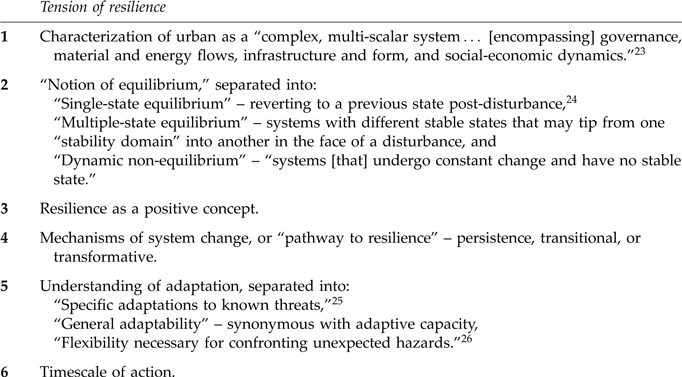
The “Six conceptual tensions of urban resilience,” developed by Reference Meerow, Newell and StultsMeerow, Newell, and Stults, is beneficial here (Table 2). This model was produced to answer the need for a central framework within which to better understand different cities’ responses to shock. Each “tension” represents alterations made within a system under stress and, as such, provides a criterion for assessing and producing more resilient social-economic systems. These “tensions” ask the researcher to consider temporality, generic adaptability, transition, and transformation when assessing the level of resilience of any social-economic system. Can post-62 CE Pompeii be considered a resilient city? Its conformity with the conditions of the six tensions suggests that it can.
Six conceptual tensions of urban resilience (per Meerow et al. Reference Meerow, Newell and Stults2016).

Pompeii can be seen to have functioned as a complex, multi-scalar system (Tension One) due to its layered socio-economic structures, diverse energy inputs, and integration into regional and intra-regional nundinae.Footnote 27 These interactions facilitated material and energy flows, sustaining economic growth and reinforcing the town’s positive resilience (Tension Three). In terms of equilibrium (Tension Two), Pompeii’s post-earthquake trajectory does not fit neatly into either a “single-state” or a “multiple-state” equilibrium model: Regions I and II did not return to their pre-seismic dense occupation patterns, nor did the city transition entirely to a new stable state.Footnote 28 While “stability” is subjective, the majority of the population seems to have been living in relatively favorable nutritional and economic conditions before the earthquake.Footnote 29 Rather than simply “bouncing back,” Pompeii’s development aligns more closely with a “dynamic non-equilibrium” model, which recognizes urban recovery as an ongoing process of adaptive shifts rather than a return to a fixed state.Footnote 30
Pompeii’s state of dynamic non-equilibrium created an environment in which diverse responses to shock emerged, including the development of new agricultural gardens and sustainable actions within them. In Regions I and II, this adaptability is evident in varied cultivation strategies and measures to safeguard buildings, common-pool resources (e.g., water, food), and income. To interpret these patterns, I apply a resilience framework that draws on the six tensions, helping to distinguish short-term adaptations from broader structural transformations.
Quantitative results
The application of this methodology to garden sites in all of Pompeii’s nine regions led to the identification of 47 urban agricultural gardens in total. These can be quantified as follows:
-
1. Thirty-five in Regions I–IX created or expanded after the earthquake of 62 CE (opportunistic gardens), indicating a surge in urban agricultural activity in the final years before the eruption
-
2. Twelve established pre-62 CE, all of which exhibit signs of having been purpose-built as agricultural spaces. These were either integrated into the original design of a domus, such as the walled rustic garden in the House of Menander (I.10.4), or exhibit evidence of longstanding commercial cultivation, as in the Large Vineyard (II.5).
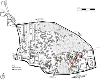
Of the 35 opportunistic gardens identified across Regions I–IX, 24 were found in Regions I and II alone (Table 3).Footnote 31 This demonstrates a significant concentration of, and growth in, agricultural activity in the southeastern part of the city post-62 CE.Footnote 32
Opportunistic gardens identified in Regions I and II, organized according to garden space access.

When plotted (Fig. 3), a cluster of new agricultural gardens can be seen in the insulae to either side of the Via di Nocera, almost exclusively in the nine eastern insulae of Region I and three western insulae of Region II. Productive gardens in this neighborhood are often accompanied by at least one other garden in the same insula. This cluster of opportunistic agricultural gardens aligns with the significant level of seismic damage suffered in the same area, increasing the likelihood that their presence was the result of that damage.Footnote 33
Opportunistic and pre-62 CE gardens mapped onto a plan of Pompeii. (J. Venner.)

By observing which garden spaces did or did not have direct access from the street, I was able to gain insights into concerns over security or customer footfall (commercial opportunity) (Table 3; Fig. 4). Notably, in all but two direct-access gardens, the primary product was vines (the exceptions being a small olive nursery with an outdoor triclinium at I.21.3 and the religious garden, also with a triclinium, at II.1.7A/11–12).Footnote 34 In the majority of properties without direct access to the garden space, other crops dominated, such as fruit and nut trees, vegetables, and flowers. This suggests that these crops, perhaps due to their higher market value, were deemed more worthy of protection than vines. Security therefore appears to be a central concern in properties without direct access to productive garden space. Likewise, for every commercial dining property in the sample with direct garden access and a permanent outdoor triclinium there was a clear view of the dining area from the street, suggesting a deliberate strategy to attract customers and boost profits. Many of these places were also located on or near main thoroughfares, often positioned strategically opposite exit points from public buildings, such as the Large Palaestra.
Opportunistic gardens with direct access to garden space from street (rings). (J. Venner.)

While the presence of unexcavated areas in the southern parts of Regions III and IX leaves open the possibility that additional gardens may refine the overall distribution pattern, the cluster identified in Regions I and II remains significant. The following case studies will apply the methodology outlined above to examine these gardens in greater detail, providing a deeper analysis of their function, structure, and broader implications for urban adaptation in post-62 CE Pompeii.
Qualitative results: case studies in urban adaptation
Case study 1: post-seismic reconfiguration of insulae
A bird’s-eye view of Region I reveals two irregularly shaped open spaces that stand out from the otherwise densely developed insula: the House of the Larario Isiaco (I.13.12–14) and the House of Lesbianus and Numicia Primigenia (I.13.9) (Fig. 5). Insula I.13 occupies a strategic position at the northwestern corner of Region I, at the intersection of major thoroughfares: the Via dell’Abbondanza, Via di Nocera, Vicolo dei Fuggiaschi, and Via di Castricio. This prime location provided excellent access for transporting goods both into the town and out through Pompeii’s gates, making it particularly well suited for trade. Despite differences in layout and accessibility between individual properties, the insula’s overall connectivity emphasizes its importance as a hub for economic activity.
Plan of Insula I.13, showing opportunistic gardens at entrances 9 and 12–14. (J. Venner.)

The House of the Larario Isiaco (I.13.12–14) is located on the Vicolo dei Fuggiaschi, where shallow wheel ruts point towards occasional cart traffic. A ramp at this property supports the idea that goods could have been transported directly onto this street. The House of Lesbianus and Numicia Primigenia (I.13.9) faces the Via di Nocera, a much busier thoroughfare leading to the Porta Nocera and the Via dell’Abbondanza. The deep wheel ruts along the length of this street indicate that wheeled traffic frequently passed by the entrance of this property, though no ramp appears there.Footnote 35
Following the earthquake of 62 CE, gardens in this insula were expanded, consuming portions of houses originally built to the Hoffman schema (Fig. 2). Approximately seven properties were either demolished or reduced in size to create larger garden spaces for cultivating cash crops.Footnote 36 To protect these new agricultural gardens and their produce, entrances to the gardens were blocked, preventing direct access from the street.Footnote 37 Given the absence of direct access, it is likely that these two gardens were used to cultivate crops other than, or alongside, vines, such as fruit and nut trees, flowers, or vegetables (see patterns between direct access and produce types in Table 3).Footnote 38
Unlike its commercial-garden neighbor, the garden at I.13.12–14 incorporated the converted domestic property (perhaps for storage) and taberna at the front. The area at entrance 14 appears to have been used for storage and stabling, due to the trough in the northwest corner and the ramp at the entrance.Footnote 39 This wide entrance is one of the 36 ramps identified by Poehler in the town, a crucial factor in revealing a growing investment in commercial endeavor related to cash crop gardening. The owner of I.13.12–14 clearly saw the value in cash crop cultivation when making the decision not to rebuild damaged residential constructions here after 62 CE. The eight dolia embedded in the ground in this garden are indicative of agricultural activity, as is the well at I.13.9, which possibly came from one of the original agricultural plots located in this region. The placement of the dolia at I.13.12–14 closely resembles the arrangement at I.20.5, where the cultivation of vines and trees indicates that the dolia likely stored water to sustain crops with high irrigation needs.
The possibility of vineyards at both properties cannot be excluded. Once established, vines require minimal watering and are resilient to seismic damage, making them a practical choice in the post-62 CE landscape.Footnote 40 The dolia at I.13.12–14 may have initially supported young vines before they became self-sufficient. By adapting both spaces for agricultural use, the owners capitalized on the connectivity of their location for trading opportunities, turning these gardens into productive and secure sites for cash crop cultivation.
Case study 2: integrating agriculture into an existing commercial enterprise
In some cases, cash crop cultivation went hand-in-hand with commercial dining to maximize and diversify income and to capitalize on commercial demand. Of a similar size to I.13.12–14 are two gardens created by one property owner or manager, whose name is preserved on an electoral programma outside the property and a titulus pictus on an amphora found inside.Footnote 41 The Caupona of Euxinus (I.11.10–11) and the Domus of Euxinus (I.11.12) (Fig. 6) are located on the busy Via di Castricio, which runs directly down to the Large Palaestra and the Amphitheater, parallel to the Via dell’Abbondanza.Footnote 42
The Caupona and Domus of Euxinus (I.11.10–12), with the domus garden in Area A and the caupona garden in Area B. (J. Venner.)

Jashemski excavated two vineyards at this property: one in the Domus of Euxinus (entrance 12, garden in Area A) and another in the Caupona of Euxinus (entrances 10–11, garden in Area B). The latter featured an outdoor dining room covered by a vine-laden pergola, two embedded dolia, and stairs leading to guest accommodation on the upper floor. At the front of the property, a shop with a serving counter, a shrine, and indoor dining areas were uncovered by excavators. According to Jashemski’s plan, the 34 root cavities discovered in the adjoining garden (Area B) were spaced approximately eight Roman feet apart, aligning with the upper range of Columella’s spacing recommendations.Footnote 43 The cavities in both gardens, measuring between 8 and 15 cm in diameter, indicated that the vines were no more than 15 years old and were therefore planted after the earthquake of 62 CE.
The placement of two large (and therefore established) tree trunks in the upper section of the Area B garden, closest to the taberna, suggests that significant structural changes were unlikely to have occurred in this space post-62 CE, given the property’s Schema no. 3 layout (Fig. 2). However, this does not rule out the possibility of the garden having been extended. Nonetheless, the shift towards crop cultivation and the creation of outdoor dining areas post-62 CE demonstrates the commercial opportunism of Euxinus, the property’s manager. This dual use of the garden not only provided economic advantages but also responded to evolving consumer preferences, prioritizing outdoor dining experiences over the more traditional indoor spaces typically found in Pompeii’s taverns.
Case study 3: the creation of a commercial-dining property for profit
As the Caupona of Euxinus shows, supplementary finds can provide important information regarding the function of agricultural gardens, as well as, more abstractly, possible dates for their establishment.Footnote 44 Another example of this can be found in the garden at II.1.7B/8–9 (Fig. 7). This property exhibits demolished walls, a blocked door between the garden and the interior space and a treading floor (Fig. 8, bottom), two direct access points to the garden (7B and 8), a large outdoor masonry triclinium with an altar, an outdoor serving table, a well, a kitchen adjoined to the garden, and a garden likely cultivated with vines (given the processing area).Footnote 45 An internal staircase likely provided access to upstairs accommodation, perhaps for resident workers or inn guests.Footnote 46
The opportunistic garden at II.1.7B/8–9. (J. Venner.)

The opportunistic garden at II.1.7B/8–9, viewed from entrance 8. The garden is now planted with a vineyard (top). A blocked door can be seen between the interior space and garden on the rear wall of the treading floor (bottom), to the left of entrance 8. (Image: Author’s own/Archaeological Park of Pompeii.)

The irregularity of the space in comparison to the original building schema (Schema no. 3) (Fig. 2) indicates that this insula suffered significant damage, making it likely a property was demolished to make way for this garden post-62 CE.Footnote 47 The strategic placement of the outdoor triclinium, visible from the busy Via di Castricio, may have functioned as a deliberate form of advertising, designed to attract potential patrons into the garden space.Footnote 48 This applies to all of the commercial-dining properties in the sample with direct garden access and a permanent outdoor triclinium. The area probably used for growing vines is shaded in Figure 7. Spaces where vines were unlikely to have been grown, to allow access routes to interior areas or supplementary features, have been accounted for in the figure.Footnote 49
Although 18 of the 35 agricultural gardens in Regions I and II fall into the commercial-dining category, only five were pre-existing, indicating a possible post-62 CE increase. Yet without a comparative sample, it remains unclear whether this reflects a new post-seismic response or the extension of an earlier 1st-c. trend. Depending on the view taken, this could either hint at the importance of triclinia as a commercial opportunity or instead reveal the ingrained position of outdoor dining in Pompeian consciousness and identity in the longue durée.
Thus, in II.1.7B/8–9, access to the vineyard was less a matter of security than a form of advertisement, highlighting the garden’s inviting dining space for customer rental, complete with a kitchen and serving table. The presence of a treading floor to the left of entrance 8 points to the intensive cultivation of wine grapes in this area, but it may also have been an attempt at rustic display. Applying Columella’s recommendation of spacing at five Roman feet for an intensively cultivated staked vineyard, and assuming a high yield due to the area’s fertility, production would likely not have exceeded 151 amphorae (based on the average amphora size of 16.34 L found at Pompeii).Footnote 50 This may suggest that table grapes or other grape-based products (e.g., syrups) were instead being grown and produced here. While the production potential of this garden was relatively modest, its diverse revenue streams (including upstairs accommodation) nonetheless indicate an opportunistic design, strategically focused on economic profitability.
Case study 4: economic diversification in large-scale commercial gardens
The House of the Ship Europa (I.15.1–3) (Fig. 9) provides a good example of transitional changes made in one insula to diversify revenue streams. During excavations of Insula I.15, an expansive garden (1,847 m2) where multiple economic opportunities were being exploited was uncovered. Following earthquake damage, several properties were demolished to make way for the large garden, while two domus were merged to create a large processing area.Footnote 51 During this process of conversion, quarrying was undertaken and two terraces made (see Case study 6, below). The development of this garden may have been modelled on neighboring Insulae I.21 and I.22, both of which have large rear gardens of a similar size, though these were apparently purpose-built as commercial gardens given lack of evidence for conversion or any demolition.
Plan of Insula I.15, including the House of the Ship Europa (entrances 1–3). Key: small black dots – vine root cavities; large black dots – tree root cavities; hatched lines below atrium – area with several amphorae. (J. Venner.)

The excavation of 416 root cavities in this garden enhances our understanding of the post-62 CE structural modifications and confirms the garden’s transitional transformation into an extensive vineyard, with vegetables and fruit and nut trees interspersed between the vines (Fig. 10).Footnote 52 The young age of the vines on the lower terrace, not yet two years old, confirm that this conversion occurred soon before the eruption.Footnote 53 On the upper terrace, the vines were well established and more than 17 years old (meaning the garden was extended). In total, 240 trees were uncovered in this garden, alongside carbonized specimens including filbert shell, grapes and a grape seed, a partial date seed, a fragment of an almond, and broad beans. The large size of the two vegetable gardens, capable of producing high volumes of vegetables throughout the year, further increased the number of revenue streams. Two cisterns, a drainage channel for water, 28 embedded terracotta pots (including ollae perforatae), more than one dolium, a large number of amphorae in the southeastern corner of the portico, and the large graffito of the trading ship “EVROPA” on the northern wall of the peristyle, provide further evidence for the commercial conversion of this domestic property.Footnote 54
The garden of the House of the Ship Europa (I.15.1–3) as it was being excavated in 1974. Tiles show the location of root cavities discovered by Jashemski and her team. (Image: The Wilhelmina and Stanley A. Jashemski archive in the University of Maryland Library, Special Collections/Gardens of the Roman Empire Project.)

As in other gardens, the developers implemented strategies to ensure long-term sustainability and economic viability. Water management was a key component, with complex irrigation and storage systems, such as roof runoff collected via the atrium and directed into an outdoor basin with channels. Being mostly new and planted in the final decade before the eruption, many of the plants growing here would still have required regular watering, most especially in the two vegetable plots. The cultivation approach was equally sophisticated: archaeobotanical evidence suggests that beans were intercropped with vines, a method used to fix nitrogen in the soil and improve fertility, demonstrating a deliberate use of polyculture to maintain soil health and maximize yield. This specialized and diversified approach to garden management not only increased profitability but also reduced the risk of income loss, ensuring resilience through soil enrichment, crop diversity, and effective water sourcing. Such strategic cultivation practices required specialized local knowledge, likely developed and transmitted within horticultural networks (such as collegia), which fostered both innovation and community resilience.Footnote 55
In Pompeii, horticultural networks also appear to have been professionally organized. After 62 CE, the pomarii universi (“united fruitsellers”) begin appearing in electoral programmata; I have identified six such dipinti issued by scriptores on their behalf. These notices consistently present the pomarii as a cohesive group, likely supported by a shared fund and led by figures such as Helvius Vestalis, possibly under magisterial patronage.Footnote 56 These are all hallmarks of a collegium, reinforcing the idea that organized horticultural groups played a key role in shaping Pompeii’s agricultural economy.Footnote 57
Case study 5: cultivating non-food resources in urban agricultural gardens
While food production was undoubtedly a major focus of urban agriculture, the cultivation of non-food products also gained traction post-62 CE. Varro and Columella note the profitability of keeping a garden cultivated with flowers close to a city (for garlands), while Pliny the Elder references the growing trade in perfume at this time, much to his distaste.Footnote 58 This diversification of horticultural activity is reflected in several gardens in Regions I and II, which exhibit adaptations to these economic opportunities. Two notable examples from this neighborhood exhibit transitional changes, particularly in the period following the earthquake of 62 CE, as owners adapted to meet new demands and economic possibilities.
The archaeological remains of the House of the Garden of Hercules (II.8.6) (Fig. 11) include three demolished walls jutting into the garden space. These walls, in addition to evidence of blocked doors from previous properties, indicate that this garden previously held four other houses, all built along the same design (Schema no. 1) (Fig. 2). These four structures were demolished to accommodate a large commercial flower garden, complete with a masonry triclinium. This change likely occurred following the quakes, for extensive seismic damage would have justified such extensive change in one insula in such a short period of time.
Insula II.8, containing the House of the Garden of Hercules (entrance 6), and three restaurant properties (entrances 1–5). (J. Venner.)

Numerous changes were made here to protect the income of the owner(s) or tenant(s), meaning this is an excellent garden for observing transitional, positive, and resilience-building change post-62 CE. This garden provided several income streams: flowers, garlands, perfume, and a masonry triclinium. Furthermore, olives produced on site would have reduced the garden’s reliance on external sources for the olive oil used in perfume making.Footnote 59 The location of this site was also beneficial for increasing income: passers-by on their way to honor the dead at the necropolis, less than 100 m from the garden’s entrance, would have been enticed to buy perfume and garlands for sacred rituals. Finally, the inclusion of a triclinium in the garden, surrounded by beautiful flowers and smells, would have provided a tranquil, idyllic space for customers to escape the realities of city life. It is also possible that this was used by collegia or universi in the flower business; the gathering of individuals in the same business would have facilitated the exchange of knowledge, thus increasing the city’s capability for “bouncing-back.”
A similar situation likely applied at the House of the Flowered Lararium (II.9.3–4), just two doors down, where proximity to the Hercules garden would have offered comparable commercial opportunities. This small garden, organized into eight strips bordered by furrows, is thought to have functioned as a nursery for trees and flowers due to the presence of a diverse range of young plants.Footnote 60 It was created by merging two domestic buildings, with the entrance from the street leading to the Large Palaestra blocked to enhance security and protect the cultivated plants.Footnote 61 This property was likely frequented by individuals in the business, hence the presence of the garden triclinium in a place not immediately accessible to guests (at the rear of the garden, itself at the back of the domus; see Fig. 12) and an electoral notice in the atrium, indicating possible collegial activities here.Footnote 62 These features suggest that the property was intentionally designed for both economic and social functions, demonstrating a strategic approach to garden management.
Case study 6: earthmoving and quarrying as adaptive strategies
The strategic modifications observed in many post-62 CE opportunistic gardens, including changes to access routes, property boundaries, and crop selection, highlight the diverse ways landowners adapted urban space for economic gain. Beyond cultivation and restructuring, another critical factor in this transformation was earthmoving and quarrying. These activities not only provided essential building materials, either for reuse in reconstruction or for sale in a period of material scarcity, but also played a direct role in improving soil conditions for agricultural production. Ground-down debris and imported soil improved fertility, reflecting a deliberate strategy to enhance garden productivity. Exploring the role of quarrying in these new garden spaces sheds light on the layered strategies landowners and specialist groups used to maximize the value of damaged urban properties.
We have already seen that the strategic opportunity was taken to quarry for building materials, which were in short supply post-62 CE, during the large-scale conversion of the House of the Ship Europa garden. At the 79 CE level, a huge quarry trench in the middle of the garden was uncovered by excavators.Footnote 63 Quarrying not only supplied essential materials for reconstruction or sale but also contributed to soil enrichment. The activity here complements patterns of activity in the southern areas of Pompeii from at least the early 1st c. BCE. One such example can be found in the Shop-House Garden (I.20.5) (Fig. 13) mentioned in the introduction, where Jashemski and her team uncovered foundation walls 1 m below the post-62 CE garden.Footnote 64 This insula was originally built to Schema no. 1 (Fig. 2). Seven dolia, partially embedded in the ground, were uncovered in the garden.Footnote 65 A total of 128 root cavities were also discovered here: 16 from trees and 112 from vines. Given the size of the garden, cultivating vines for wine production was likely not economically viable, making it more plausible that table grapes were grown instead. This practice was similarly observed in several other gardens across the town.
Triclinium in the garden of the House of the Flowered Lararium (II.9.3–4), with stairs leading up to a blocked door in the rear garden wall. (Image: Author’s own/Archaeological Park of Pompeii.)

Plan of Insula I.20, originally built to Schema no. 1, showing new agricultural gardens at entrances 9 and 12–14. (J. Venner.)

Architectural remains found beneath the open space indicate that earthmoving took place here post-earthquake to create a level surface suitable for cultivation.Footnote 66 Although the garden’s small size did not warrant terracing,Footnote 67 it likely involved similar levelling methods, potentially including the introduction of soil from elsewhere to cover earlier structures and prepare the ground for planting. Final shaping or “fine grading” would have defined areas for planting, irrigation, and features such as cisterns before new vegetation was introduced.
The widespread presence of demolished wall remains in the opportunistic gardens of Regions I and II suggests that earthmoving was a common practice in post-earthquake Pompeii. As noted above, this often included the importation of soil from outside the garden or even the town itself. In the Large Orchard (I.22), for example, three piles of pozzolana were present at the time of the eruption, while at the standalone olive nursery (I.21.3), a large mound of topsoil was uncovered near the entrance.Footnote 68 These deposits may have been remnants from each garden’s conversion, or they may have been brought in for ongoing horticultural needs, such as maintaining newly planted trees.Footnote 69 Whether intended to increase soil volume or to improve its quality, such interventions reflect careful preparation. The benefit of this specialized local knowledge is also evident in the irrigation systems that accompanied these changes, another key adaptation to environmental pressures.Footnote 70
Case study 7: irrigation and water storage in opportunistic gardens
Many gardens in Pompeii were not connected to the public water supply after 62 CE, requiring water to be transported manually to gardens. Although the complete cut-off of aqueduct water to Pompeii post-62 CE is contested, “the disconnection of properties in peripheral areas… from the pipe system indicates an attempt to preserve water only for what was regarded by the Pompeian administration as the most important part of the city”: Regions I and II.Footnote 71 In this context, the irrigation solutions and cisterns introduced into new gardens can be seen as transitional strategies of resilience with clear economic intent.Footnote 72
One-third of the opportunistic garden samples above show evidence for complex irrigation systems. While it is difficult to determine whether this represents an increase compared to pre-earthquake gardens, given the ephemeral nature of most irrigation features (e.g., channels in the soil), there is evidence that some properties, such as the Shop-House Garden, added cisterns at a later date. While irrigation channels and similar features would have been commonplace before the earthquake, adaptations such as enhanced water storage suggest a shift in response to post-seismic conditions. In some cases, this included creating openings in exterior walls that allowed gardeners to direct water from nearby fountains into storage dolia, as seen, for instance, at the House of the Garden of Hercules and the Imperial House at II.1.10.
Elsewhere, pipe systems allowed gardeners to control water flow to different sections of the garden by opening or closing specific pipes, for example, at the House of the Ship Europa and the House of the Ephebe (I.7.10–12, 19). In the latter case, water could be diverted via pipes either to a vegetable plot, planted in furrows, or to the decorative area of the garden.Footnote 73 Other gardens utilized the southern slope and manmade soil contours, a practice said by Columella to be beneficial to agricultural endeavors.Footnote 74 In many gardens, soil arranged in the shape of a “sombrero” around root cavities (a plant in the center, surrounded by a depression for water) reveal attempts to funnel water to the plants that needed it most.Footnote 75 As mentioned above, the arrangement of the dolia at I.13.12–14 mirrors that at the Shop-House Garden, where vines and trees were grown, suggesting the vessels were used for water storage to support crops requiring frequent irrigation. In addition to such arrangements, one-third of the opportunistic agricultural gardens in Regions I and II had at least one garden well. Wells may have been introduced or uncovered to release the pent-up air underground that was thought to be responsible for tremors; this, and the introduction of alternative water sources, can be considered mitigating actions against further seismic shock.Footnote 76
The House of the Garden of Hercules offers a particularly sophisticated example of post-seismic irrigation solutions. Excavations revealed “sombrero” planting patterns in several beds, separated by irrigation channels, while roof runoff was collected in dolia. A pool with a collection channel may have served as a response to, or a safeguard against, disruptions to fountain access, and an opening in the north wall allowed water to be brought in from a nearby fountain, approximately 150 m away. Given the garden’s high water demands, workers would have made multiple trips per day, avoiding the busy Via di Nocera in favor of a more direct route to a spout on the eastern wall of the garden, adjacent to the Large Palaestra. These micro-scale irrigation solutions exemplify how knowledge, adaptability, and effort combined to ensure both botanical survival and the garden’s economic viability.
Interpretation of the data
Elite intervention and opportunism in response to urban crises
The case studies outlined above have demonstrated the varied strategies employed by landowners and gardeners in response to shifting economic and environmental conditions. However, to fully grasp the motivations behind these changes, it is essential to examine both the pressures to which they were responding and the legal and structural frameworks that enabled them. The structural and functional changes observed in the case studies did not occur in isolation but were shaped by broader pressures, including other ongoing crises, food supply vulnerabilities, fluctuations in trade networks, the need to stabilize income streams in a post-seismic landscape, and the legal frameworks governing property use and development in Pompeii, all of which will now be considered.
The economic opportunism of Pompeii’s elite landowners was closely tied to a growing demand for locally produced food that, in turn, had broader implications for urban resilience and food security. While profit was the primary motivation behind the creation of opportunistic gardens, their expansion responded to shifting market dynamics that favored fresh, locally produced perishables such as fruit, nuts, vegetables, and table grapes. The increasing demand for such produce not only created lucrative opportunities for landowners but also had the indirect effect of strengthening the city’s food security. By supplementing the market-driven food system with additional sources of fresh produce, these gardens played a crucial role in buffering against disruptions, ensuring more immediate and locally controlled food sources.
Food security, or the ability to ensure stable and adequate access to safe and nutritious food at sufficient levels, is a key measure of resilience, and the central concern of any social-economic system.Footnote 77 Any city’s food security, or its ability to ensure stable access to essential resources, can be affected by factors such as fluctuating grain prices, supply chain disruptions, and sudden shortages. By the 1st c. CE, Pompeii’s growing population was placing increasing pressure on its food supply, necessitating a greater reliance on the market. The city’s demographic expansion, reflected in the development of new residential districts and the increasing density of insulae, suggests that local agricultural production alone would have been insufficient to meet urban demand. As a result, imported foodstuffs became an essential component of Pompeii’s provisioning system. Epigraphic and archaeological evidence attest to the scale of these imports; for instance, CIL IV 9591, which records a shipment of wheat from Ostia to Pompeii.Footnote 78
Pompeii’s dependence on the market for food supplies placed its food security in a potentially vulnerable position should the city face any sudden or significant changes.Footnote 79 In urban systems, “changes” of this kind are often experienced as natural disasters, political instabilities, shortages in the market (e.g., as a result of crop failure), and price increases. There is evidence to suggest that at least three such disturbances altered Pompeii’s urban landscape and the way that the city functioned in this period.Footnote 80 Such crises created opportunities for the local elite to intervene through euergetistic benefactions, reinforcing their social and economic influence while addressing immediate vulnerabilities, and the much-discussed elogium recently discovered in the necropolis outside the Porta Stabia references at least two of the three disturbances.Footnote 81
The first of these was a four-year grain famine affecting Pompeii. Although the honorand’s identity remains uncertain, the inscription offers a valuable glimpse into how elite benefactors framed their actions in response to food scarcity during Pompeii’s final decades. During the shortage, the honorand made grain available at a reduced price of three victoriati per unit, distributing bread weighing one pound per person through his network of amici.Footnote 82 The elogium also records a lavish epulum held on 456 triclinia, amounting to a feast for 6,840 of the populus (likely male citizens).Footnote 83 Based on the timing of events preceding the riot of 59 CE, it is likely that the famine and feast occurred after 41 CE.Footnote 84 The second crisis referenced in the inscription is the 59 CE riot itself, in the Large Amphitheater, which led to the Senate banning gladiatorial games in Pompeii for 10 years.
The benefactor’s acts of generosity occurred during a period of significant upheaval, when the local elite were leveraging instability to consolidate their power. His subsidized grain distribution underscores the central role of elite patronage in managing food crises, while the reference to his restoration of a gladiatorial troupe in the inscription served to display status and political influence. Though the lavish epulum marked the honorand’s coming of age rather than a response to famine, it distinguishes civic celebration from crisis-driven euergetism. More broadly, the civic interventions of the benefactor reveal how elite figures were able to capitalize on disruption not only to stabilize markets and shape public perception, but to reinforce their political authority. These actions had tangible urban consequences: disruptions in food supply, the banning of games, and shifting elite priorities contributed to changes in infrastructure and land use. The repurposing of space, especially for commercial and entertainment uses, reflects a pattern of adaptation that characterizes Pompeii’s mid-1st-c. transformations. Rather than a period of pure instability, this was a moment of dynamic change, actively shaped by elite intervention.Footnote 85
Yet the disruption did not end there. As mentioned, 62 CE marked the start of a period characterized by frequent seismic activity in the 17 years leading up to the eruption, with many public and private structures damaged or destroyed, including the Aqua Augusta, the town’s main water source.Footnote 86 Pliny the Younger, Tacitus, and Seneca record the commonplace occurrence of tremors in Campania during what is now known to have been the beginning of the caldera-forming phase of the eruption.Footnote 87 But unlike other towns in the 1st and 2nd c. CE, Pompeii does not seem to have been afforded imperial funds to rebuild.Footnote 88
This lack of funding from the central government in Rome is thought by Nicola Ruggieri to have affected the rate of recovery in Pompeii following these quakes, though, as the six tensions of urban resilience show, an assessment of recovery can be both changing and subjective. The absence of imperial intervention in post-62 CE rebuilding and famine relief, despite earthquake recovery having been an established imperial responsibility since Augustus, created a vacuum that was filled by local benefaction.Footnote 89 The inscription of N. Popidius Celsinus (CIL 10.846 = ILS 6367) above the door of the Temple of Isis in Pompeii is particularly striking in this regard, as it attributes reconstruction to a private benefactor. This inscription is the first of its kind in Campania, and exceptionally rare across the Roman world, in documenting earthquake reconstruction funded by a private benefactor rather than the emperor.Footnote 90 In this case, a six-year-old child was named as the benefactor, securing his entry into the local decurionate in return. This marks a significant departure from standard imperial practice. In comparison, other public buildings, such as the Stabian Baths, remained under repair as late as 79 CE.Footnote 91 Ongoing excavations continue to reveal further evidence of post-62 CE reconstruction, offering new insights into the long-term impact of seismic events on the city’s urban landscape.Footnote 92
Despite this ongoing disruption to the infrastructure of Pompeii in its final 17 years, the seismic activity does not appear to have had a negative impact on the growing economic status of the population, nor on the construction of buildings related to food provisioning and hospitality.Footnote 93 To the contrary, much as we find in agriculture, opportunistic restructuring increased local economic advantage.Footnote 94 In Pompeii’s final years, the construction of new public buildings, including fixed trading outlets (e.g., the Forum Holitorium, or vegetable market, constructed in the forum sometime after the earthquake of 62 CE), reflects ongoing investment and economic adaptation in response to local economic shifts and opportunity.Footnote 95 This aligns with broader patterns of urban resilience and commercial activity, supporting the view that economic and social structures remained dynamic up until the eruption of 79 CE.
Property ownership, municipal laws, and garden development
The rapid transformation of Regions I and II was shaped not only by economic and political opportunity but also by the legal frameworks governing property use in post-62 CE Pompeii. Amid prolonged crisis and growing commercialization, landowners and entrepreneurs restructured real estate for profit. These developments extended beyond elite circles, creating opportunities for a broader range of actors, including skilled horticulturalists, tenant farmers, and laborers involved in cultivation and trade. Such adaptations supported the city’s resilience, enabling its population to navigate disruption while maintaining a degree of urban stability.Footnote 96
Understanding the shifts of this kind requires close attention to the individuals driving them and the legal mechanisms that enabled change. While multiple groups were involved – landowners, property managers, tenants, and gardeners – the primary agents of transformation were landowners. Property ownership in Pompeii ranged from single units to entire insulae, with wealthy individuals investing in urban real estate as a means of generating income.Footnote 97 In Regions I and II, insulae were likely assigned as “parcels,” either after the introduction of the original city walls or during the establishment of the grid system in this neighborhood, to be later passed down as hereditary property or acquired by wealthy individuals for redevelopment.Footnote 98 Two advertisements from Pompeii reveal that whole insulae were in some cases owned by one individual and rented out as individual apartments or domus: one notice from the Estate of Julia Felix (II.4) advertises “elegant bathing facilities, shops with annexed apartments upstairs, and independent apartments on the first floor,”Footnote 99 while another from the insula Arriana Poliana (VI.6) promotes “commercial and residential units with mezzanines, quality upper floor apartments, and houses.”Footnote 100
The practice described by Cicero of an owner subdividing an insula’s collapsed or damaged properties to generate profit can be observed in Pompeii, particularly in the blocking off of doorways, property extensions, and the creation of independent rental units.Footnote 101 These modifications reflect a deliberate strategy to maximize rental income. By the time of the earthquake, structural alterations and the sale of properties were already regular occurrences in Pompeii. According to the Roman legal principle of superficies solo cedit, meaning that whatever is built upon the land is considered a part of it, the owner of a property’s ground floor also had legal ownership of the upper floors.Footnote 102 An assessment of other legislation can go some way to demonstrating that landowners were behind the creation of many of the new agricultural gardens in Pompeii and explaining their motives.
The senatus consultum Hosidianum, recorded on a bronze tablet at Herculaneum and dated to 45 CE, and the senatus consultum Volusianum, introduced in 56 CE and recorded on the same tablet, were designed to preserve the condition of townscapes across Italy that had been, from the Claudian period onwards, considered to be in a state of progressive decay and abandonment.Footnote 103 More specifically, the decrees aimed to regulate private construction work in the urban centers of Roman Italy by preventing the purchase of domus or villae for the purpose of demolishing them and reselling the materials and land at a higher price, until the Severan period, at the earliest.Footnote 104 An exception to the Hosidianum law allowed for derelict or damaged buildings to be demolished for profit, a practice Cicero had engaged in at nearby Puteoli decades earlier. Nero may have also invoked this exception when granting relatives permission to demolish uninhabited and dilapidated buildings at the Campi Macri near Modena.Footnote 105 This legal provision facilitated both the repurposing of damaged properties and the sale of salvaged materials, ultimately aligning with the law’s original aim: to improve or preserve the urban landscape of Italian cities. As seen in the case studies above, landowners could generate profit not only through property sales but also through salvaging and quarrying materials from damaged structures.Footnote 106
Pesando and Esposito link the Hosidianum and Volusianum laws to the increase in agricultural gardens and hospitia (inns) in Regions I and II post-62 CE, interpreting the timing of these new properties as evidence of the exemption.Footnote 107 More broadly, these laws can be seen as part of a wider elite strategy to regulate wealth accumulation and restrict excessive social mobility, particularly among freedmen, by controlling property development and limiting opportunities for speculative urban expansion. Simon Barker and Yuri Marano have taken the appearance of these laws on a tablet in Herculaneum as an indication of an official request from the town’s curia to the Senate for permission to undertake local construction works following the quakes in the region, which affected Herculaneum as they did Pompeii.Footnote 108
To the Roman elite, urban land was generally more profitable than agricultural estates, as the margins on urban rent far exceeded those for rural properties or produce sales.Footnote 109 The very existence of the exception to the Hosidianum law, then, raises a key question: if urban property was so lucrative, why were so many buildings left unrepaired following seismic damage? And why were agricultural gardens prioritized over other developments? Activity at the House of the Ship Europa, including construction and quarrying, indicates that Insula I.15 may already have been in decline before its conversion into a large commercial garden. Not only does this align with the intent of these laws, but it also, more generally, reinforces the dating of this garden to the post-seismic period. Additionally, as we have seen, the conversion of these spaces into gardens offered economic benefits beyond cultivation. Furthermore, the high costs and risks of rebuilding in an active seismic zone may have discouraged long-term reinvestment in residential or rental properties. Instead, landowners may have found it more profitable to repurpose damaged lots into commercial gardens, hospitality spaces, and mixed-use properties, which required lower upfront investment and offered quicker returns.Footnote 110
The most probable reason for demolition and garden creation, then, lies in the prevailing economic and cultural trends of the Early Imperial period: the boom in the wine trade, increasing demand for rustic produce, and the expansion of hospitality venues. These factors align with the widespread conversion of damaged or “abandoned” domestic properties into commercial and commercial-dining spaces, a process driven by an active and highly specialized artisan and mercantile class present in the city in the mid-1st c. CE. This effect is also observed in Region VIII from the Augustan period onwards.Footnote 111 There, a swathe of workshops were replaced by retail-oriented activities, such as shops and restaurants. Similar developments had begun in the preceding century in Regions I and II.Footnote 112
The phenomenon of commercial property development (e.g., workshops and food outlets) and opportunistic agricultural garden construction in the mid-1st c. CE supports the initial analyses of Jashemski, and Pesando and Esposito mentioned in the introduction, as well as, more broadly, the hypotheses of Miko Flohr;Footnote 113 Pompeii was becoming increasingly commercialized at this time, and the urban boundary of the town was shifting to incorporate the countryside more fully.Footnote 114 Further, the semi-urban areas of the town, most significantly in Regions I and II, were growing in importance to the function of Pompeii’s social and monetary economies.Footnote 115 Finally, the incorporation of more agricultural space into the town, alongside residential, commercial, and hospitality properties, conformed to wider Roman patterns of “increasingly dense urban landscapes of civic memory and identity”; social capital could be gained via rusticitas by individuals, either by proxy (landowners) or direct association (gardeners), and by the city as a whole, thus fitting the population into the city’s traditional characterization as a place of good farmers and robust character.Footnote 116 Furthermore, the benefits of local cash crop cultivation would have offset any potential barriers posed by a lack of material and investment for rebuilding, making use of land that may otherwise have fallen into disrepair or disuse. Finally, adding to this the profit to be made from quarried or salvaged construction materials, and the risk of rebuilding properties which may well have been damaged or demolished in future quakes, the appeal of cultivating gardens over domus and apartment repairs is made clear.
It is also possible that some gardens were intended as short-term investments, with the goal of eventual redevelopment into commercial or domestic spaces. This would suggest that elite-driven urban change after 62 CE was about not only immediate profit but also long-term adaptability in uncertain conditions. Thus, while the “resilience agenda” of the more powerful stakeholders in Pompeian society was most likely economically motived, the creation of gardens had wider resilience benefits, such as mitigating food shortages, maintaining trade stability, and providing alternative income sources for landowners and gardeners. For this reason, these spaces can be defined as opportunistic gardens, created by Pompeian property owners rather than renters.Footnote 117 These individuals had the greatest control over the extension, demolition, or sale of properties they owned, including garden space, and were therefore the individuals making the greatest steps towards increasing the city’s resilience in its final years.
Applying the six tensions of urban resilience to Pompeii’s opportunistic gardens
To demonstrate how they apply to Pompeii’s opportunistic gardens, Table 4 revisits the six tensions of urban resilience. The changes occurring in Regions I and II were inherently transitional (Tension Four), reflecting a process of “dynamic non-equilibrium” (Tension Two), in which the urban landscape remained in flux rather than reverting to a pre-seismic state. Crucially, this transformation was not state imposed, but an organic, transitional, and locally driven adaptation shaped by economic incentives and facilitated by municipal property laws (Tension Four). The diverse and flexible nature of horticultural redevelopments allowed landowners, tenants, and gardeners to exercise “general adaptability” (Tension Five), responding strategically to shifting market demands and environmental challenges. The rapid implementation of these changes (Tension Six) was not merely reactive but advantageous (Tension Three), benefitting property owners and workers alike, while reinforcing Pompeii’s overall resilience. As a result, the city continued to function as a dynamic and self-sustaining socio-economic system (Tension One), demonstrating how economic opportunism and adaptive strategies coalesced to stabilize urban life in the aftermath of disaster. Considering this, I can now firmly define post-62 CE Pompeii as a city whose resilience was shaped by commercial opportunism.
Six tensions of urban resilience in relation to the creation of opportunistic gardens at Pompeii.

Conclusions
This study has identified and examined a previously unquantified phenomenon, the creation of 24 new agricultural gardens in Regions I and II, and has linked these changes to commercial opportunism in Pompeii in the mid-1st c. CE. In all the case studies observed, the varied material, architectural, and archaeobotanical remains have created a better impression of “living” spaces than static archaeological floorplans ever could. The application of resilience theory to the gardens in this neighborhood has revealed that their rapid rise was the result of diverse micro-actions implemented transitionally by landowners and gardeners, rather than by the state. These actions supported the city’s adaptive capacity, making it more capable of responding positively to further shocks. While the changes were driven by wealthy landowners seeking to amass economic capital, their outcomes had broader implications, increasing opportunities across all social strata for local food security, employment, income generation, ecological sustainability (e.g., via the introduction of pollinators), and infrastructure development.Footnote 118
Notably, garden accessibility patterns revealed strategic decision-making in how land was repurposed. Vineyards overwhelmingly featured direct street access, enhancing both commercial opportunities and the convenience of gardeners, whereas fruit, nut, and flower gardens, products of higher market value, were enclosed, suggesting greater concerns for security and protection. Likewise, the placement of outdoor triclinia within direct view of passing foot traffic reflects deliberate efforts to capitalize on consumer presence in this evolving commercial landscape. Such distinctions demonstrate how landowners and tenants were not merely adapting to economic shifts but were actively shaping the urban fabric of Regions I and II to balance profitability, security, and functionality in the wake of seismic disruption, a process that ultimately contributed to the city’s overall resilience.
High nutrition levels, as reflected in skeletal remains from the final years of the city, suggest that diverse food sources and urban agriculture played a tangible role in the well-being of Pompeii’s inhabitants.Footnote 119 Whether these gardens were intended as permanent fixtures or temporary measures, in place until new properties could be rebuilt, we will never know. However, the introduction of adaptive qualities, such as diverse income streams, irrigation methods, and production facilities, across newly established and extended gardens suggests that Pompeii’s urban system was capable of absorbing major shocks while continuing to function as part of a wider economic network. Had the eruption of 79 CE not occurred, it is likely that Pompeii would have continued adapting to new economic, social, and environmental challenges. Further studies on sewage deposits, human remains, and collegial groups will provide additional insights into food security and resilience-building strategies in the final years of Pompeii.Footnote 120


 Open access