


Introduction
Negative interactions between humans and elephants are a prominent problem across areas of Asia and Africa (Hoare, Reference Hoare2000; Desai & Riddle, Reference Desai and Riddle2015; Shaffer et al., Reference Shaffer, Khadka, van den Hoek and Naithani2019). Positive elephant interactions drive tourism in many countries, but negative ones, also known as human–elephant conflicts, are among the greatest threats to the species along with illegal killing (including ivory poaching) and habitat loss (Goswami et al., Reference Goswami, Vasudev and Oli2014; Boult et al., Reference Boult, Fishlock, Quaife, Hawkins, Moss, Lee and Sibly2019; LaDue et al., Reference LaDue, Vandercone, Kiso and Freeman2021; IUCN, 2023). Crop foraging, also termed crop raiding, is the main type of negative interaction, whereby elephants alter their natural foraging routines to include cultivated crops (Osborn, Reference Osborn2004; Davies et al., Reference Davies, Wilson, Hazarika, Chakrabarty, Das, Hodgson and Zimmermann2011; Hill, Reference Hill2018). Elephants may also destroy and/or consume food or water stores, especially in times of drought (Hoare, Reference Hoare2000; Karidozo et al., Reference Karidozo, la Grange and Osborn2016). Crop foraging can also result in destruction of property, and can cause injury or death of people and/or elephants when farmers attempt to prevent elephant incursions (Zarestky & Ruyle, Reference Zarestky and Ruyle2016; Schlossberg et al., Reference Schlossberg, Gobush, Chase, Elkan, Grossmann and Kohi2020).
Although mitigation of such conflicts is a primary focus for many agencies, socio-economic disparities hinder these efforts (Dickman, Reference Dickman2010; Virtanen et al., Reference Virtanen, Macandza, Goba, Mourinho, Roque, Mamugy and Langa2020; Raphela & Pillay, Reference Raphela and Pillay2021), particularly in areas where local or Indigenous people have been displaced, or impacts of colonialist policies persist (Kamau & Sluyter, Reference Kamau and Sluyter2018). For instance, farmers seeking to mitigate crop foraging can be constrained by lack of knowledge about deterrent methods or limited access to financial or material resources (Shaffer et al., Reference Shaffer, Khadka, van den Hoek and Naithani2019; O'Connell-Rodwell et al., Reference O'Connell-Rodwell, Rice and Hart2000; Snyder & Rentsch, Reference Snyder and Rentsch2020; Von Hagen et al., Reference Von Hagen, Schulte, Steury, Dunning, Githiru, Zohdy and Lepczyk2024). Notably, rural communities that border protected areas often bear the brunt of these conflicts (Mcleod et al., Reference Mcleod, Szuster, Hinkel, Tompkins, Marshall and Downing2015; Jordan et al., Reference Jordan, Smith, Appleby, van Eeden and Webster2020). Numerous approaches to mitigating human–elephant conflicts have been evaluated, such as fencing deterrents or compensation programmes, but none have emerged as ubiquitous solutions (Blackwell et al., Reference Blackwell, DeVault, Fernández-Juricic, Gese, Gilbert-Norton and Breck2016; van de Water & Matteson, Reference van de Water and Matteson2018).
One reason why conservation organizations managing negative human–elephant interactions are challenged is that they may not fully understand the extent of the conflict, how local communities conceptualize the problem, or how it varies dependent on local context (Waylen et al., Reference Waylen, Fischer, Mcgowan, Thirgood and Milner-Gulland2010; Kansky & Knight, Reference Kansky and Knight2014). To overcome these challenges, practitioners are increasingly using participatory processes with stakeholders that can provide unique insights into local ecological knowledge when offered with free, prior and informed consent (UN, Reference United Nations2007; Buchholtz et al., Reference Buchholtz, Fitzgerald, Songhurst, McCulloch and Stronza2020; König et al., Reference König, Ceaușu, Reed, Kendall, Hemminger and Reinke2021; Jessen et al., Reference Jessen, Ban, Claxton and Darimont2022). Participatory modelling using fuzzy cognitive mapping is an approach that aids in creating a shared knowledge space as stakeholders share parts of their mental models (Biggs et al., Reference Biggs, Abel, Knight, Leitch, Langston and Ban2011; Gray et al., Reference Gray, Chan, Clark and Jordan2012). Mental models are the individual cognitive constructs of how someone views the world or a specific issue (Johnson-Laird, Reference Johnson-Laird1986) and can be used in systems thinking. Developing individual or shared mental models has helped demonstrate marked differences between the knowledge and perceptions of stakeholders and wildlife managers regarding an ecological system, and has facilitated the creation of potential solutions to environmental challenges (Moon et al., Reference Moon, Guerrero, Craven, Adams, Dickinson and Biggs2019; LaMere et al., Reference LaMere, Mäntyniemi, Vanhatalo and Haapasaari2020). However, the technique has rarely been used to evaluate the multi-dimensional relationships present in human–wildlife conflicts (but see Mosimane et al., Reference Mosimane, McCool, Brown and Ingrebretson2014; Nyaki et al., Reference Nyaki, Gray, Lepczyk, Skibins and Rentsch2014).
Here we adopt a biocultural approach to understanding human–elephant conflict. Biocultural approaches to conservation emphasize cultural perspectives of local people, recognizing how ecological and human health are interconnected (Gavin et al., Reference Gavin, McCarter, Mead, Berkes, Stepp, Peterson and Tang2015; Sterling et al., Reference Sterling, Filardi, Toomey, Sigouin, Begley and Gazit2017). Evaluating programme effectiveness is an important part of creating long-term solutions, and a biocultural approach can help identify locally relevant and qualitative indicators (Dacks et al., Reference Dacks, Ticktin, Mawyer, Caillon, Claudet and Fabre2019; DeRoy et al., Reference DeRoy, Darimont and Service2019). In the case of negative interactions with elephants, understanding how farmers conceptualize the connections, interactions and causes of the conflict can lead to co-creation of solutions. However, these aspects are generally little understood, leaving the causes and consequences of some interactions unaddressed (Gavin et al., Reference Gavin, McCarter, Mead, Berkes, Stepp, Peterson and Tang2015; Bridgewater & Rotherham, Reference Bridgewater and Rotherham2019).
Community views on negative human–elephant interactions need to be incorporated to advance current management strategies (IUCN, 2023). Our overarching goal was to develop a systems view (a holistic examination of the interplay of different components of a system) of human–elephant conflicts amongst rural communities in the Tsavo Ecosystem of Kenya, to inform policy and management. To address this goal, our objectives were to evaluate stakeholder participatory models to understand how farmers conceptualize conflict, determine if locally novel or underrepresented system components were present, and evaluate if there were indicators that would be useful in assessing mitigation programmes. We expected that variables unfamiliar to conservation practitioners would emerge from the mental models based on the expertise of local ecosystem actors.
Study area
The Kasigau Wildlife Corridor of Kenya lies between Tsavo East and West National Parks in south-eastern Kenya in the Greater Tsavo Ecosystem and contains 14 community-owned ranches. The region is home to the country's largest and growing population of c. 15,000 African savannah elephants Loxodonta africana (Waweru et al., Reference Waweru, Omondi, Ngene, Mukeka, Wanyonyi and Ngoru2021). The elephants use the wildlife corridor to transit between the parks. Rukinga Wildlife Sanctuary, operated by Wildlife Works, is one of the largest Reducing Emissions from Deforestation and Degradation (REDD+) carbon offset projects, and part of the corridor's 14 ranches. This area is home to almost 120,000 people, and the high number of villages, farms and nomadic pastoralists create many opportunities for human–wildlife interactions. Community outreach by Wildlife Works has been prevalent in this area, making it ideal for engagement. Most areas outside the Sanctuary are smallholder farms, with maize being the predominant crop. Almost half of the villagers in this area use basic deterrents such as guarding crops, lighting fires or scaring crop-foraging wildlife away with loud noises. Few farmers use more modern and effective deterrents such as electric, beehive, metal or chili fences (Von Hagen et al., Reference Von Hagen, Schulte, Dunning, Steury, Githiru, Zohdy and Lepczyk2023). We selected six communities surrounding Rukinga Wildlife Sanctuary as the focus of the study: Itinyi and Kombomboro (combined because of their small population size and geographical proximity, hereafter referred to as Itinyi), Bungule, Miasenyi, Kisimenyi, Buguta and Makwasinyi (Fig. 1). The key criteria for selecting these villages were adjacency to the Sanctuary and that they were predominantly comprised of farming households experiencing crop foraging by elephants.
The Kasigau Wildlife Corridor, Kenya, shown with the 14 community ranches and the locations of the six villages participating in this study.

Methods
We conducted participatory modelling sessions in conjunction with social surveys (Von Hagen et al., Reference Von Hagen, Schulte, Dunning, Steury, Githiru, Zohdy and Lepczyk2023) in the six villages. We hired and trained a local facilitator to conduct the sessions. Chiefs, elders and the facilitator together identified 30–35 farmers from each village to participate in the survey sessions, selecting people who were known to frequently experience interactions with elephants. Approximately half of the participants were men and half women, as women are at least equally responsible for farming duties in the area. We then reduced this cohort to 12–15 participants per village, which is the optimal number for modelling sessions (Phillips & Phillips, Reference Phillips and Phillips1993; Nyaki et al., Reference Nyaki, Gray, Lepczyk, Skibins and Rentsch2014). To maintain sample independence, only one person per household participated, resulting in a total sample size of 77 villagers (39 men, 38 women; Supplementary Table 1). One session per village was conducted on a Friday or Saturday during 21 November–22 December 2020.
On days of the sessions, the trilingual facilitator initiated the participatory sessions in Swahili by introducing the concepts of the research and model building, and clarifying terms that would be used (such as crop raiding/foraging, human–elephant conflict and deterrents) to assure construct validity. Using coloured markers and large sheets of paper, the issue of human–elephant conflict was listed in the centre of the paper and participants were asked to determine system components or variables that affected conflict, with lines drawn to connect these variables. Participants were allowed to add variables through group discussion until they felt they had included all key aspects. The facilitator was encouraged not to prompt with specific variables, only suggesting topics for consideration if the participants appeared stuck or confused with the models. The ‘fuzzy’ portion of the model construction was to quantify on a scale of 1 (lowest impact) to 10 (highest impact) how the two variables related to each other. Negative (−) and positive (+) influences were demarcated on the chart in different colours, red for decreasing, blue for increasing. Normally this process is done on a valence scale of −1 to +1 with decimal intervals (Özesmi & Özesmi, Reference Özesmi and Özesmi2004), but for simplicity we used −10 to +10. For each step, the participants from each village agreed on a consensus, and the facilitator encouraged every participant to contribute their views.
We used Mental Modeler 1.0 (Gray et al., Reference Gray, Cox and Henly-Shepard2013, Reference Gray, Jordan, Crall, Newman, Hmelo-Silver and Huang2017) to convert the hand drawn models to fuzzy cognitive maps for each village (Fig. 2, Supplementary Figs 1–5), with the variables randomly placed on the models. The software determined the number of variables in each model including the number of connections (indicating the degrees of interactions; Özesmi & Özesmi, Reference Özesmi and Özesmi2004), transmitter variables (the drivers that affect other variables but are not affected by them), receiver variables (items that only receive impacts and do not affect other components), and ordinary components (variables that are both receivers and transmitters). The software calculated centrality scores, a measure of importance to the overall system dynamics, which is determined by the number of edges or connections for each variable in the system. We also calculated complexity to determine the level of complex systems thinking according to previous studies, and density to compare the number of connections in a particular model to all possible connections (Eden, Reference Eden1992; Özesmi & Özesmi, Reference Özesmi and Özesmi2004). To assess if variables were novel or underrepresented, we referred to our collective knowledge of and existing literature on human–elephant interactions.
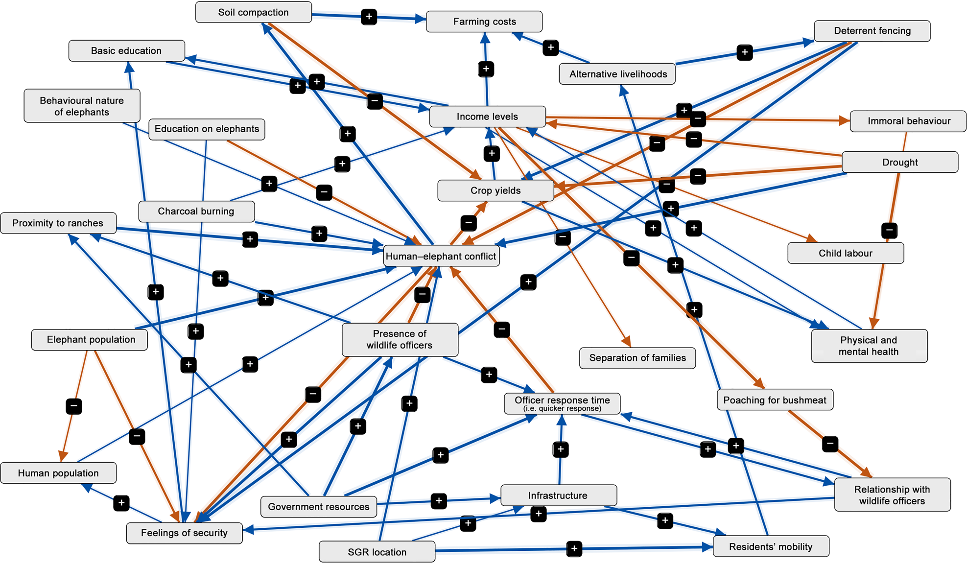
A fuzzy cognitive map of variables related to human–elephant conflict. The map was created with Mental Modeler software from a participatory session in the village of Bungule in the Kasigau Wildlife Corridor, Kenya. Variables are linked together through connecting lines (edges) with the strength of association represented by the thickness of the lines. To read the model, take any variable with an arrow originating from it and with an increase of said variable it will have either a positive and increasing (a plus (+) sign) or negative and decreasing (minus (–) sign) causal influence on the variable it is connected to. SGR, Standard Gauge Railway.
During input of the village models, we noticed complexity seemed to increase with successive sessions. Thus, we evaluated if changes were occurring linearly by plotting the density metric over time and the number of variables, connections, drivers and ordinary components, and tested these with a linear regression. The positive correlation coefficient values for variables (P = 0.002), connections (P < 0.001), drivers (P = 0.006), and ordinary components (P = 0.007) ranged from 0.93 to 0.98, and the density had a negative correlation coefficient of −0.98 (P < 0.001). We therefore concluded that the likely reason for this significant increase in variables and complexity was that the facilitator improved their skills over time, resulting in the models becoming more complex.
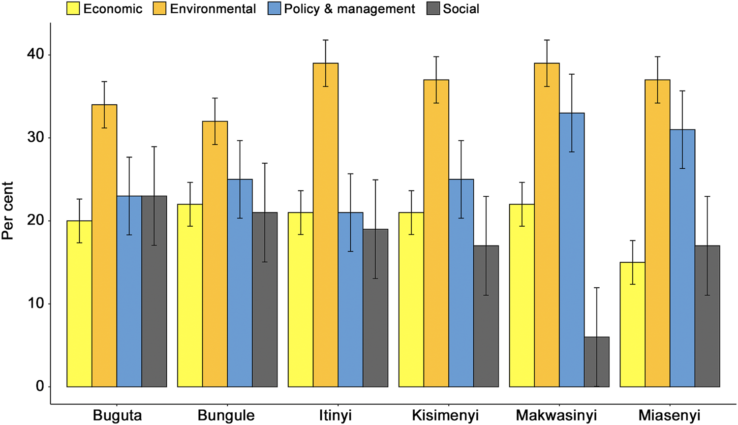
To address and compensate statistically for this facilitator adaptation and potential bias, we created a qualitative aggregation method across villages (Fig. 3; Vasslides & Jensen, Reference Vasslides and Jensen2016; Misthos et al., Reference Misthos, Messaris, Damigos and Menegaki2017) by establishing four locally relevant categories to group each variable from the respective village models: economic, environmental interactions, social, and policy and management. To better visualize the categories into which each variable fell, we assigned a different colour to each category, resulting in a cognitive colour spectrum (Cholewicki et al., Reference Cholewicki, Breen, Popovich, Peter Reeves, Sahrmann and van Dillen2019; Supplementary Fig. 6). We calculated the percentage of variables within each category for each village and compared the means of each category with ANOVA, and used a Tukey's post hoc honest significant difference test for multiple comparison.
A qualitative aggregation of model variables in four categories from participatory sessions with six villages in the Kasigau Wildlife Corridor surrounding the issue of human–elephant conflict. Error bars show the standard deviation.
The lead author (LVH) developed a single co-created model of human–elephant conflict (Fig. 4) based on input from the six village models, literature references on wildlife conflict, knowledge of the local system from a conservation practitioner's perspective and input from farmers during the sessions (Supplementary Table 2). We conducted all statistical analyses in R 4.0.2 (R Core Team, 2020) with an alpha value of 0.05.
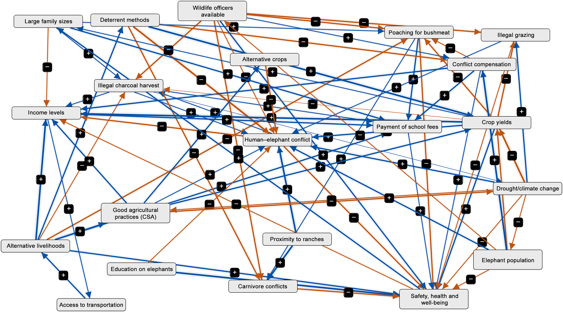
A fuzzy cognitve map of variables related to human–elephant conflict based on the authors’ knowledge of the local context, expertise of local villagers, and literature. Variables are linked together through connecting lines (edges) with the strength of association represented by the thickness of the lines. To read the model, take any variable with an arrow originating from it and with an increase of said variable it will have either a positive and increasing (a plus (+) sign) or negative and decreasing (a minus (–) sign) causal influence on the variable it is connected to. CSA, climate smart agriculture.
Results
To achieve our goal of developing a systems view of human–elephant conflict, we first evaluated stakeholder participatory models. To demonstrate how the fuzzy cognitive maps are visually interpreted, we use the variable elephant population as an example in Fig. 2: the arrow originating from this variable to human–elephant conflict has a positive sign, meaning that a higher elephant population had an increasing effect or influence on human–elephant conflict. The thicker line means it has more influence than other variables with thin connections. An example of a negative influence is the relationship of education on elephants and human–elephant conflict, meaning that more education about elephants decreases the impact of human–elephant conflict. Of the six study villages, Bungule had the highest complexity score (a potential indicator of complex systems thinking) and Miasenyi had the highest number of overall variables, connections, driver variables and ordinary variables, and the lowest density (Table 1). In the qualitative aggregation for the four categories of variables (economic, environmental interactions, social, and policy and management), environmental interactions emerged as the leading source of grouped variables, followed by policy and management (Fig. 3, Supplementary Fig. 6). These four variable categories differed significantly (F 3,20 = 23.86, P < 0.001), and post hoc analysis revealed significant differences between environmental–economic (P < 0.001, 95% CI = 9.31, 23.03), environmental–policy and management (P < 0.001, 95% CI = −16.86, −3.14), environmental–social (P < 0.001, 95% CI = −26.03, −12.31), and social–policy and management (P < 0.01, 95% CI = −16.03, −2.31).
Summary metrics of mental model components related to human–elephant conflict taken from participatory model sessions from six villages in the Kasigau Wildlife Corridor, Kenya, as part of fuzzy cognitive map construction.
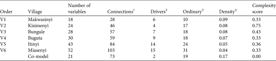
1 How many times variables were linked (degree of interaction with other variables).
2 Variables that affect interactions or variables but are not affected by other variables.
3 The number of concepts that influence and are influenced by other variables.
4 The number of connections compared to all possible connections.
Participating farmers shared similar perceptions of conflict, as 14 variables were consistent across all models including the key variable human–elephant conflict. Income level held the highest centrality score, followed by feelings of security (Table 2). The co-created, local model shared many of the same variables as the individual village models (Fig. 4). However, variables not prevalent in the village models were present in the co-created model that were known concerns from local conservation agencies and NGOs, and this model also had more reciprocal relationships.
Fuzzy cognitive map centrality scores (a measure of importance to overall dynamics, calculated by the number of connections to each variable) from six villages in the Kasigau Wildlife Corridor, Kenya, and the top 14 variables related to human–elephant conflicts that were common across all villages.

To address our second objective of determining if novel system components were present, we identified variables representative of novel or underrepresented drivers and consequences of elephant conflicts. Fire setting occurs when farmers light fires to remove dead vegetation, often post-drought, on their land. However, these fires are not closely managed and can confuse or alarm elephants, causing some elephants to retreat away from farms but others to go further into farmlands. The variable rearing culture of elephants originates from some farmers' beliefs that conservation agencies that rehabilitate and release elephants into Tsavo are making them less wild, causing them to enter farming areas with little fear of humans. Protection from God is indicative of a strong religious and sociocultural belief in that the more one gives to God (in the form of devotion, time or money), the more protection is received from crop foraging elephants. Infrastructure referred to some rural roads that can become unnavigable, especially during the rainy season, resulting in wildlife officials being unable to reach farmers complaining of elephant presence.
The variable soil compaction is one of several consequences that create economic challenges for farmers. Farmers stated that when elephants frequent the same areas of land, they compact the soil, resulting in the added cost of renting equipment to plough their fields. The immoral behaviours variable reflected farmers' beliefs that when income levels were low, drug and alcohol abuse, pre-marital relations, theft and crime all increased because people became idle or depressed. The parallels between these social behaviours and the negative impacts of human–elephant conflict have yet to be highlighted. However, other issues besides crop foraging can contribute to some of these behaviours, further illustrating the system's complexity. Finally, child labour results when a family has limited funds because of crop damage/loss and must take their children out of school to earn income or stay home and support the family with farming tasks.
For the third objective, using a biocultural approach to assess if indicators for measuring the success of mitigation programmes were present, we identified variables related to elephant conflicts that could be adapted as indicators. Early marriages and pregnancies and motherhood deliveries may result when incomes decrease and girls or young women (typically aged 15–22 years) marry earlier than expected as they feel a need to be provided for and secure. Thus, when harvest and incomes are good, marriage and pregnancy are delayed until desired. However, these variables can also be affected by other hardships. Separation of families was also noted as a negative consequence: when crop yields are low, male household members may have to leave home to find work elsewhere.
The Standard Gauge Railway emerged in some models as a novel local variable. Construction of the railway, which began in 2014, has been controversial because it reduced pathways available for wildlife to cross one of the main highways bisecting Tsavo East National Park (Okita-Ouma et al., Reference Okita-Ouma, Lala, Koskei, Mwazo, Kibara and King2016). Some villagers believe proximity to railroad underpasses increases or redirects elephants' access to farms. All variables by village and category are included in Supplementary Fig. 6.
Discussion
By evaluating the participatory models constructed during our sessions with local farmers, we clearly distinguished how farmers conceptualized human–elephant interactions across the villages. Many complex interactions between variables were displayed in the models, showing that local expertise is invaluable for gaining insights into conservation issues (Vogel et al., Reference Vogel, Songhurst, McCulloch and Stronza2022). Several variables stood out as underrepresented drivers and consequences of human–elephant conflicts, such as soil compaction by frequent elephant visits, and the lack of reliable road infrastructure, leading to wildlife officers being unable to reach some farms. Some variables were novel to this ecosystem, such as the local railroad altering wildlife movements; our new insights on this issue can be used to address concerns of local villagers and develop specific management plans. Using a biocultural approach, we found that certain variables could potentially be adapted as indicators to gauge mitigation programme success with respect to socio-cultural aspects, such as feeling more secure, reduced early marriages, or families remaining intact instead of men leaving home to find work. By using more cultural approaches in lieu of the standard socio-economic indicators to assess programme success (Dacks et al., Reference DeRoy, Darimont and Service2019), we can ensure that human culture, health and well-being are considered when addressing conservation issues. Our success in gaining intimate knowledge of this system indicates the potential for this methodology to be used with other stakeholders across a broad range of conservation issues.
With income levels being the dominant variable across the villages (aside from human–elephant conflict), it is clear that the economic impacts from crop foraging are a key driver of conflict in this community. In particular, when income levels are reduced, individuals have fewer resources available to address challenges such as drought or medical emergencies (Twomlow et al., Reference Twomlow, Mugabe, Mwale, Delve, Nanja, Carberry and Howden2008; Mcleod et al., Reference Mcleod, Szuster, Hinkel, Tompkins, Marshall and Downing2015). Feelings of security emerged as an important variable, which corroborates results from other surveys showing the majority of villagers live in fear of elephants (Von Hagen, Reference Von Hagen, Schulte, Steury, Dunning, Githiru, Zohdy and Lepczyk2024) and earlier research that showed impacts of crop foraging are not only economic (McShane et al., Reference McShane, Hirsch, Trung, Songorwa, Kinzig and Monteferri2011; Barua et al., Reference Barua, Bhagwat and Jadhav2013; Mmbaga et al., Reference Mmbaga, Munishi and Treydte2017). These findings collectively point to human–elephant conflict as a multidimensional issue jeopardizing the ability of farmers to thrive across social, cultural and economic levels.
Environmental interactions were the dominant category in the models across all villages, demonstrating the connectedness of this socio-ecological system. The policy and management category was the second most prevalent type of variable, and participants voiced their concerns about the way these conflicts are managed. For the co-created local model, several issues prominent in this system were not highlighted by farmers such as the payment of school fees and illegal grazing (farmers are not allowed to graze their cattle in the Sanctuary). School fee payment and other intermittent events such as illness in the household can also drive an increase in other harmful activities such as charcoal production and bushmeat poaching (Zulu & Richardson, Reference Zulu and Richardson2013; Nyaki et al., Reference Nyaki, Gray, Lepczyk, Skibins and Rentsch2014). Thus, village models and those incorporating practitioner experiences had key differences. These types of differences can be an indicator of different priorities between ecosystem actors and various wildlife authorities and point to the need for further open dialogue about what is truly important to local communities.
Underrepresented and novel local drivers again demonstrated the utility of our methodology in exposing local concerns related to specific conservation issues and priorities for communication by wildlife officials. For example, soil compaction was an unexpected consequence of crop foraging by elephants, which demonstrated the importance of incorporating the knowledge of local people. One study evaluating the impacts of African elephant presence on soil found positive effects of moderate elephant presence but that soil moisture, infiltration rates, nitrogen mineralization and nitrification all decreased with increased elephant presence (Maponga et al., Reference Maponga, Ndagurwa, Muvengwi, Sebele and Nzuma2022). These negative effects of soil compaction from heavy elephant presence appear to be an issue already known to some local farmers. The variable farming spirit (how determined a farmer was to continue with their profession, despite losses incurred by elephants) could be adapted as a biocultural indicator as it relates to a sense of place and cultural identity, and it is sensitive to environmental impacts (DeRoy et al., Reference DeRoy, Darimont and Service2019).
Despite the novel and informative insights gained, there were limitations to this study. Firstly, there was the facilitator adaptation as the sessions progressed, as noted above. To avoid such issues and reduce bias for future project managers, we recommend training and practice sessions for facilitators prior to commencing the actual study. Secondly, although all participants were encouraged to share their opinions, differences in personalities or social intimidation may have caused some farmers to refrain from fully expressing themselves.
This study revealed several management implications for agencies working with farmers to mitigate the impacts of human–elephant conflicts, which can be applied to other wildlife conflicts. The first is the establishment of multi-dimensional indicators that capture both the ecological and social-cultural impacts of human–elephant interactions (Sterling et al., Reference Sterling, Filardi, Toomey, Sigouin, Begley and Gazit2017) to measure programme efficacy in local communities. Secondly, our findings suggest implementation of programmes that provide information for farmers and assistance with mitigation efforts. They also point to the need for additional research to assess the impact of social variables on human–wildlife interactions. Thus, implementing community-based programmes to increase community resilience can benefit both farmers and wildlife conservation. Our study demonstrated that working with stakeholders to gain insights into complex conservation issues such as human–elephant conflict is important for creating customized mitigation programmes that prioritize the livelihoods and health of people while simultaneously preserving ecosystem health.
Author contributions
Study design: LVH, SAG, BAS, MG, CAL; fieldwork: LVH, HIK; data analysis: LVH, HIK, SAG, CAL; writing: LVH, SAG, BAS, MG, CAL.
Acknowledgements
We thank our Kenyan collaborators at Wildlife Works including the community outreach team, staff scientists, rangers and office personnel for their support; Alex Wells for his help with GIS; and the Kenyan people including tribal administration, and survey participants who welcomed us into their communities. LVH was supported by grants from the International Elephant Foundation, the Elephant Manager's Association and Auburn University, and the project was facilitated in conjunction with the Earthwatch Institute and the Elephants and Sustainable Agriculture in Kenya project.
Conflicts of interest
None.
Ethical standards
This research abided by the Oryx guidelines on ethical standards. The survey and study design were reviewed and approved by Auburn University's Institutional Review Board panel (protocol no. 20-440 EX 2009), and Strathmore University's Institutional Ethics Review Committee (approval no. SU-IERC0877/20) in Kenya. This project operated under the PIC/MAT agreement between Kenya Wildlife Service and Wildlife Works, and with approval from NACOSTI, Kenya's science agency (license no. NACOSTI/P/20/2292).
Data availability
Data related to this project, except for identifying information related to participants, are available from the corresponding author upon request.


 Open access