


Introduction
Viking Age (AD 800–1050) burials containing ocean-going ships have fascinated scholars and wider audiences for many years—none more so than the remarkably preserved Gokstad and Oseberg Viking ship burials from southern Norway. Their rich grave assemblages included an abundance of organic remains, including sleds, textiles, tents, cooking equipment and a large number of animals accompanying the deceased in burial. The ships, the objects and the deceased have all been a focus of research since their discoveries in 1880 and 1904 (e.g. Nicolaysen Reference Nicolaysen1882; Brøgger et al. Reference Brøgger, Shetelig and Falk1917; Christensen et al. Reference Christensen, Myhre and Ingstad1992; Bonde & Christensen Reference Bonde and Christensen1993; Gansum Reference Gansum, Jennbert, Andrén and Raudevere2002; Holck Reference Holck2009; Nordeide Reference Nordeide2011; Bill & Daly Reference Bill and Daly2012; Bill Reference Bill2016; Bonde & Stylegar Reference Bonde and Stylegar2016; Pedersen et al. Reference Pedersen, Andersen, Simonsen and Erambert2016). The mound that covered these deposits, however, has received very little attention. In terms of number, burial mounds form the greatest archaeological resource in Scandinavia, yet few Late Iron Age (AD 550–1050 in Norway, including the Viking period) examples have been studied as intrinsic parts of the burial process (see also Gansum Reference Gansum2004).
Traditionally, grave mounds have been regarded as a covering for the dead: a mass of earth that marked the burial and little more. Viewed from the exterior, mounds are an outward, communal statement of the grave and its contents. These statements have been interpreted as combinations of power, wealth, status, legacy and the legitimation of communities or the interred individual(s), and the both (Ringstad Reference Ringstad1987; Fuglestvedt Reference Fuglestvedt1997; Gansum Reference Gansum1997; Thäte Reference Thäte2007; 6–75; Hvass Reference Hvass, Díaz-Guardamino, García Sanjuán and Wheatley2015). Rather than focus exclusively on the final form, it might be useful to consider the intricate and complex construction process of the mounds themselves. Burials are steeped in cultural and individual responses to death, including emotive reactions (Tarlow Reference Tarlow2000). Research often directs such interpretations towards the placement of the body and any associated objects. New theoretical approaches, however, offer important insights into the interpretation of burial mounds, with current perspectives embracing sensorial, emotive and referential aspects of objects and monuments, as well as the deceased (e.g. Hamilakis Reference Hamilakis2013: 92–101, Reference Hamilakis2017; Crellin Reference Crellin2017). The challenge to deconstruct our notion of the nature-culture divide (e.g. Pétursdóttir Reference Pétursdóttir2017; Harris Reference Harris2018) encourages us to view mounds as components of burials that contain references to the present and past, and as the creation of a sense of place that would endure. These theoretical perspectives, together with the application of geoarchaeological methods, can provide contextual data essential for the study of a mound's composition, building methods and its landscape setting. When applied to mounds such as Gokstad—spectacular in both its preservation and content—this combined approach can provide a baseline for reassessing the thousands of other Late Iron Age gravemounds in Scandinavia and contemporaneous burial monuments farther afield.
It is easy to forget that large mounds are composed of actively selected and sourced soils and sediments from the wider landscape (Leary & Field Reference Leary, Field, Leary, Field and Campbell2013). The evolving form of the burial mound during construction would have affected interactions between the living community and the dead, with the sourced materials forming the medium for this interaction. Burial in the Viking Age was complex and varied, with aspects of funerary rites akin to performance, and it enabled the (re)creation and renegotiation of oral memory (Price Reference Price2010; Williams Reference Williams2016). Each burial had individual traits within a broad scheme of considerable variation (Jennbert Reference Jennbert, Andrén, Jennbert and Raudevere2006; Lund Reference Lund2013). Once raised, the burial mound would have become the medium for those memories—the focal point for later interaction that embodied the social identity of the deceased.
This article examines the construction process of the Gokstad mound, using new information gathered during a campaign of coring and micromorphological analysis. The project's aim is to set the Gokstad burial in its cultural and landscape context using new approaches to advance archaeological interpretations (Bill Reference Bill and Brather2013). Of the best known Viking Age ship burials in Norway (i.e. Oseberg, Grønhaug, Storhaug, Borre and Tune), Gokstad is the only surviving burial mound to be investigated using such modern methods. The results reveal the communal intentions, careful planning and construction of the mound, suggesting that mound construction represented a central aspect of mortuary practice.
The history of the Gokstad mound
Dendrochronological analysis of the ship, the grave chamber and the grave goods shows that the burial chamber on the Gokstad ship was constructed between AD 895 and 903; a later break-in took place between AD 939 and 1050 (Bill & Daly Reference Bill and Daly2012). In 1880, local landowners began to dig into the mound, discovering wooden chips, worked wood, moss and fragments of hazel branches. On hearing about this, the State Antiquarian Nicolay Nicolaysen persuaded them to cease digging into the mound. Later the same year, Nicolaysen directed a more regulated excavation of the mound, which revealed the Gokstad ship and associated grave goods. A central trench was dug from the south, quickly encountering the stem of the ship (Nicolaysen Reference Nicolaysen1882). The ship's extent was then followed on either side, with a margin of ~2m, resulting in a single trench about 9–10m wide through the centre of the mound. The mound's south side was removed to extract the ship, leaving the north end and the eastern and western flanks relatively intact. The trench was left open for many decades, and in 1902, a local History Society dug four smaller trenches (Sørensen Reference Sørensen1902). In the late 1920s, the state of the mound was assessed and the trenches were filled in.
Methods
Today, the Gokstad mound measures approximately 48 × 43m and survives up to 5m in height. Weathering, excavation and reconstruction have markedly altered its exterior form (Figure 1). An initial ground-penetrating radar (GPR) survey provided details of the upper ~2m of stratigraphy, and suggested where original mound material was preserved (Trinks et al. Reference Trinks, Biwall, Eder-Hinterleitner and Larsson2007). Coring was selected as a minimally intrusive investigative method, and to diminish long-term degradation of the mound, all cores were backfilled with a marine clay-slurry mix to recreate the anaerobic conditions present in parts of the surviving mound.
The Gokstad Mound as it stands today (photograph by R.J.S. Cannell).

A motorised coring rig with 50mm-diameter screw augers and a 75mm cylindrical sample corer was commissioned. The 75mm corer could retrieve intact core sections up to 0.75m long. This allowed the extraction of samples suitable for micromorphological analysis. Before coring with the 75mm corer, the 50mm auger was used to establish the mound's stratigraphy and its condition and identify points of interest, such as the location of the tenth-century robber trench and any preserved pre-mound ground surface (Figure 2). Each 50mm core was documented in the field, and surveyed core points and depths were digitised. This created a stratigraphic model of the preserved mound and the disturbances to the original structure, which enabled an adaptive coring strategy.
The locations of the cores and profiles discussed in the text; the shaded area is that with preserved topsoil (illustration by R.J.S. Cannell).

The cores were later sub-sectioned for further processing and analysis. A total of 38 thin sections were subjected to micromorphological analysis following established protocols for soil/sediment characterisation, microfacies types, pedofeatures and inclusions (see Macphail et al. Reference Macphail, Bill, Cannell, Linderholm and Rødsrud2013). The data from individual cores were simplified and processed using 3D software Rockworks 15© by Rockware. This enabled interpolation between coring points to create hypothetical reconstructions of the preserved and previously removed areas of the mound. The sections created by models were then used as templates for illustrations in Autodesk AutoCAD© and Adobe Illustrator®.
Results
The central area of the mound where the 1880 trench was located and later backfilled was too stony to be cored. Consequently, our results focus on data from the preserved flanks and areas immediately outside the mound itself (Figure 2). Coring depth was between 2 and 5.35m, as dictated by GPR and augering data. Further details of the palaeo-environmental interpretations based on micromorphology data are documented in Macphail et al. (Reference Macphail, Bill, Cannell, Linderholm and Rødsrud2013).
Coring creates issues with continuity when identifying relationships between archaeological contexts, as correlating and extrapolating what are essentially single point data from one core to another requires interpretative assumptions of both similarity and depositional factors. It is, however, indispensable in creating a cohesive model when excavation is not possible. Compared to excavation, the representative nature of coring data for interpreting phases and strata are limited—an inevitable consequence of minimally intrusive approaches. Within the mound, coring identified 54 contexts, a few of which appeared in most of cores. These contexts can be reduced to broad categories that typify the mound construction and later disturbance. From these categories, the mound was essentially constructed using cut wetland/grazed turf, redeposited subsoil material from distinct soil horizons and combinations of these groups that were mixed either by later bioturbation and weathering or intentionally during the construction of the mound itself. These layers were, to a significant degree, kept quite separate and placed in a particular order, with sharp interfaces suggesting a deliberate, pre-conceived sequence and a relatively rapid construction.
The pre-mound ground surface was gently undulating, with soils typical for the wider area, comprising: Luvic Stagnosols and Epistagnic Albeluvisols (Norwegian Institute for Bioeconomy Research 2018), as classified by the world reference database (United Nations Food and Agriculture Organization 2006). This equates to soils with poor drainage that are periodically surface-saturated. The soil layers identified in the vicinity of the mound contain the master horizons described in Figure 3. The water table in these soils is high, as identified through redoxic features in the soil profile. The topsoil is occasionally saturated and the wetting front lies in the upper B horizon (Bg1 in Figure 3).
Core SP1 detailing the local soil conditions in the immediate vicinity of the Gokstad mound (illustration by R.J.S. Cannell).

Based on the coring data, the sequence of the mound's construction can be reconstructed as follows.
Digging down
First, an area near equal in size to the mound base was stripped of topsoil, with the exception of a small, slightly raised area to the north-east that was left intact. Second, in the stripped area, the upper subsoil (Bg1 in Figure 3) was removed to create a slope towards the centre of the mound. Third, in the central area, the lower subsoil (Bg2) was removed. Nicolaysen (Reference Nicolaysen1882: 5) identified horizontal logs placed perpendicular to the ship as supports, implying that the central trench had steeper sides in order to be able to abut these logs. The lower subsoil is below the modern water table. Towards the centre, the mound has depths of up to 1.60m below the Viking Age topsoil surface (core SP45, see the online supplementary material (OSM)).
Perhaps sometime during this stage of mound construction, turves were cut from the surrounding landscape and stacked, ready for use on the upper mound. Micromorphological analysis reveals some loss of organic matter and regrowth in the turves, suggesting that they were stacked for a short period before use, either on or off the mound. This gathering of material may have occurred here or slightly later in the construction process.
Trenching in
In the centre of the excavated area, a shallow trench was dug for the ship's keel. Next, the ship was placed in the trench (Figures 4–7), using logs to support it. As mentioned previously, a small raised area to the north-east of the ship was left intact. To either side of this rise, some of the upper subsoil was stripped away, but the lower subsoil remained intact. This created a low, dry ridge to the north of the ship. Micromorphological analysis of the preserved topsoil layer confirms this was a trampled area that we tentatively interpret as having been covered, rather than directly trodden down. This area was maintained and used in connection with preparing the ship for the burial, and was a probable location for a gangplank to access the ship once in position (Macphail et al. Reference Macphail, Bill, Cannell, Linderholm and Rødsrud2013).
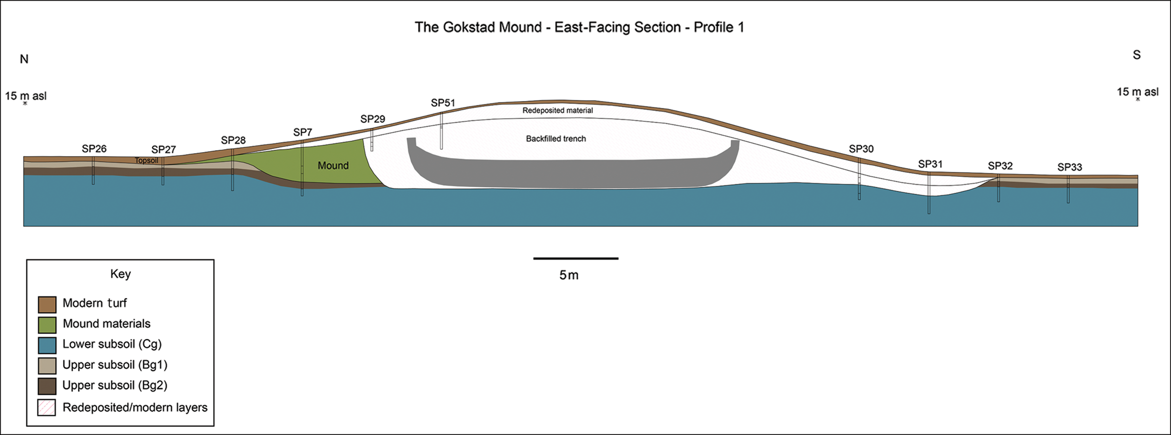
Profile one through the mound; the position of the ship is illustrative and approximate (illustration by the authors & L. Gustavsen).

Profile two through the mound, showing the position of the robber trench and mound layers (illustration by the authors & L. Gustavsen).

Profile three through the mound, showing the selective removal of layers on the northern flank, and the preserved area of topsoil (illustration by the authors & L. Gustavsen).

Profile four through the mound, showing a highly simplified stratigraphy. The position of the ship is illustrative and approximate (illustration by the authors & L. Gustavsen).

Bringing in the dead
The placement of the grave goods in the burial, including the grave chamber itself, is not considered here. It is assumed for the purposes of this article, however, that most of these were placed at this stage of the burial, after the ship was positioned in the trench. While the ship was accessible from the ridge to the north-east, it was probably also accessed from the south due the presence of a gangplank (Nicolaysen Reference Nicolaysen1882: 52). It is also possible that the grave goods and animals within and surrounding the ship were placed slightly later in the sequence of events. The 1880 excavation data suggest that after the grave was prepared, a gangplank was placed over one of the dogs to the port side of the ship, towards the south/fore. The organic materials were well preserved in the blue clay silt. From the preservation of the gangplank and the animals placed on the same level, it is therefore assumed that these were also covered to some degree by blue silty clay (see Figure 7), although Nicolaysen (Reference Nicolaysen1882) does not address the burial mound's stratigraphy explicitly. This demonstrates that this layer was of a similar height with the objects surrounding the ship, which were described by Nicolaysen (Reference Nicolaysen1882: 52) as being just below the gunwale.
Reconstructing the land?
The first layers placed to rebuild or reinstate the area opened up for the burial were of blue silty clay (Figure 7), which was packed around the ship, filling in the muddy pool that must have formed around the vessel. This silty clay seems to have been packed up to the third strake and the line of shields, and blue clay slurry was observed on the deck and over the grave goods during excavation (Nicolaysen Reference Nicolaysen1882). In his publication of the Tune ship, Shetelig (Reference Shetelig1917) states that blue clay was placed around the Gokstad burial chamber, although Nicolaysen only mentions layers of birch bark. It can be assumed that the blue silty clay was in contact with the base of the grave chamber, as it covered the ship's deck. What is remarkable about this layer of redeposited silty clay is the lack of oxidisation lenses that would be expected to form during storage between excavation and construction, and the lack of inclusions from contact with other materials. Indeed, to the naked eye it is very ‘clean’, to the point at which it was sometimes challenging to identify the boundary between the redeposited material and the in situ ‘natural’ layers of blue silty clay (Cg) in the cores.
Re-turfing
Core SP45 provides evidence that a single layer of turf had been placed grass-side up on the blue silty clay and then covered in wood chips, possibly from woodworking or another as yet unknown activity (see the OSM). A similar observation was made by Sørensen (Reference Sørensen1902) for one of the trenches dug in 1902, and Nicolaysen (Reference Nicolaysen1882) also recorded twigs and hazel faggots covering the silty clay in the vicinity of the ship.
Micromorphological analysis reveals that neither the first turf layer over the silty clay nor the upper surface of the blue silty clay itself shows evidence of extensive trampling. This observation further supports the idea that the small area of preserved soil to the north-east of the ship, where trampling was more extensive, was used as an entry point into the ship during the preparation stages.
The reserved turf was then stacked onto the exposed dome of blue silty clay (see the OSM). On the mound, the stack of turf thickens towards the centre and is assumed to have covered the burial to create the mound's shape. This thick layering of turves shows some inconsistencies in its construction. In a proportion of the cores, a layer of highly humified material and redeposited subsoil material is present (Figure 6). Its similarity with the B horizon materials removed prior to placement of the ship gives us a source. There is a discernible pattern in its sequence in the mound construction: it appears over the blue silty clay and under the better preserved turves, but also as layers between these turves. Perhaps it provided additional stability to the mound, as well as a means of using all available excavated material.
According to Sørensen (Reference Sørensen1902), there were 14 layers of turf, over which lay 2m of clay (Sørensen Reference Sørensen1902). Coring suggests that the upper layers of the mound were more mixed. That said, this upper mound material is also the upper metre directly beneath the modern reconstructed material and so may have been more disturbed. Moreover, this represents the well-drained zone of active soil formation that has been bioturbated for the 1000 years since the mound's construction, and it is possible Sørensen mistook this for an entirely new layer.
It is notable that all of the materials thus far identified in the mound construction could have been sourced from the surrounding landscape. The marine silty clay that comprises the local lower subsoil/parent material (Cg) in the area is widespread in Vestfold and readily forms wetland soils that are suitable for grazing, such as those used in the mound construction.
Time
The duration and season of the construction process are indirectly evidenced from the coring and micromorphological data. The turves were stacked for a period and began to regrow, suggesting perhaps a period of weeks before they were used, and that the season was warm enough for this regrowth to occur. There is, however, a lack of weathering rinds or oxidation surfaces on the blue silty clay used in the burial, indicating that it was not exposed and drained for a considerable period before use.
Discussion
The mound materials
It has been suggested that at Gokstad, the placement of certain materials—particularly blue silty clay and turf—was intended to preserve the ship and grave goods (Nicolaysen Reference Nicolaysen1882: 69–70; Brøgger et al. Reference Brøgger, Shetelig and Falk1917: 139). The range of materials used, such as moss, hazel faggots, birch bark and turf, had practical implications and functions, while also implying that certain materials were seen as more appropriate than others for particular tasks. This cannot be explained entirely by the intention to preserve the ship for perpetuity, or by the finite resources of the local landscape. The range and quality of the grave goods (see Nicolaysen Reference Nicolaysen1882: 37–54) suggests the impetus and opportunity to gather resources on an unprecedented scale. Thus, it is illogical to assume that after the burial chamber was covered with birch bark or moss placed over the deck, there were insufficient supplies of these materials for use elsewhere. The placement of earth-sourced materials in a particular order in the mound—and within the ship itself—created and changed associations and references to the wider landscape, and between the community and the deceased (Crellin Reference Crellin2017). What is more, these materials were separated and ordered, implying cultural notions of permissible associations, and the use of these to sculpt memory. Vivid contrasts in colour and texture would have been apparent at each stage, from the blue of the silty clay to the green mosses, silvery birch bark and black turf, all of which contributed to the impact on the observer. The process and result broadcast mnemonic tendrils over the landscape: sheep grazing in wet pastures, coppiced woodland, the hidden layers beneath people's feet, to flowing and standing water, and all the interwoven references each of these materials had for the community prior to the construction of the mound. While the scale of the Gokstad burial amplifies this web of emotive references, further research is required into whether or not more modest burial mounds contain such references in their construction.
Mortuary practice is deeply connected to creating and maintaining ideologies and identities (Williams Reference Williams, Carver, Sanmark and Semple2010). The deliberate manifestation of social identity at Gokstad reaches beyond the artefacts and into every component of the burial. Interaction with the soil in the past may have had connotations of time, place, belonging and, not least, renewal and regrowth (Given Reference Given2018). The land and its soils created a sense of place, and their use in burial embedded those references into mortuary practices and identities.
Prior to the construction of the Gokstad mound, the immediate landscape was settled and farmed. The Heimdalsjordet trading site was only 500m to the south. Although today the mound appears isolated in the landscape, it is located close to another burial mound, which remains undated. It also has a clear line of sight to another 20 or so burial mounds, identified by excavation and GPR (Bill & Rødsrud Reference Bill, Rødsrud, Glørstad and Loftsgarden2017). The construction of such a large, prominently placed burial mound as Gokstad, sited centrally within the valley, would have been a transformative moment in the physical and cognitive landscape. This transformation deliberately altered the axis of the landscape by creating a dominant point in the valley. It must be noted that the mound was placed in a settled Viking Age landscape comprising permanent field systems and extensive, managed grazing (Grabowski Reference Grabowski2011; Macphail et al. Reference Macphail, Bill, Cannell, Linderholm and Rødsrud2013). The surrounding landscape was formalised by field boundaries and fences, with established paths of movement that directed human responses and limited alternative actions (Løvschal Reference Løvschal2014; Løvschal & Holst Reference Løvschal and Holst2014). The mound was therefore placed where it would be frequently encountered and experienced at close quarters and where it would endure as a guide in the landscape and in oral memory (Back Danielsson Reference Back Danielsson, Williams, Kirton and Gondek2015; Williams et al. Reference Williams, Kirton, Gondek, Williams, Kirton and Gondek2015). The mound evoked and transformed selected memories, with its multiple references—within and without—to the labour and local resources used in its construction, to death and enduring legacy, and, indeed, to similar mounds such as Oseberg.
The mound building also left scars in the landscape, such as the de-turfed areas that would occasionally have become pools of standing water. These would have needed decades to heal before they were once more suitable for cultivation. These turves came from a local, settled landscape, in which either individual or communal land ownership was already established. The turves were therefore given as a resource by the individual or group towards the creation of the mound (Gjerpe Reference Gjerpe, Iversen and Petersson2016).
Building down, building bridges
To dig down into the landscape on such a scale at Gokstad is distinctive. A comparison with other, well-excavated, contemporaneous mound cemeteries such as at Gulli (also in Vestfold), shows excavated ring ditches and, in a few cases, a small trench for the body and/or boat (Gjerpe Reference Gjerpe2005: 25). Although extensive digging at Gokstad had practical advantages in reducing the volume of material needed to cover the ship, it would also mean engaging with heavy, waterlogged sediments. It is clear that prior to setting the ship in the grave, layers of subsoil had been selectively removed from a large area, and these were later used, together with materials gathered from the landscape, in the upper mound construction. This was a systematic approach to mound construction, setting the ship and grave into and under the earth. We can speculate whether this had associations with becoming part of the underworld, as part of the pre-Christian understanding of the world (Gansum Reference Gansum2004: 179).
The digging down and consequent removal of soil layers to create the burial monument is not unique to Gokstad, nor is the selective placement of clean sediments. The burial mound of Bjerringhøj in Mammen, Denmark, dating to c. AD 970, for example, was dug down approximately 1.40m before the large chamber grave was constructed. This included the placing of clean, marine-sourced blue silty clay around the chamber timbers—a sediment that was not locally available (Iversen et al. Reference Iversen, Näsman and Vellev1991). We could conclude that this was practical: the creation of an anaerobic environment with blue silty clay would increase the preservation potential during and after burial (Gansum Reference Gansum2004: 179). This motive has also been suggested for the use of iron pan in Bronze Age burial mounds (Breuning-Madsen et al. Reference Breuning-Madsen, Rønsbo and Holst2000, Reference Breuning-Madsen, Holst and Henriksen2012). Functionalistic assumptions can always be made from finite evidence: the excavation of ditches, for example, to provide materials for grave mound construction. But as many grave mounds, including Gokstad, do not have ring ditches, we cannot assume that this was their sole purpose (Price Reference Price2010). Assuming solely practical intentions may overlook the effect of these actions. Clean, deep-sourced material rarely seen in everyday interaction with the land could also have had emotive connotations, while simultaneously benefitting preservation. The non-local blue clay at Bjerringhøj, which was built on coarse, sandy sediments, perhaps had associations with a completely different place in the landscape.
We propose that burial rites drew together a diverse mix of people, combining social groups in a shared action through which ran mythical and religious threads (Holst & Rasmussen Reference Holst, Rasmussen, Holst and Rasmussen2015). Myhre (Reference Myhre2015) notes that the broad, causewayed, annular ditches around the larger mounds at Borre were commonly (and intentionally) filled with water, and speculates that this represented the bridge over the river that divides Hel (the realm of the dead) from the living. The causeways represent a passage between the living and the dead—a liminal space between the two states. Deposits in wetland contexts, particularly those associated with bridges, are recorded repeatedly in Viking Age contexts (Lund Reference Lund2008). Perhaps at Gokstad, the creation of a defined passage to the ship via the preserved, trampled topsoil had similar purposes: as a reference to the physical and mythical landscape, and the space between. Gangplanks were not costly items. They were functional facilitators and should be interpreted as such, rather than esteemed as grave goods. In Oseberg, the gangway was found inside the ship, on top of everything else loaded onto the foreship. At Storhaug and Grønhaug, however, they were found lying outside the ship, and were therefore not considered as necessary equipment for the voyage of the dead. Their function at Gokstad was to facilitate the liminal boundary to the dead—to a ship surrounded by a pool of watery blue clay.
Landscape location is a vital element in constructing memory, the sense of where being central to the repeated act (Gosden & Lock Reference Gosden and Lock1998). Myhre (Reference Myhre2015), for example, suggests that the creation of the Borre cemetery as an arena for events connected with the dead was purposeful and cumulative, and acted as a focal point for memory creation (Back Danielsson Reference Back Danielsson, Williams, Kirton and Gondek2015). To this, we can add the creation of wetland (through digging down) surrounding the graves, with passages over liminal spaces between the worlds of the living and the dead. The Gokstad mound was dug below the water table, creating a pool of muddy water around the ship. By surrounding the ship with water and creating a ‘bridge to the dead’, these references at Gokstad were tangible and experienced on a physical level.
In its construction, the Gokstad mound reflects and alludes to the worldview of its creators—of their social and cultural ideology. The mound was an essential component in bringing the landscape, with all its social connotations, to the burial. It was also a component in navigating between the dead and the living, in creating a performative scene to generate, transform and maintain social memory of a communal action, and in turn, the memory of the deceased. As a focal point of the landscape, the mound's identity endured and morphed through continued interaction on every scale, to the extent that memory had to be reformed by a later break-in.
By approaching the mound as an integral part of the burial, and applying geoarchaeological methods to understand its formation, Gokstad can now be considered as more than a ship: it was a grave rooted in the landscape within which it was buried. This work opens avenues for further research into burial mound construction in Scandinavia and beyond, as a central component in the handling of the dead.
Acknowledgements
This research was funded by a Norwegian Research Council grant for the project ‘Using the Past in the Past: Viking Age Scandinavia as a Renaissance?’, in collaboration with the Gokstad Revitalised Project, which is funded by Anders Jahre's Humanitarian Foundation and the Museum of Cultural History. The authors thank Lars Gustavsen for his work on the AutoCAD illustrations.
Supplementary material
To view supplementary material for this article, please visit https://doi.org/10.15184/aqy.2020.162


 Open access