


A growing body of research is converging around the notion that the precontact society centered on Chaco Canyon (ca. AD 850–1140) differed in significant ways from nineteenth- and twentieth-century Pueblo societies known from ethnographic documentation (Fowles Reference Fowles2013; Lekson Reference Lekson2015, Reference Lekson2018; Mills Reference Mills2018; Plog and Heitman Reference Plog and Heitman2010; Stuart Reference Stuart2014). Most prominent among these differences is the presence of institutionalized ranking accompanied by wealth differences at Chaco, as can be seen in the multigenerational dynastic crypt of Room 33, cacao consumption in special drinking vessels, importation of tropical birds, and mortuary richness in Pueblo Bonito (Akins Reference Akins1986; Crown and Hurst Reference Crown and Jeffrey Hurst2009; Kennett et al. Reference Kennett, Plog, George, Culleton, Watson, Skoglund and Rohland2017; Plog and Heitman Reference Plog and Heitman2010). In contrast, leadership positions in the historic Pueblos are for the most part nonhereditary, and they do not bring material privileges for those who hold them (Dozier Reference Dozier1970; McGuire and Saitta Reference McGuire and Saitta1996). Monumentality at Chaco is also much more closely aligned with exclusive architecture—in the form of Great Houses—than is the case in the Protohistoric or more recent Pueblos, where architectural massing is associated with community buildings and the definition of public plaza space (Graves and Van Keuren Reference Graves and Van Keuren2011; Ruscavage-Barz and Bagwell Reference Ruscavage-Barz, Bagwell, Christine, Todd and David2006; Snead Reference Snead2008). Additionally, the Chaco World was hierarchically organized, with nearly 150 great houses, roads, and shared ceramic design styles covering a 100,000 km2 area, with Chaco Canyon standing as a clear regional center (Kantner and Kintigh Reference Kantner, Kintigh and Stephen2006). Although later Pueblos also shared aspects of architecture, ceramic technologies, and religious practice, there are no central, first-order settlements akin to Chaco. Finally, oral traditions of Pueblo and Diné (Navajo) people repeatedly emphasize that Chaco—characterized by hierarchy and the abuse of power—epitomizes the inverse of their present-day values (Begay Reference Begay and Noble2004; Ortiz Reference Ortiz, Peck, Lekson, Stein and Ortiz1994; Sofaer Reference Sofaer1999, Reference Sofaer2024; Swentzell Reference Swentzell and Noble2004).
Most discussions of the differences between Chacoan society and later Pueblo societies tend to directly compare archaeological evidence from Chaco with ethnographic and ethnohistoric information collected in the 1800s and 1900s (e.g., Van Dyke Reference Van Dyke2008; Ware Reference Ware2014; Whiteley Reference Whiteley, Carrie and Plog2015; Wills Reference Wills and Barbara2000). Although there is wide agreement that an ancestral connection exists between the Chaco World and later Pueblos, relatively few studies have compared Chaco-era (ca. AD 850–1140) archaeology with the intervening Pueblo archaeological record (but see Cameron and Duff Reference Cameron and Duff2008; Fowles Reference Fowles2013; Lekson Reference Lekson2009; Ortman Reference Ortman2012; Ortman and Traugott Reference Ortman and Traugott2018; Stuart Reference Stuart2014). We believe there are several reasons why such efforts have been rare. First, the social transformation is associated with a shift in the demographic center of Pueblo society from the San Juan to the Rio Grande drainage, and many archaeologists who specialize in Chacoan archaeology do not have much experience with more recent Pueblo archaeology. The lack of a systematic correspondence between the terminology used to describe archaeological features and time periods in the Chaco World and the Northern Rio Grande Valley has also likely hindered past comparative efforts. Second, because more recent Pueblo archaeology does exhibit continuity with ethnohistoric and ethnographic documentation, researchers investigating post-Chacoan Indigenous cultures tend to focus on connections with specific ethnolinguistic groups, including Hopi, Zuni, Tewa, and Keresan people (Bernardini et al. Reference Bernardini, Koyiyumptewa, Schachner and Kuwanwisiwma2021; Duwe Reference Duwe2020; Gregory and Wilcox Reference Gregory and Wilcox2007; Ortman Reference Ortman2012). For post-Chacoan Pueblo archaeology, the most relevant ethnographic information for interpreting a given site is clear—Tewa ethnography for Tewa sites, Keresan ethnography for Keresan sites, and so forth. In contrast, over 20 Pueblos and tribes throughout the Southwest claim affiliation with Chaco Canyon and its larger world, which problematizes the straightforward use of information from, or collaboration with, one specific ethnolinguistic group. Yet the fact that many Pueblo and Diné groups trace their origins to the Chaco World suggests that it is necessary to transcend linguistic boundaries to make sense of the transformations involved. Finally, although the direct historical approach may be worthwhile for tracing present-day ideas and practices into the past, it is the transformations—rather than recognition of continuities and discontinuities—that are of interest here. A focus on the beginning and the end points of the Chaco-to-ethnographic-Pueblo sequence makes it difficult to see the steps through which the transformation played out, and these steps are important for understanding how societies actually accomplish social and political transformation.
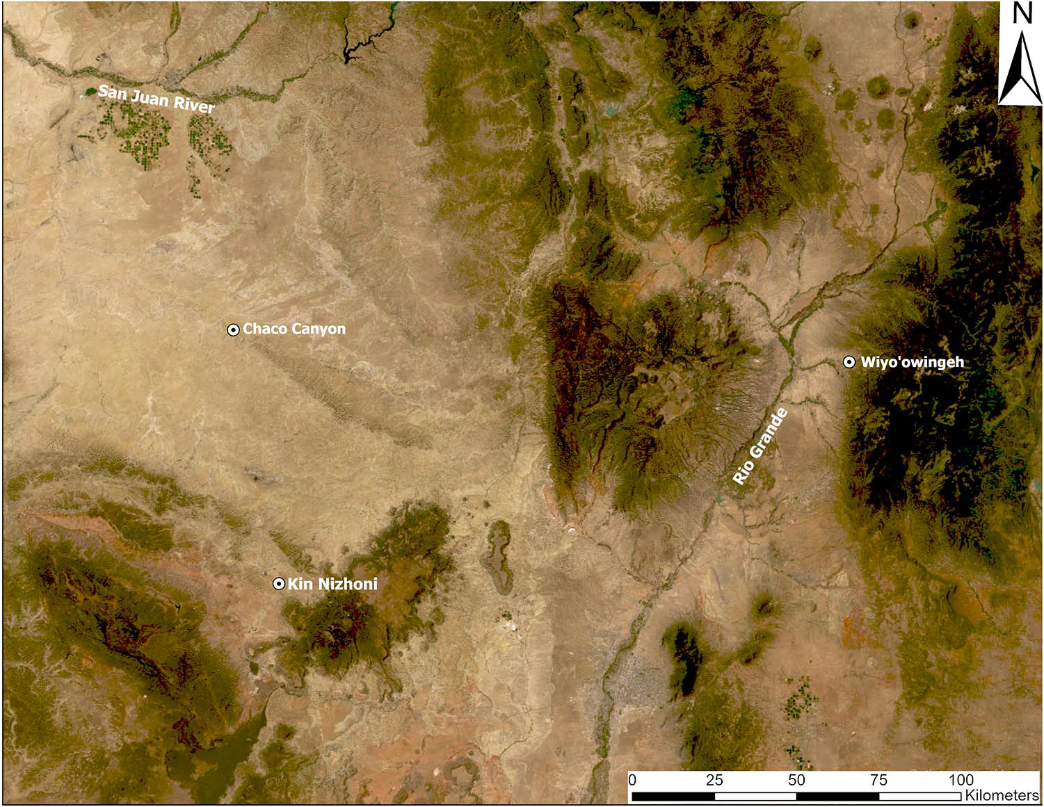
In this article, we compare the built environments of the Chaco-era community at Kin Nizhoni (LA 18166/18226) and the post-Chacoan Northern Rio Grande community at Wiyo’owingeh (LA 158) to trace continuities and transformations in Pueblo cosmology and society over time (Figure 1). Of the many Chaco-era and post-Chacoan communities that could be compared, we selected two sites where we recently conducted fieldwork and for which we have comparable lidar, ceramic, and small-architectural-feature survey data.
Regional map showing location of Chaco Canyon, Kin Nizhoni, and Wiyo’owingeh. Map by Robert S. Weiner. (Color online)

Our discussion fills a gap in previous discussions of the histories of cultural landscapes in the Southwest. Van Dyke (Reference Van Dyke2008) has interpreted Chacoan landscapes in terms of ethnographic Pueblo cosmology, noting continuities but focusing less on aspects of Chacoan cultural landscapes that have either been transformed or lost between the Chaco era and the present. Cameron and Duff (Reference Cameron and Duff2008) have compared post-Chacoan (ca. AD 1150–1300) transformations in the Northern San Juan and Cibola regions, showing that stronger adherence to Chacoan ways presaged regional depopulation and migration in the north (also see Van Dyke Reference Van Dyke2009), whereas weaker ties to Chaco were associated with aggregation into larger, plaza-oriented villages that persisted in the south. Their study, however, does not connect such differences to the emergence of contemporary Pueblo cultural landscapes. Finally, Snead and Preucel (Reference Snead, Robert W., Ashmore and Knapp1999), Fowles (Reference Fowles2009), and Duwe (Reference Duwe2020) have each discussed ways the shrine systems of ethnographically described Pueblo cultural landscapes took shape around late thirteenth– and early fourteenth–century Northern Rio Grande communities. These studies have successfully traced ethnographic material practices back to the period of migration and village formation in the Rio Grande, but they have not considered their deeper origins in the prior Chaco World.
What these studies have left unexamined is the ways in which Chacoan cultural landscapes were transformed into the post-Chacoan landscapes exhibiting continuities to the present. Here, we seek to fill this gap by comparing a tenth- to twelfth-century San Juan Basin community with a thirteenth- to fourteenth-century Northern Rio Grande community. Kin Nizhoni was constructed in the Red Mesa Valley, a core area of Chacoan settlement, and manifests widely observed features of Chacoan cultural landscapes. Wiyo’owingeh was constructed in the Tewa Basin, a core area of Rio Grande Pueblo settlement, by descendants of people who participated in the Chaco World (Ortman Reference Ortman2012). Our study infers patterns of transformation in elements of Chacoan cosmology that can be discerned through architecture, the construction of cultural landscapes, and traditional knowledge associated with the more recent settlement.
Our exploration leads to insights that work in both directions. On the one hand, we find that the built environments of both sites mark alignments with prominent landforms, express dualism, emphasize continuity with past eras, and mark belonging to larger imagined communities—but that architectural expressions of these concepts were materialized in more implicit and subtle ways at Wiyo’owingeh. This transformation, we suggest, illustrates continuity in the broad principles of Chacoan cosmovision in later Pueblo societies. On the other hand, we find that these ideas, which were mapped onto communal dwellings with spatially separated shrines in more recent Pueblo contexts, had been associated with special-use, elite architecture in Chacoan times. As a result, we suggest an inverse transformation: that the spiritual blessings associated with World Quarter Shrines and ancestral rain beings in later periods of Pueblo history were, during the Chaco era, understood as deriving from Great Houses and their residents. Ultimately, we conclude that archaeological studies of cultural landscapes and built environments offer a useful method for tracing relationships between religion and society over time.
The Kin Nizhoni Great House Community (ca. AD 950–1100)
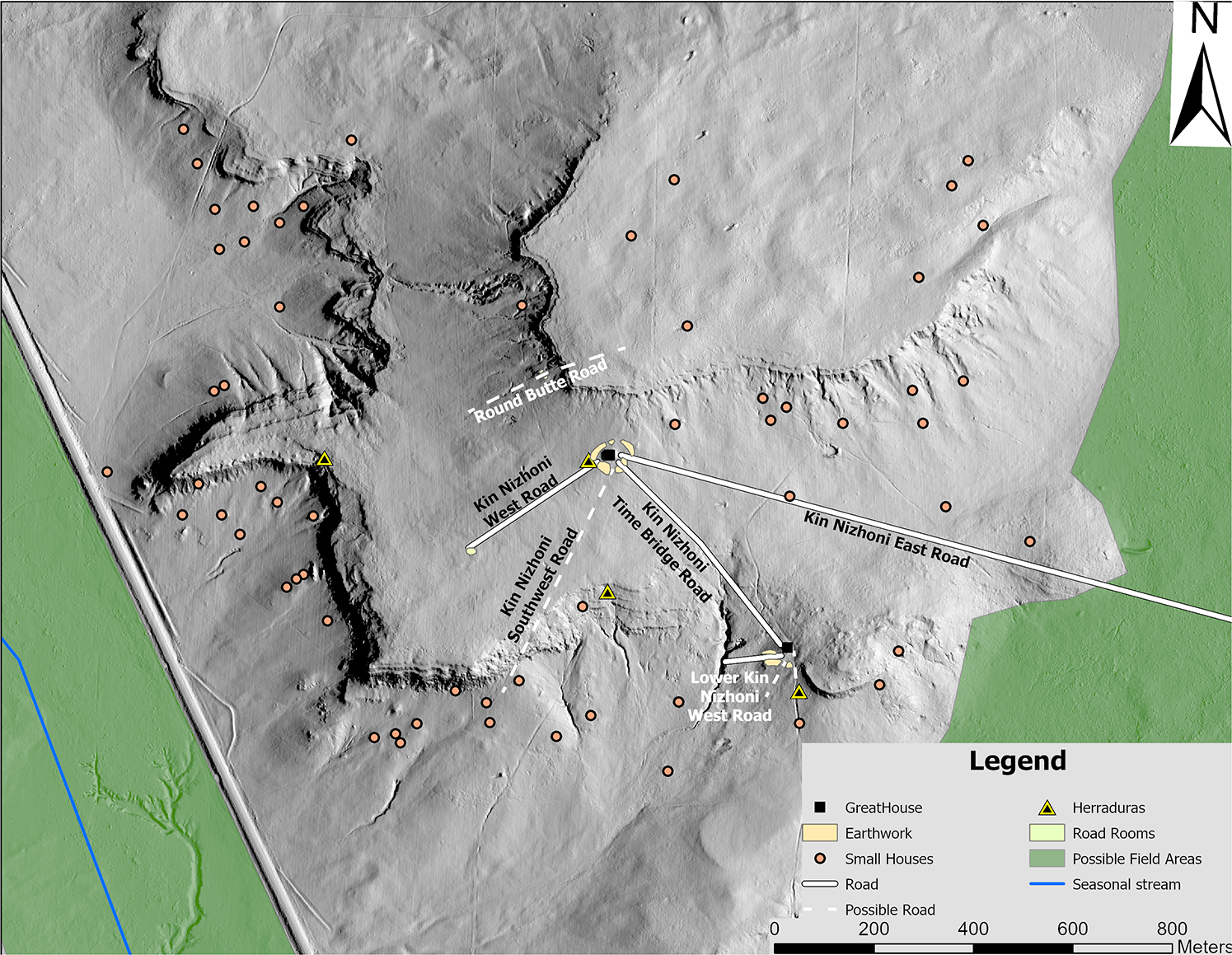
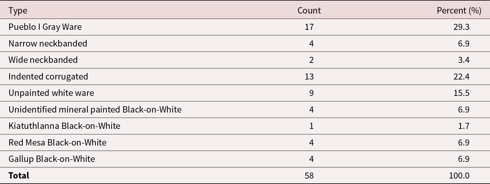
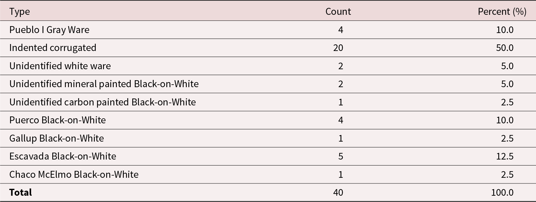
Kin Nizhoni is a Chaco-era Great House community located in the Red Mesa Valley approximately 75 km south of Chaco Canyon near present-day Ambrosia Lake, New Mexico, and the confluence of San Mateo Creek and Arroyo del Puerto. The site consists of two Chacoan Great Houses—Upper and Lower Kin Nizhoni (LA 18166 and LA 18226, respectively)—at least four (but possibly nine) road segments, and a community of at least 76 structures (LA 18167–18225; Figures 2 and 3a; Marshall et al. Reference Marshall, Stein, Loose and Novotny1979:169–185; Van Dyke Reference Van Dyke1998:164–166; Weiner Reference Weiner2023:336–380). Associated ceramics suggest that Lower Kin Nizhoni was used from approximately AD 850 to 1050 and that Upper Kin Nizhoni was used slightly later, from approximately AD 1020 to 1125 (Tables 1 and 2; Marshall et al. Reference Marshall, Stein, Loose and Novotny1979:169–185). All but one of the community sites date to AD 1000–1100 (Marshall et al. Reference Marshall, Stein, Loose and Novotny1979:169–185; Van Dyke Reference Van Dyke1998:165–166). Currently, there is no known evidence for constructed agricultural infrastructure at Kin Nizhoni, though archaeologists have not undertaken intensive surveys focused on identifying agricultural features there (in contrast, for example, to the Northern Rio Grande Valley). The ancient inhabitants of Kin Nizhoni would have practiced dry farming, likely focused on the area along Arroyo del Puerto to the west and the seasonally marshy floodplains near the community.
Kin Nizhoni community pattern. Map by Robert S. Weiner. (Color online)

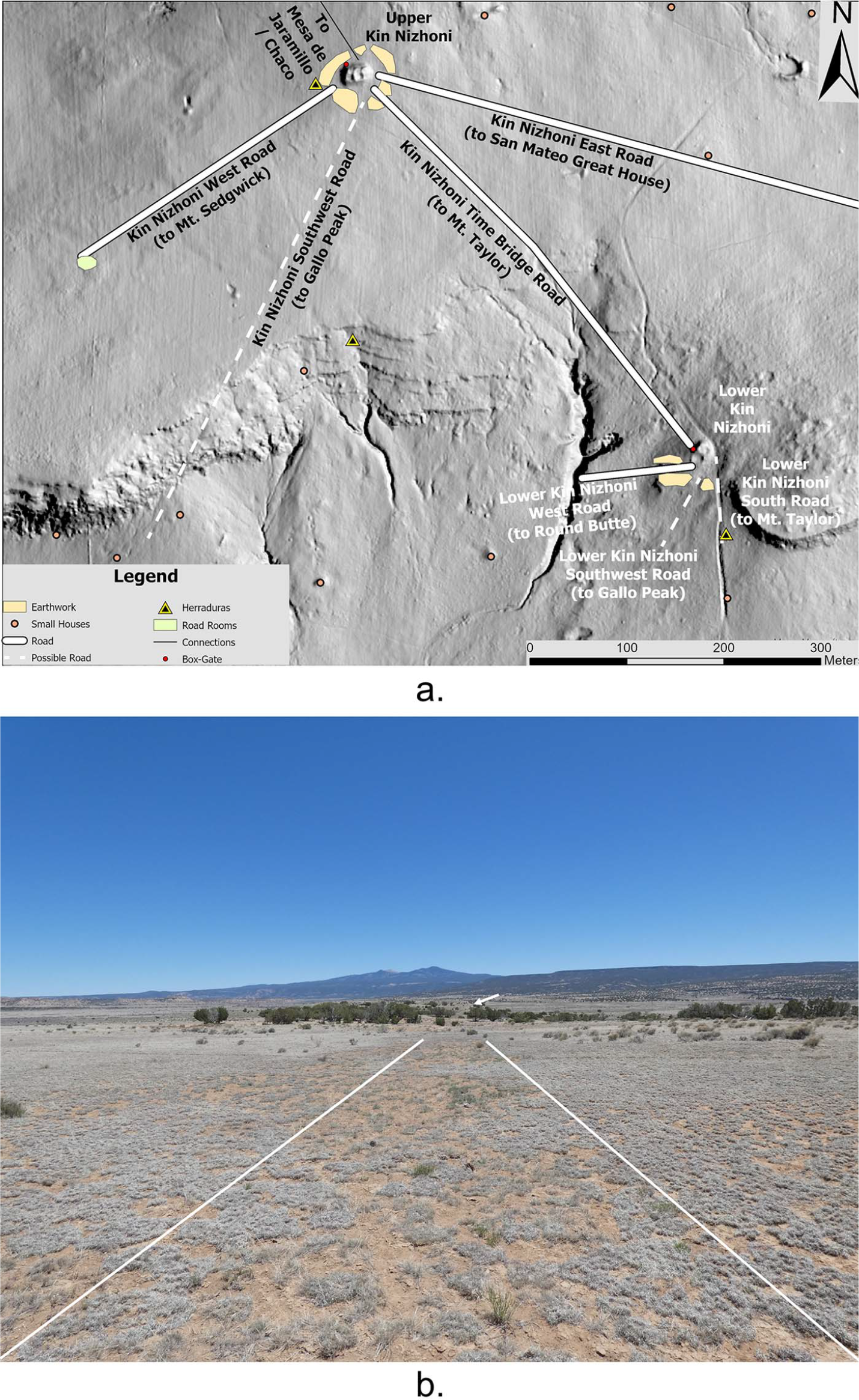
(a) Detail of Kin Nizhoni Great House landscape showing articulations between constructed roadways and the surrounding landscape, and (b) ground view looking southeast along the Kin Nizhoni Time Bridge Road toward Lower Kin Nizhoni (marked with an arrow), showing the alignment with Mount Taylor. Map and photograph by Robert S. Weiner. (Color online)

One Hundred Percent, 2 m Dogleash Ceramic Tally on Southwestern Earthwork at Lower Kin Nizhoni.

One Hundred Percent, 2 m Dogleash Ceramic Tally on Southwestern Earthwork at Upper Kin Nizhoni.

History of Research
Kin Nizhoni was originally documented as part of the Anasazi Communities Survey, which demonstrated the distribution of Chaco-style Great Houses throughout the San Juan Basin (Marshall et al. Reference Marshall, Stein, Loose and Novotny1979:169–185). Marshall and colleagues mapped the Upper and Lower Kin Nizhoni Great Houses and recorded 68 small-house sites, gathering ceramic tallies, structural dimensions, room count estimates, and midden dimensions. The Bureau of Land Management (1980) resurveyed the site in 1980 and recorded more small-house sites. The Bureau of Land Management Chaco Roads Project also revisited Kin Nizhoni to investigate four precontact roads tentatively identified through aerial photography (Nials et al. Reference Nials, Stein and Roney1987:127–128).
Weiner (Reference Weiner2023:336–380) documented Chacoan roads at Kin Nizhoni from 2019 to 2023, visiting the site eight times for intensive on-the-ground documentation. The project involved examination of light detection and ranging (lidar) imagery and aerial photography, acquisition of drone aerial photos to construct Structure-from-Motion photogrammetric digital surface models of the site, in-field mapping of roads, ceramic tallies at road-related structures, and discussions with community members from Acoma Pueblo, Santa Clara Pueblo, and the Navajo Nation.
Community Pattern
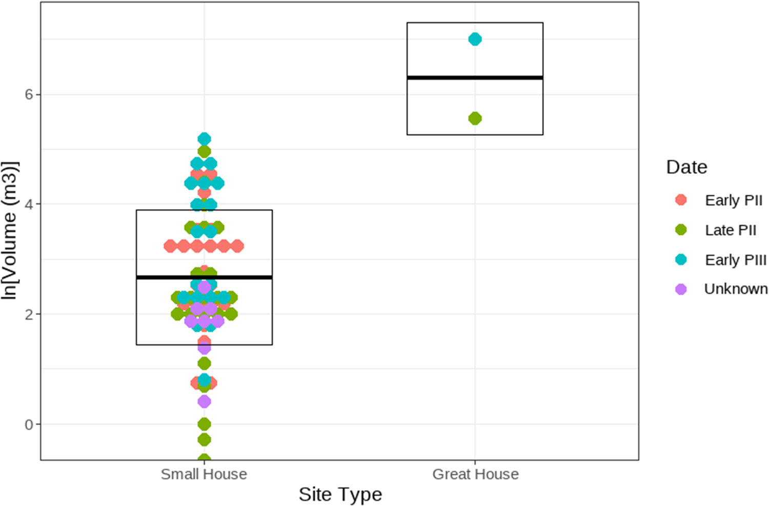
The Kin Nizhoni community consists of two Great Houses and a V-shaped distribution of 76 small-house structures around the base of a low mesa. There are two Great Houses in the Kin Nizhoni community—one dubbed Upper, one Lower (Figures 2 and 3a). Lower Kin Nizhoni contains a higher proportion of late Pueblo I and early Pueblo II (ca. AD 950–1050) ceramic types than Upper Kin Nizhoni, which has an assemblage characterized by mid-Pueblo II and early Pueblo III (ca. AD 1020–1100) types, suggesting that the former Great House slightly predates the latter (Tables 1 and 2; Marshall et al. Reference Marshall, Stein, Loose and Novotny1979:169–185). The temporal affiliation of the 76 small-house sites suggested by associated ceramics, around AD 1000–1000, spans the use of both Great Houses (Van Dyke Reference Van Dyke1998:166). Conservatively assuming that approximately half of the small houses in the Kin Nizhoni community were occupied at any given period of the site’s history and that a small house had four inhabitants on average, the community’s population at any given moment was likely around 150 people. The extent of domestic habitation in Great Houses, both within Chaco Canyon and throughout its larger world, is debated (Bernardini Reference Bernardini1999; Reed Reference Reed and Paul2008; Windes Reference Windes, Judge and Schelberg1984). Even if the Great Houses were not inhabited by families, the population estimates for Kin Nizhoni as a whole would likely decrease by only 10–15 people. As illustrated in Figure 4, there is significant disparity in the architectural investment in Great Houses at Kin Nizhoni compared with small-house structures, suggesting distinct social classes.
Dot plot showing the volumes (calculated as simple cubes, area x height) of small houses and Great Houses in the Kin Nizhoni Community. Figure by Scott G. Ortman. (Color online)

Great Houses, Earthworks, and Roads
Lower Kin Nizhoni is an L-shaped, single-story Great House containing three massive compound masonry rooms and a blocked-in kiva. Although its room count is low, Lower Kin Nizhoni is clearly distinguished from small houses in the community by its architectural massing (i.e., a mound height of approximately 2 m), room sizes (e.g., Room 1 is 8 × 4 m), and the presence of a blocked-in kiva. An enclosed plaza area extends off the room block to the south-southwest. At least three earthwork “middens”Footnote 1 of the type commonly found at outlier Great Houses—known in Chacoan archaeology by the Diné word nazha Footnote 2 (meaning “something curved” or “crescent”; Stein and Lekson Reference Stein, Lekson and David1992)—surround Lower Kin Nizhoni to the south and west. An especially massive (25 × 10 × 0.5 m) earthwork mound is present to the west of the Great House. At least two constructed roadways emanate from Lower Kin Nizhoni—the Lower Kin Nizhoni West Road (50 m long), which passes between the western earthworks, and the Kin Nizhoni Time Bridge Road, which links the Lower and Upper Kin Nizhoni Great Houses (490 m long). There are also two possible, but unconfirmed, roadways associated with Lower Kin Nizhoni: one suggested by the presence of a herradura (crescent-shaped shrines often associated with Chacoan roads; see Marshall Reference Marshall, Baker and Price1997; Nials et al. Reference Nials, Stein and Roney1987) 87 m south of the Great House, and another suggested by a break between the west and south earthworks.
The Upper Kin Nizhoni Great House is located 490 m northwest and uphill from Lower Kin Nizhoni and is connected to the latter structure by a constructed roadway known as the Kin Nizhoni Time Bridge Road. Given that Upper Kin Nizhoni’s associated ceramics date to the mid-eleventh and early twelfth centuries, it appears to have replaced Lower Kin Nizhoni as the community’s Great House (Marshall et al. Reference Marshall, Stein, Loose and Novotny1979:174, 178). The Upper Kin Nizhoni Great House was constructed of core-and-veneer masonry, stood two stories tall with a current mound height of 3 m, and is estimated to have contained 14 rooms (averaging 12 m2) in addition to its two blocked-in kivas. Upper Kin Nizhoni is completely encircled by low (ca. 20 cm tall) nazha earthwork mounds punctuated by breaks from which at least three roadways emanate: the Kin Nizhoni Time Bridge Road; the Kin Nizhoni East Road, which runs 3 km in the direction of San Mateo Great House; and the Kin Nizhoni West Road, which runs 287 m to terminate at a highly eroded masonry structure. In addition to the confirmed roads listed above, there is another possible road at Upper Kin Nizhoni, whose existence is suggested by a break in the southwestern portion of the earthworks. Yet another possible road, the Round Butte Road, is suggested by the presence of small shrine-like rooms flanking a 9 m wide swale on the western flank of the mesa behind Upper Kin Nizhoni. All these confirmed and possible roads are illustrated in Figures 2 and 3a.
Road Rooms, Box-Gate Complexes, and Herraduras
The Kin Nizhoni cultural landscape contains a variety of subtle, but significant, special-use architectural features identifiable as road rooms, box-gate complexes, and herradura shrines (Figures 2 and 3a). Road rooms are one- to three-room masonry structures built alongside Chacoan roadways or at their termination points that are differentiated from small-house structures by their lower mound relief, fewer rooms, lack of middens, and few associated artifacts (Weiner Reference Weiner2023:652–654). There are at least three road rooms at Kin Nizhoni: one at the terminus of the Kin Nizhoni West Road, and two that flank the possible Round Butte Road descending from the mesa top north of Upper Kin Nizhoni. Box-gate complexes consist of an approximately 1 × 1 m rectangular masonry alignment (“box”) often with an appended single-course masonry stone alignment (“gate”), which are common aspects of Chacoan road architecture and may have been constructed to prescribe ritual movement along roads (Weiner Reference Weiner2023:654–667). Box-gate complexes are appended to the northwestern corners of both the Upper and Lower Kin Nizhoni Great Houses; at Lower Kin Nizhoni, the box-gate complex marks the point where the Kin Nizhoni Time Bridge Road articulates with the Great House. Finally, four crescent-shaped, single-course masonry constructions that are readily identifiable as herraduras are present in the Kin Nizhoni cultural landscape. One is to the west of the Upper Kin Nizhoni Great House, one is due south (180°) of Upper Kin Nizhoni, a third is west-southwest of Upper Kin Nizhoni, and the fourth is south of Lower Kin Nizhoni (Figures 2 and 3a).
Cosmological Aspects
It is well established that materializing relationships with prominent landforms, directions, watery places, ancestral sites, and astronomical bodies through the construction of Great Houses and roads formed a central component of Chacoan religion and architectural practice (Fowler and Stein Reference Fowler, Stein and David1992; Kantner Reference Kantner1997; Lekson Reference Lekson2015; Marshall Reference Marshall, Baker and Price1997; Sofaer Reference Sofaer and Stephen2007; Van Dyke Reference Van Dyke2008; Weiner Reference Weiner2023). Van Dyke (Reference Van Dyke2008) has also emphasized evidence for balanced dualism, cyclical renewal, and concepts of center place as integral to Chacoan religious discourse. The design of Kin Nizhoni’s ritual landscape presented below is resonant with these general patterns evidenced at Chaco Canyon and throughout its larger world.
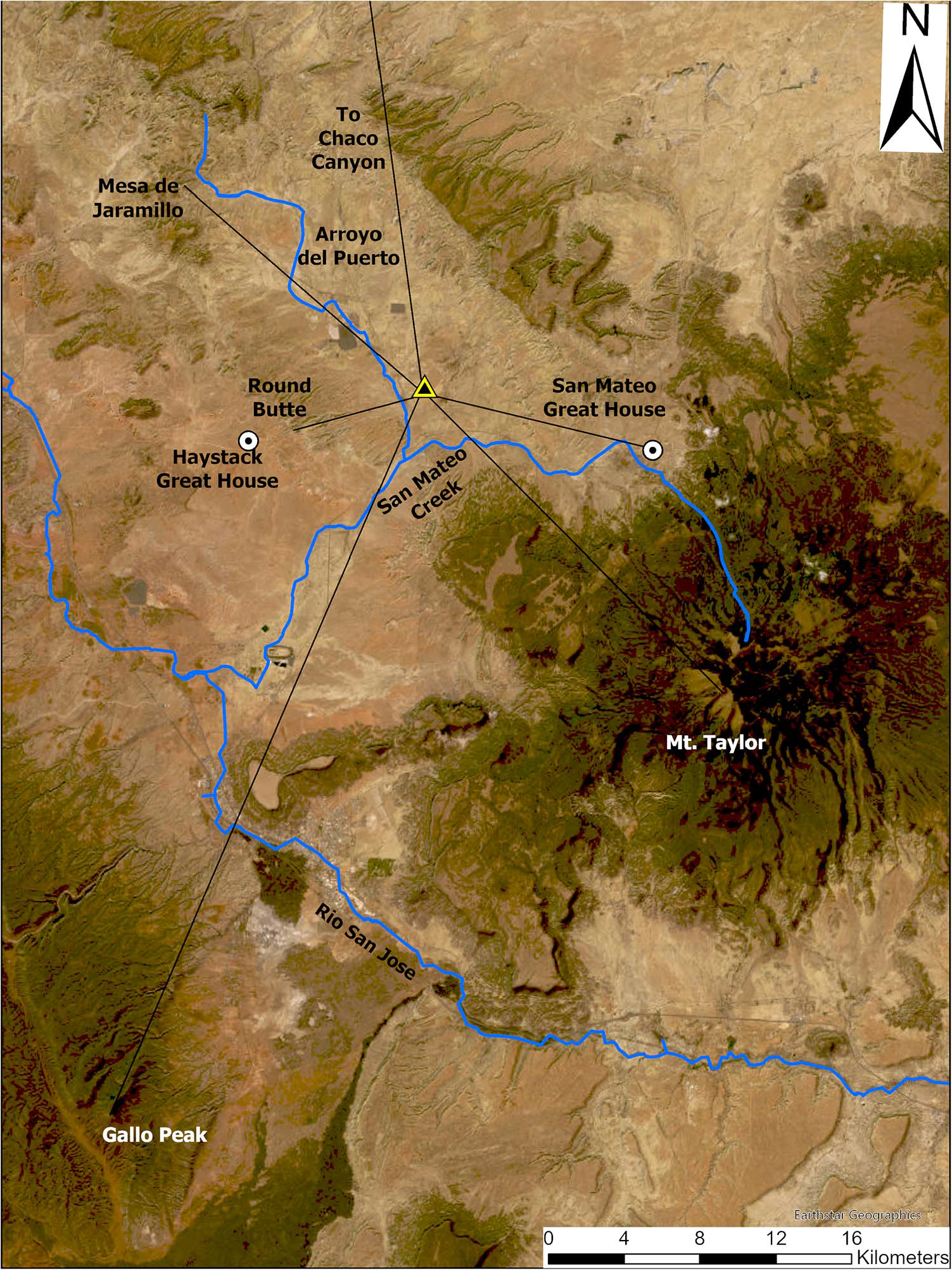
Kin Nizhoni is situated in a locale that affords views of prominent mountains in multiple directions: Mount Taylor to the south/southeast, Jesus Mesa to the east, Gallo Peak to the southwest, Mount Sedgwick to the southwest, Round Butte to the west, and Mesa de Jaramillo and Little Haystack to the northwest (Figures 3a and 5). The Chacoan builders of Kin Nizhoni materialized alignments toward some of these landforms through the construction of excavated roadways, conspicuous gaps in the nazha earthworks, and the layout of the two Great Houses. Mount Taylor looms massively on Kin Nizhoni’s southeastern horizon, and the alignment between the Upper and Lower Great Houses, marked by a road, is also in line with Mount Taylor (Figure 3b). The Kin Nizhoni West Road forms a clear visual alignment with Mount Sedgwick, the high point in the Zuni Mountains. Additionally, the Lower Kin Nizhoni West Road and a road framed by two road rooms north of Upper Kin Nizhoni both align with Round Butte, a small prominence on the western horizon. Breaks in the nazha earthworks surrounding both Upper and Lower Kin Nizhoni frame Gallo Peak on the southwestern horizon, though there are no unequivocal ground signatures of a road along either route. However, numerous confirmed roads at Kin Nizhoni and other outlier Great Houses throughout the Chaco World emanate from breaks within nazha (Stein and Lekson Reference Stein, Lekson and David1992), and even if the alignments toward Gallo Peak were not formalized through the construction of a road, the presence of a gap in earthworks framing the mountain represents an architectural marking of the relationship. Overall, the use of roadways to mark alignments from the Upper and Lower Kin Nizhoni Great Houses with prominent mountains in multiple directions would appear to reflect concepts of the site as a center place, much like Chaco Canyon itself (Marshall Reference Marshall, Baker and Price1997; Van Dyke Reference Van Dyke2008), while also marking relationships between the Great Houses and spiritual forces associated with mountains.
Regional view of Kin Nizhoni’s relationships to landforms marked by alignments. The triangle marks the site location. Map by Robert S. Weiner. (Color online)

Upper and Lower Kin Nizhoni—noncontemporaneous Great Houses—are connected by the Kin Nizhoni Time Bridge Road, which also aligns with Mount Taylor from the vantage of Upper Kin Nizhoni. Fowler and Stein (Reference Fowler, Stein and David1992) have discussed various locales throughout the Chaco World where noncontemporaneous Great Houses were connected by roadways, which they call “time bridges” or “umbilicals through time.” Most time-bridge roads appear to have been constructed in the thirteenth and fourteenth centuries, however, and therefore postdate the Chaco era (Fowler and Stein Reference Fowler, Stein and David1992:116–118; but see the Red Willow–Los Rayos Road discussed by Van Dyke Reference Van Dyke, Ruth and Susan2003). In contrast, the Kin Nizhoni Time Bridge Road was likely constructed concurrent with the establishment of the Upper Kin Nizhoni Great House in the late eleventh century during the Chaco era. Constructing time-bridge roads was a form of landscape architectural practice through which Chacoans materialized connections with previous eras for religious and political purposes (Fowler and Stein Reference Fowler, Stein and David1992; Lekson Reference Lekson2015; Van Dyke Reference Van Dyke, Ruth and Susan2003). The pairing of Upper and Lower Kin Nizhoni, as well as the presence of two kivas within Upper Kin Nizhoni, also suggest expressions of balanced dualism at the site (sensu Van Dyke Reference Van Dyke2008).
Multiple lines of archaeological evidence underscore marking of the direction northwest (and by extension, the northwest–southeast axis) at Kin Nizhoni. Chacoan Great House and road architecture evidence a clear interest in cardinality and intercardinal directions of astronomical significance—specifically, solstices and lunar standstills (Marshall Reference Marshall, Baker and Price1997; Sofaer Reference Sofaer and Stephen2007). First, Upper Kin Nizhoni was constructed to the northwest of the earlier Lower Kin Nizhoni Great House. Second, box-gate complexes are appended to the northwest corners of both Upper and Lower Kin Nizhoni Great Houses, the only architectural annexes to either Great House. Additionally, a gap in the nazha at Upper Kin Nizhoni frames Mesa de Jaramillo, a prominent landform on the northwestern horizon, and although they are not visible, Hosta Butte and Chaco Canyon are also located to the northwest. As noted above, Mount Taylor stands prominently on the site’s southeastern horizon. Consequently, rather than cardinal directions, the cosmography of Kin Nizhoni appears focused on intercardinals. More general marking of intercardinal directions or diagonals is evidenced in the architecture of Chaco Canyon Great Houses, some of which are designed with geometrical proportions such that their diagonals form astronomical or cardinal alignments complementary to their principal axes (Sofaer Reference Sofaer and Stephen2007:236–237, Table 9.8).
Roads at Kin Nizhoni also materialized social relationships between contemporaneous communities, a finding that corresponds with Vivian’s (Reference Vivian1997:50) proposal that some Chacoan roads “functioned to maintain both real and symbolic unification of . . . great house populations.” The Kin Nizhoni East Road runs 3 km toward the San Mateo Great House community (located 12.4 km away). Although the road’s surface signature is not continuous along the entire length between the sites, it almost certainly connected them—or at least physically expressed their association on the landscape. The Kin Nizhoni East Road also trends in the general direction of Jesus Mesa (an important landform to Pueblo people today), although its alignment passes well to the south. The Lower Kin Nizhoni West Road’s and possible Round Butte Road’s alignments toward Round Butte also may have indexed relationships with the Haystack Great House community 9.6 m to the west. A canyon runs through the mesa atop which Round Butte sits just north of the butte, which offers the sole passage through the mesa. This canyon exits into the flats directly in line with Haystack Great House. Consequently, alignments toward Round Butte may simultaneously (or even principally) demarcate an alignment toward this natural passageway and the neighboring Haystack Great House on its other end.
Wiyo’owingeh (ca. AD 1275–1400)
Turning now to the more recent, post-Chaco community, Wiyo’owingeh (LA 158, “wide gap village place”) is an ancestral Tewa community located on the western slopes of the Sangre de Cristo Mountains, near present-day Cordova, New Mexico. The ancestral village includes three house mounds, which are arranged with different orientations at the northern edge of a small mesa overlooking the Rio Santa Cruz Valley to the south and the larger Rio Grande Rift Valley to the west (Figures 6 and 7). Today, a highway passes between the mounds. The western and southeastern mounds are largely intact, but the northeastern mound has been impacted by adobe mining. Based on the associated surface ceramics, the settlement was inhabited for approximately 125 years, from AD 1275 to 1400 (Table 3).
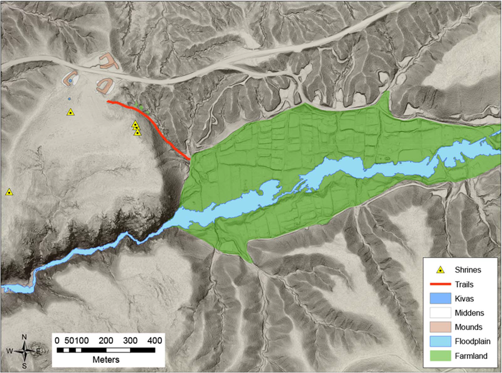
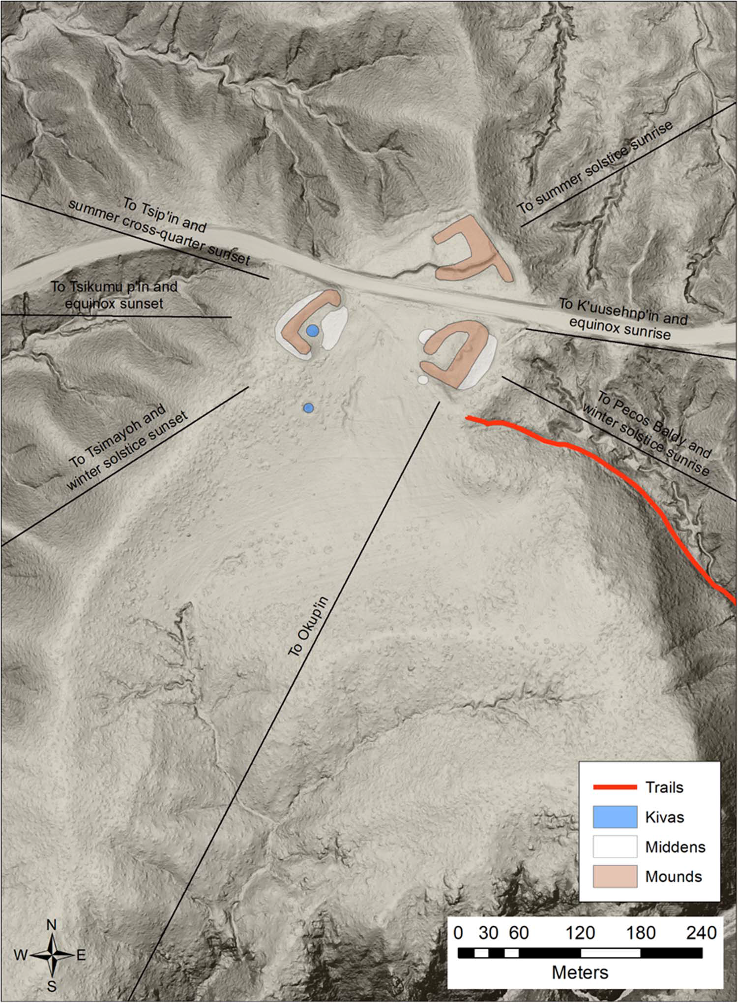
Wiyo’owingeh community pattern. Note the trail down to the primary farming area, a valley adjacent to the Rio Santa Cruz floodplain, which is under acequia irrigation today. The World Quarter Shrine is the feature about 0.5 km southwest of the village center. Map by Scott G. Ortman. (Color online)

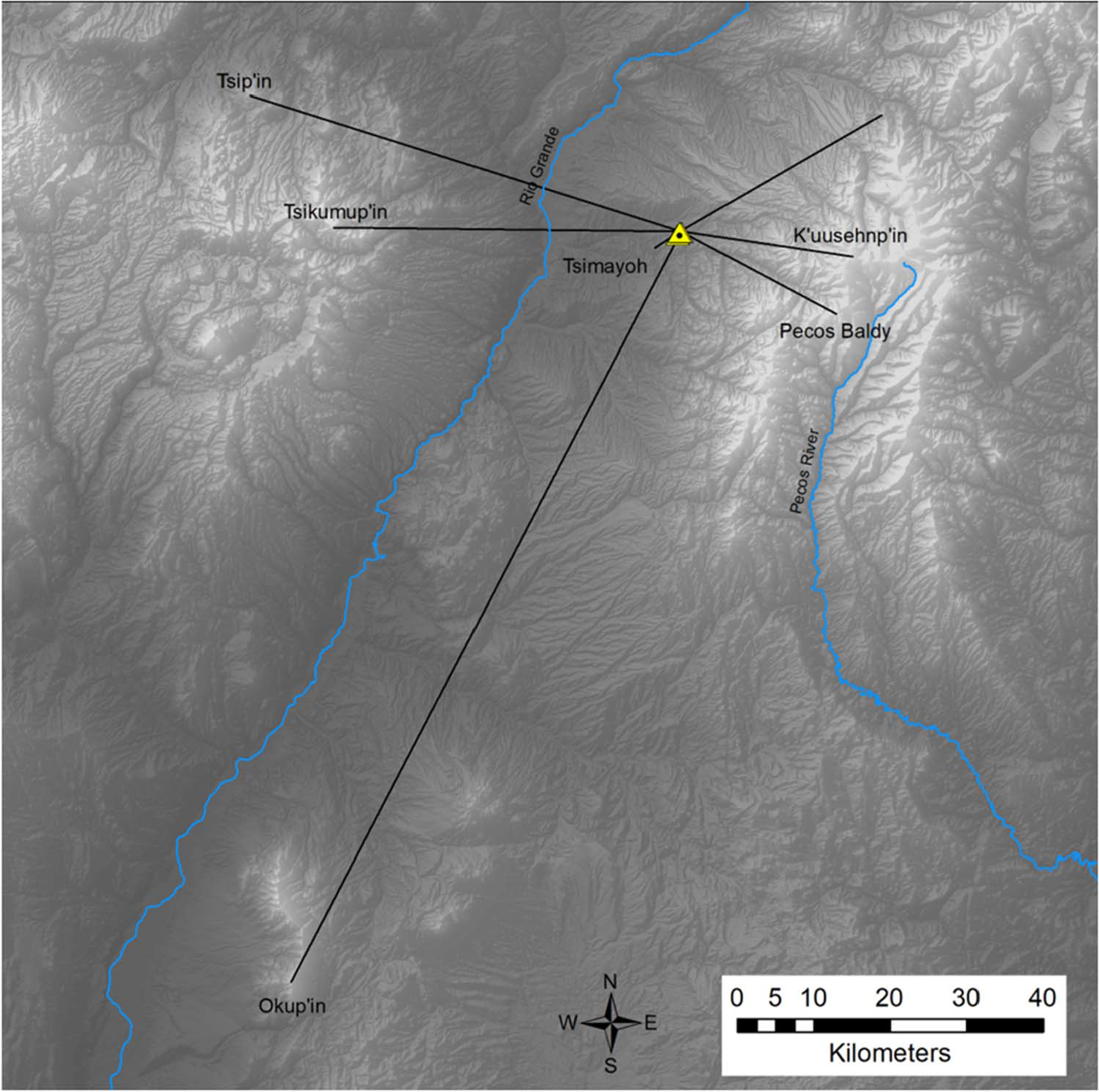
Regional view of Wiyo’owingeh’s significant orientations to landforms and horizon events. The triangle marks the site location. Map by Scott G. Ortman. (Color online)

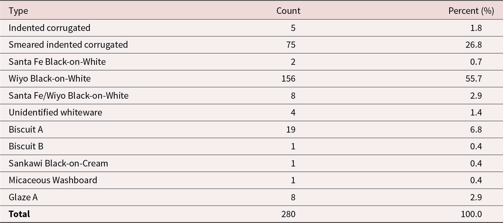
Marshall and Walt’s (Reference Marshall and Walt2007) Sample Tabulation of Surface Pottery Associated with the Three House Mounds at Wiyo’owingeh.

History of Research
The earliest mention of Wiyo’owingeh in print occurs in John P. Harrington’s Ethnogeography of the Tewa Indians (Reference Harrington1916:344). He was not able to locate the ancestral site itself, listing it as one of the unlocated places on his Map 22 of the Santa Fe Mountain Region, but he noted that it was named after a prominent gap in the Sangre de Cristo Mountains, and that it was located at or near this gap. He also reported,
This pueblo plays an important role in one version of the Tewa migration legend. It was built, so it is related, by the united Summer and Winter people after they had wandered separated for generations. It was here that two-cacique government was first instituted [Harrington Reference Harrington1916:357].
According to Harrington, residents of San Juan (Ohkay Owingeh), San Ildefonso, and Nambé were all aware of this site at the turn of the twentieth century. H. P. Mera (Reference Mera1934) subsequently located Wiyo’owingeh during his survey of the Biscuit Ware area in northern New Mexico. He considered the surface pottery at this site to be characteristic of the transition between earlier matte-painted wares and later Biscuit wares, and he used the Tewa name of this site to label this transitional pottery Wiyo Black-on-White:
Laboratory of Anthropology site L.A. #158, Wiyo, taken as the type site, lies near the present village of Cordova, New Mexico, and is one in which the changes from an earlier black-on-white pottery through Wiyo Black-on-white to a fully developed biscuit ware can be demonstrated [Mera Reference Mera1934:9].
In 2007, Marshall and Walt revisited LA 158 as part of their study of Ohkay Owingeh traditional use of the Santa Cruz watershed, during which they made a map of the three major mounds and associated features (Marshall and Walt Reference Marshall and Walt2007:Figure II-8), tabulated a sample of surface pottery associated with each mound, and reexamined Mera’s collection from the site at the Laboratory of Anthropology (Marshall and Walt Reference Marshall and Walt2007:Table A.7). The pottery assemblage they tabulated is dominated by Wiyo Black-on-White, Biscuit A, and Smeared Indented-Corrugated Gray Ware, with only trace occurrences of other types (Table 3). This is consistent with a relatively brief occupation between AD 1275 and 1400. For unknown reasons, Marshall and Walt accepted Mera’s identification of the site as LA 158 but refrained from associating this location with the Tewa name, choosing instead to refer to it as Pueblo Quemado (Marshall and Walt Reference Marshall and Walt2007:A-32). All evidence from the site, including the additional information presented below, supports the identification of LA 158 as Wiyo’owingeh.
Since 2011, Ortman has visited Wiyo’owingeh several times with Tewa elders. During these visits, the groups relocated and checked Marshall and Walt’s interpretations of the southeastern and western mounds and examined relationships between the architectural features and named Tewa landforms visible from the site. Ortman has also matched and georeferenced Marshall and Walt’s (Reference Marshall and Walt2007) map of the room blocks and features to a digital elevation model (DEM) derived from recent lidar coverage, downloaded from the US Geological Survey. These activities confirmed the shapes of the southeastern and western mounds while adjusting their sizes and orientations and clarified the original morphology of the northeastern mound, as discussed below.
Community Pattern
The community pattern at Wiyo’owingeh is presented in Figures 6 and 7. The architectural remains consist of three massive house mounds that appear to represent three stories of melted adobe rooms from apartment-style dwellings. The southeastern and western mounds are largely intact, so georeferencing to the lidar-based DEM simply involved adjusting their orientations and aerial extents. The northeastern mound, in contrast, has been heavily disturbed, as Marshall and Walt (Reference Marshall and Walt2007:A-34) explain:
The North Pueblo has been extensively disturbed by mining earth for adobe block manufacture and by the former removal of fill dirt for highway construction. Inspection of the 1935 Soil Conservation Service aerial photography of the site area indicates that this pueblo consisted of a large room block with an enclosed plaza area to the northwest. The North Pueblo was somewhat larger than the East and West pueblos. The plaza, which was defined by a deep depression, may have been open to the southwest. The North Pueblo was at least the size of the West Pueblo and encompassed perhaps 4,000 m2. It probably had 300 ground-floor rooms or more and perhaps 100 upper-story rooms.
In their site map, Marshall and Walt (Reference Marshall and Walt2007:Figure II-8) fit an inferred mound of identical size and shape to the southeastern mound within the portion of the site north of the highway. The lidar-based DEM, however, captures enough traces of this mound to allow a more concrete reconstruction. The DEM shows that the northeastern mound has been graded flat, with portions being removed by front-end loaders working from the road to the south. Nevertheless, topographic traces remain beneath the graded and removed portion, and these support a reconstruction of a C-shaped room block with a central plaza, open to the southwest as suggested by the 1935 aerial photos, and with a small linear extension to the southeast.
Collectively, the three georeferenced mounds encompass 5,482 m2. This is quite a bit less than the 9,125 m2 suggested by Marshall and Walt (Reference Marshall and Walt2007) from on-the-ground observations, but the height of the mounds, combined with the relatively short occupation span, is nevertheless consistent with multistory house blocks. Based on Duwe and colleagues’ (Reference Duwe, Eiselt, Darling, Willis and Walker2016) pueblo decomposition model, the estimated mound areas represent 244 ground-floor rooms, 122 second-story rooms, and 61 third-story rooms, for a total of 426 rooms. Due to the brief occupation suggested by the associated pottery assemblage, it is likely that all were inhabited simultaneously. Based on the conversion of one person per occupied room (Ortman Reference Ortman2016), these data suggest that the village was home to approximately 425 persons during the fourteenth century.Footnote 3
Each of the house mounds at Wiyo’owingeh defines internal courtyards, and a kiva depression is apparent within at least one of these—in the west mound. There are also clear concentrations of ashy soil and artifacts around the perimeters of the western and southeastern mounds. There were likely once similar concentrations around the northeastern mound as well. An additional kiva depression is visible to the south of the western mound.
Marshall and Walt (Reference Marshall and Walt2007:C2–10) surveyed public lands surrounding Wiyo as part of their study, leading to the identification of several shrines in various locations surrounding the residential area. These include several granite boulders along the eastern edge of the mesa with ground slicks and pecked and ground cupules (Duwe Reference Duwe2016); a small ring of stones to the south of the residential area that may reflect ongoing visits to the site by Tewa descendants; and a 12 m diameter stone circle, with a gap in the stones facing east, about 500 m to the southwest (Marshall and Walt Reference Marshall and Walt2007:C-2). This last feature is of the type commonly referred to as a World Quarter Shrine (Duwe Reference Duwe2020; Jeançon Reference Jeançon1923). All these features are at locations with fine views of the surrounding landscape and horizons. Wiyo’owingeh represents one of just a few Northern Rio Grande sites at which such features can be confidently dated to the late thirteenth to fourteenth century (Ortman Reference Ortman2012:314). Additional examples include T’aitöna (Pot Creek Pueblo) north of Picuris Pueblo (Fowles Reference Fowles2009) and Tsipin’owingeh near Abiquiu Lake (Duwe Reference Duwe2020:134–135). Importantly, such features do not occur in association with Northern Rio Grande sites vacated prior to the late thirteenth century. Many lines of evidence suggest that there was an influx of emigrants from the Northern San Juan drainage into the Tewa Basin at this time (Clark et al. Reference Clark, Birch, Hegmon, Mills, Glowacki, Ortman and Dean2019; Ortman Reference Ortman, Kelly and Christopher2020). The fact that this complex of ritual features is found in association with earlier sites in the Northern San Juan—but is absent at earlier sites in the Northern Rio Grande—suggests these practices were brought to the region by Northern San Juan migrants (Fowles Reference Fowles, Adams and Duff2004; Ortman Reference Ortman2012:312–319). These migrants were descendants of people who had participated in the Chaco World, as had the residents of Kin Nizhoni.
The residential area of Wiyo’owingeh was adjacent to a patch of well-watered agricultural land in the Rio Quemado Gorge, through which the Rio Santa Cruz flows about 600 m to the southeast. This land is still utilized for small-scale agriculture today. A US Forest Service road, visible in the lidar imagery, connects this patch of land to Wiyo and the old adobe-mining area. As this path follows a drainage down the slope, we suspect it began as a trail that linked the residential area of Wiyo to nearby agricultural lands. This low-lying area encompasses 49 ha, or about 0.1 ha per resident of Wiyo’owingeh. Early twentieth-century Tewa communities appear to have utilized about 0.5 ha of agricultural land per person (Anschuetz Reference Anschuetz2007). This suggests that most of the food supply was generated beyond this irrigated patch, either along the Rio Santa Cruz or via precipitation-based farming in adjacent uplands. Indeed, land pressure and cold-air drainage may well have been factors in the short occupation of Wiyo’owingeh.
Cosmological Aspects
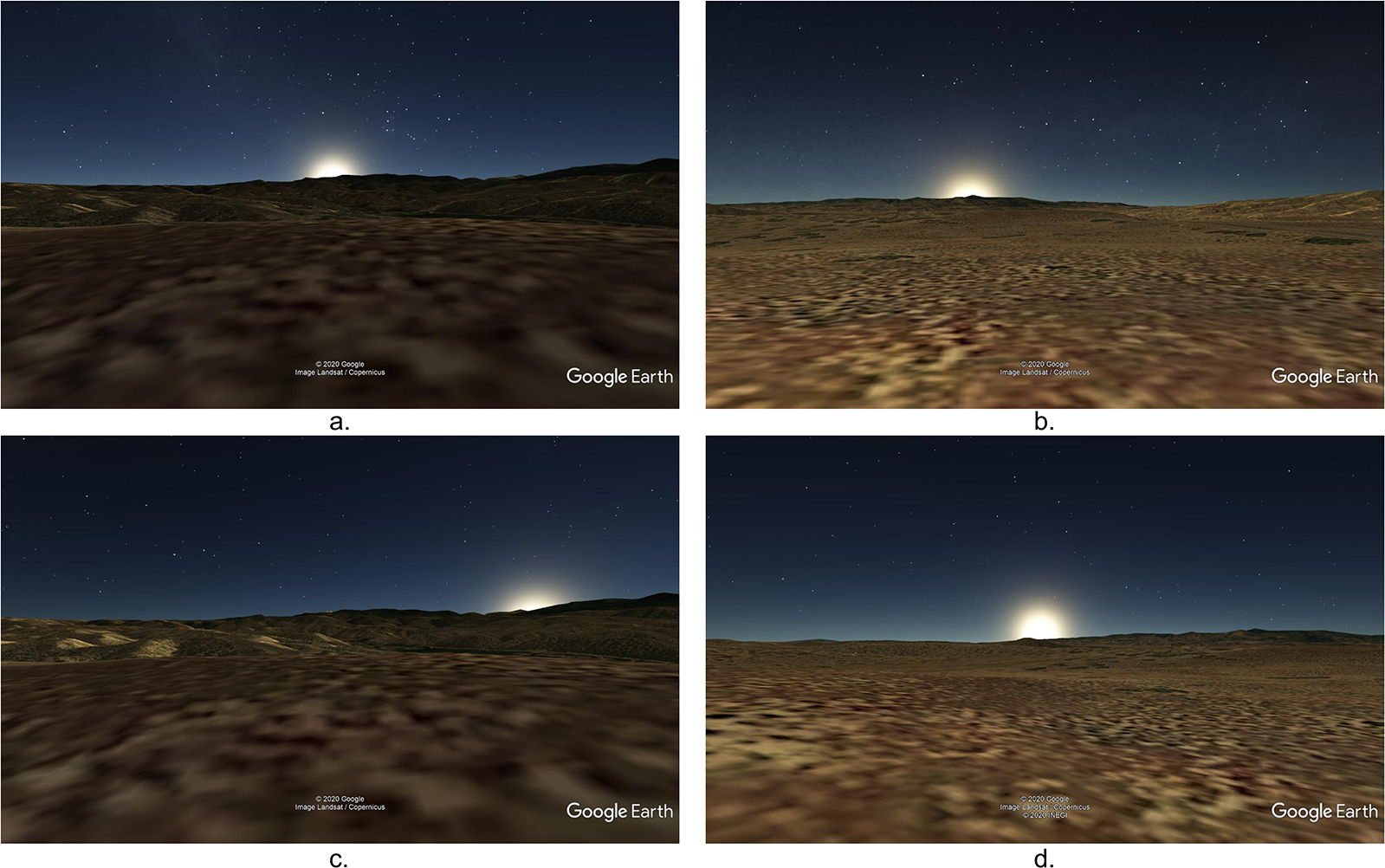
Through site visits and discussions with Tewa community members, we have noted several relationships between buildings, Tewa cultural landscape features, astronomical events, and Tewa social organization at Wiyo’owingeh. These details resonate with the oral tradition recorded by Harrington (Reference Harrington1916). Figures 8a–d and 9 illustrate the orientations to several important horizon events and named Tewa landforms from the site location. We begin with relationships between astronomical events and landscape features. Today, Tewa people define their homeland as being within the viewsheds of four prominent directional peaks: Sayshup’in “Eagle Beak Mountain” (Antonito) in the north (p’inpiye, “toward the mountains”); Tsikumup’in “Flaking-stone Covered Mountain” (Chicoma) in the west (Tsampiye, “toward yesterday”), Okup’in “Turtle Mountain” (Sandia) in the south (Akompiye, “toward the plains”), and K’uusehnp’in “Stone Horn Mountain” (Truchas) in the east (Thanpiye, “toward the sun”).Footnote 4 Wiyo’owingeh is in a location where the sun happens to rise behind the East Mountain (Figure 8a) and set behind the West Mountain (Figure 8b) on the equinoxes. The orientation to the sunrise is slightly south of due east given the vertical angle to Truchas Peak from the site location. This detail is important because it suggests that the builders were aware of the equinox as the day the sun rises due east on a flat plane, but they placed the settlement in such a position that it marked the observed relationship between the sunrise and the mountain on this day (see Barnhart and Ortman [Reference Barnhart, Ortman, Munson, Bostwick and Hull2014] for a similar arrangement at a Northern San Juan village). The vertical angle to the west horizon, on the other hand, is closer to zero, leading to a more direct correspondence between the abstract concept of the equinox and the setting sun behind the West Mountain.
Google Earth ground-view simulations of astronomical events as viewed from Wiyo’owingeh: (a) equinox sunrise behind K’uusehnp’in (Truchas Peak); (b) equinox sunset behind Tsikumup’in (Chicoma Peak); (c) winter-solstice sunrise behind Pecos Baldy; (d) winter-solstice sunset behind Tsimayoh. Figure by Scott G. Ortman and Robert S. Weiner. (Color online)

Detail of Wiyo’owingeh showing orientations from house mounds to Tewa cultural landforms and horizon events. Shrine locations have been removed from this view. Map by Scott G. Ortman. (Color online)

In addition, the rising and setting positions of the sun at winter solstice are significant. From this location, the winter solstice sunrise is behind a peak known today as Pecos Baldy on the southeast horizon (Figure 8c), and it sets behind a prominent hill, Tsimayoh, to the southwest (Figure 8d). Harrington (Reference Harrington1916:354) does not relate a Tewa name for Pecos Baldy, but it surely had a Tewa name at the time of Wiyo’s occupation. There are caves associated with Tsimayoh, and in some versions of Tewa tradition, there are ogres living in these caves who emerge in midwinter to punish community members who have been behaving badly (Ortiz Reference Ortiz1969). Today, the Santuario de Chimayo lies at the foot of this hill, and the hill gives the village its name (Wroth Reference Wroth, Gavin and Pierce2021). Finally, Okup’in, the South Mountain, is visible on the southern horizon from Wiyo, and Tsip’in is visible to the northwest. The cross-quarter summer sunsets (early May and early August) occur behind the latter landform when viewed from Wiyo’owingeh.
Figure 9 illustrates how these orientations interact with the arrangements of the house mounds at Wiyo’owingeh. The most important observation is that the three mounds are arranged and oriented in such a way that, when viewed from the west mound, the summer sun rose behind and aligned with the northeast mound; the winter sun rose behind and aligned with the southeast mound and Pecos Baldy; and at the equinoxes, the sun rose in between the two mounds, centered on K’uusehnp’in. The implication of this arrangement is that the northeast mound, which had a major wall perpendicular to the midsummer sunrise, also faced the midwinter sunset behind Tsimayoh; and the southeast mound, which had a major wall perpendicular to the midwinter sunrise, also faced the midsummer sunset to the north of Tsip’in. Based on these relationships, it is possible to consider the northeast mound as having been associated with the morning and daytime during the summer season, and with the evening and nighttime during the winter season; and the southeast mound as having been associated with the morning and daytime during the winter season, and the evening and nighttime during the summer season. Notice also that, in addition to being perpendicular to the midwinter sunrise, the major axis of the southeast mound is aligned with the view to Okup’in, the South Mountain.
These details provide a direct connection between the landscape, traditional Tewa social organization, and oral traditions associated with Wiyo’owingeh. Traditional Tewa communities are divided into two groups, the Summer People and the Winter People, each of which has a chief who oversees the entire community during the corresponding season. According to Tewa tradition, the first Summer Chief and Winter Chief were initiated by the Hunt Chief, the first paat’owa, or Made Person, who was himself initiated by the predatory animals and carrion birds. These events happened when Tewa ancestors lived in the distant north, in their ancestral homeland (Ortiz Reference Ortiz1969; Parsons Reference Parsons1964, Reference Parsons1994). When the people decided to leave the ancestral homeland and migrate southward, the two groups migrated separately, with the Winter People subsisting on wild plants and hunted game, and the Summer People subsisting on agricultural produce. During these migrations, the Winter People and Summer People each created their own villages, until they eventually came together in communities containing both Summer and Winter People. Today, the Summer Chief is in charge for a longer period than the Winter Chief, most likely due to the addition of winter wheat to the Tewa agricultural economy in recent centuries (Ortiz Reference Ortiz1969). However, several lines of evidence suggest that in precolonial times, the equinoxes marked the transitions in leadership between the two seasonal chiefs (see Ortman Reference Ortman and Peter2018:58).
In recent years, Ortman and colleagues have identified two ancestral Tewa communities where paired initial villages coalesced into a single later village, parallel to the merging of the Summer and Winter People in Tewa tradition. K’uuyemugeh, an early 1200s village on the southern of two terraces, was joined by a second village on the northern terrace in the late 1200s, and this paired village community merged into a single, dual-plaza community on the southern terrace in the 1400s (Bernstein and Ortman Reference Bernstein and Ortman2020). And at Tsama’owingeh, paired villages were built in the mid-to-late 1200s, with residents of the western village joining the eastern village to create a single, large, plaza-oriented community in the 1400s (Davis and Ortman Reference Davis and Ortman2021).Footnote 5 Wiyo’owingeh does not present a paired village community that coalesced into one over time. Instead, it presents a community containing clear summer- and winter-associated house mounds in the northeast and southeast, under the supervision of a third mound to the west. Based on the community pattern, it is possible to associate the Summer People with the northeastern mound, the Winter People with the southeastern mound, and perhaps the primordial paat’owa—or Made People—with the western mound.
The creators of Wiyo’owingeh clearly viewed it as important to situate the community in the surrounding landscape, orienting and acknowledging relationships between the earth and sky and connecting the rhythms of social life to these relationships. When viewed from the western mound, the rising summer sun rose behind the northeastern mound, and the setting sun faced the southeastern mound, indicating that the northeastern mound was dominant and the southeastern mound was subordinate. During the winter season, the situation was reversed. These connections show that Tewa ancestors looked to the natural world for models of a properly functioning human community and manifested these models by connecting human residences to the surrounding landscape. The interaction of the rising sun with the eastern house mounds indicated which of the two seasonal chiefs was waxing, the interaction of the setting sun and these mounds indicated which of the two was waning, and the passage of the sun between the East and West mountains indicated change of seasons and associated leadership. During these times of year, the sun was literally tepingeh, “in the middle of the structure.”
Comparisons
The most obvious distinction between Kin Nizhoni and Wiyo’owingeh is the presence of a Great House in the center of the Kin Nizhoni community that serves as the focal point of constructed articulations with the broader landscape. Evidence from Pueblo Bonito in Chaco Canyon suggests that Great Houses were associated with elite lineages whose members were afforded special privileges in Chacoan society (Kennett et al. Reference Kennett, Plog, George, Culleton, Watson, Skoglund and Rohland2017; Plog and Heitman Reference Plog and Heitman2010). Even if the elite associations evidenced at Pueblo Bonito do not hold for all Great Houses across the Chaco World, the monumental architecture and associated artifact assemblages of Great Houses nevertheless clearly distinguish them from the everyday dwellings (i.e., unit pueblos) in Great House communities (e.g., Figure 4). In addition to other possible uses, the Kin Nizhoni Great House clearly served as the focal point for materialized articulations with the surrounding sacred landscape via constructed earthworks and monumental roadways.
Both sites incorporate relationships with prominent mountains, but in different ways. Kin Nizhoni’s constructed earthworks and roads mark alignments between exclusive Great House structures and prominent landforms and other Chacoan settlements. These relationships suggest that in the Chaco era, residents of Great Houses had more direct association with—and perhaps access to—sacred landforms than did other members of the community. At Wiyo, in contrast, relationships with prominent mountains, equinoxes, and solstices are focused on the aggregated, communal dwellings, suggesting a leveling of Chaco-era differences. Additionally, the relationships between the built environment and larger cultural landscape are more explicitly marked at Kin Nizhoni, taking the form of monumental roads etched into the earth’s surface. Alignments are more implicit at Wiyo: sacred mountains and astronomical events are visible from the community dwellings and referenced through the structures’ general orientations, but they are not overtly marked through roads or earthworks. Astronomical relationships, specifically to equinoxes, are pronounced in the design of Wiyo, whereas astronomical alignments are not clearly evinced at Kin Nizhoni. Of course, astronomical principles structured the orientations of many Chacoan Great Houses (Sofaer Reference Sofaer and Stephen2007), so although they are not present at Kin Nizhoni, the importance of marking relationships with the sun at Wiyo can still be seen as a continuation of Chaco-era cosmographic principles.
Constructed infrastructure at the two sites contrasts markedly. Roads at Kin Nizhoni are monumental in scale, measuring 9 m wide on average, and they materialize connections: between the Upper and Lower Great Houses, between both Great Houses and prominent landforms, and between Kin Nizhoni and other Chacoan communities. Kin Nizhoni’s roads therefore expressed a relationship between Great Houses, their inhabitants, and sacred landforms; materialized the lineal connection of Great House structures (i.e., overt marking of continuity with the past); and evoked the existence of a greater Chacoan community beyond the bounds of the Kin Nizhoni settlement. In contrast, the inferred trail at Wiyo is more modest in scale, certainly no wider than the current 2 m wide Forest Service road, and it led from the residential area to agricultural fields. The labor investment necessary to create Chacoan roads far outweighed that needed for the Wiyo trail. In short, the two sites suggest a shift from overt, labor-intensive material expressions of ideological concepts at Kin Nizhoni to more subtle expressions at Wiyo, with more communal labor being invested in agricultural infrastructure in the latter case.
Dual pairing of buildings appears to have served as a structuring principle for the design of both sites. At Kin Nizhoni, the paired structures take the form of Upper (northwest) and Lower (southeast) Great Houses connected by a road. Upper Kin Nizhoni also contains two blocked-in kivas, an architectural expression that Whiteley (Reference Whiteley, Carrie and Plog2015) suggests represents dual social organization and that Van Dyke (Reference Van Dyke2008) associates with a more general Chacoan cosmological principle of balanced dualism. At Wiyo, the western house mound is set in contrast to paired southeastern and northeastern mounds. Although the principle of paired structures is shared, the evidence suggests that such arrangements had a different significance in the two contexts. At Kin Nizhoni, the paired Great Houses were not used contemporaneously, but they remained connected by a monumental road that explicitly expressed continuity between the two and implied their temporal relationship via an orientation toward the southeast (i.e., the general direction of sunrise in mid-winter), the beginning of the year. In contrast, Wiyo’s paired structures are contemporaneous dwellings, one likely being associated with the Winter People (moiety), and the other with the Summer People (moiety). That said, temporal relationships between community buildings have been observed at K’uuyemugeh and Tsama’owingeh, where there is evidence for earlier, paired summer–winter buildings coalescing into a single community over time (Bernstein and Ortman Reference Bernstein and Ortman2020; Davis and Ortman Reference Davis and Ortman2021). Overall, the different manifestations of dualism in cultural landscape design at Kin Nizhoni and Wiyo is consistent with the idea that kin-based organizations dominated Chaco society, and these were increasingly supplanted by non-kin-based organizations in post-Chacoan Pueblo history (Ortman Reference Ortman2012, Reference Ortman and Peter2018; Ware Reference Ware2014).Footnote 6
The two sites also differ in the extent to which they manifestly express connections to other communities. The Kin Nizhoni East Road physically connects the settlement with the Great House community of San Mateo 12.4 km away. Similarly, the Kin Nizhoni West Road’s and Round Butte Road’s orientations align toward the Haystack Great House 9.6 km away. The notion of an integrated Great House regional community was therefore materially marked through the construction of road segments (cf. Vivian Reference Vivian1997:50). In contrast, although overt materializations of intercommunity connections are less evident at Wiyo than at Kin Nizhoni, ethnohistoric documentation by Spanish explorers suggests that residents of Wiyo did in fact view themselves as part of an ethnolinguistic “Tewa Nation” (Barrett Reference Barrett2002). Our interpretation of the differential degree of materialization is that the idea of a regional community was relatively new and required explicit material support (e.g., in the form of monumental roads) during the Chaco era. By the AD 1300s, however, the idea had become sufficiently ingrained that direct and explicit marking was no longer required. Instead, communities could express their common identity by relating community buildings to shared sacred landforms.
Overall, the cosmological ideas manifested through Kin Nizhoni and Wiyo’owingeh’s built environments were much more similar than were their articulations with very different social fabrics. It appears that concepts and practices that had initially developed to express the preferential access of specific lineages to sacred landforms and the forces of nature were reimagined during the post-Chaco transition to express shared access of more inclusive community institutions to these forces. As we argue below, the World Quarter Shrines at later Pueblo sites in the Rio Grande—such as Wiyo’owingeh—are crucial for understanding this transformation.
Discussion and Conclusion
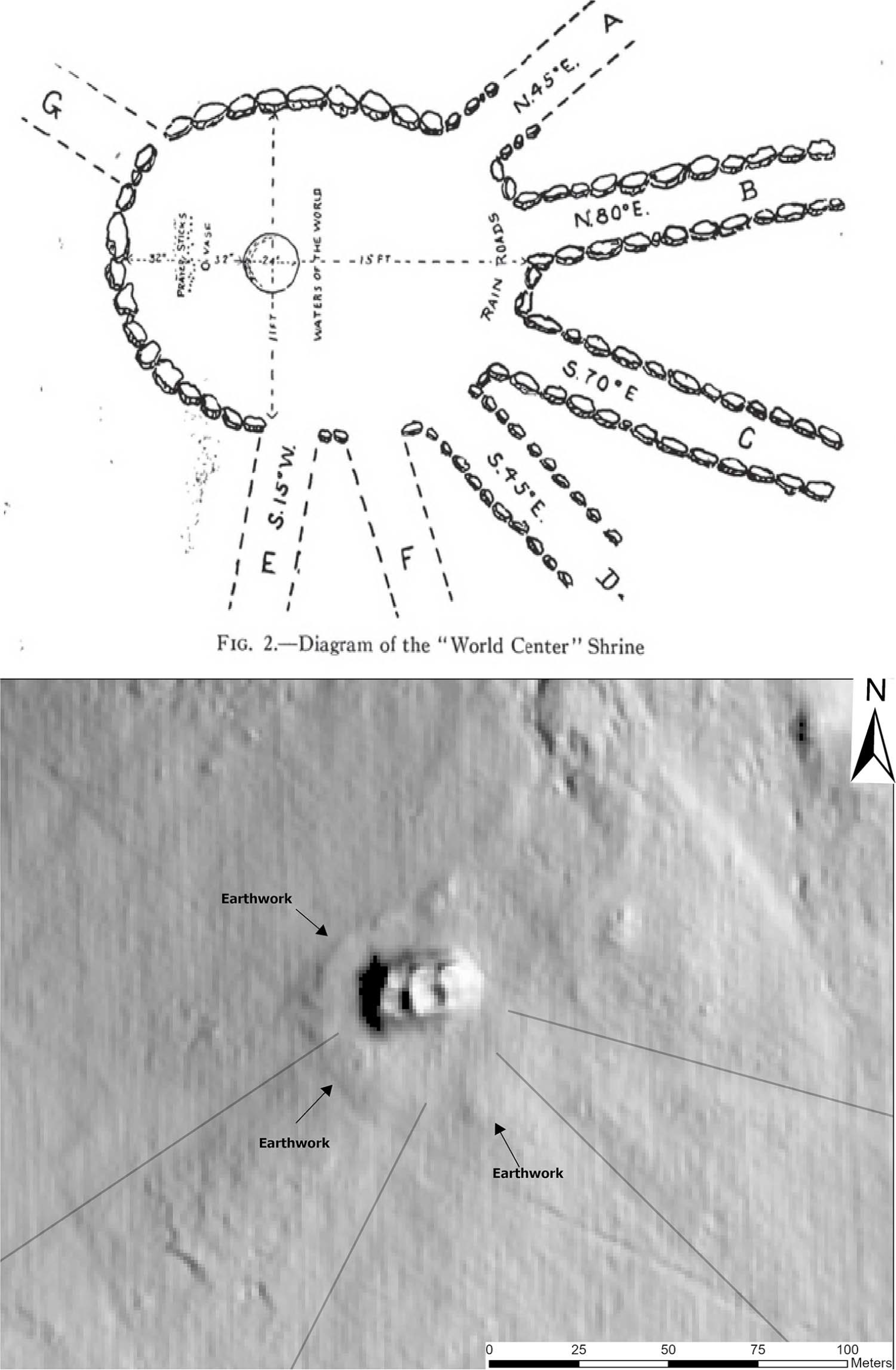
It is striking that the structural organization of Great House landscapes during the Chaco era, including at Kin Nizhoni, finds its closest parallel in the World Quarter Shrines of later Pueblo history (previously noted by Fowles Reference Fowles, Cabana and Clark2011:58). Tewa World Quarter Shrines take the form of low rings of stone, often with gaps in the piled stone from which spiritual pathways (sometimes physically constructed as stone-lined channels) emanate (Duwe Reference Duwe2020; Fowles Reference Fowles, Cabana and Clark2011; Ortman Reference Ortman2012). They are typically placed on top of a local prominence with good views to horizon landforms and physically separated from villages. Tewa people today refer to shrines as a nansipu, or “earth navels.” The center of the World Quarter Shrine is the place where the blessings of rain-bearing clouds gather before moving out toward different villages along “rain roads” (Ortman Reference Ortman, Mark and James2008). Chacoan Great Houses, in turn, were frequently located atop high points (Dungan et al. Reference Dungan, Devin, Déderix, Mills and Safi2018), and the nazha earthworks that surround many Great Houses are punctuated by gaps from which constructed roadways emanate toward prominent landforms (Stein and Lekson Reference Stein, Lekson and David1992; Weiner Reference Weiner2023). The nansipu atop Tsikumu Peak, the Tewa sacred mountain of the west, is an especially clear example of the parallel layout between World Quarter Shrines and Chacoan Great House landscapes (Figure 10; Douglass Reference Douglass and Frank1917). A key difference between Great Houses and World Quarter Shrines, however, is the general understatedness of the latter (Swentzell Reference Swentzell, Baker and Price1997). This transformation of conceptual space seems to parallel the overall pattern of simplification and abstraction in architectural expressions of Pueblo cosmovision evidenced by the two sites—a monumental masonry structure (and likely dwelling place of elite members of the community) becomes a simple stone circle with a void at the center, separated from all community dwellings.
Douglass’s (Reference Douglass and Frank1917:Figure 2) diagram of the Tsikumu nansipu shown in comparison to lidar image of the nazha earthworks and roadways at Kin Nizhoni. Chaco-era roadways are marked by thin lines. Figure by Robert S. Weiner.

The evidence bought together here suggests that World Quarter Shrines “inherited” principles formerly expressed through Chacoan Great Houses. If we continue with the idea of an overall movement toward more subtle materialization in Pueblo ritual landscapes, the structure and meaning of World Quarter Shrines may be informative for understanding the purpose of Chaco-era Great Houses such as Kin Nizhoni. Tewa nansipu are conduits for funneling spiritual blessings in the form of precipitation and moisture to the people. These blessings are conceived as ancestral rain beings who circulate landscapes through networks of nansipus (Swentzell Reference Swentzell, Markovich, Preiser and Fred1990). In the Chaco era, the social structural equivalent of the World Quarter Shrine—the Great House ringed by nazha—was positioned centrally within a community. Furthermore, the regional center of Chaco Canyon replicates this structural pattern at a larger scale: a cluster of Great Houses enclosed within a boundary (the canyon walls of Chaco) with regional-scale roadways emanating outward toward the larger world of Great House communities.
The comparison of Great House landscapes and World Quarter Shrines suggests an inverse (or otherwise distinct) concept of the directionality of blessing between Chacoan and later Puebloan societies. Elite individuals who dwelled in monumental structures in the centers of Chacoan communities and circulated via roads may have fulfilled the same purpose as post-Chacoan ancestral rain beings, who dwell around the perimeter of communities and circulate through the nansipus. In other words, Chacoan religious elites may have been understood as the direct source of rain and blessings that flowed from Chaco (and other Great Houses) throughout the Chaco World. Such an understanding accords with Pueblo oral histories that describe the people living alongside kachinas (rain beings) at White House, a toponym widely recognized as referencing Chaco Canyon (Lekson and Cameron Reference Lekson and Cameron1995; Ortiz Reference Ortiz, Peck, Lekson, Stein and Ortiz1994; Stirling Reference Stirling1942), as well as Diné oral traditions that describe the ruler of Chaco exerting control over rainfall (Begay Reference Begay and Noble2004:56; O’Bryan Reference O’Bryan1956:50).
In summary, we have presented documentation of two ancestral sites in the greater Pueblo World—Kin Nizhoni and Wiyo’owingeh—with emphasis on how the built environment at each site articulates with its associated community and broader cultural landscape. Our findings suggest that key principles of alignments toward sacred landforms and duality were manifested through architecture at both sites. Such principles, however, were expressed in less overtly marked forms at Wiyo’owingeh, suggesting a movement toward more subtle architectural expressions of cosmology between the Chaco era and later Pueblo history. The centuries between the occupation of Kin Nizhoni and Wiyo’owingeh also saw significant shifts in Pueblo social organization from kin-structured communities centered on elite dwellings to aggregated villages with few marked status differences and more pronounced non-kin-based organizations such as moieties (Fowles Reference Fowles and Timothy2012; Ortman Reference Ortman2012), a shift evident in the settlement patterns of the two sites we have examined. Furthermore, we have argued that the constructed element of post-Chacoan Pueblo ritual environments showing the most continuity with Chaco-era landscapes is the World Quarter Shrine. Extrapolating back from World Quarter Shrines to Chacoan Great Houses, we have raised the possibility that elite individuals dwelling in Great Houses were understood as the direct bringers of rain and other blessings in Chacoan society. Our analysis shows that cultural landscape studies provide a useful method for tracing the transformations in Pueblo society between the Chaco era and the present. Importantly, our comparison suggests that it is the structural roles of constructed features, more so than their objective properties, that reveal continuities and changes in cosmological systems over time.
Acknowledgments
The fieldwork at Kin Nizhoni was carried out under Bureau of Land Management Rio Puerco Field Office permit number 344–2920–20–A. We thank Kurt Anschuetz, Cathy Cameron, Sev Fowles, Rich Friedman, Steve Lekson, and John Stein for conversations over many years that contributed to the ideas in this article. We also thank Sev and three additional anonymous reviewers for many helpful comments on an earlier draft.
Funding Statement
This work was supported by the National Science Foundation Graduate Research Fellowship Program (DGE 1650115), the School for Advanced Research 2022–2023 Paloheimo Foundation Fellowship, and the American Philosophical Society Lewis and Clark Fund (2020).
Data Availability Statement
The lidar data used for mapping both sites is available via the US Geological Survey’s online National Map Data Downloader. Original site records for Kin Nizhoni are on file at the Bureau of Land Management Rio Puerco Field Office in Albuquerque, New Mexico, and the Laboratory of Anthropology in Santa Fe, New Mexico.
Competing Interests
The authors declare none.

 Open access