


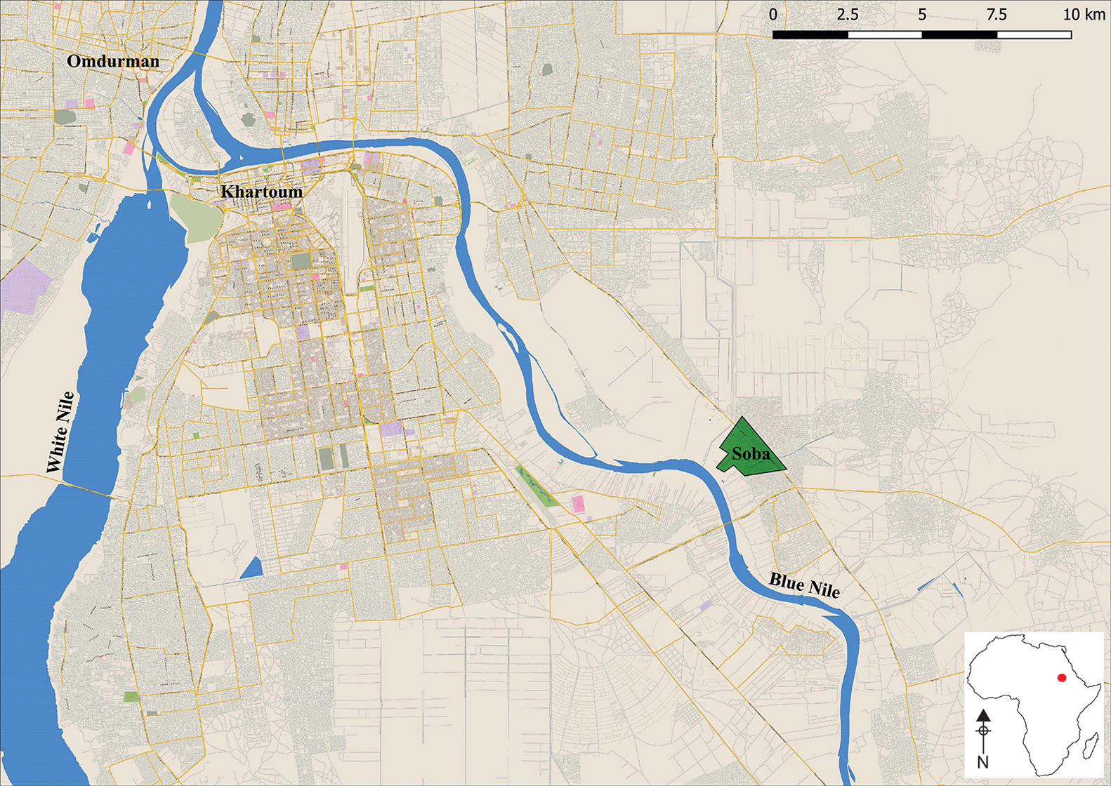
Soba was the capital of the medieval Kingdom of Alwa (c. fifth/sixth to early sixteenth centuries AD). It was described by a tenth-century traveller as a large city on the banks of the Blue Nile, with churches, monasteries, fine houses, beautiful gardens and a district inhabited by Muslims (Vantini Reference Vantini1975: 613) (Figure 1). Alwa was one of three Nubian kingdoms in the Middle Nile region, together with Nobadia—with its capital in Faras (bordering Egypt and approximately 800km north of Soba)—and Makuria, with its metropolis at Dongola, located equidistant between Faras and Soba. Unlike the other Nubian centres, the capital of Alwa was not fortified (Welsby Reference Welsby2002: 120).
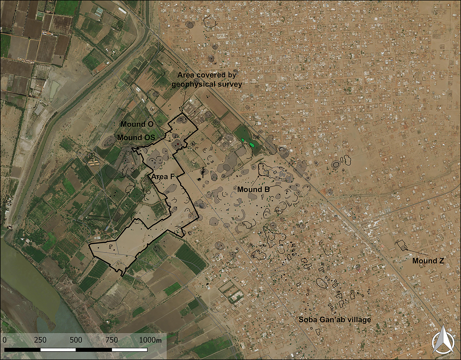
Conquered in 1504 by the first ruler of Sennar, Soba was subsequently abandoned. The history of the city was preserved in oral histories and only written down in the eighteenth and nineteenth centuries. The other Nubian capitals also declined in importance in the medieval period, but remained inhabited after the kingdoms disintegrated. Between the sixteenth and nineteenth centuries, Soba fell into ruin, and from the 1840s, became an area for red-brick extraction, supplying the development of nearby Khartoum (Lepsius Reference Lepsius1853: 162–63, Reference Lepsius1913: 347). Consequently, the surface of the site is today marked by numerous mounds (Figure 2) covered with red-brick debris and gravel. The layout of the medieval street network and the location of squares and buildings plans are identifiable neither from the ground level nor from the air.
Map of the region in 2020. The green polygon marks the archaeological zone at Soba (prepared by M. Drzewiecki; background: Wikimedia open street map).
Soba's mounds and areas mentioned in the text (prepared by M. Drzewiecki; background: Bing Aerial view).
Archaeological research conducted throughout the twentieth century uncovered the remains of five churches, an ecclesiastical complex, a pagan temple, fragments of fine buildings, numerous examples of timber architecture and a few small cemeteries (Shinnie Reference Shinnie1961; Welsby & Daniels Reference Welsby and Daniels1991; Welsby Reference Welsby1998). Despite these results, at the end of the twentieth century, Welsby (Reference Welsby1998: 21) concluded that only around 1 per cent of the city had been studied in detail. This hints at the size of Soba, which is one of the largest archaeological sites in Sudan, covering approximately 275ha, and is comparable in size to medieval urban hubs on the continent and beyond. The spatial organisation of the city cannot be seen today, and is difficult to investigate.
New project
A new project, launched in 2019, undertook geophysical prospection of the accessible areas of the site (approximately 53ha). The survey was supplemented with targeted excavations to investigate magnetic anomalies. Over the last 20 years, the agglomeration of Khartoum has begun to encroach on a substantial area of medieval Soba, making excavation impossible. An anthropological aspect of the project aims to engage local communities in the research and preservation of surviving Soba heritage in these areas. The first full season of fieldwork was conducted in 2019–2020 and yielded numerous insights into the spatial organisation of the city and its dynamics. This article focuses in detail on discoveries relating to the final centuries of the metropolis.
Oral folklore and the fall of Soba
Stories of ancient artefacts are embedded in daily life in modern Soba and are eagerly shared in casual conversations. The most common opening gambit for such conversations is ‘Ajoba destroyed Soba’ (Arabic: Ajoba al-khrabt Soba), a phrase that relates to a children's tale (Arabic: hujja, meaning ‘wisdom’). The story is a variation of official oral histories and recounts the life of Ajoba, the queen of Soba (alternatively a witch, or an ordinary woman). She had a beautiful daughter named Tayiba, whose hand in marriage was sought by many kings (or noblemen). Ajoba was greedy and deceitful (vengeful, in some versions). She demanded a payment of gold from each suitor, and that each should kill his previous competitor. Many men died and chaos reigned in the country. Ultimately, however, Ajoba's plot was discovered and the surrounding tribes united to attack Soba.
The final years of the city in the archaeological record
The fabled ‘chaos’ that reigned prior to Soba's final conquest is partly attested in the archaeological record. Welsby (Reference Welsby2002: 255) suggested that the twelfth to thirteenth centuries were the final years of Soba's occupation. By the early thirteenth century, two of the fine churches were already in ruins, as indicated by the small finds assemblage and radiocarbon dates (Table 1: samples GU-1688, Q-3215, Q-3216). The nearby tombs of dignitaries were pillaged, while on Mound Z, a group of late graves was recorded (Table 1: sample BM-2883).
Late radiocarbon dates from Soba (calibrated using OxCal v4.4.2 and the IntCal20 atmospheric curve (Bronk Ramsey Reference Bronk Ramsey2020; Reimer et al. Reference Reimer2020)).
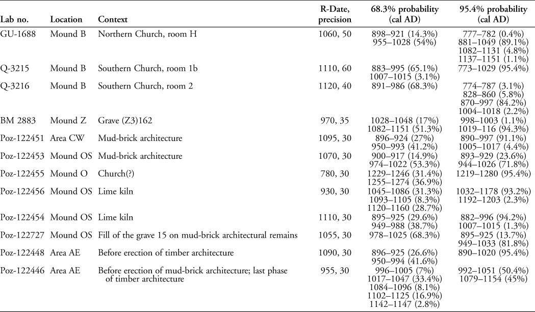
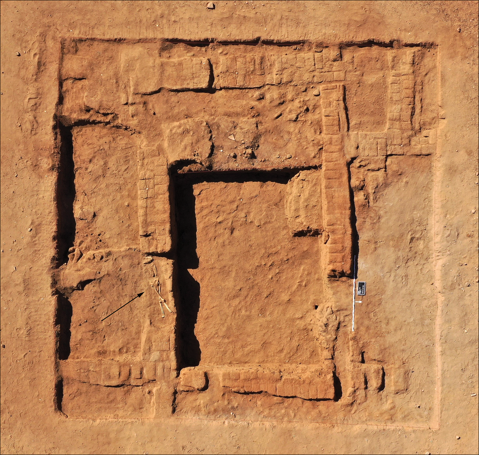
The 2019–2020 fieldwork provided eight additional radiocarbon dates for the final phases of settlement from other parts of the site, where mud-brick and timber architecture was still being used for construction in the later period (Table 1). At Mound OS, archaeological sondages revealed mud-brick walls preserved up to 2m in height (Figure 3). Radiocarbon dates indicate that the buildings and their surroundings were already in ruins by the eleventh century, and the mound was used subsequently as a cemetery. Within the 125m2 excavated to date, 22 graves have been recorded. Burials are diverse in terms of orientation and positioning (similar to some graves on Mound Z). Bodies were interred in simple, shallow pits, and no funerary architecture was detected. Some individuals appear to have been wrapped in shrouds or buried in clothing, as tiny fragments of dark brown, coarsely woven fabric were recorded.
Aerial view of Trench 1/OS. The remains of mud-brick architecture were uncovered just below the surface. The black arrow indicates the location of burial 21, which cuts the top of a wall (photograph by M. Drzewiecki).
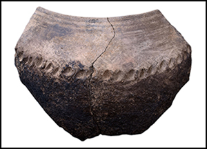
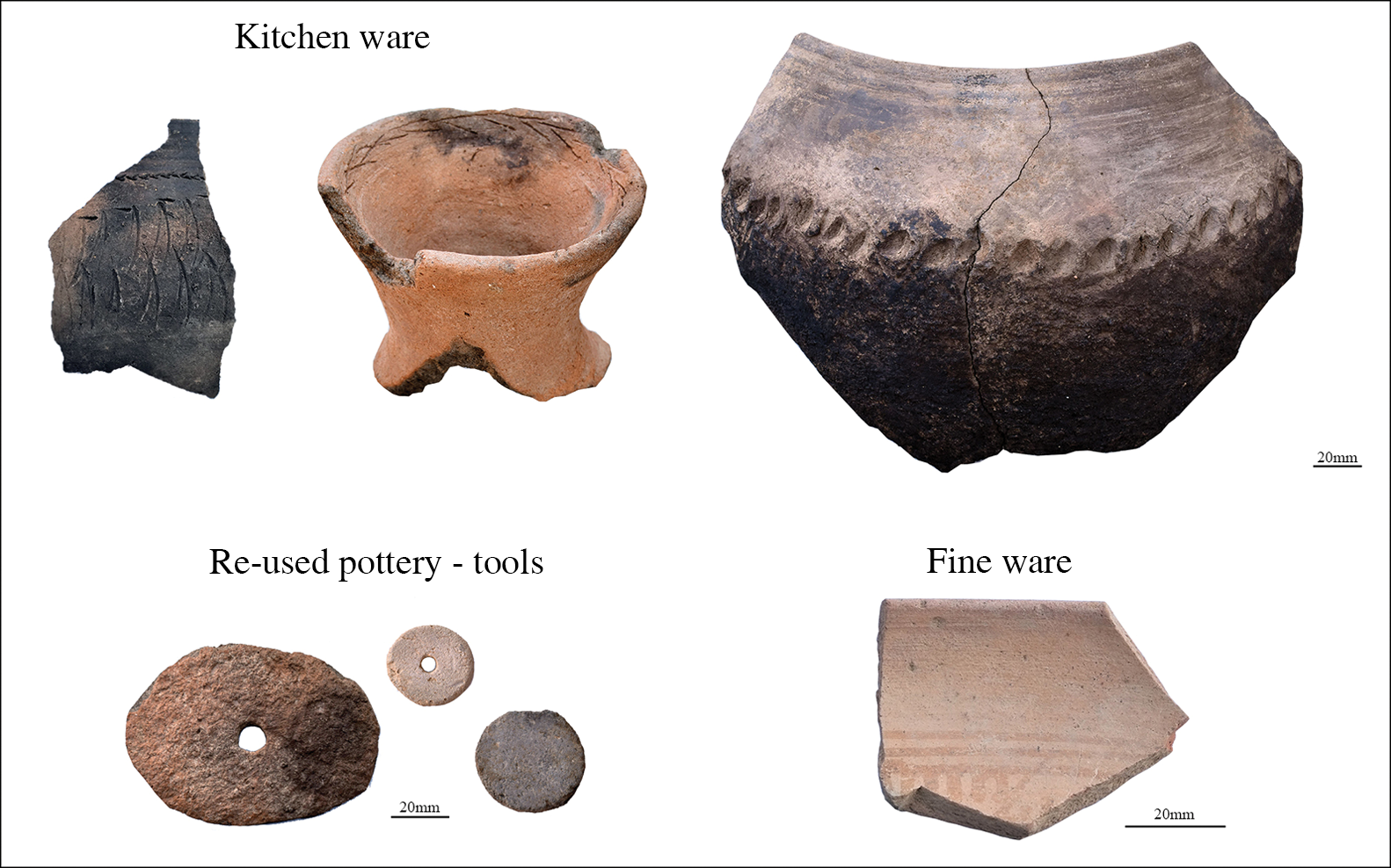
Cemeteries in Soba were often located beside churches. There was a probable church located approximately 60m north of the burials (on Mound O), from which the youngest radiocarbon date from Soba was obtained, indicating that the church was still in use in the thirteenth century. The pottery from Mound O (Trench 1/O) is a homogeneous assemblage (Figure 4). The vessels were similar in terms of execution, style and form throughout the entire occupation period (from eighth or ninth to thirteenth centuries).
Pottery from the excavations on Mound O (prepared by E. Czyżewska-Zalewska).
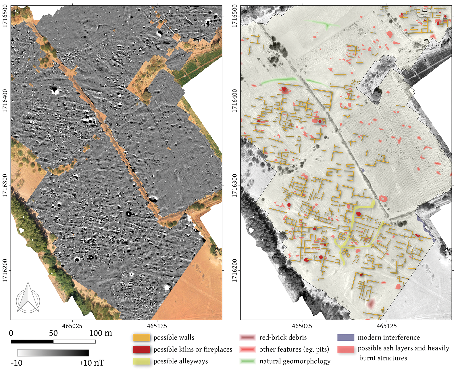
Extensive and late architectural remains were also recorded in Area F (Figure 2). They cover a large area, creating an urban district of at least 3.6ha, featuring densely packed mud-brick houses and an irregular network of streets (Figure 5). The material from the surface indicates that the district was inhabited during the late phase of the city (Welsby & Daniels Reference Welsby and Daniels1991: 30).
Geophysical survey in Area F: magnetic data and interpretation (prepared by R. Ryndziewicz).
Conclusions and perspectives
By the beginning of the thirteenth century, the central administration of Soba may have been weakened. The city probably witnessed an influx of new settlers (as demonstrated by selected graves on Mounds Z and OS). Although Christian communities may still have been living in the city in the thirteenth century, the human remains from the cemetery on Mound OS will be further analysed using isotopic analysis of oxygen (δ18O) and strontium (87Sr/86Sr) to investigate migration patterns and population diversity.
The tale of Ajoba is an example of a legend that holds great potential in uniting the local community and researchers in a common agenda, to preserve what remains of the tangible and intangible heritage of Soba.
Acknowledgements
The host institution for the project is the Polish Centre of Mediterranean Archaeology of the University of Warsaw. The partner institution is the Institute of Archaeology and Ethnology of the Polish Academy of Sciences. We would like to thank the community of Soba and the local authorities for their support.
Funding statement
The project is funded by the Polish National Science Centre (grant UMO-2018/29/B/HS3/02533).



