




The city in view here is Colombo.Footnote 1 Colombo is approached through a thick analysis of various infrastructural projects that were crucially interlinked given the wetland geography in which they unfolded.Footnote 2 A breakwater development project, flood outlets, a fishery harbour and a canal scheme are analysed below. But these intersect with river works, road and railway building and suburban sprawl, which were also about changing uses of terrain. The aim is to move from these seemingly different programmes, which were proposed, budgeted and executed as engineering interventions in a wetland, to an account of how they sit together within landscapes of ecology and human habitation. In other words, digging the earth or rerouting rain water cannot be undertaken in an isolated clinical fashion as colonists imagined they could be.
The ways in which people responded to such programmes show symmetric modes of contest that arose out of material change and congestion at points of new settlement. By congestion, the article refers simply to the increasing concentration of humans and human activity at environmental choke points of urban development. The segmentation of peoples and nature which followed such congestion is a context for the rise of inter-human conflict along lines of class as well as ethnicity and livelihood. Urbanization unfolds in the late modern port city in the Global South partly from lines of infrastructural change. Canals and harbours set the foundation for how a city grows and takes shape. The focus on breakwaters, harbours, canals and other projects allows the micro to be twinned with the macro. Stones and bricks and their ecologies, pathways and labour stand for the city as a whole.
Colombo, at the centre of the Indian Ocean world, is an excellent city from which to analyse the environmental history of the Global South city. It has been multiply engineered even as it has been multiply colonized over a long era.Footnote 3 The relation between these two modes of layering, namely repeated engineering and repeated colonization, is central to explaining why infrastructure becomes a site where so many contests unfolded. This is an urban environmental history which is in conversation with social history as well as the history of colonialism. But it approaches these broader questions of the natural, the human and the political, from infrastructural interventions in particular neighbourhoods that were inserted into a wetland. To work at this juncture of historiographies is to return to some of the most fundamental questions of Sri Lankan studies about ethnic differentiation, labour and imperialism, from a very different footing.Footnote 4 This does not over-ride established routes into these topics. These established routes include analysis for instance of legislative representation, religious and literary discourses, the nature of ethnic contest and violence in public places, or the life of indenture within interior plantations. Rather, this article adds a different angle.Footnote 5
The origin of Colombo is mired in many myths, and it would be unwise to try to parse these. Regardless of what stood here prior to Muslim settlement, among Europeans it was the Portuguese who first built a trading post in 1518.Footnote 6 The city then became a bastion of Dutch (1656–1796) and British (1796–1948) colonization. Right through the European history of Colombo, changes to terrain were undertaken around lakes, canals and other modes of urban development to make the city habitable. This article focuses on the late modern era after 1870 and into World War I, but also with some exploration of the later twentieth century. In these decades, the city became one of the world’s leading ports indicating why it became congested.Footnote 7 The harbour was developed north of today’s city and at a headland that juts into the ocean as a slip of land. Colombo does not boast a large natural harbour. Rather, the reasons why this site was chosen by multiple colonial regimes include its proximity to the Kelani Ganga (Kelani River) just above the city and its strategic placement on Indian Ocean trading and migration routes. This locale also became a focal point of development because of the kingdom of Kotte in the hinterland of this coastal strip which flourished in the sixteenth century.
This article concentrates mainly on the area from the mouth of the Kelani River to Galle Face Green, the public lawn, which is still at the heart of the city. Its last section goes south to the district of Wellawatte, which was a frontier of the city in the later nineteenth century. This entire landscape still shows the signs of historic urbanization. For instance, Galle Face Green was the site of one of the world’s most sustained post-pandemic protests against economic inequality and authoritarianism in 2022. Yet, this ‘aragalaya’ may be interpreted, as I have done in collaboration with Samal Hemachandra and elsewhere, in light of how this artificially flattened lawn served as a site of conflict in years gone by.Footnote 8 The harbour development by the British, discussed below, has a parallel in what is in progress right now in Colombo, in the same general area, and once again links history to the contemporary moment. A $15 billion dollar Port City Development Project, part of the Belt and Road Initiative, is in the works and will build a new footprint of land in the sea.Footnote 9 Though the article is a close study of specific infrastructural projects and moments of colonialism and contest, the resonances are still alive today.
This history of Colombo appears at a moment when there is a new wave of writing on the environmental history and political ecology of port cities in India.Footnote 10 This marks the urgency of the topic, given the virulent development along this vast and intricate coastline and the geopolitical competition for supremacy over Indian Ocean sea-lanes. Sri Lanka lies at the fringes of this scholarship, a point the island’s historians have often made in responding to an India-focused historiography. Yet, as Devika Shankar’s work on the ‘failed’ port of Tuticorin excellently demonstrates, port development and planning in South India and Sri Lanka could impact each other, especially given the pearl fisheries or the plantation systems on the island that relied on South India connections.Footnote 11 Nikhil Anand and Lalitha Kamath describe the ‘eviscerating’ effects of port development on fishing communities, especially in Mumbai, through a programme of declaring the seas empty and ‘aqua nullius’. This closely relates to how fishers of various community heritages were dislodged from the Colombo coastline. These words from Anand and Kamath apply directly to the material below: ‘The urbanization of the sea is materialized through infrastructure and reveals the violence of evisceration.’Footnote 12 In response to this statement, one might add that this ‘evisceration’ also affects waterways that link hinterland to coast and that there is an essential entanglement between coast and land reorganization around canals, river works and breakwaters.
The specific intervention of this article in South Asian scholarship lies in its attempt to think through a range of nested and micro level infrastructural interventions: breakwaters, a fishery harbour, a flood outlet and canal. This is aligned with what Maan Barua terms ‘infrastructure in minor key’.Footnote 13 It is a different way to focus attention when placed next to scholarship on the port as a whole. The specificity of Colombo lies in its wetland and island geography, which means various types of infrastructure need to be approached together. Indeed, the island itself is a distinct space for port making, given the way it was cast in pre-colonial as well as colonial times as a transit site, how it was bounded around an attempt at ‘islanding’ and how there were so many historic harbours across the island facing various directions.Footnote 14 More broadly, it is possible to locate Colombo’s story next to those of Aden or Singapore, which have also been attracting more attention of late, especially for the period after the opening of the Suez Canal. Dredging work took place at all three ports to create a seabed which was aligned with the depth of the Suez Canal.Footnote 15 The historiographical routes from Colombo do not only lead to India. In the context of the current special issue, they may usefully also run to Lagos or Iquitos. The tragedy of port making in the late modern period, given its alliance with global capitalism, lies in the way imperial ports were symmetrically modelled so widely across geographies, while nevertheless having to come to terms with specificities in particular ecologies such as the wetlands of Western Sri Lanka.
It is worth also introducing the human dramatis personae for the history that follows. The number of petitions that arose in the context of infrastructural change and which are extant in the archive is surprising, but they are an indicator of how everyday changes to land and water affect people’s habits of life and generate friction with the state. These petitions were often multiply signed by fishermen, merchants or by other groups such as religious communities. Given the nature of the infrastructure, timber merchants, who passed wood over water and downstream, appear in these bundles of paperwork. Also referred to from time to time in the archives around waterways are lands covered by small gardens or plantations of particular crops, which highlight how waterways were crucial to the transport of natural commodities.
People who were socially ascendant, transforming themselves from ‘nobodies to somebodies’ in the context of later modern Sri Lanka, to use Sri Lankan historian Kumari Jayawardena’s felicitous phrase, included those at the head of both fishing communities and the timber trade, among other petty commercial activities. Jayawardena’s work attended to how their caste status, for instance the critical caste category of karava which indicated a fisherperson, could be expanded to signify the newly wealthy. This category was transformed within a newly forged class hierarchy that was predicated on access to opportunities in colonial times.Footnote 16 Beyond the petitions arising from fishermen and merchants are the indigenous elites who held the colonial titles of chieftaincy, namely ‘Mudliyar’. These titles indicated that they benefited from colonial patronage and that they served as intermediaries of sorts, for instance for the maintenance of law or for the collection of rents. John F. Perera was Fisher Mudliyar and is an ever-present correspondent below. He took up his post, first as Customs Mudliyar before becoming responsible for fishing communities. He was first appointed in 1871 and apparently belonged to a ‘distinguished Salagama family’.Footnote 17 Salagama is a reference to the caste community that included cinnamon peelers.
Beyond the voices of subalterns and elites who were island inhabitants are those of colonial officers. Government agents, public works officers and even policemen and legal experts, all of whom were stationed in Ceylon, became involved in the tussles around the improvement of the city. Also, relevant here and in a separate category are the travelling engineers who forged a career in engineering projects in various colonial locales. One of these, John Coode, is also ever present in the sources.Footnote 18 Most of the dominant archival voices across all these groups are men. However, at the beach where fish was cleaned, or at the mill where cloth was produced, women were as crucial to this waterside story. They too could participate in resistance to the hydrological transformation while being typecast in gendered ways. A vocabulary of ethnicity was also in operation, quite revealingly aligned with types of boats. The phrase ‘catamaran men’ could refer to so-called Tamil communities, who were cast as distinct to the self-identified ethnic majority of the Sinhalese.Footnote 19
Today, in Colombo’s Port Authority Maritime Museum, which was devastated by the 2004 tsunami and re-established with money from the Dutch, there is a celebration of the origins of the port, including attention to the Portuguese fort, the Dutch fort and the British harbour, both before and after breakwater building. Yet, in the corner is a panorama showing a beach-scene of this coastline (Figure 1). It is a throng of people taking up a sequence of roles. Some are out at sea. Others are hauling nets. Yet others are in conversation. There are women carrying loads on their heads. It usefully evokes the social and environmental landscape that is interrogated in this article, even if it is a mythical rendition. Infrastructure disrupted this integrated context of humans, fish, sea and beach, among other elements. While differences of caste and kin and status certainly had pre-colonial origins, what is necessary to remember is that this was a hugely mobile context of gathering. The south-west coast even included trade and contact with the wider Indian Ocean world and with mainland South Asia in particular. It also included many forms of itinerant life and community formation across water and land. Recent anthropological work on Sri Lanka by Rapti Siriwardane-de Zoysa attends to the unique modes of co-operation and solidarity among fisherfolk elsewhere in the island, as ‘lateral, a-sociative and hierarchical’: this work is useful in contextualizing the relations that were restructured around port infrastructure.Footnote 20 Also worth using as a reference frame is Tamara Fernando’s widely discussed recent article in environmental history on the subject of the long-standing Ceylon pearl fishery, which points to how this itinerance had a multi-species character.Footnote 21
Panorama at Port Authority’s Maritime Museum, Colombo. Author’s photograph, July 2023.

This article is part of a wider project on the long history of Colombo.Footnote 22 It might be placed in relation to what is being called an ‘infrastructural turn’ in the humanities.Footnote 23 Among historians, this attention to infrastructure has led to the interrogation of material and technological processes through which connection and mobility are created. Focusing on infrastructure is a way of grounding broader structures, such as empire or capitalism, in oftentimes taken for granted or obscured technical interventions. It allows the mundane and everyday to be related to world making. In one recent explanation: ‘infrastructures create the space for racial, social, and economic inequalities to grow and becoming enduring’.Footnote 24 In Sri Lanka today, highway making, bridge building or harbour making carries on at great pace. These are a set of publicly addressed projects through which global superpowers as well as local political elites can play and perform, but the obsolescence of this infrastructure can sometimes follow. The critical placement of this article in this broader field lies in its interrogation of ecologies and environments and forms of labour and resistance, both urgent topics in world history writing given present political contexts.
The discussion now begins with breakwaters and then widens to the environmental issues around flooding as well as the human settlement opened by harbour development, before turning to the south of the city and to a flood outlet or canal at Wellawatte.
A broken sea and its makings
A breakwater seems now an unusual feature of a city to feature in a tourist guidebook. In 1877, Colombo’s first breakwater, then under construction, appeared in such a guidebook for the English-speaking traveller who called at this burgeoning port city at the centre of the Indian Ocean world.
It noted that the breakwater could be ‘reached through the road descending from the Esplanade to the water gate’.Footnote 25 The ‘Esplanade’ was a reference to the walkway by the sea, at Galle Face Green. Today, people still walk by the sea at Galle Face Green. The same guidebook published by the Ceylon Times Press continued: ‘Two enormous machines called Titans, worked by steam power, are employed during the five months of the year, say from October to May.’ Their task was to lay blocks from a ‘bed of broken rubble stone’. And the prospect in view was set out: ‘By the end of the northeast monsoon in May, 1878, it is expected that a thousand feet of the breakwater seawall will be laid.’ Even now, people watch machines at work at the sea and at Galle Face Green, creating new infrastructure and land. This time it is the turn of China rather than Britain, as the port is being developed as part of the Belt and Road Initiative.
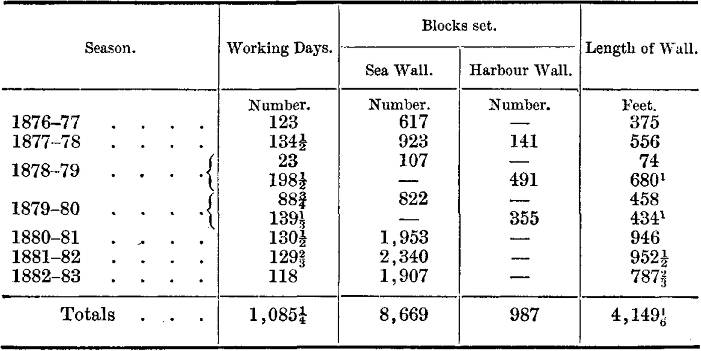
These breakwaters required gruelling human labour to construct by hand. This summary of the working days that went into the creation of the first breakwater, the so-called south-west arm, serve as a reminder of this fact lest the tourist gaping is taken for granted (Figure 2).
From J. Kyle, ‘Colombo harbour works, Ceylon’, Minutes of the Proceedings of the Institution of Civil Engineering, 87 (1887), 84.

This first phase of the project generated a sheltered area for the harbour of about 502 acres and cost £705,000 over 10 years.Footnote 26 Shallow water was also dredged to make the water deep enough to serve as a harbour. It was estimated that 25 steamers could now moor in depths of 26 to 40 feet of water, while further vessels could use shallower water.Footnote 27 The construction involved granite being quarried about 11 miles away and being sent by train to the site of what became the south-west breakwater. ‘The minimum output’ at the quarry was ‘100 tons a day’. ‘The top rock was bored from 12 to 18 feet deep by 2½ inch drills, and blasted down in masses by pebble-grain powder.’Footnote 28 The blasting operations were conducted by ‘free labour’, while the loading of the granite on to wagons for the train journey was conducted by ‘convicts’. The use of convicts for this stonework matched their use elsewhere in Colombo’s breakwater projects and made it possible for the infrastructural work to proceed at a lower cost.
A reef of ‘dangerous rocks’ had to be enclosed in the first stage of construction. ‘Tipping of rubble’, together with ‘earth filling’, set the foundation or the ‘root work’, for the breakwater, and then blocks of stone were manufactured and laid by convict labour.Footnote 29 The regime of work conducted by the labourers was described like this:
During the monsoon season, the prisoners worked eight hours a day; in the setting season, a twelve-hour system was adopted. In the slack season, one hundred and sixty-six prisoners manufactured six blocks a day; whilst during the twelve-hour system, three hundred and nine prisoners made twelve blocks a day, without increasing the cost per cubic yard. A charge of 37½ cents per day of eight hours was made for each prisoner employed, which included the guards and police in charge of the gangs.Footnote 30
The fact that much of this work was underwater is worth underscoring, especially since Tamil divers were so ridiculed and sent after coins tossed in the water close to the completed breakwater.Footnote 31 The diving was no game. Indeed, the diver was effectively another kind of machine.
Often, environmental conditions interfered with this programme of artificial development. The Titan, the machine mentioned in the guidebook, could not be left out at the construction site in the stormy season. In April 1878, ‘an unusually heavy south-west monsoon’ swept away a 14-ton block and damaged the sea wall. Large quantities of sand were washed on to the foundations of the breakwater by the south-west monsoon in 1879.Footnote 32 These had to be removed by divers. The interference of nature was especially evident in the fact that close observations had to be kept of wave heights, wave periods and winds during the monsoon. It was supposed at first that 9 feet was the greatest height of waves at Colombo, but subsequent measurements determined that where the breakwater was being built waves rose to 12 feet and 15 feet. In 1891, in the middle of breakwater construction, there was concern about sewage being deposited into the harbour. Was the breakwater affecting the circulation of seawater, or currents, and preventing the washing away of the effluent? Also of concern was how the completed parts of the project had already led to coastal erosion.Footnote 33
These administrative and technical sources are worth citing in detail because they are not usually discussed by historians. Yet, they reveal the nature of the work that makes arriving at and departing from a city possible and how that work required bodies, earth, water and machines to be melded together and continuously recalibrated. Yet, there is another angle from which these technical texts, which follow a start to finish logic from the laying of the first stone by the prince of Wales in 1875 to the completion of the breakwaters, should be further contextualized. Breakwater construction was part of a wider programme of hydrological management in the later nineteenth century. Focusing too clinically on the breakwater projects allows this fundamental transformation of land, water and habitation, and the ecologies in which it proceeded, to be lost from view.
A flooded city and its discontents
The first place to look for a wider landscape in which to place the breakwaters’ management of the sea is to attend to how flooding was a recurrent feature of city life in late nineteenth-century Colombo. This flooding also had to be managed in the very period that breakwaters were being built.
Flooding was said to be ‘annual’ or often ‘bi-annual’.Footnote 34 Some crucial years worth noting in the era in focus up to World War I are 1837, the ‘great flood of 1872’, and flooding in 1878, 1883, 1891, 1904, 1906 and 1913.Footnote 35 As one government agent put it in 1877, floods occurred when the Kelani River ‘inundate[d] periodically a large portion of the north town and suburbs’. His correspondence was part of a new bid to plan a more elaborate set of flood outlets and canals to drain excess water.Footnote 36 The Kelani River was said to require five times its capacity in the later nineteenth century in order to carry off the amount of rain that fell. But even a focus on this river alone is insufficient as a context to understand the dynamics of flooding in this terrain.Footnote 37 A greater span of coast along these lowlands around the city, both to the north and the south, was liable to flooding from other waterways besides the Kelani (Figure 3).
‘Plan showing flooded area in Colombo South’, 1923? The area marked in red is above flood level and that marked in green is in danger of flooding. The canal is the second outlet marked as ‘Sea Outlet’. With permission from the Sri Lanka National Archives, Colombo.

As an officer involved with public works put it in the same year, ‘in heavy floods all the rivers from Chilaw on the north to Bentota to the south [with Colombo in between] overflow their banks, and the waters unite and become one vast flood submerging the whole of this low-country’.Footnote 38 Within Colombo, ‘houses are frequently submerged, and in many instances swept away’ as a result of this pattern of flooding. ‘[C]attle, goats, pigs, and poultry have also been destroyed, and the crops suffer to a serious extent.’ There was then an increase in the price of food. People were unable to travel into the city for work. Bridges could be destroyed or made impassable. The ‘destitution of the people from want of employment’, in the phrase of this colonial officer, render the inhabitants of this region, ‘easy victims to those diseases which invariably originate’ as floods subside.Footnote 39
John Coode, the colonial engineer introduced earlier, was involved with the breakwater project in Colombo as well as numerous other British imperial harbour schemes stretching from New Zealand and Australia to South Africa. He was consulted on flood outlets and bridges to deal with this perennial problem.Footnote 40 In other words, the same broad class of technical expertise involved with breakwater construction appeared in the discussion of flood outlets. This is another type of interconnection across these different infrastructures. In the case of flood outlets, this technical expertise ran across: measurements of the heights of river water and levels of the ground; the study of the inter-relation of lakes and waterbodies including for instance the Beira Lake close to Galle Face Green, Bolgoda Lake, Kotte Lake (now Diyawanna Lake), Panadura Estuary and the Hamilton Canal built in the earlier nineteenth century and also other rivers such as the Kalu to the further south of the city; and prospecting changes to earth and sand to make channels for water that could run to the sea.Footnote 41 This means that the breakwater project was not only part of a global programme of imperial harbour making, it is also related to a whole series of intricate concerns around the relation of water and ground in lakes, canals, rivers and estuaries.
Mudliyar D.C.H. Bandaranaike of Siyane Korale wrote to the government agent of the Western Province in 1872:
the cause of the late floods was owing to the extraordinary and sudden breaking of the rainy clouds in the upper part of the Kelani river, on the hills, and the obstruction of the free passage of the water by railway embankments on the fields …The floods first reached the villages [in his district or Korale] on the 8th, and continued to rise from the 9th.Footnote 42
These indigenous elites, from the hinterland of the Western Province where Colombo lay, were co-opted into these schemes of infrastructural improvement and environmental measurement. Their letters, copied into colonial flood reportage, are replete with dates, times and measurements. Take for instance another missive from a Mudliyar whose name is reported as Jno. Em. Perera, who presided over Hewagam Korale. He too was writing in the context of the flood of 1872:
The height to which the water rose in different parts of my district is as follows, viz: At Avisawella, on the high road, it was about eight feet deep; at Hingurala, the depth was nearly the same; at Hanwella, on the road, it was about fifteen feet, at Jaltara, about fifteen feet deep…The water began to retire on the 13th ultimo…The cause of the sudden and unprecedented rise of the flood is attributed to the railway embankment. Another cause is said to be the obstruction or rather the closing up of the sluice gates, which formerly existed about the Fort of Colombo.Footnote 43
Yet, there is a tragic immediacy to the Mudliyars’ updates and information, which is lacking in the sanitized prose of colonial engineers. Take this letter from the Hewagam Korale in 1878, at another moment of extreme flooding. It is from Mudliyar J.E. Peiris:
The devastation done is very great: several houses have been levelled to the ground; and the walls of the greater number have been washed off, leaving only the bare sticks, the minor cultivations such as yams, beans &c…have been destroyed. Water is still on the increase. Some coolies who were going down to Colombo in a boat were carried away by the current, and a man is said to have been drowned, but the corpse has not been found as yet.Footnote 44
It was not only Mudliyars who took to pen in the context of flooding. Landowners and various residents wrote petitions as well. In 1872, a petition arrived from ‘inhabitants of Kotte and nine adjoining villages’. They also took it upon themselves to recommend a course of action to alleviate the flooding:
[A] proper and effectual route for a canal, Your Excellency’s memorialist beg to point out the one, which they and their ancestors then pointed out…The route takes its course from the vicinity of the Kotte bridge, where waters rush in from all directions…Thence through the Cinnamon gardens to the sea at Kollupitiya, between the second and third mile-posts on the Galle Road.Footnote 45
What petitions like this represent is that in a site where the land was well known and cultivated, and where water inundation caused direct distress, solutions were also proposed by resident communities, both elite and non-elite. Worth noting is that the Kotte petition was signed by no fewer than 540 individuals. It was drawn up by Edward F. Perera. After the 1878 inundation it was reported that a ‘Mr Odris De Fonseka, Muhandiram, living at Pohadaramulla’ had offered to make a small flood outlet, to ‘incur the cost of feeding laborers’, if the colonial state provided him the requisite ‘professional superintendence’.Footnote 46 This is a useful reminder that tank and reservoir upkeep was a long-standing feature of village life as well as monarchic life in Sri Lanka and that the new scheme of flood outlets fitted into this history.Footnote 47 The novelty of colonial hydrological management should not be over exaggerated. This after all was partly how the colonial imagination ran.
The connection between development on one side of the beach, where the breakwater lay, and on the other side at the hinterland of the coast, where flooding occurred, was fundamentally material. This is a necessary point to make in countering the colonialist programming of distinct projects and phases of implementation, a feature of engineering and urban planning then as it is today. A city’s development on land had consequences in the aquatic environment and vice versa. As the colonists changed the lowland of the city through urbanization and infrastructure of various kinds, including breakwaters as well as roads and railways, the fluid dynamics of water in this wetland shifted. The signs of this are very evident in correspondence connected to the mouth of the Kelani to the north of the city. Here too the expert voice of Coode resonates. He asserted that the ‘action of the heavy seas’ on the western coast of the island caused a sandbar to form at the mouth of the river. Such a phenomenon was apparent in all rivers on this coastline. The creation of artificial outlets at the mouth of the river would not ease the problem; rather, the reef had to be blasted to sort the problem out.Footnote 48 Despite this advice from on high, the work at the mouth of the river was entrusted to another local operative, John F. Perera, introduced at the start of the article, who also held the title of Mudliyar and was in charge of fishing communities.
Perera’s many letters on the subject paraded his homegrown and on-the-ground expertise which were contrasted to that of the state’s Public Works Department. Perera wished initially to widen ‘the natural mouth’ of the river. The phrase ‘mouth of the river’ was a way of referring in the period to the area depicted in the plan, which was the major sea outlet of the Kelani River (Figure 4). In 1891, he first reported that he had completed the widening of the mouth ‘just in time’ for the floods and that the water subsided ‘sooner than what it would otherwise have been’.Footnote 49 A separate outlet far from the river mouth would have been ‘impractical’. By the next year, however, this opening ‘near the mouth’ had ‘closed.’ By 1895, he wrote:
‘Plan of the mouth of Kelani Ganga [River]’, lot 33/2294. With permission from the Sri Lanka National Archives, Colombo.

I have widened the mouth of the Kelani Ganga [River]…In addition to the widening of the river mouth, I caused the Mutwal sandbar to be cut right across at Lansiwatte and altho’ I got this outlet opened 3 times it was quite impossible to force the flow of the river through this new outlet as long as the natural mouth of the river was in so wide and in such good working order and in close proximity.Footnote 50
In the aftermath of this work, a controversy unfolded about whether Perera had overcharged the state for this work at the river mouth.Footnote 51 In the following year, in 1896, his inspections highlighted the obstruction caused by 26 cargo boats moored in the river, and how this mooring obstructed the movement of sand and silt.Footnote 52
As a general context to the story, what is clear is that the area around the river mouth was becoming congested not only by too much water, but also by commercial activity, for instance by traders and merchants of timber, who competed with fishermen for river access. Timber was a crucial resource that was being transported on water, sometimes floated down from the hills to the coast to support urban expansion and other uses. This congestion at the river’s mouth was the result of colonial urbanization.
A group of timber merchants, ‘inhabitants of Modera’, petitioned the state in late 1901 or early 1902, and claimed to have been in this occupation, in line with ancestral practice, for ‘100 years or above’. They ‘supported themselves and their families and dependents from the paltry income they derived’. They used a ½ mile length of area at the mouth of the river as a ‘timber depot, where they kept their timber collected for all parts of the Island until they are sold’. Most of it, they asserted, went to the ‘leading firms in Colombo and to Government’.Footnote 53 But fishermen were now transgressing into their space of activity. They were beaching their canoes at the mouth and landing their tackles there. The timber merchants asked for the fishermen’s’ activities to be restricted. A counter petition arrived from fishermen. They too claimed to use the area around the mouth of the river since ‘time immemorial’ to beach their canoes. They reported that it was only a recent innovation that boats were being built there while ‘timber merchants also introduce logs and shafts of timber into the water and thus obstruct access of shipping to or from the sea’.Footnote 54 The work of the timber merchants was also noted to be changing the nature of the river mouth, making it more muddy and shallow and creating a stagnant and putrid environment in which disease could spread.Footnote 55
Despite both sides gesturing to long practice, it is likely that the congestion, both social and natural, was a sign of the accelerated pace of development along the coast in this short period. The persistent issue of the city’s flooding drew responses from a wide cast of the city’s inhabitants; what transpired at the river’s estuary shows how the natural and the social were entangled with each other in the process of urbanization.
A fishery harbour and its opponents
The presence of more fishermen at the Kelani River estuary in the very early twentieth century takes us directly back to harbour development and to the breakwaters. Urban change on both sides of the coast were inter-related.
Fishermen were moved to the north of the city as Colombo harbour was developed. The aim was to empty the harbour proper of ‘native vessels’ by creating a separate fishery harbour in Mutwal in 1902. Mutwal runs along the coast from the mouth of the Kelani River, southwards, to meet the Colombo harbour. The location of the new ‘Fishery Harbour’ for fishermen, to be clear, was south of the river’s mouth but north of the harbour. The reasoning was that this would give fisher communities a beaching area larger than that in the harbour proper.
Despite the colonial discourse that the Fishery Harbour was a spacious base, close to fishermen’s living area, this narrative did not come to terms with the ecology of this coastline. Take a petition from fishermen in 1906 with 11 signatures to the government agent of the Western Province. On this occasion, the fishermen of Mutwal wrote via the assistant Roman Catholic archbishop of Colombo that they had been using this coastline for fishing since ‘time immemorial’. ‘True it is’, they continued, ‘the Government have provided for us outside the Colombo Harbour, a place called “Fisher’s Harbour”’. But they saw this harbour to be unfit for their purposes. ‘[D]uring the SW Monsoon the entrance of this harbour is not safe and the room for accommodation of our fishing boats…is quite insufficient.’ They also made the point that they would be inconvenienced if ‘strangers’ who did not belong to their ‘congregation’, a reference to their religious commitment to Roman Catholicism, ‘are admitted in the Fishers’ Harbour’.Footnote 56 There were other issues that soon arose in the aftermath of the formation of the Fishery Harbour: the coast to the north started to erode.Footnote 57 Rubble from the breakwater projects was also dumped there, which created obstruction.Footnote 58 The harbour silted up as a result of the various ways in which the beach was reused.Footnote 59 The colonial bid to segregate both human and natural elements caused continuous problems.
Signatories to another petition, 172 in total, in both Sinhala and Tamil script and mostly from residents of Kochikade, but also from Pettah, wrote of ‘their beach’ and how their ‘families and descendants’ had used the beach and ‘occupied’ it ‘freely’.Footnote 60 Now that this beach was taken for the government’s use, they had been obliged to ‘crowd themselves with their fishing canoes and tackles at the remaining portion of the beach’. Such was the tenor of petitions such as this, that the state inquired into the matter of the law as a way of considering its position. A note from the solicitor general appears filed amid these petitions. It lays out a salutary and crucial point that fits with the fishermen’s asserting immemorial rights on the beach. It starts: ‘The law I think is pretty well settled.’ And then follows: ‘The open shore belongs to the people of the country. The sea and shore may be freely used by anybody, but without injury or inconvenience to others.’Footnote 61 Colonial monopolization was then illegal, but the point about ‘injury’ provided room for the state to meddle.
Congestion of this kind and community definition that arose in light of it turned violent and exclusivist in these years. Take for instance a moment in May 1907. Five fishermen of Mutwal, named as ‘Jusai, Francis, Sarandias and two others’, came to the watcher on duty at the Mutwal Battery and insisted on fishing at the north-east breakwater. When declined this permission, Jusai assaulted the watcher, and then proceeded to fish on the harbour works.Footnote 62 In that same year, it was reported that ‘Singhalese fishermen’, in reference to the island’s majority community, were trying to monopolize the use of the Fishery Harbour. The ‘catamaran fishermen’, a colonial reference to Tamil communities, were supposedly wishing to continue fishing on the harbour works as a result of this.Footnote 63 On 5 April 1907, it was noted: ‘When some catturmaran [sic] fishers entered the fishery harbour last evening, the Mutwal fishermen attempted to create a disturbance, saying that the fishery harbour was constructed for the latter’s exclusive use.’Footnote 64
The most blatant petition, however, came some years later in 1912. It was dressed up once again as a tussle about fishing practice. Fishermen of ‘Mutwal and Modera Street in Colombo’ complained that ‘kattumaran fishermen’ were making use of prohibited nets for their work and so emptying the sea of the catch. But this was then related to how the numbers of ‘Tamil people coming to the fishery harbour’ had increased ‘fourfold’ compared to what it was five years ago. It finished with this racist proposal:
The Petitioners therefore pray that Your Honour will be pleased to consider the evil which has come upon them by the wrongful act of those Tamil fishermen and since these people refuse to obey the order of Government Your Honour will be pleased to ask that they may be expelled totally from the district as was done in Negombo and Kalutara [to the south of Colombo].Footnote 65
The note accompanying this petition from the master attendant’s office explained that these fishermen took the view that the Tamil fishermen ‘are not residents of Ceylon’ and so should be ousted from the Colombo coast for that reason.Footnote 66
In response to these explosive circumstances, the logic of segregation to manage congestion went one step further. A plan arose to divide up the Fishery Harbour between communities using crude railings. The plan was to make ‘Sinhalese Fishermen of St. Andrews’ Church Congregation’ beach their fishing boats on the north side of the Fishery Harbour, while those who were termed the ‘katturmaram’ men were asked to beach on the south side.Footnote 67 But even this neat scheme did not work. For one, the Fishery Harbour carried on being used for various other purposes besides the beaching of boats. This included fish auction sheds.Footnote 68 In a shifting terrain of beach land, the division of space was always going to be difficult. Drinking water was important to access for those involved in fishing, and nets needed to be washed too. These needs necessitated a more organic use of space. There were issues connected to who owned the water pipes. By 1920, the demarcations dividing areas for beaching of boats had simply blown away.Footnote 69 The following year, in parallel to what occurred at the mouth of the Kelani, the contest turned violent. John Perera reported: ‘I went there [to the Fishery Harbour]…and found a large mob, not less than 300 fishermen greatly excited and determined to obstruct the Harbour Works men in carrying out the work of Marking the boundaries of the Fishery Harbour.’ A representative of the police was present as well as priests from the various churches attended by fishermen. ‘At the time of my arrival’, Perera wrote, ‘I noticed the fishermen were preparing to remove the boundary marks which were already placed there and they were in greatly excited and disordered state.’Footnote 70
It is revelatory in Sri Lankan historiography to locate the rise of inter-community tensions at the moment of high imperialism in relation to ecological and material transformations of land and water in Colombo. Yet, the competition was not only between different fisher communities in the Fishery Harbour or between merchants and fishermen at the Kelani. The resistance was also directed against the infrastructural and developmentalist project of the state. This is already evident in the language of ownership and the right to immemorial use cited above. It is even more evident in what occurred as a railway line was laid along this coastline at a slightly earlier moment in the 1890s. Here, as in the opposition to the marking of areas of the Fishery Harbour, the resistance was to the arrival of the line of track in the sand. In the month before this, September 1894, as rails were being laid for the railway line, the fishermen obstructed the path of track to stop the work.Footnote 71 Then in October, there was a ‘disturbance’. John Perera’s life was threatened and another colonial notary, an Aratchy, was also threatened by the aggrieved fishermen. In Perera’s words: ‘The ring leaders of the fishermen are doing all they can to incite the fishers to create a riot with a view to stop the further progress of the line.’ The laid track was reportedly broken. Perera provided a list of names of troublesome fishermen to the state: ‘Gregoris Silva, Nigel Silva, Andra Silva, Manuel Silva…’.Footnote 72
The building of the railway went together with quarrying, but in this case unlike in the breakwater project, the quarry was in Mutwal itself. There is one archived report of a man whose boat was damaged by flying stone; it is worth citing here as flying stone will appear again. The boat-owner’s name was Santiago Fernando, and he wrote:
Sir, I beg with deep respect and submission to state that I am a poor man who has to support a large family, and the only means of obtaining my livelihood was with the aid of a small fishing canoe and the same was broken into bits by the fall of a large piece of rock on top of it, when the blasting operations were going on.Footnote 73
A canal and mill and their instabilities
The nature of these hydrological and ecological transformations, running across river, sea and wetlands, were necessarily most acute around the burgeoning port of north Colombo. Yet the argument here is that studying a breakwater set in a beach is a good way of considering the consolidation of this city as a whole. The discussion now moves to the southern end of Colombo to provide a further context for the urbanization of the city in the later nineteenth century.
The district of Wellawatte has a place name which charmingly translates as ‘sandy garden’. More tellingly, in later times, it was also called ‘Little Jaffna’ in reference to the presence of a minoritized Tamil community. A new canal was built here as a flood outlet and as part of the wider scheming around flood outlets noted earlier.Footnote 74 The link to the infrastructures discussed earlier lies partly in the shared context of flooding. The canal marked the boundary and the point from which urbanization transpired. Its two arms to the north and south of Wellawatte are still the formal boundaries of this urban district, also referred to as Colombo 6. In the later nineteenth century and into the twentieth century, here too there were issues around shifting earth and problems to do with water control.
The Kirulapone canal or Wellawatte canal was first built in 1874 and is credited to the Briton, C.P. Layard, government agent of the Western Province. Yet, it met early failure. The canal bed was much higher than the city’s flooded area so its intended function as a flood outlet did not immediately come to pass.Footnote 75 It was called, in jest, Layard’s Folly or Moda Ela (Foolish Canal). A sequence of work followed to deepen and widen the canal to drain floods more effectively and to make it more commercially useful. A map from around 1892 in the Sri Lanka National Archives plans this further work, a widening to 40 feet width in the last leg before it reached the sea as well as a direct connection to the Kelani River. On this map, the canal is marked in red as ‘Ambattele & Killepane Outlet’ and the river appears right at the top of the fragment. The outflow from the river as well as the flood outlets were modelled against the seasons of the monsoon and rain patterns, which given the low-lying nature of the city, could see inflow into its waterways rather than exit out to the ocean, the opposite of what was desired.
Indeed, the Wellawatte canal did not initially tackle the flooding problems in the hinterland of the city. This despite the fact that this was seen to be an especially good point along the coast at which to send rain water out to sea given that a sandbar, like that at the mouth of the Kelani, would not form at Wellawatte given the nature of the reef.Footnote 76 At one point in 1889, for instance, the government agent of the Western Province noted that ‘no one can go up the canal ABCE [a reference to places along the line] without being struck by the damage done by the floods’. The tow paths on the canal were cut up. The bridges were carried away. The culverts were broken. One image of victims that was deployed was a gendered one which appeared elsewhere in flood documents: ‘I have seen troops of women carrying baskets walking down the banks and crossing a most dangerous structure…And this they have been obliged to do for years because the old bridge which was swept away has not been rebuilt.’Footnote 77 One of the government agent’s proposals was that there should be a wall to prevent saltwater coming into the canal from the sea at Wellawatte, illustrating the point that the coastal waters and hinterland were interconnected ecologies, especially during floods and monsoons.
When a canal is dug, various other changes in terrain arise. For one, land needs to be cleared and earth is dug from the ground. This was evident in the 1890s. For instance, permission was sought to ‘fell the jungle’ along the reservation which lay along the canal, so that earth which arose from deepening the canal could be piled on this land. This jungle included ‘cinnamon and fruit bearing trees’.Footnote 78 The area of Wellawatte, especially by the sea, had been known for coconut plantations as well.
The digging of the canal, with the heaps of earth that arose from it, may be placed next to the opening of various mines to quarry stone in the Wellawatte district. This is where ‘flying stone’ reappears in the analysis. There are numerous petitions from the era from residents complaining of the danger they and their houses faced from stone that flew from private quarries and landed on their roofs and at times injured people. On one occasion, there was a report of a person who was hospitalized.Footnote 79 There is discussion in this copious archive of letters of how to prosecute or control private mine-owners. For example: do such quarries come under the Mines Act? The quarried stone from Wellawatte was crucial to the urbanization of Colombo; it was used for metalling roads. In other words, the rocks of the area fed into the creation of a grid of urban mobility. But this rock mining for metalling purposes was occurring as Wellawatte was becoming more populous and as the city expanded. In the words of the inspector of mines: ‘it seems to me undesirable to have such large open workings in the midst of a thickly populated district’.Footnote 80
To return to the canal, it is worth noting that unstable earth carried on being an issue. For in 1984, the Times Archive of newspaper illustrations held in the Sri Lanka National Archive, has an evocative image of the backside of the mill, discussed below and built by the canal, showing a collapsed wall (Figure 5). More recently, a building on the banks of a canal collapsed in 2017 causing fatalities.
‘The twenty foot wall of the Wellawatte Spinning and Weaving Mills which collapsed’ (24 May 1984), Times Collection. Reference Code: 326-IM-0061-0171. With permission from the Sri Lanka National Archives.

These various contexts display the malleability of the terrain of Wellawatte. That malleability was a feature of urbanization in the late modern era in focus here. Earth and sand, as well as plantations of various kinds, had to give way to roads and canals. But what arose then was not smooth ground, but new instabilities. As with the breakwater, harbour and railway making, this programme of earth and water management also generated a set of human contests. One way to illustrate this is to follow the story of a mill.
In 1883, one of the first to buy land close to the canal was Darley Butler and Co. to set up the Wellawatte Spinning and Weaving Mills.Footnote 81 Indeed, in understanding how the canal set the line for urbanization, it is worth remembering that land was sold more generally from the line of the canal. This was the first mill of its kind in Sri Lanka. Opening in 1888, the mills produced: ‘Colombo cloth, Lanka tweeds, drills, shirtings, sheetings, towels, tarpaulins, tents, awning, and many other kinds of cotton goods.’Footnote 82 The export of garments in today’s Sri Lanka accounts for a sizeable chunk of the economy and this clothing appears in shops in the West. This, then, was one critical point for the emergence of the industry (Figures 6 and 7). From the origin of the mills, the aim was to use the canal for its trade. For instance, in the year of the Darley Butler and Co. land purchase, it pressed the state to deepen the canal, so as to transport machinery, stores, coals and cotton by boat.Footnote 83 This would allow the mill to be linked by water to the hinterland and to the sea and also to the railway line.
‘Material for the millio from the Wellawatte Mills’ (5 April 1960), Times Collection. Reference Code: 326-IM-4240A-0154. With permission from the Sri Lankan National Archives.

‘Girls at work at Wellawatte Mills’ (24 November 1978), Times Collection. Reference Code: 326-IM-4240A-0307. With permission from the Sri Lanka National Archives.

The running of this mill required labour, both male and female, and women workers appeared regularly in extant photographs as they were entrusted with specific tasks deemed suitable to women in the production of cloth. The mill was expanded in 1922 with a workforce numbering 2,000.Footnote 84 Many of these workers came from South India and descendant communities continue to live in the area. It was further expanded in the later twentieth century. Across this time, the mill was a space of sustained strike action. Because the mills were tied to housing, generating acute precarity for the workforce, who lacked the freedom to move away from their workplace, long-term protests arose at this mill. As was expertly argued by the sadly deceased Vijay Kumar Nagaraj: ‘the housing provided by the Mills was integral to holding this urban working class “captive” in an enclave without physical boundaries’.Footnote 85 Another reason for the sustained strike action witnessed was the level of organization over wages and work conditions. Under A.E. Goonesinha, the Ceylon Labour Union led strikes in 1923, 1926 and 1929. There was then a parting of ways in 1933, when a Wellawatte Worker’s Union was formed under the Marxist Colvin R. De Silva, which led to the founding of the Lanka Sama Samaja Party (LSSP). Later, the Communist Party of Ceylon-Peking was active at the mills.
A sequence of previously unreproduced images give a sense of the urgency and solidarity surrounding these strikes into the twentieth century. One from 1954 and independent Ceylon, in the year following a major hartal or work stoppage due to economic distress, shows a line of women behind barbed fencing protesting at the mill; another shows a ‘meal strike’ from the same year as two men hold food in their hands (Figures 8 and 9).
‘Strikers of the Wellawatte Mills’ (25 September 1954), Times Collection. Reference Code: 326-IM-1065-0714. With permission from the Sri Lanka National Archives.

‘Wellawatte weaving meal strike’ (9 July 1954), Times Collection. Reference Code: 326-IM-1065-0660. With permission from the Sri Lanka National Archives.

Conclusion
Breakwater, fishery harbour and canal: what do they have in common? These are late modern interventions by the British in Colombo to construct this port, which was nicknamed ‘The Clapham Junction of the East’, given its utility as a site of transit between shipping lines. These interventions made the port city tick. They helped make a key transit point for trade across the wide expanse of the Indian Ocean. The interconnected infrastructures in this wetland allowed natural control, human settlement and global exchange. Yet, that is not the whole history. Beneath these logics of connection is the assembly of materials that needed to be quarried, needed to be blasted and needed to be dredged. That assembly includes the working bodies of men and women: underwater, overwater, on the ground by waterways and in flood times carrying produce. It also included a set of interconnected ecologies that did not simply relent to the triumph of colonial man. These run across the maritime and the riverine, the wetland and the rocky, the reef-bound stretch of coast and the silted waters of a wetland. This was a terrain over which historic modes of commerce and mobility as well as caste, ethnic and religious formation had operated. Yet, the infrastructural interventions, of so many kinds, allowed these modes of social stratification to breathe and expand in new ways. New relations and congestions of the natural and the human had implications for human-to-human conflict and contest. To argue like this is to write an environmental history of the city which emphasizes the salience of social contexts, without separating humans from nature, and to write an environmental history which considers how some of the key social categories of modern Sri Lanka, specifically the contests between the so-called Sinhalese and Tamils, may be approached from ecological manipulation.
To locate the environmental history of Sri Lanka within the centre of the city is a relatively new mode of analysis. Traditionally, environmental history of the island is usually directed towards the plantations of the hinterland or to peasant life and resistance in villages. Furthermore, in nationalist histories of the island, the city of Colombo does not feature as it is seen as anomalous, not a territory of true Sri Lankan sentiment. The majoritarian Sinhala history of the nation is more often cast as a rural idyll: it combines the triad of temple, tank and paddy field. The focus here on fishing communities, rivers and seas, and various churches and other religious sites of gathering, including temples, may be seen as the converse of that usually romanticized nationalistic triad. Developing this research in the future, more might be done to consider the occupational categories of these communities, yet this was an attempt to think of their histories from the interface of infrastructure. More might also be done to consider the different histories of knowledge and expertise that came into contest around infrastructure, between for instance Perera and Coode. Broadening out from Sri Lanka, in analyses of the Global South city, there is a lot to be gained by starting at the ground without taking the ground to be even or to be natural in its material and environmental makeup. Urbanization relies on environmental transformation; environmental transformation is experienced in day-to-day human rhythms.
It was only recently that high-rise buildings in a complex called Havelock City were imposed on the site of the Wellawatte Spinning and Weaving Mills, which was closed in 1984. The houses of millworkers were bulldozed in 2014.Footnote 86 The legacy and aftermath of this story is then ours as the climate emergency looms and as new infrastructures at ports still proceed apace. The next chapter of resistance, natural and human, to what is being called the urbanization of the planet, is yet to come.Footnote 87 Indeed, in thinking of that chapter, we will do well not to differentiate humans from nature. The story of Colombo, as the events of 2022 demonstrated, continues for this reason to be surprising and to see people and terrain assembled against the patterns of top-down control including urban infrastructure.
Acknowledgments
I thank the Finella reading group for their comments on this article as also the researchers on ‘Colombo: Layered Histories in a Global South City’, https://colombohistories.org. I also thank Tamara Fernando for a close reading of the original article. Thanks are due also to the Sri Lanka National Archives for assisting the research and providing images. I am grateful to Michael Goebel and his team of collaborators for inviting me to participate in the discussions in Berlin and for putting together this special issue.
Funding statement
The research for this article arises from the project, ‘Colombo: Layered Histories in a Global South City’, selected for funding by the European Research Council through its Advanced Grants Pathway, and now funded by UK Research and Innovation (UKRI) under the UK government’s Horizon Europe funding guarantee [grant number EP/Y032144/1].



 Open access

