

Introduction
With increasing atmospheric greenhouse-gas concentrations and the prospect of climate instability (Reference HoughtonHoughton and others, 2001; Reference Mayewski and WhiteMayewski and White, 2002), policy-makers are seeking improved climate predictions of the next few decades in order to develop mitigation and adaptation strategies. Along with greenhouse gases, solar radiation plays an important role in influencing climate. A key to understanding future climate change on human timescales lies in an ability to reconstruct past solar irradiance variations, and thus understand their potential as an important parameter that shapes our climate and might buffer or enhance increasing anthropogenic influences (Reference Lean and RindLean and Rind, 1994, Reference Lean and Rind1998; Reference Beer, Mende and StellmacherBeer and others, 2000).
Many records show empirical correlations with variations in solar activity, but often the physical processes of the forcing (pathway of the energy distribution) are not well understood (Reference Hoyt and SchattenHoyt and Schatten, 1997; Reference RindRind, 2002). Here we discuss a potential proxy for past solar radiation variation from ice-core data and propose a forcing mechanism. We suggest that the McMurdo Dry Valleys (MDV), Antarctica, might be used as a radiation meter and the adjacent Victoria Lower Glacier (VLG) as a data logger, which could allow the reconstruction of past solar radiation variations (Fig. 1).
Map of the McMurdo Dry Valleys (MDV) and vicinity. Victoria Lower Glacier (VLG) lies between the Ross Sea, the MDV and the East Antarctic ice sheet (EAIS). A-A’ represents the approximate location of the schematic transect shown in Figure 4. (Source map: NASA Goddard Space Flight Center image (31 December 2001) from moderate-resolution imaging spectroradiometer (MODIS) sensor (J. Descloitres, MODIS Land Rapid Response Team.) Right inset: Location in Antarctica.

Seasonal radiative forcing of the mdv climate system
The Victoria Valley is the northernmost of the MDV, and its climate is characterized by two seasonal modes (Reference Bertler, Mayewski, Barrett, Sneed, Handley and KreutzBertler and others, 2004). For most of the year, Victoria Valley receives airflow from the East Antarctic ice sheet (EAIS) dominated by katabatic winds. During winter, the large longwave radiation loss of the ice-free area, which is devoid of the insulating ice layer found over much of the rest of Antarctica (Reference King and TurnerKing and Turner, 1997), causes Victoria Valley to be at least as cold as the adjacent EAIS (Reference DoranDoran and others, 2002). During summer, however, incoming radiation warms the dark, rocky surface of the ice-free valleys more intensively than the high-albedo surfaces of the surrounding snow-covered glaciers, producing some of the largest seasonal temperature ranges observed in Antarctica (Reference DoranDoran and others, 2002). Radiation measurements during the 2000/01 austral summer show typical albedo values of the MDV and glacial surfaces of 27– 96%, respectively (Reference HendrikxHendrikx, 2001). Contemporary measurements of surface temperatures during the summer showed that the rocky slopes of Victoria Valley are +17˚ C, compared with ambient air temperatures well below freezing at around –8˚ C (Reference Bertler, Mayewski, Barrett, Sneed, Handley and KreutzBertler and others, 2004). As a consequence, the air above the ice-free valleys warms significantly more than the air above glacier ice. Gravitational winds from the EAIS that descend into Victoria Valley warm over the heated rocks and ascend to an altitude of thermal equilibrium with the surrounding air mass. The warming creates a surface low-pressure cell that promotes airflow from the Ross Sea across VLG (Reference Bertler, Mayewski, Barrett, Sneed, Handley and KreutzBertler and others, 2004).Weather stations deployed at VLG during the summer months in 1999/2000 and 2000/01 confirm the summer dominance of easterly winds (Reference HendrikxHendrikx, 2001), also found in neighbouring Wright and Taylor Valleys along with westerlies during the winter months (Reference DoranDoran and others, 2002; Reference Bertler, Mayewski, Barrett, Sneed, Handley and KreutzBertler and others, 2004). It is important to note that the change in atmospheric circulation is not due to changes in cyclonic activity but due to extreme differences in albedo between the valleys and the ice sheet creating a polar mini-version of a monsoonal climate regime (Reference Bertler, Mayewski, Barrett, Sneed, Handley and KreutzBertler and others, 2004).
While changes in radiation absorbance have been shown to drive the seasonal aerosol input to Victoria Valley, here we aim to investigate causes of atmospheric circulation patterns on interannual to decadal timescales.
The vlg ice-core record
The VLG is a small (125 km2) valley glacier, with a maximum thickness of about 350 m, blocking the coastal end of Victoria Valley (Fig. 1). A local accumulation dome, located at 624ma.s.l., divides the glacier into two ice masses: one flows westward into the Victoria Valley; the other flows eastward towards the coast, into Wilson Piedmont Glacier (Fig. 1). Borehole temperature measurement at 10–15m depth suggest an annual average temperature of –22.6˚ C. Occasional melt layers that occur randomly in the core show no correlation with the chemistry record (Reference BertlerBertler, 2004). Furthermore, no wash-out effects are observed (Fig. 2). Ground-penetrating radar profiling and mass-balance measurements demonstrate that VLG moves with a moderate velocity of about 1ma–1, an absence of flow disturbances in the catchment of the drill site, and a positive mass balance at least since 2000, when the measurements started (Reference BertlerBertler, 2004).
Snowpack chemistry measurements for VLG ice-core record, AD 2000–1950. Concentrations are in μg L–1; scales are logarithmic. EOF_1 represents time series calculated with empirical orthogonal function analysis (see text and Table 1 for explanation). Solid diamonds show independent tritium age benchmarks.
A 182m ice core was recovered at the dome (77˚ 19.810’ S, 162˚ 31.991’ E) during the 2001/02 field season. Here we present data for the period 1950–2000, as the uppermost 11cm of the core (year 2001) were lost (Fig. 2).
Major-ion concentrations were measured for cations (Na+, K+, Mg2+, Ca2+) using DionexTM ion chromatography with Dionex CS12 column and 20mM methanesulfonic acid eluant. Anion concentrations (Cl–, NO3 –, SO4 2–) were measured with a Dionex AS11 column and 6.0mM NaOH eluant. For both measurements a 0.25mL sample loop was used. The ice core was sampled with a continuous melter at ~2 cm resolution. Control samples of frozen ultra-pure water (18MΩ MilliQTM) show that no significant contamination occurred during sampling and processing of the core.
Tritium ages and uncertainties. A total of 144 tritium samples were measured and 17 characteristic peaks or peak clusters identified. In the time period 1957.7–1966.7, ten well-developed seasonal tritium peaks are found, while seven peak clusters were identified in the younger part of the core. The dating uncertainty (analytical and sampling resolution) associated with seasonal peaks lies between 0.2–0.3 years and 1.5 years for peak clusters

The record was dated using high-resolution tritium measurements (Fig. 2; Table 1) to identify the arrival of bomb tritium during the atmospheric nuclear weapons testing period (Reference Pourchet and PinglotPourchet and Pinglot, 1979). During Antarctic winters, the absence of the tropopause promotes transfer of this bomb tritium from the stratosphere to the troposphere, with pronounced peaks preserved in winter snow, albeit with a 2 year time lag (Reference TaylorTaylor, 1971). For tritium determination in the upper VLG ice core, vacuum distillation was used to separate tritium from other beta fallout components in the ice samples, and tritium concentrations were measured using ultra-low-level liquid scintillation spectrometry (QuantulusTM) without enrichment (Reference Morgenstern and TaylorMorgenstern and Taylor, in press). In total, 144 tritium samples were measured, identifying ten characteristic seasonal tritium peaks between 1957 and 1967 with ± 0.2–0.3 years age uncertainty, and seven characteristic peak clusters in the younger part of the core (Table 1). Identification of seasonal tritium variability is less certain before 1967 due to coarser sample resolution in the low-density material in the upper section of the core and less pronounced seasonal peaks in the tritium precipitation. For this reason, the age uncertainty of the tritium-peak clusters increases to ± 1.5 years. Reference Patterson, Bertler, Naish and MorgensternPatterson and others (2005) report on the isotope and deuterium-excess data of the VLG ice core. While they use the same high-resolution tritium peaks before 1967, they define alternative age benchmarks for the younger part of the core, to avoid the tritium-cluster age benchmarks. These alternative ages are derived from the relationship between the VLG oxygen isotope data and Scott Base summer temperature measurements. Here we are not able to use the isotope ages, as the chemistry data have been measured on a different vertical section of the core due to loss of the original isotope samples during transport. For this reason, the depth scale of the chemistry data differs slightly from the depth scale of the isotope data. Due to the low accumulation rate at this site, the difference between the two age scales can reach 1–2 years. We therefore use the tritium-cluster ages, despite their larger dating uncertainty. Linear interpolation was used in between age benchmarks to infer the age profile. Finally, the record was resampled with annual resolution. No independent age marker is yet available before AD 1957, so we concentrate in this paper on the time period AD 2000–1957.
Solar forcing signal in the ice chemistry record
The measured chemistry species represent 95% of the soluble ionic components of the atmosphere (Reference Legrand and MayewskiLegrand and Mayewski, 1997). The chemistry signal in the VLG ice-core record shows that all species peak simultaneously (Fig. 2). The data in Figure 2 are shown on a logarithmic scale to accommodate the large amplitude of concentration variability, spanning up to four orders of magnitude. A previous study, investigating snow-pit data along a transect across the Victoria Valley (Reference Bertler, Mayewski, Barrett, Sneed, Handley and KreutzBertler and others, 2004), confirms that during summer the air-mass input from the Ross Sea leads to high aerosol concentration in the ice-core record due to the proximity of open water. In contrast, the dominance of air masses descending from the EAIS during winter is shown to be responsible for low aerosol concentrations in the ice-core record, caused by the low aerosol concentration in the Antarctic interior. As seen in Figure 2, the data also exhibit covariability on interannual to decadal timescales, suggesting that the competition between the two air masses (Ross Sea vs EAIS) drives aerosol input to VLG beyond the seasonal forcing.
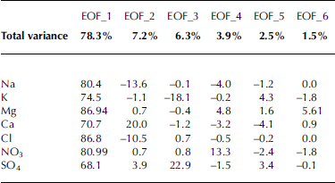
Each chemistry species has multiple potential sources, so variability in the ice chemistry can reflect changes in aerosol precipitation efficiency, aerosol transport and source production (Reference Legrand and MayewskiLegrand and Mayewski, 1997). To capture the driving force that changes air-mass input, instead of source-related changes of individual chemical species, we employ empirical orthogonal function (EOF) analysis on our dataset (Table 1). EOF analysis is used to statistically evaluate the covariance of variables in a common dataset (von Storch and Zwiers, 2002). The derived EOF axes are orthogonal to each other and hence are statistically independent.
The first EOF axis captures 78.3% of the total variance contained in the VLG dataset, with contributions of all chemical species between 68% and 87% (Table 2). This makes the EOF_1 time series an effective representation of the aerosol input pattern to VLG, and suggests that ice chemistry concentration is largely related to atmospheric circulation patterns. If changes in the source production (e.g. changes in sea-ice cover or cyclonic activity) were the driving mechanism, we would expect the common variance in the dataset to be less (hence EOF_1 would represent a lower percentage of total variance), as each species would show a more individual pattern. The other five axes account together for only 21.7% of total variance and potentially reflect changes in source production. EOF_2 explains about 7% of total variance and is dominated by Na and Cl, which are negatively correlated to Ca. EOF_3 captures 6% of total variance and is dominated by SO4, which is negatively correlated to K. The variability captured in EOF_4 to EOF_6 explains, in each case, <5% of the total variance contained in the ice chemistry dataset.
EOF analysis on VLG snow chemistry data. Total variance row in bold type represents percentage of total variance captured in the particular EOF axis. Numbers represent percentage variability of the individual species captured in the particular EOF axis
We compare the EOF_1 time series with the sunspot record, an indicator of solar irradiance (Reference Lean and RindLean and Rind, 1998). The correlation between sunspot number record and annually resampled EOF_1 is statistically significant on the 97.6% level (r = 0.34, df = 42, p = 0.0239 (two-tailed). The visual comparison shows that within the dating uncertainty during periods of high (low) solar activity the EOF_1 time series shows a bias towards higher (lower) concentration (Fig. 3). While the correlation between 1957 and 1986 appears in phase within the dating uncertainty, the latest EOF peak lags the most recent solar activity peak more than could be explained by the EOF dating uncertainty alone. One explanation for the low aerosol concentration during AD 1989 could be unusual and prolonged snow cover in the MDV. Summer snow cover would largely eliminate the albedo difference between the MDV and the EAIS, and hence the influence of solar activity on the regional atmospheric circulation pattern. However, a record with better age control is needed to substantiate this hypothesis due to the larger age uncertainty in this part of the VLG record.
Covariance between sunspot number record and EOF_1 time series of VLG ice chemistry record.
In general, an empirical approach does not imply a cause–response relationship. In order to argue that the similarities observed in Figure 3 are not coincidental, the forcing mechanism has to be understood.
Solar energy pathway in victoria valley
Sunspot numbers are an indication of solar irradiance, though the VLG chemistry record has been shown to be sensitive primarily to the radiation that reaches the Dry Valleys surface once it has passed through the atmosphere (Reference Bertler, Mayewski, Barrett, Sneed, Handley and KreutzBertler and others, 2004). Sunspot activity influences certain wavelengths of the solar radiation spectrum more than others. While the 11 year cycle changes the intensity of ultra-shortwave frequencies by up to five orders of magnitude, the longwave output varies by less than one order of magnitude (Reference Lean and RindLean and Rind, 1998). Most of the ultra-shortwave radiation (ultraviolet and extreme ultraviolet) is absorbed or reflected by the upper atmosphere. Consequently, solar radiation that penetrates the atmosphere and reaches the MDV surface comprises only a small portion of the ultraviolet spectrum but most of the visible and infrared wavelengths. Those lower frequencies (visible and infrared) are relatively less affected by sunspot activity (Reference Lean and RindLean and Rind, 1998). Notwithstanding the observed covariability between the sunspot record and the EOF_1 axis of the aerosol chemistry data (Fig. 3), it seems unlikely that solar variability can cause such a strong effect in the regional atmospheric circulation pattern. This leads to the question, how can the small change in received energy due to solar variability affect aerosol deposition in the MDV?
As described earlier, large seasonal changes in the MDV radiation budget create a strong seasonal signal in aerosol deposition at VLG. We propose that times of low solar radiation output (low sunspot number count) are similar to the ‘winter’ circulation pattern, albeit subdued and averaged over years (Fig. 4a), and high solar radiation output creates ‘summer’-like air-mass input (Fig. 4b). The assumption is that while the high-albedo ice sheet is relatively insensitive to the slight changes in solar energy output (>90% of the energy is reflected), the dark, solar-energy-absorbent dry valleys are more sensitive to these changes (>70% of the energy is absorbed). In consequence, while the atmospheric circulation at the EAIS does not change detectably, providing the gravitational airflow regardless, Victoria Valley is more likely to create a slightly stronger (deeper) low-pressure system during higher solar output, which in turn enhances airflow from the Ross Sea across VLG and weakens the influence of EAIS airflow. While this change in prevailing wind direction at VLG is a small forcing, the effects in the ice-core record are profound due to the strong contrasts of the two competing air-mass sources: the EAIS with low aerosol concentration and the Ross Sea with up to four orders of magnitude higher aerosol concentrations. It is important to note that the assumption of detecting this relatively small change in the terrestrial energy budget in VLG ice is not due to a temperature change, but rather to the different radiative forcing caused by strong albedo differences in the region that switch between two very different airflows: ‘EAIS mode’ (Fig. 4a) and ‘Ross Sea mode’ (Fig. 4b). Thus, it is their different absorption properties, and not an absolute temperature change in the region, that make the MDV sensitive to the small energy change caused by solar variability.
Schematic model of air-mass input to Victoria Valley during (a) low solar radiation output and (b) high solar radiation output. Arrows indicate air-mass transport paths. Approximate location of the schematic transect is indicated in Figure 1 (A–A’) (modified after Reference Bertler, Mayewski, Barrett, Sneed, Handley and KreutzBertler and others, in press).
Conclusions
Ice chemistry data from the VLG suggest that, at least for the last 50 years, aerosol deposition in the MDV has been sensitive to solar variability. We argue that the sensitivity is caused by strong albedo differences between ice-free valleys and the EAIS. However, more research is needed to investigate further direct forcing pathways, as well as indirect and feedback mechanisms, such as snow and cloud cover. Nonetheless, based on this gradient, solar activity might also be important on a larger, regional scale, where there are similar gradients in absorption, such as between East Antarctica and the Southern Ocean. However, slow response times of the ocean and a more complex climate system obscure a direct climate response to external solar forcing, making it more difficult to detect than in the simple climate system of the MDV. A longer, well-dated record from the MDV is needed to test if the solar variability signal is consistently contained in the ice-core record before this method might be used to reconstruct solar variability throughout the Holocene.
Acknowledgements
We especially thank A. Pyne, T. Kingan and B. Koçi for logistical and technical support. We are grateful for the support of Antarctica New Zealand, Ice Core Drilling Services – University of Wisconsin, the US National Science Foundation Office of Polar Programs, Scott Base and McMurdo Station. This project is funded by Victoria University of Wellington, Institute for Geological and Nuclear Sciences, the Royal Society of New Zealand (grant No. 00-CSP-21-BERT) and the Foundation for Research, Science and Technology (contract No. VUWX0203).


