

Introduction
In the water-limited U.S. Southwest, the dynamic interplay between the arid setting and sedentary Ancestral Pueblo farmers resulted in an uncertainty that pervaded society, with unpredictable rainfall often providing insufficient moisture for maize agriculture. In particular, some researchers identify Chaco Canyon, located in the San Juan Basin of New Mexico, as an “unlikely setting” for substantial occupation (Lekson Reference Lekson2006: 9). Despite concerns about the environmental feasibility for occupation and debates over population size, the Canyon served as a social and political centre of Pueblo society from AD 800–1130 (Figure 1). Large multi-storeyed pueblos—known as great houses—were concentrated within a 17 km-long portion of the Chaco Wash, now preserved as the Chaco Culture National Historical Park (Lekson Reference Lekson2006; Heitman & Plog Reference Heitman and Plog2015). Additionally, hundreds of small sites were constructed and occupied throughout the canyon, suggesting a sizable local population (McKenna & Truell Reference McKenna and Truell1986; Sebastian Reference Sebastian1992). The persistence of Chaco society for over 300 years indicates a remarkably sustainable system, but how this sustainability was achieved within an unpredictable environmental setting remains uncertain.
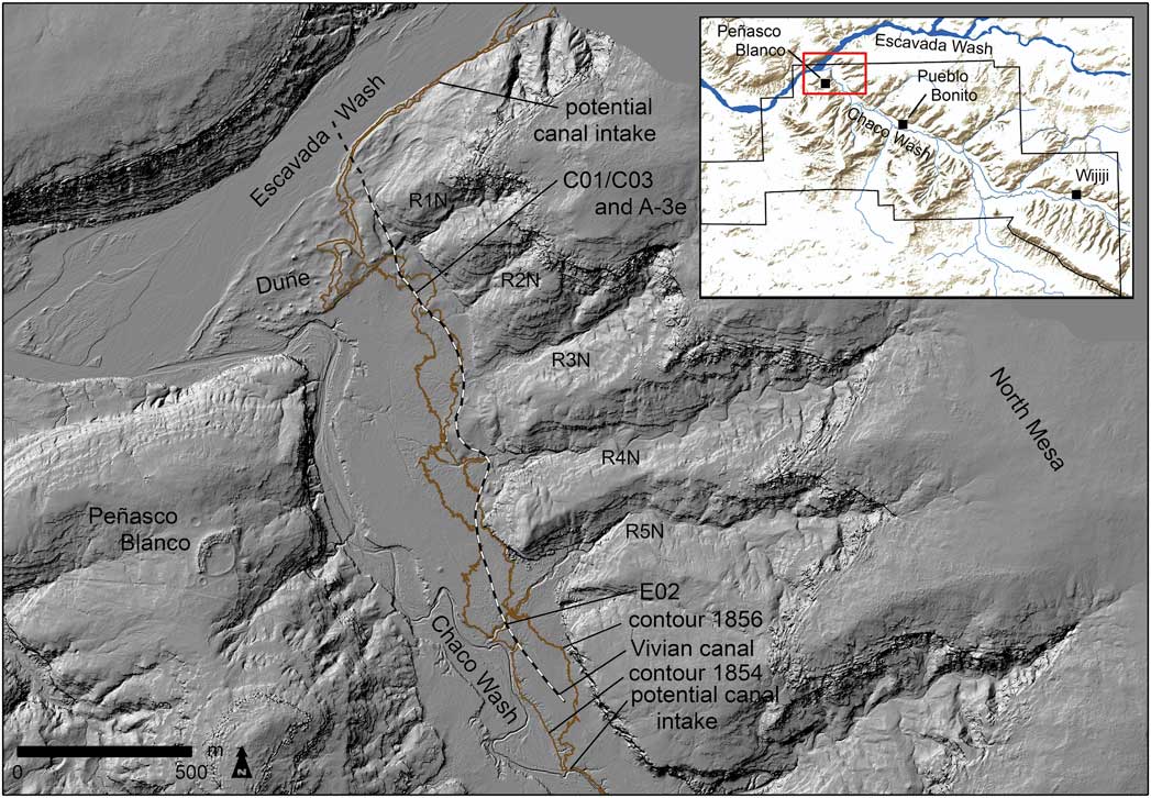
The dune end of Chaco Canyon where the Chaco Wash joins the Escavada Wash. The ‘Vivian canal’ was digitised from the Gordon Vivian map c. 1964 (CHCU-55430 1971 and online supplementary material (OSM) 7). The National Park boundary (in black) and the outline of this map (in red) are shown on the inset. Figure created by the authors.
Debates over whether food was grown locally or supplied from distant settlements dominate the literature (e.g. Cordell et al. Reference Cordell, Toll, Toll and Windes2008; Benson Reference Benson2016; Tankersley et al. Reference Tankersley, Dunning, Thress, Owen, Huff, Fladd, Bishop, Plog, Watson, Carr and Scarborough2016; McCool et al. Reference McCool, Fladd, Scarborough, Plog, Dunning, Owen, Watson, Bishop, Crowley, Haussner, Tankersley, Lentz, Carr and Thress2018). Arguments for the importation of maize, the staple crop, centre on two limiting factors: soil quality and water scarcity. Here, we examine the issue of water availability. Given the scarcity and unreliability of rainfall, technological advancements in water management were necessary for successful local agricultural production (Scarborough Reference Scarborough2003). While the presence of complex canal systems has long been noted (e.g. Vivian Reference Vivian1990), the difficulty in dating these constructions has led to doubts over their existence and utility (e.g. Benson Reference Benson2016; Wills Reference Wills2017). Our recent fieldwork on one canal network definitively dates it to Chaco’s Bonito Phase occupation (AD 800–1130), using optically stimulated luminescence (OSL) dating supplemented with AMS radiocarbon dates (online supplementary material (OSM) 1). We address the implications of this canal system (as well as others studied by R.G. Vivian) for the complexity of Chaco Canyon occupation, as water-flow coordination required flexible and quick responses from the local population. Pueblo social and political organisation, both past and present, is heavily integrated with ritual practices that help structure responses to the uncertain environment, including organising the labour necessary to maintain water-management infrastructure.
Environmental unpredictability
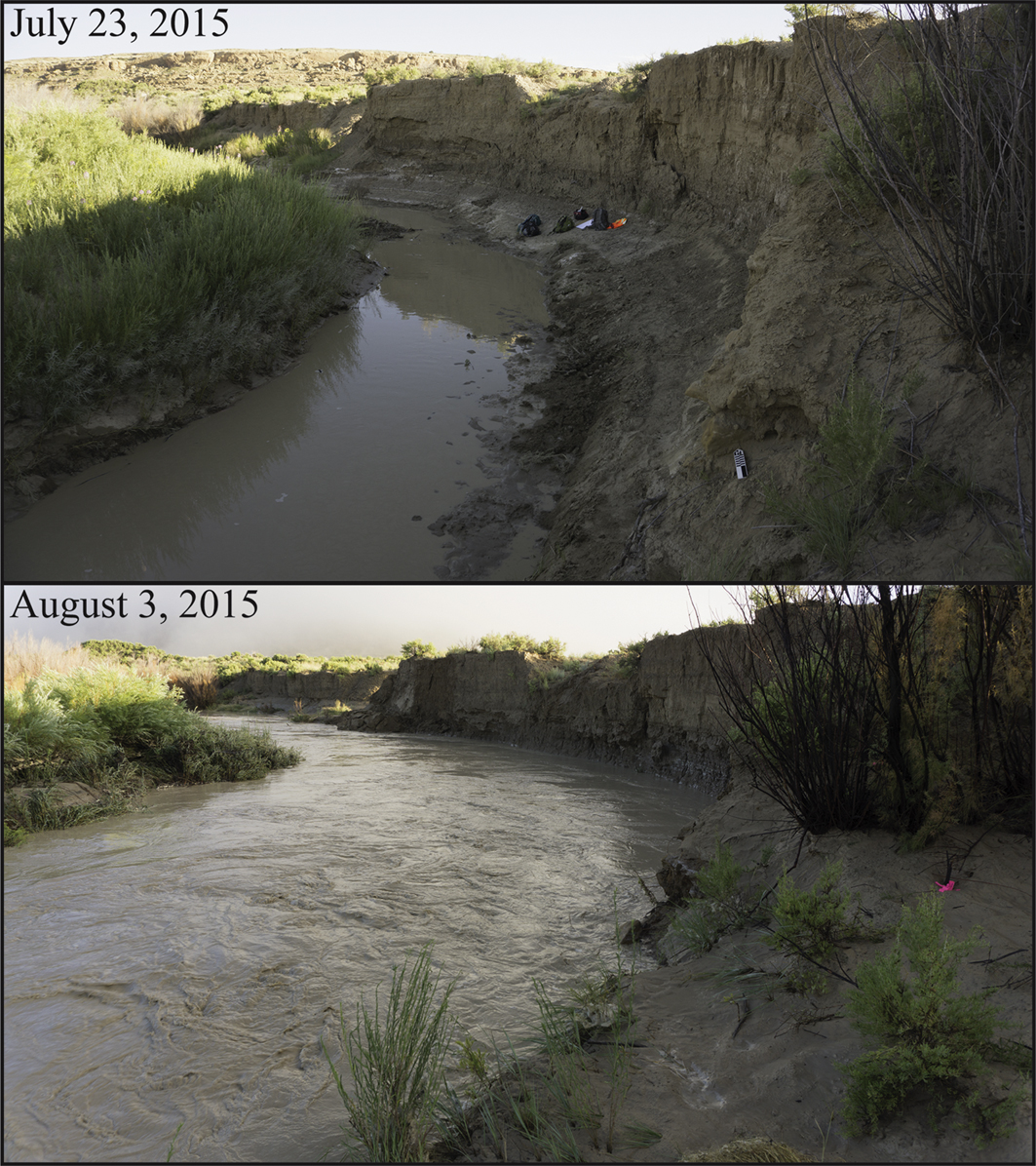
As the regional rainfall regime and the accessibility of water in the Chaco Wash can change rapidly, current conditions make for poor predictors of the past (Figure 2). Today, the Wash is deeply incised into valley-fill sediments, making flood-recessional farming or water-diversion irrigation nearly impossible. This, however, represents but one extreme in the oscillations between arroyo incision (or downcutting) and alluvial aggradation (or infilling) since the Middle Holocene (Bryan Reference Bryan1954; Hall Reference Hall1977, Reference Hall2010; Love Reference Love1980). Observations in the 1800s indicate that the Wash was not entrenched at that time. The current degree of incision therefore has occurred within the last 150 years:
The [sic] cañon is here about 500 yards wide, and is perfectly level from one side to the other […] Lieutenant Simpson passed through the cañon in August, and mentions that at this place there was a width of 8 feet, and a depth of 1½ feet of running water in the arroyo (Jackson Reference Jackson1878: 437; see also Simpson Reference Simpson1850).
Two views of the ‘horseshoe-bend’ of the Chaco Wash showing about a 1.5m water rise. Although the photographs were taken 11 days apart, the water rise occurred overnight. Photographs and figure created by the authors.
Recent research also demonstrates the dynamism of north-western New Mexico arroyo watersheds. Friedman et al.’s (Reference Friedman, Vincent, Griffin, Scott, Shafroth and Auble2014: 626) analysis of living tree rings in relation to deposited sediment along arroyo drainage margins shows that measurable depositional changes could occur “at the scale of minutes to hours” (Friedman et al. Reference Friedman, Vincent, Griffin, Scott, Shafroth and Auble2014: 627).
Generally, the San Juan Basin has limited annual precipitation of about 200 mm, with yearly fluctuations common and spatial distribution varying greatly. Precipitation in the ninth and tenth centuries AD experienced decadal fluctuations that became more consistent over time. Nevertheless, greater precipitation during the Bonito Phase may have increased options and opportunities for local agriculture. Except for 15 years, the period from AD 990–1115 received higher than average precipitation; this was followed by a significant drought, often assumed to be associated with canyon depopulation around AD 1130 (Sebastian Reference Sebastian1992; Dean & Funkhouser Reference Dean and Funkhouser2002; Vivian et al. Reference Vivian, van West, Dean, Akins, Toll and Windes2006).
Agricultural strategies
Potential agricultural productivity within Chaco Canyon remains a debated topic (e.g. Vivian Reference Vivian1974, Reference Vivian1990; Sebastian Reference Sebastian1992; Dorshow Reference Dorshow2012; Benson Reference Benson2016; Wills Reference Wills2017). Questions about agricultural feasibility are linked, in part, with the salinity of the floodplain soils. A thorough review of arguments concerning salinity can be found in other papers (e.g. Wills & Dorshow Reference Wills and Dorshow2012; Benson Reference Benson2016), but our research contends that modern salinity levels are low enough to permit farming and, given their susceptibility to spatial and temporal fluctuations, ultimately provide a poor measure of past agricultural potential (Tankersley et al. Reference Tankersley, Dunning, Thress, Owen, Huff, Fladd, Bishop, Plog, Watson, Carr and Scarborough2016; McCool et al. Reference McCool, Fladd, Scarborough, Plog, Dunning, Owen, Watson, Bishop, Crowley, Haussner, Tankersley, Lentz, Carr and Thress2018). The recent revival of interest in Chaco agriculture, however, has highlighted the utilisation of a variety of past water-management systems that either have been documented archaeologically or were practised historically by Navajo farmers. These include floodplain, slope wash and ak chin (floodwater) farming (Vivian & Watson Reference Vivian and Watson2015: 35–54). Archaeological features include terraces, check dams and canals (Vivian Reference Vivian1990; Wills & Dorshow Reference Wills and Dorshow2012; Vivian & Watson Reference Vivian and Watson2015: 36–42).
On the floodplain, Vivian’s (Reference Vivian1974, Reference Vivian1990) excavations revealed multiple elaborate canal systems, largely concentrated on the north side of the canyon. These systems involved diversion gates of masonry, canals and fields—including a gridded field system first identified by Gordon Vivian, and located near the Chetro Ketl great house (Vivian & Mathews Reference Vivian and Mathews1965: 12). Sturm (Reference Sturm2016) has found multiple overlaid field configurations in the area using ground-penetrating radar, while Wills et al. (Reference Wills, Love, Smith, Adams, Palacios-Fest, Dorshow, Murphy, Mattson and Crown2016) have identified a large channel that diverted floodwaters away from Pueblo Bonito, the central great house. Despite documentation of canal systems, the timing and effectiveness of these constructions for agriculture is often questioned—due in part to the lack of direct dating (e.g. Benson Reference Benson2016; Wills Reference Wills2017). We used a multi-faceted approach to address these concerns and to advance our understanding of the varied agricultural systems that supported the local population during the Bonito Phase.
Recent excavations
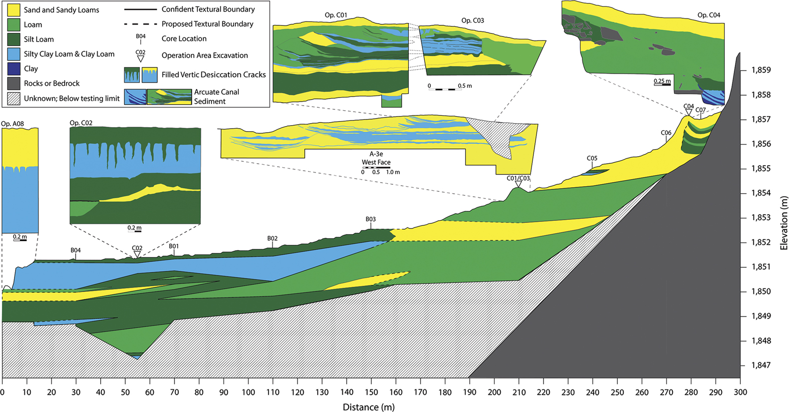
Our work in Chaco Canyon has involved sediment coring, arroyo sidewall sedimentary profiling, and excavation at both ends of the National Park’s south-east and north-west boundaries (Watson et al. Reference Watson, Holeman, Fladd, Bishop, Conger and Morrow2014; Scarborough et al. Reference Scarborough, Carr, Dunning, Fladd, Bishop, McCool, Haussner, Thress, Owen, Tankersley, Watson and Plog2016) (Figure 1). We focused particularly on a zone at the confluence of the Chaco and Escavada Washes—often referred to as the ‘dune dam’ area. Peñasco Blanco, a great house on the mesa to the south, occupies an elevated and commanding vantage point. The greater dune dam area encompasses approximately 10km2 (from the dune to rincon 5) of alluvium deposited from early meanders of the Chaco Wash, runoff from the North Mesa, and aeolian sands associated with dune development. Force et al. (Reference Force, Vivian, Windes and Dean2002) posited that the large linear sand dune functioned as a dam for the Chaco Wash during the Bonito Phase, although this hypothesis is controversial (Hall Reference Hall2010; Love et al. Reference Love, Gillam, Benson, Friedman, Miller and Vincent2011). Our data suggest the periodic deposition of clay-rich sediment—indicative of pond formation—behind the south-western end of the dune and in proximity to the present course of the Chaco Wash. This was followed by soil formation (vertisol), possibly stimulated by local base-level stability. An exposed profile from one cut-bank of the heavily incised lower ‘horseshoe bend’ within the Chaco Wash (Op. A08) and another from a test excavation 100m north-east of the horseshoe-bend (Op. C02) indicate post-AD 400 clay deposition associated with widespread vertisol development (Figure 3) (Haussner Reference Haussner2016) (OSM 2).
Fence diagram representing the soil/sediment textures from the dune dam area in Chaco Canyon. The line runs from the Chaco Wash to the North Mesa. For detailed depictions of individual units, see profiles in the other figures and OSM 2. Figure created by the authors.
Canal profiles
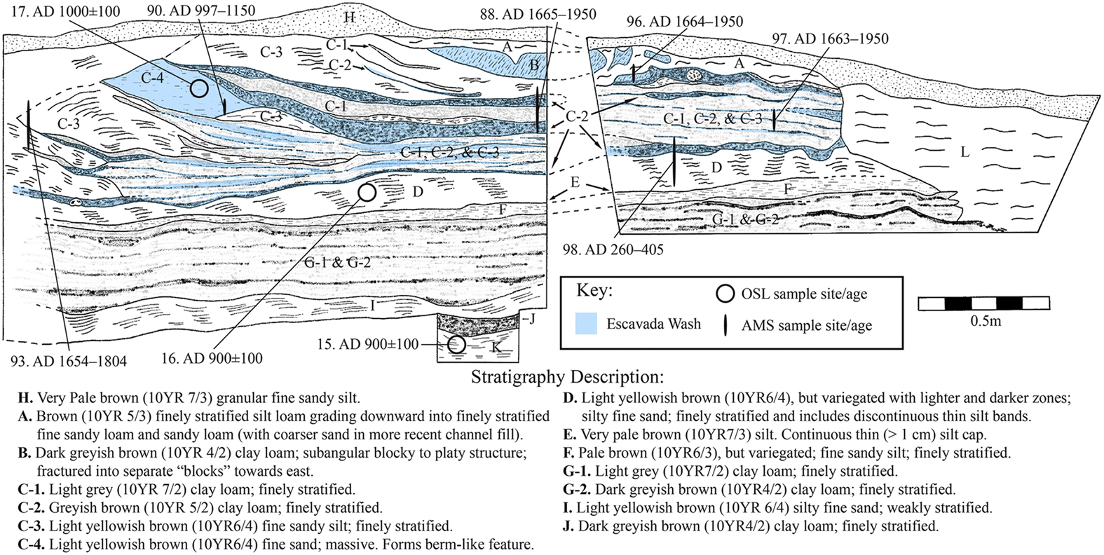
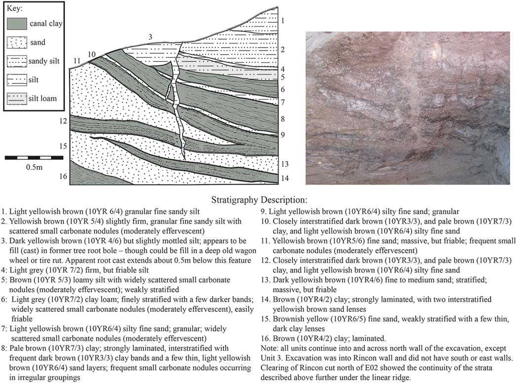
In the 1960s, Gordon Vivian carried out work in this area to investigate the local water-management system. Continuing this research during the 1970s, Vivian (Reference Vivian1990) excavated several canal profiles running between the Chaco Wash and the North Mesa. The most revealing profile (Op. C01/C03) from our recent work consists of two 2×1m excavation units that re-exposed a set of canals originally revealed in Vivian’s A-3e profile (Reference Vivian1971) (Figure 4). Vivian’s long trench also exposed a smaller channel immediately to the south (Figure 5). The lowest unit (K) identified in Op. C01 comprises sterile sands and silts—probably a former floodplain surface. Unit K, underlying the smaller channel visible in Vivian’s profile, produced an OSL age of AD 900±100 (OSM 3).
Profile of Ops. C01/C03 showing stratigraphy, sediment sourcing (uncoloured layers sourced to the Chaco Wash/rincons), and the locations of OSL/AMS ages. The numbers next to the OSL ages refer to Chaco 2015-XX in OSM 3. The numbers next to the AMS ages refer to DD-XX in OSM 4. Figure created by the authors.
Comparison of R. Gwinn Vivian’s A-3e profile (bottom) and Ops. C01/C03 profile (top). Grey layers represent canal clays. Figure created by the authors.
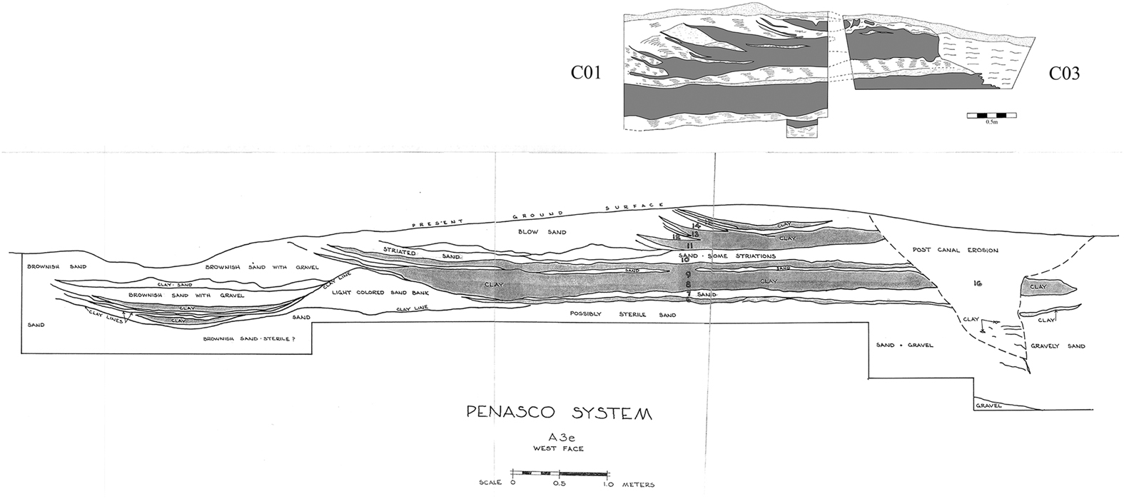
The smaller channel is a natural shallow extension of a rincon drainage (an incised, erratically flowing seasonal channel pouring off the flanks of an exposed bedrock mesa) extending onto the floodplain that was culturally modified by berm construction, or an early opportunistically constructed canal. Unit J is the first fluvial deposition layer encountered in Op. C01 within a second larger, more recently constructed canal. The creation of this canal suggests increasing water demands tied to agricultural intensification. In Vivian’s excavation (1971), the southern margin of the initial phase of the larger canal was revealed as a 0.5–6m-high sandy berm with a clay cap. This same berm forms the northern margins of the adjacent smaller channel; the two canals may have been briefly contemporaneous. Most of the larger channel, however, formed after the abandonment of the smaller channel. Gravel and sand deposits within the smaller channel indicate that it experienced a period of high-energy flow prior to abandonment. Post-abandonment, the smaller channel infilled further, and the southern berm of the larger northern canal was elevated.
Unit I in the large canal consists of stratified fluvial sands deposited during a period of moderately swift water movement. This was followed by a prolonged period of well-controlled water flow during which stratified clay and clay loam fluvial sediments were laid down (units G-1 & G-2). The overlying unit F comprised cross-bedded silts and sands resulting from aeolian deposition—a period during which the canal was not in use. The final aeolian deposit was a distinct brittle silt cap (unit E), which was absent at the southern extreme of Op. C01, where later scouring probably removed it along with a small portion of unit F. The scouring marked the renewal of water flow, which then resulted in the successive deposition of stratified silty fine sand of unit D. Unit D produced an OSL age of AD 900±100 (OSM 3).
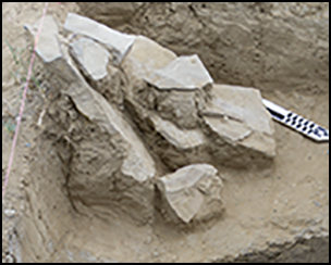
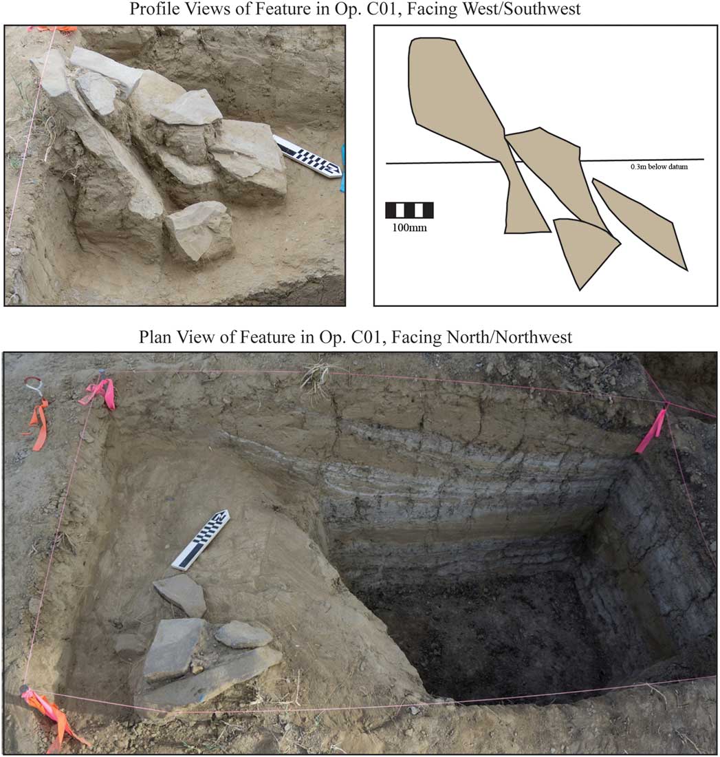
Subsequently, the canal was modified by the construction of a series of successive berms (units C-3 & C-4). These berms significantly narrowed the width of the canal as the elevation of the floor continued to rise via aggradation—chiefly from the clay loam sediments of units C-1 and C-2 that indicate slower water flow. Vertically positioned flagstone slabs to divert water were also encountered at this level. These probably served to spread irrigation waters (Figure 6). Unit C-4 produced an OSL age of AD 1000±100 and an AMS radiocarbon age of 985±20 BP (UCIAMS-167243: AD 997–1150 at 95.4%; date modelled in CALIB v.7.10, using the CALIB radiocarbon calibration curve) (Stuiver et al. Reference Stuiver, Reimer and Reimer2017) (OSM 3–4). The narrowing of the canal and return to clay-rich sediments (units C-1 & C-2) probably indicates efforts to maintain flow as water availability dropped.
Stone feature on the edge of the canal sediments in Op. C01. Figure created by the authors.
The use-history of the canal becomes increasingly hard to discern in the uppermost parts of Ops. C01/C03 due to later erosion and soil-formation processes, including bioturbation (e.g. rodent burrows, ant nests and plant roots). Thin lenses of clay loam fluvial sediment (the uppermost examples of C-1 and C-2) were embedded within a narrowing channel formed of silt and sand (unit C-3). The increased narrowing further suggests greater difficulty in harnessing water. The last fluvial deposit within the canal is the highly pedogenically altered unit B (or those processes in this case by which recently relocated sediments now resemble organically rich soils), possibly representing a final effort to harness water. Unit L, located on the edge of Op. C03, indicates the destruction of the canal by erosion. Whether this erosion occurred at canal abandonment, or later, is unclear.
Canal source and use-histories
Given the range of OSL ages from the three sampled areas in Op. C01, dating the big canal and its history is imprecise. It is, however, indisputably an Ancestral Puebloan feature created sometime after AD 800, and was in use possibly as late as the early twelfth century. The similarity of the three OSL samples and their overlapping age ranges suggest that the system evolved fairly quickly, perhaps in as little as a century. The young AMS ages from Ops. C01/C03 (Figures 4 & 6) are disputable given the significant bioturbation in the upper units of the profile. The old radiocarbon AMS age was derived from charcoal probably introduced by water flow through the channel. To assess whether water sources can be distinguished, modern alluvium and waters collected from the Chaco Wash, North Mesa rincons and the Escavada Wash were analysed with energy-dispersive X-ray fluorescence spectrometry (ED-XRF), and strontium isotopes (87Sr/86Sr) were measured. ED-XRF revealed two distinct signatures: the Escavada Wash and Chaco Canyon, the latter comprising the samples collected from the Chaco Wash and the North Mesa rincons. Comparing these signatures to sediment samples collected from Ops. C01/C03 indicates that the majority of the layers derive from the Chaco Wash or the adjacent rincons; three layers, however, source to the Escavada Wash, suggesting that the canals tapped multiple water sources over time (OSM 5). Unit C-2, which is closely interbedded with unit C-1, sources to the Escavada Wash, and represents a period during which multiple sources were tapped, probably in quick succession. These deposits were deliberately embanked by relocating mixed matrices from within the canal or the nearby Escavada Wash (unit C-4). Unit B—the final fluvial deposit within the canal—also sources to the Escavada Wash, perhaps denoting a last attempt to harness this more dependable water source. Vivian (CHCU 55430 1971) suggested that the Escavada Wash was partially diverted up-canyon in this dune zone (Figure 1). Our ground-truth and LiDAR assessments indicate that such a diversion was possible, although the present linear dune blowing off the most western margins of the North Mesa and down the Escavada Wash obscures any direct evidence for such a diversion.
Strontium isotope data also corroborate multiple diversion strategies. Waters collected from the Chaco and Escavada Washes just above their confluence are isotopically distinct, with two nearby sampled rincons having intermediate ratios (OSM 6). A similar isotopic range is observed in core sediments that were collected from the edge of the bend in the Chaco Wash. At a depth of 2.09–2.19m, sediments isotopically resemble the Chaco Wash. At depths of 0.9–1m and 0.4–0.5m, however, sediments have higher ratios, suggesting an influx of material from the Escavada Wash and possibly the rincons—a similar stratigraphic sourcing history to the well-defined canal deposition discussed above. Future isotopic analyses of canal sediments may further disentangle phases of water diversion and sediment deposition.
Other canals
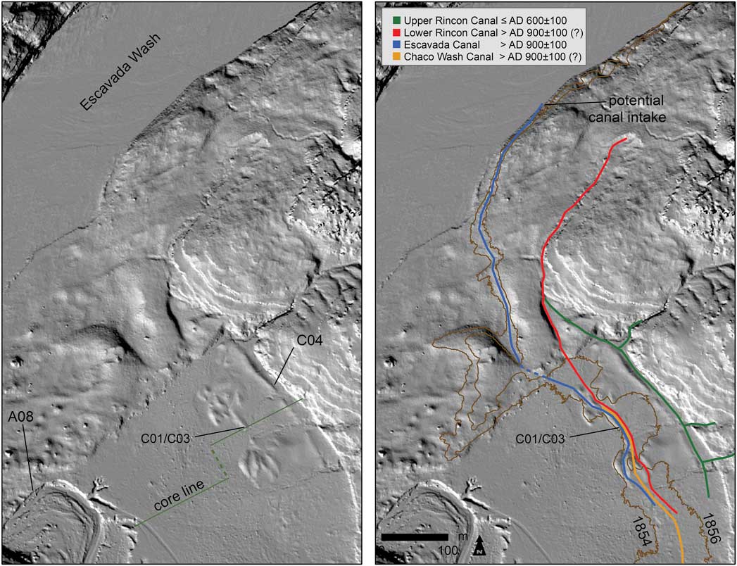
Waters from both the Chaco Wash and the North Mesa rincons were probably channelled by the Ops. C01/C03 canals. Today, water intake from the Chaco Wash appears unfeasible, but its current incised course—about 7m below and 150m to the south-west of Ops. C01/C03—probably differs from that in the past, given the dynamic environmental setting. A LiDAR-derived hillshade image of the dune dam area indicates several probable canal paths traversing the local landscape (Figure 7). The LiDAR-derived contour lines at 1856 and 1854m demonstrate the hydrological plausibility of canals feeding from either the Escavada or Chaco Washes (Figure 1). These paths follow gentle gradients of about 1 per cent; the precise gradient of any canal, however, is difficult to determine due to the disruptive effects of erosion and aggregation, and the presence of stacked canal segments within our exposed profile. The breadth of the canals located in our excavation suggests adequate amounts of water for agriculture, possibly involving the diversion of a significant flow from the Chaco Wash from farther upstream (OSM 7). While canals connecting Ops. C01/C03 to the Chaco Wash would be long, a probably contemporaneous canal of similar length located at Kin Bineola (a great house 30km away), ran for over a kilometre to connect an intermittent stream to associated fields (Lyons Reference Lyons1977; Vivian Reference Vivian1990: 47, 70, 377; Vivian & Palmer Reference Vivian and Palmer2002). Additionally, excavation has revealed a canal (Op. E02) along the edge of the Chaco Wash, near the anticipated intake for those documented in Ops. C01/C03 (Figure 8). While these canal profiles cannot be definitively linked, they suggest an extensive local canal system.
Left: LiDAR-derived hillshade image showing our operations and the ridges in the alluvial plain, which carry the canal remnants. Right: hypothesised canals and LiDAR-derived elevation contour lines (1856 m and 1854 m), which bracket hydrologically plausible canals feeding from either the Escavada or Chaco Washes. Figure created by the authors.
Profile of Op. E02 showing the partial outline of a canal near the possible upstream intake along the edge of the Chaco Wash. Figure created by the authors.
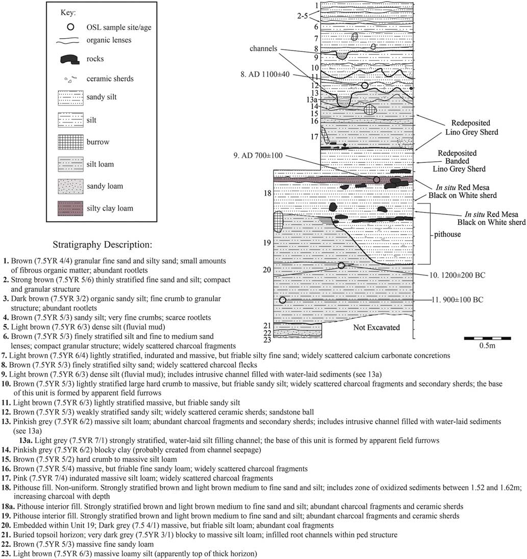
The LiDAR-derived hillshade image (Figure 7) also reveals a canal running along the foot of the North Mesa, a portion of which was exposed by a 2×1m excavation (Figure 9). Op. C04 contains evidence of canal deposits dating to the Late Basketmaker period (AD 500–750), based on an OSL age of AD 600±100 (OSM 3). The location of this canal makes the rincons the most probable source and supports Vivian’s (Reference Vivian1972) assessment that most known stone-lined irrigation features within the canyon are associated with North Mesa rincon sources (see Wills et al. Reference Wills, Love, Smith, Adams, Palacios-Fest, Dorshow, Murphy, Mattson and Crown2016). Vivian (Reference Vivian1990) documented sandstone-slab head gates and canal segments around 1km up-canyon from Op. C04. The presence of multiple canal segments that fed from different sources within close proximity of one another supports the existence of a highly flexible and developed local system for allocating water.
Plan and profile views of Op. C04 illustrating a Basketmaker III canal along the edge of the rincons. The numbers next to the OSL ages refer to Chaco 2015-XX in OSM 3. The numbers next to the AMS ages refer to DD-XX in OSM 4. Figure created by the authors.
Roberts Great House
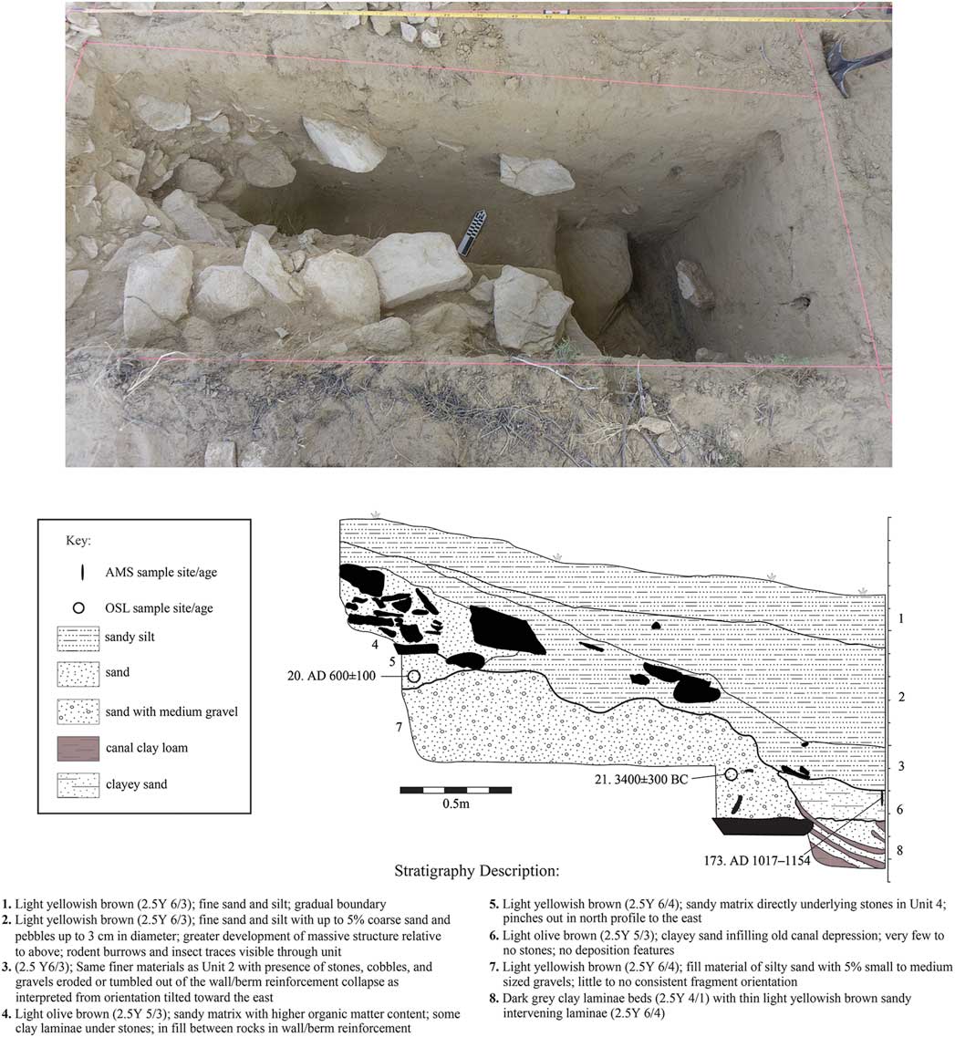
Although the focus of this article is the lower far reaches of the Chaco Wash, our work at Roberts Great House, located near Wijiji, also accentuates the highly dynamic setting (see Roberts Reference Roberts1926) (Figure 1). This incomplete great house was covered by nearly a metre of sediment, and the later cut of an adjacent arroyo flanking the architecture has exposed the structure’s deeply eroded western margins. Our OSL ages indicate that the great house was buried soon after its foundations were constructed around the twelfth century (OSM 8). More dramatic evidence of marked alluviation is apparent within another arroyo profile from the same rincon, slightly south-east of Roberts Great House (Figure 10). Near the head of this arroyo cut, our profiling and dating revealed an early ninth-century pithouse buried under approximately 2m of slope wash. The upper reaches of the profile exposed runnels or channels suggestive of irrigation that was probably coeval with the great house centuries later. While nuanced histories of canal segments were not revealed in this portion of the canyon, multiple agricultural strategies were probably employed to support local populations.
Op. 100 profile located at the east end of Chaco Canyon showing rapid alluviation. The numbers next to the OSL ages refer to Chaco 2014-XX in OSM 3. The numbers next to the AMS ages refer to DD-XX in OSM 4. Figure created by the authors.
Canals and agriculture
Within the dynamic setting of Chaco Canyon, our recent excavations and analyses demonstrate the exploitation of multiple water sources. Water from these canals could certainly have been used for domestic purposes, but agriculture best explains their location within the floodplain. Early canals probably gathered and directed runoff from the nearby rincons, as exemplified by the canal in Op. C04. Later, waters from the Escavada and Chaco Washes—in combination with rincon waters—were diverted for agricultural use into more complex systems of artificial channels or earthen canal segments. These canals were stacked or reused during the ninth and tenth centuries, with their elevated, infilled courses possibly re-used during the historical Navajo period (Figure 4). When added to Vivian’s evidence (1990) for stone-slab-lined canal segments and diversion gates, it is apparent that a highly complex set of risk-aversion strategies was in place that utilised water from multiple independent sources. While our fieldwork emphasises the use of canal irrigation within Chaco Canyon, this represents just one piece of a multifaceted agricultural management system that was tailored to the local environmental conditions (Vivian & Watson Reference Vivian and Watson2015).
Discussion and conclusions
Evidence from our fieldwork confirms the long-suspected operation of canal irrigation in portions of Chaco Canyon between AD 800 and 1130. Quick social responses to the dynamic setting were necessary to harness multiple water sources through the canal system below Peñasco Blanco—probably drawing upon labour provided by occupants of the great houses and the numerous small sites throughout the canyon. To combat environmental unpredictability and coordinate the construction and maintenance of the hydrological infrastructure, social responses must have been structured through leaders, whose actions reduced risk and uncertainty.
Most explanations for the management of food production within Chaco concentrate on the occupants of the great houses, as these sites were located close to desirable agricultural settings (e.g. Dorshow Reference Dorshow2012; Wills & Dorshow Reference Wills and Dorshow2012; cf. Fendon Reference Fendon1959). North American ethnographic research suggests that the societal emphasis on horticulture—often involving substantial female labour investment—correlates with matrilineality and matrilocal residence (Driver & Massey Reference Driver and Massey1957: 432). Ware (Reference Ware2014) also suggests that ethnographic explanations for both matrilineality and matrilocality revolve around a localised agricultural base controlled by women (cf. Steward Reference Steward1955). Supporting the potential link between agricultural production and matrilineality, a recent archaeogenomic study of a rich burial cluster from within Pueblo Bonito identified a matrilineal connection among the burials. These date from the founding of the great house and continue throughout much of its occupation (Plog & Heitman Reference Plog and Heitman2010; Kennett et al. Reference Kennett, Plog, George, Culleton, Watson, Skoglund, Rohland, Mallick, Stewardson, Kistler, LeBlanc, Whiteley, Reich and Perry2017). The existence of prominent matrilineal groups who could oversee, if not direct, the farming efforts may explain the successful adaptation of the canal system to highly uncertain environmental conditions. This association persists in the U.S. Southwest today, as ties between Pueblo ritual leaders and water management are recorded ethnographically (e.g. Parsons Reference Parsons1939; Ortiz Reference Ortiz1969: 106).
Additional support for the linkage between ritual leadership, matrilineality and water-management systems tied to agricultural resources can be found in the material assemblages within or near the Pueblo Bonito burial cluster. In addition to a range of non-local materials suggesting long-distance ties and ritual authority (Neitzel Reference Neitzel2003; Crown & Hurst Reference Crown and Hurst2009; Watson et al. Reference Watson, Plog, Culleton, Gilman, LeBlanc, Whiteley, Claramunt and Kennett2015), many of the materials are ethnographically documented symbols of moisture and fertility throughout the Southwest, such as turquoise and frog/tadpole effigies (Plog Reference Plog2003, Reference Plog2011). These symbols suggest that links to water and agricultural success were important aspects of ritual practice tied to the elite occupants of great houses. Ritual is intimately intertwined with economics and politics in the Pueblo Southwest (e.g. Fowles Reference Fowles2013), and potentially marked or legitimised the matriline’s authority in water-management decisions. Ritual practice, economic access and political authority tied to moisture and fertility almost certainly allowed for the deployment and management of a labour force that responded quickly to environmental change. The centralisation of leadership may, in part, have sustained the Chaco social system by establishing certainty in the face of unpredictable environmental factors.
Many forces surely triggered the cascading social developments within Chaco Canyon (Watson et al. Reference Watson, Plog, Culleton, Gilman, LeBlanc, Whiteley, Claramunt and Kennett2015; Kennett et al. Reference Kennett, Plog, George, Culleton, Watson, Skoglund, Rohland, Mallick, Stewardson, Kistler, LeBlanc, Whiteley, Reich and Perry2017). The dynamic interplay of rapid sedimentation, reciprocal erosional processes and the necessity of monitoring and containing soils for cropping must have markedly influenced how labour deployed. The social context for this dynamism necessitated attempts to reduce risk in order to produce an adequate food supply. Due to the erratic rainfall patterns, diverse strategies were employed to increase the predictability of water availability for farming. Our data suggest that rincon runoff sources were initially diverted, while more formal distributary canalisation sourced from both nearby washes developed later as Puebloan infrastructure advanced. Nevertheless, uncertainty was always a concern. The development of social controls to monitor diverse water sources and deploy labour in order to maintain established water-management systems was necessary to ensure quick responses to the dynamic local environmental conditions—responses that were fundamental to the success of Chaco society.
Supplementary material
To view supplementary material for this article, please visit https://doi.org/10.15184/aqy.2018.114
Acknowledgements
Funding from the University of Cincinnati Research Council, the Charles Phelps Taft Foundation, and the Deans of the College and Graduate School of Arts and Sciences at the University of Virginia and the University of Cincinnati supported this study. We are especially grateful to the National Park Service, Chaco Culture National Historical Park, the New Mexico Office of Archaeological Studies, the Navajo Nation and members of the American Indian Advisory Council to the National Park Service. This work was accomplished under U.S. department of the interior permit 15-CHCU-01. We are equally grateful to Gideon Bartov and Tom Johnson (UIUC) for assisting with the Sr isotope analysis. We also owe special thanks to Warren Huff, Venicia Slotten, Jessica Thress, Josh Miller and Douglas Dvoracek for their assistance and insights. Our team appreciates the careful assessment from the editors at Antiquity and the external reviewers, and extends special thanks to Barbara Mills for her invitation to submit to this recent research on Chaco Canyon in this special section.


