


Introduction
Traditionally, the inception of Neolithic lifeways in the Western Valleys of northern Chile is believed to have occurred during the early Formative Period (c. 2000 BC), with the introduction of domesticated plants and animals leading to a gradual decline in hunting and gathering. This transition was assumed to have given rise to social complexity, settled agricultural economies and residential clusters with long-range mobility (e.g. Núñez & Santoro Reference Núñez and Santoro2011; Muñoz et al. Reference Muñoz, Agüero, Valenzuela, Falabella, Uribe, Sanhueza, Aldunate and Hidalgo2016). Recent research suggests this transition was more protracted, pushing the date back to c. AD 650 in the highlands (Sepúlveda et al. Reference Sepúlveda, Cornejo, Osorio, Uribe, Llanos and Castillo2018; Calás et al. Reference Calás2023) and proposing that a stable hunter-fisher-gatherer lifeway persisted on the coast well into the colonial period (post-AD 1530) (Roberts et al. Reference Roberts2013; Gayó et al. Reference Gayó, Martens, Stuart-Williams, Fenner, Santoro, Carter and Cameron2020). A key economic continuity between the Archaic (8000–2000 BC) and Formative periods is the sustained exploitation of marine resources, extending to c. AD 1530 (King et al. Reference King, Millard, Gröcke, Standen, Arriaza and Halcrow2018), with local populations adopting new technologies while maintaining their traditional subsistence strategies. However, this perspective acknowledges that upland incursions were either limited or are yet to be traced and is based in settlement that was tethered to the lowlands (e.g. Eerkens Reference Eerkens, Barnard and Wendrich2008). In contrast, it is unclear whether different sets of foraging populations inhabited upland ecological floors of the piedmont (Precordillera) at 2500–3800masl (metres above sea level) and the High Plateau (Puna) from 3600masl upwards (Núñez & Santoro Reference Núñez and Santoro2011; Gayó et al. Reference Gayó, Martens, Stuart-Williams, Fenner, Santoro, Carter and Cameron2020).
Previous research is based on a restricted number of archaeological sites, providing only a partial view of past lifeways. Many of these sites are ephemeral—small campsites or simple structures with limited stratigraphic depth—and remain understudied. While many may not initially appear rich in data, these sites can offer valuable insights into mobility, seasonal occupation and broader landscape use in the Western Valleys (García & Ajata Reference García and Ajata2016; Saintenoy et al. Reference Saintenoy, Ajata, Romero and Sepúlveda2017). This is particularly relevant for understanding how people exploited local resources and reached distant locations, as this mobility may have relied on a network of short-occupation settlements. Similar patterns have been described for internodal sites that linked major points of interest, such as Pukaras (large, fortified settlements) and large settlements, particularly during the Late Intermediate (c. AD 1000–1450) and Late or Inka (c. AD 1450–1530) periods (Berenguer & Pimentel Reference Berenguer and Pimentel2017). However, these nodal links focus on complex, hierarchically structured social groups, rather than those subsisting on the margins or outside these forms of social organisation.
Temporal and historical discrepancies between ethnohistorical accounts and archaeological evidence in the Western Valleys are subtle but nonetheless significant. Colonial sources challenge the archaeological perspective of a gradual decline in foraging lifeways during the Formative period. Some records indicate that foraging persisted until the eighteenth century (Choque & Díaz Reference Choque and Díaz2022), when tribute records, though primarily based on economic rather than ethnic distinctions, still reflect a fundamental classification of indigenous groups according to their role in food production. At the broader South-Central Andes scale, those who did not fit within the economically valuable groups for colonial exploitation were classified as Uru or Uro (Millones & Schaedel Reference Millones and Schaedel1980; Julien Reference Julien1987). These groups were characterised by high mobility, a lack of surplus and hunting and gathering economies, though some practised mixed subsistence strategies (Casassas Reference Casassas1992). The broad generalisations associated with the Uru category resulted in the amalgamation of diverse groups—such as Pacific coastal foragers, riverine and lacustrine hunter-fisher-gatherer societies and Andean ungulate hunters—under a single label, though some finer distinctions do emerge, such as the Choquela Andean camelid-hunting ayllu (Julien Reference Julien1983: 33).
To build bridges between the data on pre-Hispanic and historic foragers, this study uses the Camarones River Basin to explore which features are visible in the landscape. In other words, it shifts from a limited sample of sites to consider the full range of archaeological features visible across the study region, with data drawn from a systematic review of archaeological sources and satellite imagery.
Covering such a vast landscape and broad chronological range presents a challenging and ambitious undertaking for a single study. To focus the discussion, the initial analysis concentrates on three macro-groups of archaeological sites—the most abundant types found within the basin. The first comprises small-scale settlements, defined as clusters of up to nine standing structures and enclosures. These are followed by larger settlements, including villages and pukaras, typically associated with the Late Intermediate and the Late or Inka periods, and characterised by groups of 11 or more enclosures. Finally, the analysis includes chacu, traps used for the capture of Andean ungulates that consist of funnel- or V-shaped installations made of dry-stone walls (each averaging around 150 metres in length), which converge at a final enclosure or capture area. Analysis of the distribution of these macro-groups demonstrates a second zonation of settlement patterns. Beyond the tethered landscape of coastal and lowland foraging groups, both small-scale settlements and chacu reflect a tethering to key upland resources, namely Andean camelids and deer, vital for subsistence and fibre exploitation. Furthermore, the distribution, quantity and density of these features suggest a foraging way of life, or at least the use of this landscape by foraging groups in conjunction with highly mobile herding populations operating between seasonal resource exploitation points.
The Camarones Basin
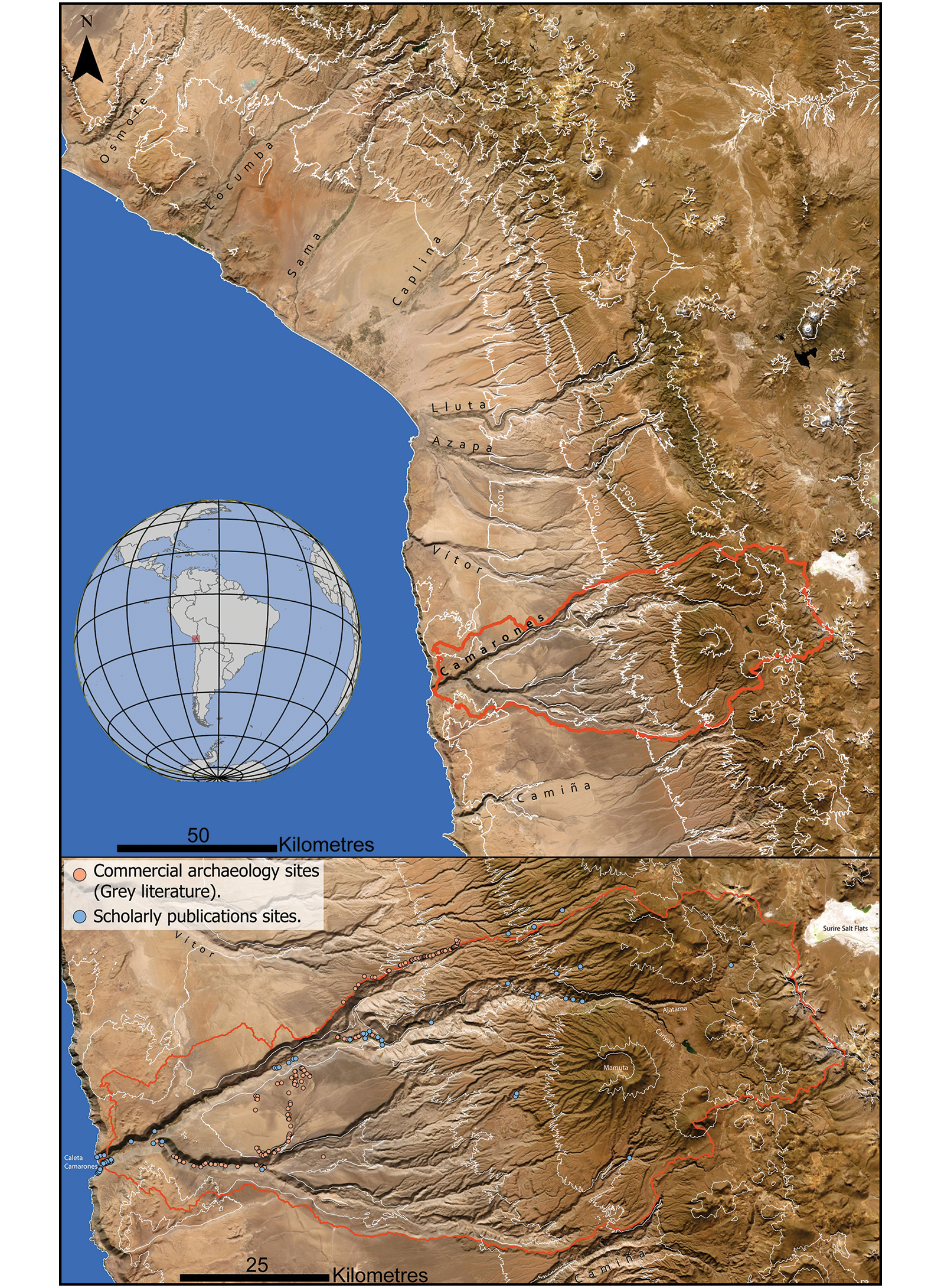
The Camarones River basin in northernmost Chile spans 4637km2, extending 127km from east to west and 52km from north to south (Figure 1). This watershed encompasses Chiza, part of Nama and several smaller streams that feed into the main Camarones River. The Western Valleys, including the Camarones basin, feature two distinct ecoregions: the Atacama Desert to the west, one of the driest places on Earth, and the Dry Puna to the east, with peaks approaching 6000masl. In their longitude, the Western Valleys form a steep staircase-like landscape from sea level to the high mountain Puna—a climb dramatically interrupted by ravines that reach depths of 1000m.
(Top) The Camarones Basin (red polygon) in the context of the Western Valleys; bottom) archaeological sites identified within the Camarones Basin prior to this work. Contour lines are shown at 1000m intervals on both maps (figure by author, basemap: Esri World Imagery).

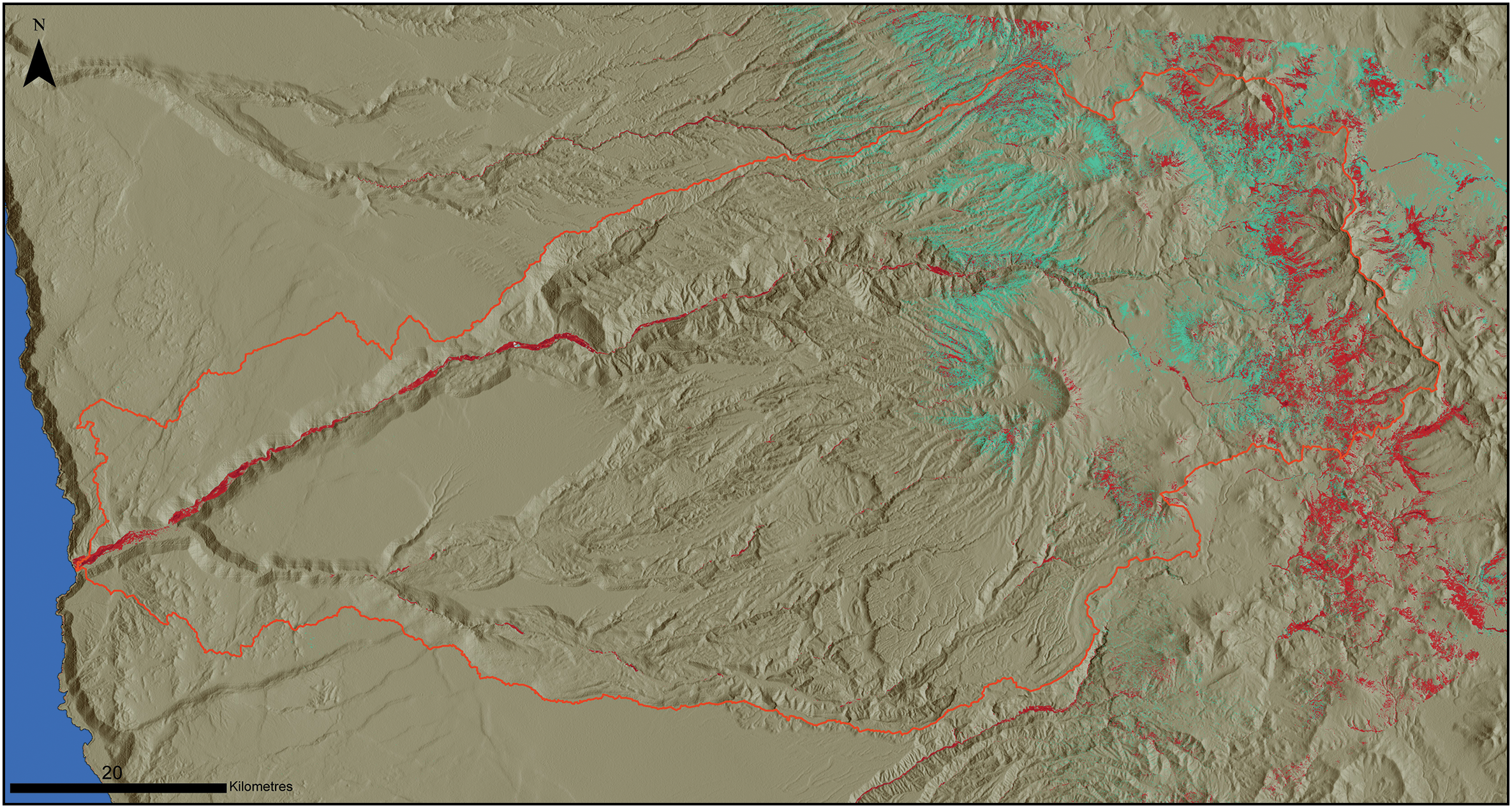
Despite the extreme aridity of the Atacama Desert, perennial and seasonal waters from the Puna provide essential hydration to the region. Seasonal monsoon rains cause natural fluctuations in the river’s flow, substantially impacting the distribution of flora and fauna in the Camarones basin and adjacent valleys, with amplified terrestrial biomass in the Puna (more than 3000masl) and rich marine resources by the Pacific Ocean (Figure 2).
Vegetation in the Camarones Basin during wet and dry seasons, based on above-ground vegetation analysis using the vegetational index MSAVI on 2018–2021 cumulative Sentinel-2 imagery (10m/pixel). Red indicates vegetation available in both the dry and wet seasons, while green indicates vegetation that is only available after the Andean rainy season (March–April) (figure by author).

Historical and cultural context
Archaeological evidence is not the only source of information for researchers aiming to interpret the emergence of increasingly complex societies in the Western Valleys after the Formative Period. Ethnohistory has played a crucial role in integrating chronicles and colonial documents with archaeological knowledge, particularly relevant for the eleventh century AD onwards. Yet the accounts of ethnic groups in colonial records are embedded within a context of exploitation under the Spanish Crown in the Americas. As such, the information they contain often reflects a logic driven by profit and extraction rather than by any neutral documentary intent, making it especially difficult to trace lower-status groups, such as the Uru, using colonial sources alone (Julien Reference Julien1987: 53). Much of the information recorded by Spanish colonists concerns ethnic groups of food producers that politically organised themselves in rank societies and chieftaincies (Nielsen 2006). Thus, the Late Intermediate and Late periods are nourished by information from highly hierarchical groups living under well-delineated socio-political regimes. As a result, the question arises as to whether the ethnic groups portrayed by the standard archaeological and ethnohistorical paradigms were the only ones encountered by Spanish settlers when they arrived in the Western Valleys. Fragmentary descriptions of people portrayed as maroon (cimarrones), poor, primitive and barbaric suggest that the ethnic tapestry was far more diverse than described by the archaeology of the late pre-Hispanic periods (Bouysse-Cassagne Reference Bouysse-Cassagne and Cook1975, Reference Bouysse-Cassagne1987; Julien Reference Julien1983; Bouysse-Cassagne & Harris Reference Bouysse-Cassagne, Harris, Bouysse-Cassagne, Harris and Platt1987; Wachtel Reference Wachtel2001). The most common name given to ethnic groups was Uru. The Uru, Uro or Huru have been defined in the colonial context as a specific tributary category (Julien Reference Julien1987; Bouysse-Cassagne Reference Bouysse-Cassagne1988: 76; Gil García Reference Gil García2013) that linguistically and economically generalises people who hunt, fish, who do not engage in farming and are particularly difficult to govern in the colonial system (e.g. de Matienzo Reference de Matienzo1967: 267). In the South-Central Andes, the Aymara, through their numerous chiefdoms, dominated the region and maintained close relations with the colonisers due to their territorial and productive power (Bouysse-Cassagne Reference Bouysse-Cassagne1987). Among the Pacaje, the dominant Aymara chiefdom in what is today the northernmost part of Chile, ethnohistorical accounts from the late nineteenth century indicate that hunters and fishers were held in low esteem, defined as “[a] nation of Indians despised by everybody, usually fishers, and of less understanding […] to one who walks dirty, ragged, rustic” (Bertonio Reference Bertonio1879: 380, author’s translation). This antipathy to populations understood today as foragers is upheld in the Andes with the Aymara concept chullpa puchu, which is used to refer to the Uru-Chipaya of the Coipasa salt flats and may be translated as ‘the scraps of the Chullpa’, a primitive society found before the time of the sun in the Aymara and Uru-Chipaya cosmogony (Wachtel Reference Wachtel2001: 15).
Despite the negative connotation of chullpa puchu, its meaning unfolds a path to trace colonial hunter-fisher-gatherer populations. In the current Aymara worldview, chullpa jaqui refers to ancestral people who play a role as souls that serve as mediators between the civilised society and the liminal world of wild forces (Bouysse-Cassagne & Harris Reference Bouysse-Cassagne, Harris, Bouysse-Cassagne, Harris and Platt1987: 40). Similarly, chullpa in the Aymara cosmogony forms part of the set of words linked to the Puruma or Purum pacha, a time before agriculture, before the sun with darkness only lessened by the moonlight, before the time of the sun and order (Bouysse-Cassagne & Harris Reference Bouysse-Cassagne, Harris, Bouysse-Cassagne, Harris and Platt1987: 23). One of the synonyms for Purum pacha in Aymara is chuquila or choquela. This multifaceted word, like chullpa, is associated with wild supernatural forces and cursed places, but was also used to refer to vicuña (Vicugna vicugna) hunters (Bouysse-Cassagne 1987: 89, Reference Bouysse-Cassagne1988: 36; Bouysse-Cassagne & Harris Reference Bouysse-Cassagne, Harris, Bouysse-Cassagne, Harris and Platt1987: 24; Wachtel Reference Wachtel2001: 23). Choquela has been linked with the natural force of lightning (Bouysse-Cassagne & Harris Reference Bouysse-Cassagne, Harris, Bouysse-Cassagne, Harris and Platt1987: 44), and in the Central Andes this word refers to a ritual dance that enacts the hunting of vicuñas using a trap with sticks and ropes (Gutierrez Reference Gutierrez1992), alluding to the funnel-shaped chacu traps.
Although choquela could be interpreted as a blanket term for hunters, research addressing the problem of foragers in the region during colonial times concedes that the Uru should be seen as ethnically separate from the Choquela, despite the conceptual overlaps they hold (Bouysse-Cassagne Reference Bouysse-Cassagne1987, Reference Bouysse-Cassagne1988; Bouysse-Cassagne & Harris Reference Bouysse-Cassagne, Harris, Bouysse-Cassagne, Harris and Platt1987; Wachtel Reference Wachtel2001). Such distinction is feasible given the sixteenth-century accounts by de Matienzo, which document that “[t]he others who call themselves chuquilas are hunters: there are few of these, and those who are they only understand how to kill feral cattle and worship. They are sorcerers, and … never see Spaniards” (de Matienzo Reference de Matienzo1967: 276, author’s translation).
Though chronicles such as de Matienzo’s describe a clear distinction between the Choquela and the Uru, the limited information available on these groups suggests that such differentiation applies only to Chucuito (a colonial province in Peru). Moreover, after the sixteenth century AD, the term Uru may have superseded Choquela, as the former was more generic and came to refer more broadly to foraging populations. The label appears to have been so inclusive that it was often used to denote linguistic categories (Bouysse-Cassagne Reference Bouysse-Cassagne1987: 47) or to describe people who paid specific forms of tribute related to hunting and fishing (Julien Reference Julien1987). Regardless of how these groups were distinguished, in the high-altitude areas where vicuñas live—between 3164 and 4857masl (González Reference González2020: 52)—there were historically foraging populations who specialised in hunting this camelid and other prey using the chacu funnel-shaped traps.
Geospatial analysis and remote sensing
The archaeological sites included in this study derive from three main sources: academic publications, grey literature and remote sensing. For the first two sources, co-ordinates were transferred to an ArcGIS Pro geodatabase, where each site was catalogued with relevant contextual information. In cases where geolocation was unavailable, place descriptions and toponyms were used, supplemented by site identification through freely accessible satellite imagery, primarily sourced from Google Earth and Bing. These images were integrated into a GIS environment within ArcGIS Pro using application programming interface keys.
A remote-sensing survey also made use of these freely available satellite imagery sources for a systematic search. A grid of 500 × 500m squares was deployed across the polygon representing the Camarones basin. This was used as a guide to systematically cover the entire study area, using a zoom level appropriate to the resolution of the available imagery. In 2018, the resolution spanned between 30 and 50cm/pixel. In these images, architectural features and large-scale or linear elements such as geoglyphs or pathways are typically the only structures visible. To ensure accurate identifications, known sites across all geomorphic floors of the Western Valleys were first examined using the imagery. This preliminary step served to familiarise the image interpreter with the appearance of archaeological sites in satellite imagery and to refine the criteria used for their identification (Snyder & Haas Reference Snyder and Haas2024).
Newly identified archaeological sites were initially recorded as points within the geodatabase, with an associated confidence level of low, medium or high. Preliminary information, including the type and estimated size of the site, was also documented. To ensure analytical rigour and minimise false positives, only records classified as having high confidence were included in further analyses. For the selected high-confidence records, additional data were examined, including the number of features per site and the geometry of any discernible structures.
Given the broad chronological range of the archaeological sites identified in the Camarones basin—spanning the entire pre-Hispanic sequence and extending into the colonial era—the range of sites observed is equally diverse. This diversity is further enhanced by the various sources of information consulted, which involve different identification techniques, including ground-level directed surveys, excavations and remote sensing (Oyaneder Reference Oyaneder2022). While this study is informed by an extensive bibliographic review, the new data presented here are derived exclusively from remote-sensing analysis.
Seasonal above-ground vegetation
Google Earth Engine was used to analyse the spatial distribution of above-ground vegetation in the Camarones Basin, based on Sentinel-2 satellite imagery from 2018 and 2021. These years were selected due to the availability of images with less than 10 per cent cloud cover that provided full coverage of the basin. The analysis focused on two key seasonal windows: the humid season following the summer rains (March–April) and the dry season (September–November). For both periods, the Modified Soil-Adjusted Vegetation Index (MSAVI) was calculated to estimate vegetation cover (Qi et al. Reference Qi, Chehbouni, Huete, Kerr and Sorooshian1994). MSAVI was selected over other commonly used vegetation indices due to the specific environmental characteristics of the study area. Above 2500masl, vegetation is predominantly shrubland within a semi-arid context, where extensive patches of bare soil are common. MSAVI is particularly suited to such conditions, as it mitigates distortions caused by exposed soils and high reflectance, reducing the likelihood of false vegetation readings (Zongfan et al. Reference Zongfan, Ling, Xuhai, Ming, Liangzhi, Huiqun and Jiaxin2022: 3). Seasonal variation in pasture coverage was identified by subtracting dry-season MSAVI values from those of the humid season (Figure 2). These differences were then analysed to assess whether seasonal variability in pasture availability potentially influenced the distribution of settlements and ungulate hunting traps. The resulting datasets were visualised and exported to ArcGIS Pro for further spatial analysis.
Distribution of evidence related to macro groups
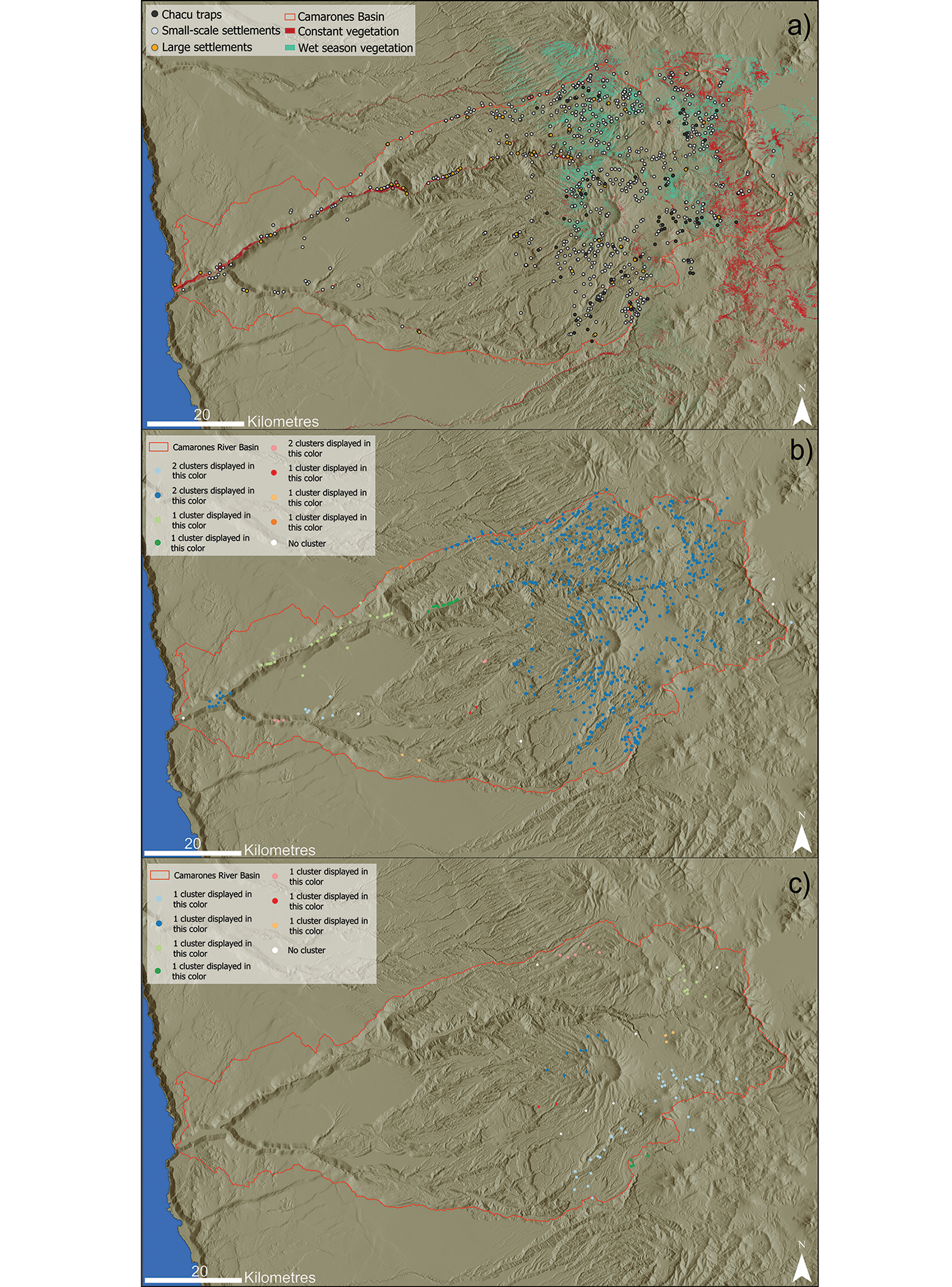
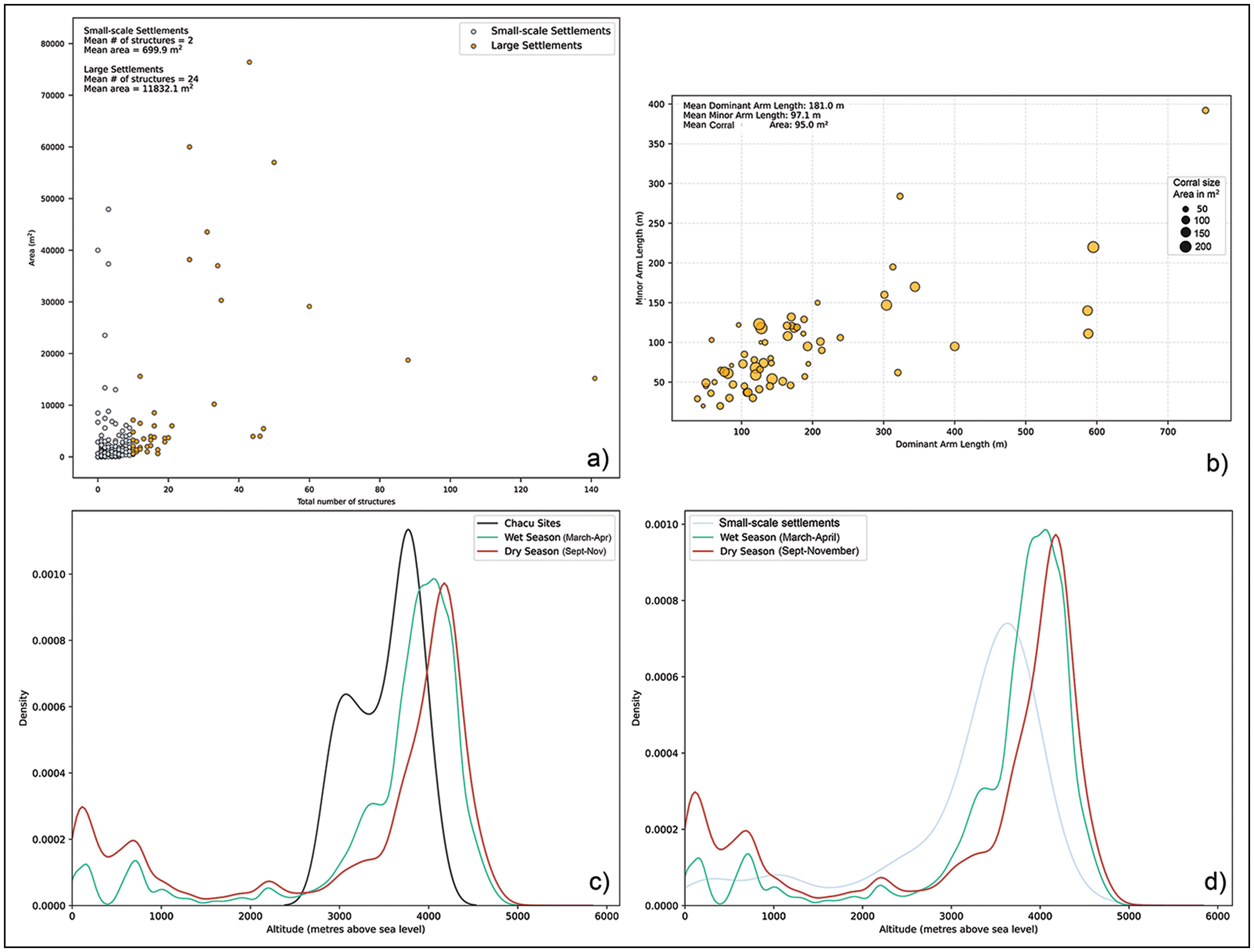
In total, 1622 archaeological sites were identified in the Camarones Basin. Of these, 12 per cent are from grey literature, 15 per cent from academic publications and 73 per cent from the remote-sensing approach. Within this diverse dataset, 790 records (49%) correspond to small-scale settlements, 58 (4%) to large settlements and 76 (5%) to hunting traps, the largest quantity of this latter category thus far identified in the Andes. Small- and large-scale settlements, as well as hunting traps, were analysed independently using the Density-Based Spatial Clustering of Applications with Noise (DBSCAN) tool in ArcGIS Pro. This tool identifies clusters based on a defined distance between points (Birant & Kut Reference Birant and Kut2007), which in this case was set at 5km (Figure 3).
a) Macro-groups and above-ground vegetation distribution during dry and humid seasons; b) DBSCAN analysis of small-scale settlements; c) DBSCAN analysis of chacu traps. Basemap: hillshade derived from ASTER DEM at 30m/pixel (figure by author).

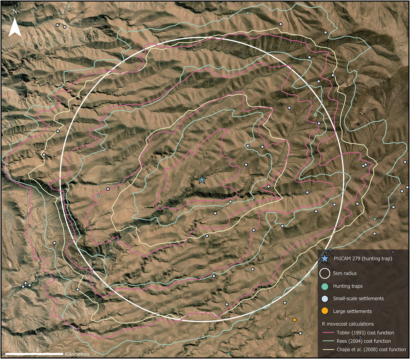
This defined distance, or epsilon, was established based on the estimated walking range over two to four hours of continuous movement without rest, within the area of highest site concentration, located between 2500 and 3800masl. A test point was defined from a hunting site at 3072masl, from which cost models based on slope were calculated to generate isochrones. These were created using the movecost R package (Alberti Reference Alberti2019), applied to a 30m/pixel ASTER DEM (advanced spaceborne thermal emission and reflection radiometer digital elevation model), incorporating Tobler’s (Reference Tobler1993) off-path hiking function, Rees’s (Reference Rees2004) slope-dependent cost function and the linear walking-time cost function (Chapa Brunet et al. Reference Chapa Brunet, García, Mayoral Herrera, Uriarte González, Bender, Evelpidou, Krek and Vassilopoulos2008). The resulting isochrones were imported into ArcGIS Pro to enable visualisation within the surrounding landscape (Figure 4), and a 5km-diameter buffer was established as a control element from the sampling point. Cost surfaces were calculated using a terrain factor of 1.67, based on conditions corresponding to bad trails and stony outcrops. Additionally, positive slope values were preliminarily multiplied by 1.99 and negative slope values by 2.31, in accordance with cognitive slope cost estimations (Pingel Reference Pingel2010). This adjustment reflects the rugged topography at these elevations, which includes ravines, abrupt drops, steep slopes and uneven terrain.
Projected 5km radius from central point at 3072masl, showing slope-dependent isochrones in one-hour intervals and the distribution of surrounding macro-group archaeological evidence (figure by author, basemap: Esri World Imagery).

Small-scale settlements
Small-scale settlements—clusters of up to nine standing structures and enclosures (Oyaneder Reference Oyaneder2022: 274)—are often viewed as ephemeral sites and thus marginal in studies of the Western Valleys. Recent research has begun to reposition them within broader socio-economic frameworks. In the Azapa Basin, satellite imagery revealed 560 archaeological sites, 64 per cent of which are small-scale and interpreted through pottery typology as part of Late Intermediate and Late period settlement systems (Saintenoy et al. Reference Saintenoy, Ajata, Romero and Sepúlveda2017). In the southern Atacama Desert and Salt Puna, the internodal approach has focused on sites situated between central nodes (Berenguer & Pimentel Reference Berenguer and Pimentel2017), with a particular emphasis on agropastoral socioeconomic structures. These sites correspond closely to the Andean concept of estancias: small, often seasonal settlements above 2500masl used by Uru-Chipaya and Aymara populations as pastoral outposts (Bouysse-Cassagne Reference Bouysse-Cassagne1987: 210; Wachtel Reference Wachtel2001: 68).
In the Camarones Basin, many small-scale sites remain undated due to the lack of excavations (Figure 5). Surface collections at 10 locations have yielded a Middle Archaic projectile point (6000–4000 BC) alongside Late Intermediate, Late and colonial-period decorated pottery (García & Ajata Reference García and Ajata2016; Oyaneder Reference Oyaneder2022). Local muleteers identify several sites, particularly those in the upper reaches of the basin, as majadas—seasonal pastoral residences occupied after the summer rains, typically between March and April, to take advantage of newly sprouted pasture (García & Ajata Reference García and Ajata2016: 240).
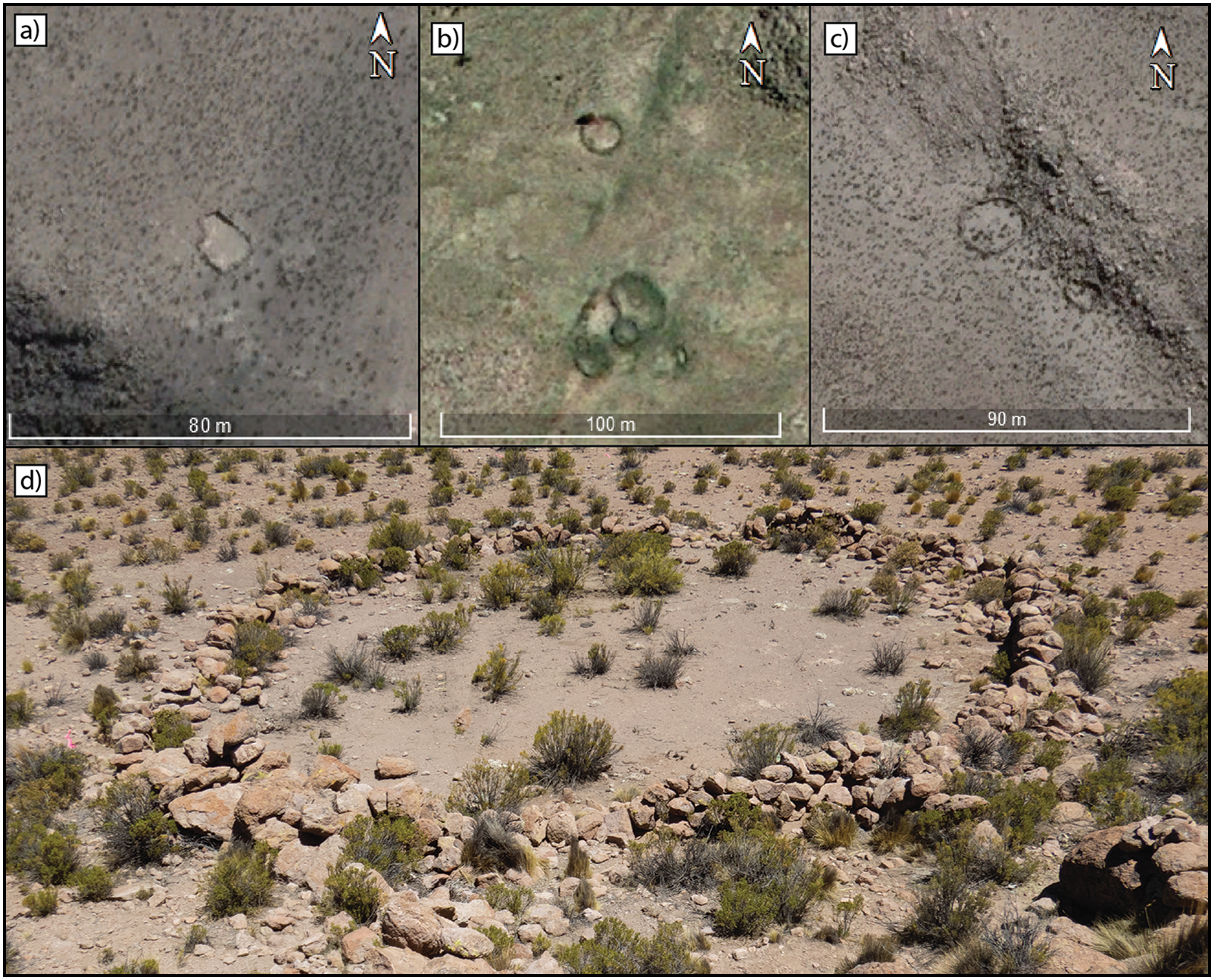
Small-scale settlements in the Camarones Basin: a) PhICAM 947; b) PhICAM 1414; c & d) PhICAM 1287 (figure by author, basemap: Google Earth Pro).

The distribution of small-scale architectural sites in Camarones and their correlation with seasonal changes in vegetation cover indicate a marked preference for upland zones, where low-scale stone-wall constructions are concentrated (Figure 6d). This pattern intersects with the location of chacu, which, while often overlapping with small-scale sites, are more densely distributed below 4000masl. All upland small-scale settlements fall within a single cluster under a 5km epsilon, suggesting a coherent, tethered settlement pattern oriented towards hunting.
These features suggest a landscape that reflects an accumulation of occupations over time, possibly within a broad temporal range. Moreover, the extended yet not concentrated distribution is indicative of highly mobile populations, potentially shared by culturally distinct groups. Although camelid herding is yet to be confirmed, the presence of traps and their territorial alignment with vicuña, guanaco (Lama guanicoe) and taruca (Hippocamelus antisensis) habitats support an interpretation of sustained ungulate hunting.
Hunting traps
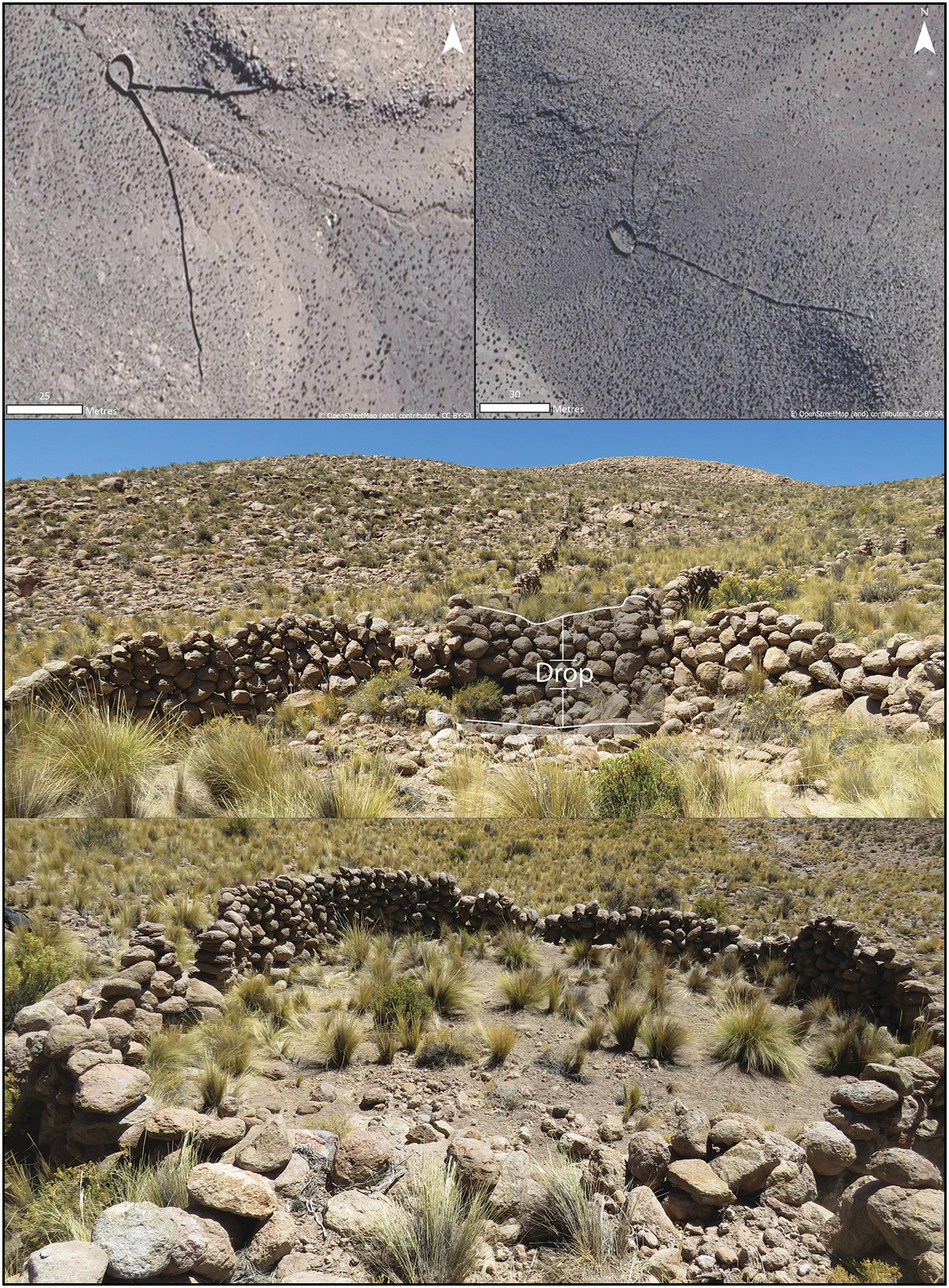
The chacu are large installations, interpreted as traps for collectively hunting wild ungulates, consisting of funnel-shaped dry-stone walls laid out on slopes with gullies. In Camarones, 76 hunting structures were identified through a satellite imagery-based survey (Oyaneder Reference Oyaneder2022). However, a study on desert kites (another term for funnel-shaped hunting traps) on a global scale was published in parallel, reporting 102 traps in an area covering part of the Camarones Basin and other basins to the south and east (Barge et al. Reference Barge, Wazizeh, Brochier, Crassard, Régagnon and Noûs2020). These results confirm a parallelism with other arid regions of the world, where the use of funnel-shaped traps to hunt ungulates has also been documented. These traps characteristically establish vertical drops between the antennae of the trap and the enclosure.
Across the Andes, chacu traps have received limited archaeological attention, and there is little information available from excavations and surveys (Aguilar Meza Reference Aguilar Meza2018; Barnes Reference Barnes2024). As a result, the chronology of their use is uncertain. Nonetheless, colonial accounts broadly agree that chacu were employed by the Inka during the Late Period and their use continued into colonial times (Yacobaccio Reference Yacobaccio and Gordon2009). Rock art offers a complementary perspective; hunting scenes involving chacu depicted in the naturalistic style date to as early as 4000 BC, with later examples from the Formative Period (Dudognon & Sepúlveda Reference Dudognon and Sepúlveda2018). Anthropology and ethnohistory further enrich archaeological interpretations by linking these traps to hunting groups such as the Chacu haque (Bertonio Reference Bertonio1879: 68) and identifying the Choquela as key operators of chacu in vicuña capture (Millones & Schaedel Reference Millones and Schaedel1980; Cuentas Reference Cuentas1982).
The trapping function of these sites is reinforced by the distribution of chacu identified in the Camarones Basin (Figures 6 & 7). The presence of chacu between 2800 and 4200masl closely aligns with the natural habitat of vicuña, guanaco and Andean deer. In other arid regions of the world, traps with comparable morphological features—specifically long antennae converging into enclosures—have primarily been used to capture fast and elusive animals such as gazelles using roundup techniques (Crassard et al. Reference Crassard, Abu-Azizeh, Barge, Brochier, Chahoud and Régagnon2022). The herding behaviour of the fleet-footed Andean ungulates likewise makes trapping an effective hunting strategy for this prey, supporting the interpretation of chacu as hunting installations.
a) Scatter plot of total structures and site area, distinguishing small-scale (≤9 structures) from large (≥10 structures) settlements; b) chacu arm lengths (dominant/secondary), with circles sized by area of end corral; c) kernel density plot of altitude distributions for chacu sites (black), with modelled wet (green) and dry (red) seasons; d) equivalent kernel density plot for small-scale settlements (blue) (figure by author).

Examples of chacu traps found in the Camarones Basin. Note the drop found in the trap shown in the middle (figure by author).

In terms of construction, the chacu in the Camarones Basin display a high degree of consistency: 90 per cent comprise two antennae and a final enclosure, while the remaining examples include variations with up to four antennae, double enclosures or open-ended forms lacking a final corral. Notably, these traps are consistently located on steep slopes, often positioned over gullies or small watercourses running through the centre of the structure. Each trap typically features one dominant and one secondary antenna (Figure 6b), averaging 181m and 71m in length, respectively. The final enclosures vary in shape—circular, quadrangular or irregular—largely following the terrain rather than a standardised plan, with an average area of 95m2.
Tethered settlement pattern in the highlands
The chacu and small-scale settlements described above suggest that a range of human groups occupied this landscape from at least 6000 BC to AD 1700. These groups moved strategically across the highlands, tethered primarily to hunting resources, particularly vicuña. The evidence indicates overlapping lifeways, combining hunting-gathering with, possibly, pastoralist-hunting practices. Foragers specialising in vicuña capture and mobile pastoralist-hunters may have been contemporaneous at times, likely requiring negotiated access to shared hunting territories. Such arrangements may have resembled the collective management of wild animals by ranching communities, involving the division of herds among family groups (e.g. Ingold Reference Ingold2007). Within this framework, some small-scale settlements in Camarones may have served as ranch-like outposts embedded in a tethered landscape of seasonal mobility.
It is therefore plausible that during the Late Intermediate and Late periods, and into the colonial period, Aymara curacas (chiefs) engaged in a form of vicuña ranching or claimed territorial control over specific hunting zones through ranching vicuña (e.g. Yacobaccio Reference Yacobaccio and Gordon2009). Simultaneously, other groups may have operated within the same landscape, actively hunting in areas overseen by curacas. The clustered yet broad distribution of small-scale settlements across the highlands strengthens this interpretation. Additionally, the seasonal variability in vegetation cover would have supported both domestic herds and wild ungulates, reinforcing the dual economic use of these highland spaces as tethered landscapes structured by both ecological and social logics.
Conclusions
This research represents an initial step toward bridging the gap between archaeological and historical evidence for hunting and highly mobile groups in the highlands of the Western Valleys of northern Chile. Through comprehensive territorial coverage and the decision to record all features visible in satellite imagery without prior classification, a substantial number of small-scale settlements and chacu have been identified in the highlands of the Western Valleys. These findings link archaeological and (ethno)historical evidence for hunting and highly mobile highland groups, suggesting persistent mobility and strategic tethering to hunting resources across millennia. With the presence of such sites established, the foundations are now laid for further research into the chronology of their use and the diverse lifeways that co-inhabited and exploited the highland landscapes of the Western Valleys and the South-Central Andes.
Acknowledgements
I am sincerely grateful to the communities of Cuya, Caleta Camarones and Parcohaylla for their generosity during fieldwork, and especially to Nelly Biza and her family for welcoming me into their home and facilitating visits to local sites.
Funding statement
The Chilean National Research and Development Agency (ANID) funded this research through its Becas Chile doctoral scholarship grant 72170657 and the National Fund for Scientific and Technological Development (FONDECYT) Project 1201687.

 Open access