


Introduction
Archaeologists have long been interested in understanding the impact major natural disasters had on past cultural trajectories (e.g. Torrence & Grattan Reference Torrence and Grattan2002; Jaffe & Hein Reference Jaffe and Hein2020; Riede et al. Reference Riede2020). Traditionally, external shocks have been viewed as triggers for collapse and the disappearance of entire cultures. More recently, interest has shifted towards exploring persistence, survival and recovery in terms of resilience. Volcanic eruptions are a particular type of natural disaster. Classic work on their impact has tended to focus on the demise of agricultural societies and urban civilisations. Newer studies dedicated to ‘palaeo-societal volcanology’ have explored how smaller-scale foraging societies responded to volcanic events (Riede Reference Riede2014, Reference Riede2015, Reference Riede2016; Barnes & Soda Reference Barnes and Soda2019). In all cases, the key issue is the extent to which societies exhibit internal capacity to absorb shocks and to continue along the same developmental trajectory (cf. Torrence Reference Torrence2019; Riede et al. Reference Riede2020).
Our article adds to these debates by reconstructing the impact of the Kikai-Akahoya (hereafter, K-Ah) ‘super-eruption’ dated to 7.3ka cal BP—one of the largest volcanic events of the Holocene—on Jōmon forager communities in south-western Japan (Machida & Sugiyama Reference Machida, Sugiyama, Torrence and Grattan2002). We showcase the rich archaeological record available and highlight long-term research by Japanese archaeologists into the effect of volcanic activity on human history.
Here, we focus attention on Tanegashima Island, which was devastated by K-Ah but was eventually resettled by surviving communities from neighbouring regions (Figure 1), and deploy a multi-proxy approach to reconstruct: (a) lifeways prior to the eruption; (b) the impact and legacy of the disaster; and (c) the strategies used by the groups who reoccupied the damaged ecosystems. The resulting insights suggest that neither ‘collapse’ nor ‘resilience’ fully capture the complex dynamics of this process and that we need to delve deeper to better understand the multi-scalar impacts and legacies of natural disasters on particular cultural trajectories.
a) Thickness of K-Ah tephra layers across Japan; b) detail of K-Ah tephra thickness across Kyushu and location of Tanegashima (figure by J. Uchiyama: a) adapted from Machida & Arai Reference Machida and Arai2003: fig. 2.1-2, with permission from University of Tokyo Press; b) summarised from Kuwahata Reference Kuwahata2016 & Naruo Reference Naruo2021).

The K-Ah disaster: population replacement versus continuity?
The Jōmon foraging communities of southern Kyushu thrived in the rich ecosystems of the Holocene Climatic Optimum (Figure 2). This situation changed, however, at 7.3ka cal BP, with the massive caldera-forming K-Ah ‘super-eruption’. This event had a Volcanic Explosivity Index (VEI) of 7, making it one of the top ten most powerful eruptions of the Holocene. The epicentre was located in the ocean floor, approximately 35km off the southern tip of Kyushu Island (see Figure 1b). K-Ah ejected more than 100km3 of tephra, which rained down over an area of approximately two million km2 of North-east Asia (Figure 1a) (Ui Reference Ui1973; Machida & Arai Reference Machida and Arai2003).
Correlation between global temperature trends (top; after Stuiver & Grootes Reference Stuiver and Grootes2000), pottery traditions in southern Kyushu (middle), occupation phases of Sanakuyama (light green bars), and Jōmon chronology (bottom) (figure by J. Uchiyama. Occupation phases of Sankakuyama are based on Kagoshima Prefectural Archaeological Centre 2006; Jōmon chronology based on Kobayashi Reference Kobayashi2019. Pottery images are reproduced with permissions (for details, see the online supplementary material)).

Archaeologists in Japan make widespread use of tephras to define chronozones (Riede et al. Reference Riede2020). For many years, it was assumed that the thick K-Ah ash layers must have extinguished all life across Kyushu, causing a major cultural break, with new groups eventually moving back into the area from distant refugia. This ‘demographic replacement model’ was supported by earlier interpretations of pottery typologies. Importantly, the major Jōmon-period Hiragakoi-Senokan pottery tradition was thought to end abruptly immediately beneath the K-Ah tephra layer, while the new Todoroki tradition first emerged in deposits directly above it (Shintō Reference Shintō1980; Kizaki Reference Kizaki and Kenkyukai1985).
Recently, this model has been revised and largely replaced. Careful re-analysis of the same pottery traditions across a wider range of sites now confirms significant cultural (and hence population) continuity, even in areas of southern Kyushu located relatively close to the eruption's epicentre (Kuwahata Reference Kuwahata2016). Specifically, the Hiragakoi-Senokan tradition had already ended well before K-Ah, and the Todoroki tradition had commenced prior to the eruption, persisting from c. 7700 cal BP, through the K-Ah event, and ending c. 6300 cal BP (Figure 2). The Todoroki pottery groups can further be divided into several sub-traditions. Importantly, it is now clear that the Todoroki A sub-tradition, which was distributed widely across Kyushu, and especially the Nishinosono sub-tradition (c. 7350–7050 cal BP), must have been maintained by ‘survivors’ of the K-Ah event. These traditions are followed by the descendent sub-traditions, Todoroki B1, B2 and B3.
Closer analysis of these high-resolution pottery sequences also indicates that the severity of the impact of K-Ah was spatially zoned. First, the disaster created a ‘dead zone’ surrounding the ‘ground zero’ epicentre. This zone, including the Tanegashima and Yakushima Islands plus coastal regions of southern Kyushu (Kuwahata Reference Kuwahata2016, Reference Kuwahata2020) (Figure 3), was severely affected by the K-Ah Kōya pyroclastic flow (K-Ky) and has yielded no examples of Nishinosono ‘survivor’ pottery. Second, beyond the ‘dead zone’ was a ‘partial survival’ zone, defined by the persistence of local pottery traditions, pointing to some degree of demographic continuity, despite heavy ash falls. Areas beyond this second zone had higher levels of survival, although disruptions from K-Ah may have been substantial. Over time, the survivors found ways to adapt to the new conditions and eventually rebounded. These surviving groups formed the source populations for the eventual resettlement of the southern coasts and the devastated offshore islands of the ‘dead zone’. Our goal here is to understand the impact of K-Ah on Tanegashima Island and to investigate how people from neighbouring communities adapted to and survived in the new environment.
Distribution of (a) Todoroki A and (b) Nishinosono pottery types in Kyushu. The locations of sites that have yielded relevant phytoliths samples and related Ikeda Caldera tephra chronozone are marked in green (see Figure 4) (figure by J. Uchiyama, adapted from Kuwahata Reference Kuwahata2020: fig. 4, with permission).

Context, materials and methods
Located just 50km from the K-Ah epicentre, Tanegashima Island covers some 450km2 and is dominated by rolling hills, which rise to 282m asl. Today, a compacted tephra layer approximately 0.20–1m deep blankets the island. The K-Ky pyroclastic flow deposits are concentrated in southern areas (Figure 1b). Over 200 Jōmon sites confirm human occupation before and after K-Ah (Kowaki Reference Kowaki2019), offering the opportunity to investigate human and environmental responses to the disaster. While there are few deeply stratified sites, the hilltop Sankakuyama archaeological complex (see below) provides evidence of long-term developments in one location (Figure 2).
To develop a multi-proxy approach, we have assembled published excavation reports pertaining to archaeological sites, artefact assemblages and palaeoenvironmental records before and after K-Ah. This dataset offers a diverse set of proxies, which are used to infer palaeoecological changes and to detect shifts in settlement patterns, tool use and subsistence practices before and after the disaster. We also conduct organic residue analysis on ceramic cooking pots from the stratified Sankakuyama complex to investigate long-term patterns in food-processing traditions. Full descriptions of the datasets, methods and analytical procedures are provided in the online supplementary material (OSM).
Results
How did K-Ah affect Tanegashima's vegetation? Previously, researchers have used phytolith records from natural sediments to explore the regional-scale impact of the eruption on vegetation cover (Sugiyama Reference Sugiyama1999). Although these researchers have collected samples from more than 100 locations, only four of these sites report quantification of plant species (see the OSM). Of these, two are relevant for understanding the localised impact of K-Ah on Tanegasima (Figure 3b). First, at the Shimama site on Tanegashima Island (Location 4), two samples were retrieved from directly above the K-Ah tephra, but are not directly dated. Second, at the site of Atsugase on Kyushu (Location 20), three samples were taken from sedimentary layers located above the K-Ah (7.3ka) tephra and below the more localised Ikeda Caldera (6.6ka) tephra, providing tighter chronological control. While Atsugase is located in southern Kyushu, we tentatively assume that the impact on vegetation was similar to that on Tanegashima, given its comparable distance to the K-Ah epicentre and location within the area affected by the K-Ky pyroclastic flow (Figure 3).
Phytolith records from these two locations confirm major shifts in vegetation following K-Ah. Specifically, the lucidophyllous (evergreen broad-leaved) forest that had once dominated the warm temperate landscape was destroyed (Figure 4). This vegetation was slowly replaced by patchy grassland within a mosaic of exposed ash-fields (Sugiyama Reference Sugiyama1999). While the samples taken from above the K-Ah tephra on Tanegashima are undated (Figure 4a), the samples from southern Kyushu (Figure 4b) suggest that this impoverished vegetation dominated throughout the Todoroki B1-3 pottery period (c. 7100–6600 cal BP), indicating that the impact on vegetation persisted for a period of at least seven centuries following K-Ah. Although further investigations are required, these initial insights align well with reconstructed vegetational sequences that have followed other recent eruptions, including Mount St Helens in 1980 in the Pacific Northwest (Dale et al. Reference Dale, Swanson and Crisafulli2005) and Miyake Island in 2000, 180km south of Tokyo (Kamijō et al. Reference Kamijō2016), as well as the long-term development of mire vegetation at Utasai Bog in Hokkaido over the past 3000 years, containing tenth-century BC tephras of the Baitoushan eruption in the north of the Korean Peninsula, plus several seventeenth-century volcanic eruptions in southern Hokkaido (Hughes et al. Reference Hughes2013).
The impact of K-Ah on regional-scale vegetation cover: (a) Shimama, Minamitane town (Tanegashima Island); (b) Atsugase, Kinkō town (southern Kyushu). For sampling locations, see Figure 3b, and for further details, see the online supplementary material (figure by J. Uchiyama, data summarised from Sugiyama Reference Sugiyama1999).

How was human settlement affected by K-Ah, and did those who reoccupied Tanegashima inhabit the devastated island landscape in different ways to their predecessors? Our analysis of site location data (Kowaki Reference Kowaki2019) highlights several important trends (Figure 5a & b). First, settlement patterns were dynamic prior to the disaster, possibly indicating population growth. Indeed, there was a sharp increase in site numbers after 9000 cal BP (i.e. across the Oshigatamon, Hiragakoi-Senokan and early Todoroki pottery traditions of the Initial phase; see Figure 2 and the OSM). Second, the disaster put an end to this trend. Tanegashima clearly falls within the ‘dead zone’, and no sites have been recorded immediately above the K-Ah tephra. Furthermore, the complete absence of Nishinosono ‘survivor’ pottery (c. 7350–7050 cal BP) points to an occupation hiatus of several centuries. Third, the earliest human reoccupation is evidenced by the appearance of Todoroki B1 sherds (c. 7100–6900 cal BP) at the Tosa site, which is a small settlement located on a riverhead terrace in southern Tanegashima (Figure 5c) (Nakatane Town Board of Education 2005). Fourth, all the post-hiatus sites, which are associated with the Todoroki B1-3 pottery tradition, appear to be smaller and more ephemeral, with fewer features and limited assemblages than those that predate K-Ah (Table 1); this may indicate the presence of smaller and more mobile populations. Fifth, this newly established pattern persisted until the Sobata period (c. 6300–5500 cal BP), which appears to witness a gradual recovery in site numbers and overall population levels (Figure 5d), although these sites still tend to be relatively small (Table 1). Overall, our analysis suggests that the immediate impact of K-Ah was abrupt and that the effects persisted long after the eventual resettlement of the island.
a–c) Location of Jōmon sites on Tanegashima Island by phase. The grey spread on (c) refers to the area covered by the K-Ky pyroclastic flow (figure by J. Uchiyama, based on Kowaki Reference Kowaki2019).

Overview of archaeological features on Tanegashima Island. The K-Ah eruption occurred at the end of the Initial phase.

To understand better these shifts in ‘landscape choices’, we conducted a qualitative assessment of the ways in which Tanegashima Island was occupied following K-Ah. The island consists of several discrete topographical zones, each offering different opportunities for settlement and subsistence. The interior uplands are drained by numerous fast-flowing rivers, which carve deep valleys with poorly developed fluvial terraces, eventually forming large sandy estuaries as they enter the sea (Nakata Reference Nakata1968). Using archaeological site location surveys (Kowaki Reference Kowaki2019) to identify changing patterns of land use, we define four location types: Jōmon sites located on rounded hilltops at the heads of rivers (type A) or on hillslope shoulders between rivers (type B), all either higher than 100m asl or at least 2km from the coast; sites situated along marine terraces (type C); and sites in the coastal lowlands close to the mouths of rivers (type D), all lower than 100m asl and within 2km of the ocean (Figure 6a). A comparison of occupation patterns before and after K-Ah suggests general shifts in settlement. Prior to K-Ah, the use of inland areas appears to increase from the Incipient (c. 14 100–11 400 cal BP) through to the Initial Jōmon (c. 11 400–7100 cal BP) periods, when inland locations dominate the overall settlement pattern. In contrast, the relative proportion of sites in these inland zones (types A and B) decreases after K-Ah. This may indicate that the coastlines were used more intensively, while inland zones may have suffered longer-term damage to vegetation and an initial lack of game animals (Figure 6b).
a) Schematic model of main ecozones on Tanegashima Island; (b) sites plotted per period into these ecozones (figure by J. Uchiyama).

To what extent did these shifts in settlement correlate with wider changes in subsistence before and after K-Ah? While faunal and botanical remains are poorly preserved in Tanegashima's acidic soils, numerous artefact assemblages (see the OSM) have been recovered and systematically documented during extensive fieldwork, providing useful proxies for general shifts in subsistence. Here, we explore spatio-temporal patterns in subsistence-related tool types and how their variability at coastal and inland sites changed in the periods before and after K-Ah.
Our analysis of tool-kit diversity examined changing frequencies of arrowheads, grinding stones and saddle-querns. The starting assumption was that the arrowheads were probably associated with hunting and that grinding stones and querns were likely related to plant processing; adzes may have been used for felling and working timber. The results reveal several patterns. The relatively high numbers of arrowheads at inland sites pre-dating K-Ah (Figure 7a) suggest that terrestrial hunting was significant, whereas this pattern shifts dramatically after people returned to the island; arrowheads virtually disappear at inland sites (Figure 7b & c). Further, the overall number of arrowheads remains low throughout the rest of the post-K-Ah sequence. While noting that multiple factors may account for this pattern (see the OSM), the most parsimonious interpretation is that hunting formed an important part of subsistence prior to K-Ah but played a much smaller role after groups returned to Tanegashima.
Changing composition of Jōmon tool kits on Tanegashima Island: a) Initial phase; b & c) Early phases (see Table S2 in the online supplementary material) (figure by J. Uchiyama).

The analysis of grinding stones and saddle-querns offers further insights. Across all periods, these heavier tools remained in widespread use on Tanegashima at both coastal and inland sites, and even became the most frequent tools after the occupation hiatus (Figure 7b & c). While these stones could have been used for diverse purposes (Adams Reference Adams2002; Kamijō Reference Kamijō2015: 405–22; Yasui Reference Yasui2021), use-wear studies from adjacent areas of Japan associate them with plant processing, including pounding and grinding to extract starch and remove tannins (Kamijō Reference Kamijō2015: 279–404). Indeed, from the Initial to the Early Jōmon period, distinctive kinds of grinding stones and saddle-querns are standard equipment for acorn processing across Kyushu (Kamijō Reference Kamijō2015: 294–99 & 362–71). Initial visual examination of the grinding stones from Tanegashima, however, suggests that their size and weight may have shifted after the reoccupation of the island (see Table S2 and Figure S3). Grinding stones recovered from inland and coastal sites pre-dating K-Ah have broadly similar weights, with most examples falling within the 200–600g categories. Across Japan, this distinctive range of weights is explicitly associated with acorn (Quercus sp.) processing and subsistence practices that extend back to the Upper Palaeolithic (Kurotsubo Reference Kurotsubo1983 & 1984; Suzuki & Kurotsubo Reference Suzuki and Kurotsubo2000) (Figure S3e). In contrast, the groups who returned after K-Ah used smaller and lighter stones with weights less than 200g (Figures S3c & d). Again, this change may be explained by multiple factors (see the OSM), but it is likely that different types of resources were exploited following K-Ah, as specific types of stones are typically used to process particular plant or nut types (Fullagar et al. Reference Fullagar2012; Kamijō Reference Kamijō2015: 405–22). Potential candidates include starch-rich stems or tubers, including kudzu (Japanese arrowroot, Pueraria montana) and Japanese sago palm (Cycas revoluta) (cf. Thierret Reference Thierret1958; Nomoto Reference Nomoto2020).
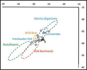
Did cooking traditions also change after K-Ah? To address this issue, we conducted organic residue analysis of ceramic cooking pots from the stratified Sankakuyama complex (Figure 8). We sampled sherds from contexts pre-dating K-Ah (Layers III and V) and a context following the return of groups to the island (Layer IIa). In total, 26 sherds were analysed (see the OSM). The results indicate that the processing of aquatic resources dominates vessel function across all occupation phases, while there is no evidence that the vessels were used to process plant resources or terrestrial game. This use of pottery primarily for the processing of aquatic resources appears to form part of a wider Jōmon phenomenon noted across Japan, with other foods such as nuts and game probably cooked in different ways (Robson et al. Reference Robson2020). Following K-Ah, pottery from Tanegashima was still used to process brackish and freshwater fish, but there is no evidence for the continued cooking of marine resources (Figure 9a & b). These shifts in culinary practices may correlate with wider changes to subsistence after K-Ah, with brackish water species such as Asian hard clam (Meretrix lusoria) and shellfish (e.g. fam. Ocypodidae) dominating faunal assemblages at the Ichijin-Nagasakibana shell midden (Figure 5c; Minamitane Town Board of Education 2016).
a) Location of the Sankakuyama complex; b) stratigraphy of Sankakuyama I and association with vegetation from phytolith analysis (figure by J. Uchiyama, information from Kagoshima Prefectural Archaeological Centre 2006).

Organic residue analysis of cooking pots: a) before K-Ah and (b) after eventual reoccupation of the island. Two samples in (a) are from Sankakuyama II (triangles). All other samples come from Sankakuyama I (diamonds). Filled symbols indicate molecular evidence for processing aquatic products. The δ13C-values are derived from C16:0 and C18:0 fatty acids, with the 95% confidence ellipses based on modern Japanese reference samples (Lucquin et al. Reference Lucquin2018) (see Table S3 in the online supplementary material) (figure by S. Isaksson).

Discussion: limited options in a damaged ecosystem?
Our multi-proxy approach has reconstructed subsistence practices on Tanegashima prior to the K-Ah disaster and sought to understand how communities re-established themselves on the island following the eruption. We propose the following tentative synthesis. Before K-Ah, the forested island supported a thriving Jōmon population who occupied coastal and inland sites and practised broad-based subsistence strategies involving nut processing and terrestrial hunting, along with riverine and coastal fishing. The combined K-Ah eruption and K-Ky pyroclastic flow devastated the island, stripping away forest and annihilating human and game populations. The terrain was blanketed under a thick and unstable ash layer, which probably choked the island's rivers. The local vegetation slowly recovered, but the island's remote location inhibited recolonisation by game animals. At this stage, the island could appropriately be described as a wasteland, remaining devoid of human populations for centuries.
Jōmon populations across southern Kyushu were heavily impacted by the eruption, but some survivors eventually found ways to adapt to the new conditions. After some centuries, groups ventured back to Tanegashima, finding a badly damaged environment. Coastal and estuarine ecosystems may have recovered more quickly (cf. Carrillo & Díaz-Villanueva Reference Carrillo and Díaz-Villanueva2021), but inland vegetation was probably restricted to patchy grassland. Opportunities for terrestrial hunting were severely limited. Plant foods were available, but the absence of forest cover steered subsistence practices towards the exploitation of nitrogen-fixing pioneer species, such as the starchy kudzu or Japanese sago palm (cf. Fagan & Bishop Reference Fagan and Bishop2000; Forseth & Innis Reference Forseth and Innis2004). The settlers returned with their pottery-based cooking traditions but focused on a narrower range of fish species acquired from brackish rivers and estuaries.
Overall, differences in inland versus coastal ecosystem recovery rates suggest that returning groups largely focused their activities along the shorelines. Post-K-Ah population levels remained low. This precarious new lifestyle persisted until at least 5500 cal BP, suggesting that the K-Ah disaster left a legacy which persisted for almost two millennia.
One major question emerging from this account concerns how terrestrial hunting could have resumed following K-Ah. One arrowhead is found in the earliest post-hiatus occupation layer at the Tosa site (Todoroki B1 phase). The first direct faunal evidence, however, appears later, during the Todoroki B2 phase of the Ichijin-Nagasakibana shell midden, and consists of only of one wild boar (Sus scrofa) maxilla and one sika deer (Cervus nippon) cervical vertebra (identifications by JU) in an assemblage otherwise dominated by fish, shellfish and other unidentified faunal remains. It is possible that game populations somehow survived K-Ah and were then exploited when groups returned, or that these small bone fragments represent cuts of meat or other supplies brought over from Kyushu.
A third and more intriguing possibility is that the settlers actively ‘re-stocked’ the damaged island with small and ‘portable’ animals such as sika deer and boar, either as part of the initial return following K-Ah, or after they had established themselves more permanently. Any such restocking may also have included transporting suites of wild plants that could be reliably harvested in the damaged post-volcanic landscapes. Such new forms of ‘traditional ecological knowledge’ may have been evolving across southern Kyushu as part of the wider cultural recovery following K-Ah.
Conclusions
Our article seeks to move away from the lingering assumption that natural disasters inevitably trigger ‘collapse’ and the disappearance of entire cultures. Instead, we contend that further empirical work is required to examine a more complex cycle of catastrophic impact, initial recovery and the deeper transformation of particular cultural trajectories. In addressing these questions, Japan offers some of the highest-resolution archaeological sequences in the world, with fresh work now being undertaken as part of a new Nordic-Japanese research programme in Disaster Studies (Jordan et al. Reference Jordan2021).
The main goal in the current contribution has been to explore the role of one remote island within the wider regional disaster triggered by the K-Ah volcanic eruption. Before K-Ah, a thriving Jōmon population occupied coastal and inland sites on Tanegashima and had a broad-based subsistence based on nut processing, terrestrial hunting and fishing. The K-Ah eruption devastated the island, leaving a wasteland with neither human nor game populations. Some regional survivors, however, eventually found ways to adapt, venturing back to a damaged environment on Tanegashima after some centuries. Limited game and plant foods were available, and subsistence was orientated towards the exploitation of starchy kudzu or Japanese sago palm, as well as brackish river and estuarine resources. These returning groups largely focused on the shorelines, with population levels remaining low until at least 5500 cal BP, suggesting that the K-Ah disaster had a long-term impact on human occupation of the island.
Many issues concerning this re-occupation need further resolution. First, more island-wide phytolith studies should be conducted to examine the relationship between reforestation and human land use in coastal and inland zones. Second, use-wear and starch-grain analysis (cf. Shibutani Reference Shibutani2017) of grinding stones and other tools is needed to refine our understanding of subsistence trends. Third, more work is required to compare and contrast the character of coastal adaptations before and after the disaster, especially as these areas appear to have been the focus of the new communities that eventually re-established on the island. Fourth, targeted palaeogenomic investigation of terrestrial game and other potential plant and animal indicator species could help illuminate the biogeography of the island's taxa, which first became isolated from Kyushu after postglacial sea level rises. This would shed light on the extent to which particular animal populations either survived K-Ah in situ or were re-stocked by settlers after K-Ah. If the latter, then Tanegashima provides a convincing example of the sophisticated ways in which prehistoric foragers understood and actively managed their ecosystems, including transporting key food resources to new locations.
Our case-study also has broader potential significance for understanding human responses to disasters, though it is premature to condense our emerging understanding into simplistic post hoc narratives of ‘resilience’. The dynamics of the Tanegashima resettlement confirm the importance of a multi-scalar approach that examines the impact of the K-Ah catastrophe on the original population, and the potential survival and recovery rates across a nested set of zones that extend outwards into Kyushu and beyond. Analysis of a much wider suite of cultural, ecological and biological proxies across the extensive horizon of the K-Ah disaster could be targeted to explore how some communities survived, adjusting their lifeways and traditions within southern Kyushu, and only then reoccupying the wastelands closer to the K-Ah epicentre. Further, it would be wrong to prioritise the importance of a single catastrophic event, however spectacular, over more detailed longitudinal analyses of how the entire Jōmon cultural system was evolving before and long after the eruption (Iizuka & Izuho Reference Iizuka and Izuho2017). Kyushu, for example, experienced an early transition to large permanent villages such as the Uenohara site, which pre-dates the Hiragakoi-Senokan pottery tradition (cf. Pearson Reference Pearson2006). Such sites had already disappeared at least 400–500 years before K-Ah. Likewise, the recovery from K-Ah may have encouraged a wider shift towards coastal economies. It may have taken several centuries before the consequences of this transition became reflected in the emergence and sudden long-range dispersal of the maritime-adapted Sobata Culture, which spread out of Kyushu across the wider region, eventually extending as far as western Honshu and the remote Okinawa Islands (cf. Dōgome Reference Dōgome and Kobayashi2008). Whether this cultural expansion involved some kind of demographic boom versus an intensification of existing networks also requires further research.
Finally, are archaeological studies of past disasters of wider transdisciplinary relevance? The eruption of Hunga Tonga-Hunga Haʻapai in January 2022 (VEI 5) highlights the continuing volcanic hazards confronting numerous communities across the Pacific Ring of Fire (Fearnley et al. Reference Fearnley2018). Our Tanegashima case study may be useful in highlighting deeper vulnerabilities, including lingering ecological damage over timescales rarely considered in modern scenario-planning exercises, but also that some ecosystems may recover more quickly than others, and that regional-scale processes were central to eventual resettlement and recovery. Further work placing natural disasters into deeper historical frameworks offers rich scope for ‘past forwarding’ knowledge and insight into future-scenario planning and risk mitigation (Riede Reference Riede2017; Riede et al. Reference Riede2020).
Acknowledgements
We express our deep thanks to the three anonymous reviewers for two rounds of extensive feedback and constructive suggestions that greatly improved the final article. Kagoshima Prefectural Archaeological Centre generously provided access to the pottery samples and the education boards of Minamitane and Nakatane towns allowed access to relevant collections.
Funding statement
Research was supported by the Japan Society for the Promotion of Science (KAKENHI 21K00988, led by JU with MK). Background work was supported by the Research Institute for Humanity and Nature, Kyoto (NEOMAP Project, led by JU, with PDJ) and the UK Leverhulme Trust (Ceramics Before Farming Project ((F/00 152/AM) led by PDJ, with SI and KG).
Supplementary material
To view supplementary material for this article, please visit https://doi.org/10.15184/aqy.2023.31


 Open access