

INTRODUCTION
A detailed glacier inventory, required to determine the importance of glaciers in the hydrologic cycle, was recommended during the International Hydrological Decade (1965–74) sponsored by UNESCO, who promoted the creation of the World Glacier Inventory (WGI) (UNESCO/IAHS, 1970). Today, one of the recommendations of the Global Terrestrial Network for Glaciers (GTN-G) is the compilation of glacier inventory data from space-borne sensors with a repetition after a few decades, which is the typical response time of glaciers to climate change (e.g. Zemp and others, Reference Zemp, Hoelzle and Haeberli2009). Global information on glacier area is used for estimating ice volumes, the contribution of glaciers to sea-level rise and sea-level equivalent in a context of climate change (e.g. Bahr and Radić, Reference Bahr and Radić2012; Huss and Farinotti, Reference Huss and Farinotti2012; Marzeion and others, Reference Marzeion, Jarosch and Hofer2012; Grinsted, Reference Grinsted2013).
Remote sensing techniques have proven to be useful for glacier inventories worldwide (e.g. Paul and others, Reference Paul2009), as well as estimation of glacier changes in large areas. In spite of advances achieved following the Global Land Ice Measurements from Space (GLIMS) initiative (e.g. Raup and others, Reference Raup2007), or the Randolph Glacier Inventory (RGI) (e.g. Pfeffer and others, Reference Pfeffer2014; Arendt and others, Reference Arendt2015), the lack of quality-controlled glacier inventories for the Southern Andes is still a source of uncertainties. Mountain glaciers and ice caps (GIC) react rapidly to climatic forcing, contributing faster than continental ice sheets to sea-level rise (IGOS, 2007, p. 34).
The Chilean glacierized area was estimated to be ~20 715 km2 (Casassa, Reference Casassa1995). The glacierized area of the Southern Andes (south of 25° S), covering ~3% of the total area of worldwide GIC, mostly lies in Chile. Despite the importance of Chilean glaciers as representatives of the Southern Andes, the inventory work was up to now still uncompleted. The usefulness of sparse glacier inventories obtained with different data and methods is much less than that of one inventory in a standardized format based on international recommendations (i.e. Paul and others, Reference Paul2009). Since the use of Landsat Thematic Mapper (TM) and Enhanced Thematic Mapper (ETM+) data from the year 2000 (±5 years) is recommended (i.e. Paul and others, Reference Paul2009), we selected Landsat images close to late-summer 2003, prior the failure of the Scan-Line Corrector (SLC-Off) for our observation period.
Glacier changes are connected to global warming and contribute to run-off. It is well known that debris-covered glaciers and rock glaciers are less sensitive to ablation than clean-ice glaciers so their changes may alter spatial patterns (e.g. Benn and others, Reference Benn2012) of mass loss if they predominate in a certain catchment. Therefore, a quantitative and detailed inventory of these ice masses provides important information needed to assess future area changes in response to global warming.
In this paper, we present the results of the first complete glacier inventory in Chile. The inventory was carried out using Landsat TM and ETM+ images acquired primarily close to late-summer 2003; the Shuttle Radar Topographic Mission (SRTM) DEM; a semi-automatic procedure to define glacier outlines; and an unsupervised classification method (k-means) to estimate clean-ice or debris-covered area.
Study area
Chile extends along the Southern Andes over 4000 km (17°30′–56° S), occupying mostly its western side (Fig. 1). The elevation of the Andes Cordillera decreases southwards from peaks in excess of 6000 m in the Dry Andes (17°30′–36° S) to mountains dissected by fjords and channels in the Wet Andes (36–56° S) (Lliboutry, Reference Lliboutry, Williams and Ferrigno1998). This large extent in both latitude and elevation creates a natural diversity for the occurrence of glaciers, which can be classified in the following main zones: (i) Desert Andes; (ii) Central Andes; (iii) Lakes District and Palena Province; and (iv) Patagonian Andes and Tierra del Fuego (Lliboutry, Reference Lliboutry, Williams and Ferrigno1998).
Chile extends along the Southern Andes for over 4000 km (17°30′–56° S), occupying mostly its western side. Elevation of the Andes Cordillera decreases southwards from peaks in excess of 6000 m in the Dry Andes (17°30′–36° S) to mountains dissected by fjords and channels in the Wet Andes (36–56° S). Main glaciological zones according to Lliboutry (Reference Lliboutry, Williams and Ferrigno1998): (i) Desert Andes; (ii) Central Andes; (iii) Lakes District and Palena Province; and (iv) Patagonian Andes and Tierra del Fuego.

The Desert Andes zone extends from the northern boundary of Chile to the Choapa basin (~17°30′–32° S). The transition in climate from hyper-arid conditions in Norte Grande to semi-arid ones in Norte Chico (Ginot and others, Reference Ginot, Kull, Schotterer, Schwikowski and Gaggeler2006; Favier and others, Reference Favier, Falvey, Rabatel, Praderio and López2009) is defined by the South American Arid Diagonal (19–29° S), hereafter Arid Diagonal, which separates summer precipitation patterns driven from the Tropics to the north, and winter precipitation driven by the westerlies to the south (Garreaud, Reference Garreaud2009).
At Norte Grande, an intermountain high plateau so-called Altiplano, a distinct wetter region within the Desert Andes, is characterized by inland drainage (endorheic drainage basin). Surface water discharging to the sea in catchments with a clear perimeter is found only from Norte Chico (28°30′ S) and southward, which includes Copiapó, Huasco, Elqui, Limarí and Choapa catchments (Favier and others, Reference Favier, Falvey, Rabatel, Praderio and López2009). Puna de Atacama (~27° S) is another inner high and arid plateau containing also inland drainage, a branch of Altiplano found eastward of Atacama Desert.
The Central Andes (32–36° S) including Petorca, Aconcagua, Maipo, Rapel, Maule and Mataquito catchments, are characterized by Mediterranean climate with wet winters (April–September) and dry summers (October–March). South of Itata river (36° S), the elevation of the Andes range sharply decreases and a wetter climate prevails at Lakes District, where isolated ice-covered volcanoes can be found down to Petrohué catchment (41° S).
South of Reloncaví inlet, along the so-called Palena Province (41°30′–44° S), the Andes range is dissected by fjords characterizing a deeply indented glacierized rocky coastline. A series of archipelagos which stretches along the western coast of Patagonia means fewer large catchments such as Puelo, Yelcho, Palena and Aysén.
The Patagonian Andes and Tierra del Fuego, from Río Aysén to Cape Horn (46–56° S) are characterized by a larger amount of annual rainfall well distributed throughout the year and a strong west–east gradient (e.g. Ohata and others, Reference Ohata and Nakajima1985; Carrasco and others, Reference Carrasco, Casassa, Rivera, Casassa, Sepúlveda and Sinclair2002). The Northern Patagonia Icefield (NPI) and the Southern Patagonia Icefield (SPI) are the largest temperate ice-bodies of the Southern Hemisphere (Warren and Sugden, Reference Warren and Sugden1993). Although most of the SPI lies in Chile, it is partially shared with Argentina (Casassa and Rivera, Reference Casassa and Rivera2001), existing within its eastern side a rectangle (Mount Fitz Roy – Cerro Murallón), in which the boundary is not defined yet. In the periphery of the Patagonian icefields, mountain glaciers are found at Baker, Pascua and Serrano catchments, the three main large catchments, which drain meltwater from the east side of the icefields to the Pacific Ocean.
Climatic setting
Meteorological stations from the Dirección General de Aguas (DGA), the official water agency of Chile, are used to characterize the climatic setting of main glaciological zones (Lliboutry, Reference Lliboutry, Williams and Ferrigno1998). At Visviri station (17°36′ S/69°28′ W; ~4080 m a.s.l.) located in the Altiplano, the mean annual air temperature (MAAT) is 5 °C and the total precipitation up to 350 mm a−1 is concentrated in summer (January–March) whereas the winter (May – September) is dry. In Norte Chico, at Embalse La Laguna station (30°12′ S/70°2′ W; ~3150 m a.s.l.), the MAAT is 8 °C and the precipitation is concentrated in winter (July–October) with a lesser amount of 200 mm a−1. At Embalse El Yeso station (33°40′ S/70°5′ W; ~2400 m a.s.l.), in the Central Andes, the MAAT is 8.3 °C and precipitation, up to 515 mm a−1, is concentrated in winter.
At Puelo station (41°39′ S/72°17′ W; ~0 m a.s.l.) in the Lakes District, the MAAT is 11.4 °C while the precipitation, evenly distributed throughout the year, greatly increases to 3066 mm a−1. In the Patagonian icefields, at Laguna San Rafael (46°38′ S/73°52′ W; ~0 m a.s.l.) the MAAT of 6.9 °C indicates a warm climate with a total precipitation of 3144 mm a−1 on the west side because of maritime influence. However, the MAAT of 4.9 °C and lesser precipitation of 1649 mm a−1 at Lake Colonia Station (47°20′ S/73°6′ W; ~150 m a.s.l.) indicates a cold steppe on the continental east side of the Andes.
Previous glacier inventories
Based upon vertical aerial photographs taken in 1955 and 1961, glacier inventories were carried out in catchments of the Dry Andes (Garín, Reference Garín1987); Central Andes (Caviedes, Reference Caviedes1979; Marangunic, Reference Marangunic1979; Valdivia, Reference Valdivia1984; Noveroy, Reference Noveroy1987); and Lakes District (Rivera, Reference Rivera1989). These studies covered only ca. 1365 km2, i.e. ~6% of the total glacierized area, distributed in 1751 individual glaciers inventoried. Rock glaciers inventoried are limited to the Altiplano between 18° S and 29° S (i.e. Kammer, Reference Kammer1998; Payne, Reference Payne1998). Other catchments with data available are Huasco (Nicholson and others, Reference Nicholson2009) and Aconcagua (Bown and others, Reference Bown, Rivera and Acuña2008).
In the Wet Andes, outlet glaciers of Patagonia were inventoried due to their scientific importance such as their location in mid-latitudes and temperate ice conditions. Satellite images acquired in 1986 and after 2000, were used within the NPI (Aniya, Reference Aniya1988; Rivera and others, Reference Rivera, Benham, Casassa, Bamber and Dowdeswell2007), the SPI (Aniya and others, Reference Aniya, Sato, Naruse, Skvarca and Casassa1996), Gran Campo Nevado (Schneider and others, Reference Schneider, Schnirch, Acuña, Casassa and Killian2007) and Isla Riesco (Casassa and others, Reference Casassa2002).
Existing glacier inventories estimated a glacierized area varying between 20 715 km2 (Casassa, Reference Casassa1995) and 20 575 km2 (Rivera and others, Reference Rivera, Acuña, Casassa and Bown2002). These compilations included the catchments inventoried by DGA, the inventories for both the icefields (Aniya, Reference Aniya1988; Aniya and others, Reference Aniya, Sato, Naruse, Skvarca and Casassa1996), and an estimate of ca. 5300 km2 of the total area not inventoried in Palena Province and of mountain glaciers in the periphery of the Patagonian icefields (i.e. Casassa, Reference Casassa1995; Rivera and others, Reference Rivera, Casassa, Acuña and Lange2000; Rivera and others, Reference Rivera, Acuña, Casassa and Bown2002).
DATA AND METHODS
Datasets
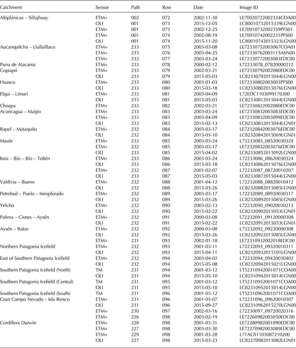
We selected 35 Landsat Thematic Mapper (TM) and Enhanced Thematic Mapper (ETM+) images at Level 1 downloaded from the United States Geological Survey (USGS) website spanning between 2000 and 2003 (Table 1). Images with minimum clouds and mostly acquired in late-summer season were selected.
Landsat Thematic Mapper (TM), Enhanced Thematic Mapper (ETM+) and Operational Land Imager (OLI) images used in this study
Glacier outlines
To identify clean-ice using multispectral data, the band ratio applied to digital numbers (DN) of bands TM3 (0.63–0.69 µm) and TM5 (1.55–1.75 µm) was used as classification method. Subsequently, a 3 × 3 kernel median filter was applied to remove isolated pixels corresponding to rocks on the glacier or snow-cover nearby glacier outlines. The threshold value was obtained from the histogram of each ratio image to discriminate clean-ice and snow surfaces from surrounding terrain (Fig. 2).
Glacier outlines for Bello and Yeso (a) glaciers (clean-ice), Pirámide debris-covered glacier and Rocoso Pirámide rock glacier (b) in the Maipo catchment, Central Andes, as seen in Landsat ETM+ image (24 March 2003). The band ratio of bands TM3 and TM5 and a threshold value were used to discriminate clean-ice from surrounding terrain. Supported by ground observations, debris-covered glaciers and rock glaciers were manually digitized on screen using Band 8 at 15-m spatial resolution. Note the existence of clean-ice exposed in the supra-glacial lake and surface depression on the Pirámide debris-covered glacier (c) and the steep front and distinctive series of ridges and furrows of Pirámide rock glacier (d). Location of glaciers is shown in Figure 3.

Glacier distribution in the Desert Andes (17°30′–32° S) and Central Andes (32–36° S). Glacier distribution varies as a result of latitudinal climate and elevation gradients, occurring 188.9 km2 in the Desert Andes and 869.5 km2 in the Central Andes. Mountain groups and individual glaciers are shown.

Despite improved algorithms, automatic classification of debris-covered glaciers and rock glaciers is still challenging and a main source of inaccuracies (Paul and others, Reference Paul2013). While a debris-covered glacier (i.e. valley glacier) has continuous coverage of supra-glacial debris across its width in the ablation zone (Kirkbride, Reference Kirkbride, Singh, Singh and Haritashya2011), a rock glacier contains interstitial ice (Müller and others, Reference Müller, Caflisch and Müller1977) or a matrix of ice, showing evidence of past or present flow (Cogley and others, Reference Cogley2011). An important clue to distinguish debris-covered glaciers from rock glaciers is the existence of clean-ice exposed in supraglacial lakes and surface depressions on debris-covered glaciers (e.g. Sakai and others, Reference Sakai, Takeuchi, Fujita, Nakawo, Nakawo, Raymond and Fountain2000; Benn and others, Reference Benn2012) whereas rock glaciers are identified by their steep fronts and distinctive series of ridges and furrows perpendicular to the direction of flow (Giardino and others, Reference Giardino, Ragmi, Vitek, Singh, Singh and Haritashya2011). Debris-covered glaciers and rock glaciers were manually digitized on screen using Band 8 at 15 m spatial resolution (Fig. 2). Manual editing was also supported by aerial photographs taken in 1996/97 as well as ground, maritime and aerial observations between Tacora and Llullaillaco volcanoes; the catchments of Copiapó, Elqui, Aconcagua, Maipo, Rapel and Petrohué; and both NPI and SPI.
Minimum threshold
Using Landsat 30 m pixel size images, a minimum threshold of 0.01 km2 (1 hectare) has been recommended for the identification of glaciers (Paul and others, Reference Paul2009). We used the threshold value of 0.01 km2, which has been widely used for glacier inventories (e.g. Kääb and others, Reference Kääb, Paul, Maisch, Hoelzle and Haeberli2002; Paul and Andreassen, Reference Paul and Andreassen2009; Bliss and others, Reference Bliss, Hock and Cogley2013; Pfeffer and others, Reference Pfeffer2014). However, mountain groups located between Aucanquilcha and Llullaillaco volcanoes, in the driest part of the Arid Diagonal, were excluded from the analyses to avoid the inclusion of patchy snow cover in the Dry Andes.
Parameters inventoried
We used the UNESCO classification and description (Müller and others, Reference Müller, Caflisch and Müller1977) to define glacier variables to be inventoried in line with international recommendations (Paul and others, Reference Paul2009). The basic information includes: identification code following WGI; name of the glacier; primary classification of WGI; datum; coordinates; catchment code; acquisition date; inventory date; glacier surface area; exposed area (clean-ice); debris-covered area; mean width and length; orientation; and mean elevation.
Glacier catchments
We used the catchment classification data base of DGA (Benitez, Reference Benitez1980) as a hydrographic unit. Because this classification is based on large topographic maps (1:250 000), we improved it by means of the ArcGIS Watershed module. In the absence of surface water, natural regions such as Altiplano and Puna de Atacama were determined following distinctive peaks instead of catchments. In cases of very small catchments at the archipelagic west coast of Palena Province and Patagonia, glacier complexes were labeled per specific rivers, peaks or fjords.
Outlet glaciers were labeled according to contiguity to the icefield and size of the drainage area (Aniya and others, Reference Aniya, Sato, Naruse, Skvarca and Casassa1996). Mountain glaciers other than outlets were grouped as those connected with the icefield but facing away from its main body; and remaining mountain glaciers contributing to a large catchment (e.g. Baker, Pascua and Serrano) but unconnected with its main body were labeled as other than icefields. In the case of SPI, outlets glaciers contributing to the Pacific Ocean were labeled separately from those outlets flowing to the east side, and the rectangle defined by the boundary Agreement of 1998 was excluded. The Strait of Magellan represents a natural division between mainland and the archipelagic area down to Cape Horn.
Glacier classification
The primary morphological classification of UNESCO (Müller and others, Reference Müller, Caflisch and Müller1977; Digit 1) was adopted to distinguish different types of glaciers. However, and beyond Müller and others (Reference Müller, Caflisch and Müller1977), the distinction between clean-ice and debris-covered areas as well as land-terminating and calving glaciers is an important issue for mass-balance considerations. A threshold of 0.25 km2 (Cogley and others, Reference Cogley2011) was used to further distinguish between glacierets (<0.25 km2) and glaciers (>0.25 km2). We added size intervals ranging between 0.05 and 0.25 km2 for discussion and analyses. Ice-bodies smaller than 0.05 km2, including rock glaciers, snowfields or snowpatches are considered to be objects made mainly by ice that may or may not be a glacier (Cogley and others, Reference Cogley2011).
Recent glacier variations
Glacier outlines for 98 large representative glacier complexes across all glacierized regions and size classes were updated to 2015 using 21 Landsat 8 Operational Land Imager (OLI) images (Table 1). Glacier area variations since 2000/03 were determined by comparing changes in terminus position as visible in the imagery for the different periods. The glaciers sampled represent an area of 7461.8 ± 373 km2 in 2000/03, which is ~31% of glacierized area, including glaciers of different characteristics such as rock glaciers and debris-covered glaciers as well as land-terminating and calving glaciers (clean-ice).
Error estimation
Since most of the estimated glacierized area was measured for the first time, we estimated a measurement error based upon outline perimeter and the size of the pixel. In case of clean-ice glaciers these measurements yield an error of ~2%. However, assuming a worst case scenario for debris-covered glaciers and rock glaciers, this error was enlarged to 5% as a representative error. In addition to delineation method, other potential error sources are co-registration, scene quality, clouds, seasonal snow, shadow, drainage divides in the accumulation region or glacier terminus with dead ice (e.g. Paul and others, Reference Paul2009; Bolch and others, Reference Bolch, Menounos and Wheate2010; Paul and others, Reference Paul2013). All these potential errors were minimized by means of manual editing.
RESULTS AND DISCUSSION
Glaciers occur from Tacora volcano in the Altiplano southward to Isla Hoste at Cape Horn (Figs. 3 and 4). Glacier distribution varies due to topographical factors and climate determined by latitude and the elevation of the Andes. Whereas ice-bodies in the Dry Andes are located at high altitude, glaciers in the Wet Andes reach down to sea-level. Figure 5 depicts the predominance of glaciers of 0.01–1 km2 ~3700 m a.s.l. in the Central Andes (30–35° S), while glaciers larger than 10 km2 occur between 800 and 2000 m a.s.l. and are concentrated in the Patagonian Andes and Tierra del Fuego (43–56° S).
Glacier distribution in the Lakes District and Palena Province (36–46° S) and Patagonia and Tierra del Fuego (46–56° S). Glaciers from Itata to Cisnes catchments cover 1478.8 km2 and 21 171 km2 occurs from Aysén catchment southwards, along the Patagonian Andes and Tierra del Fuego. Mountain groups and individual glaciers are shown.

Glacier size vs mean elevation for glaciers inventoried (a) and glacier size vs latitude (b). Smaller ice-bodies are found at high altitude in the Desert Andes over 4000 m a.s.l. whereas the largest glaciers are found in the Patagonian Andes, where outlets reach the sea. X-axis in both figures are plotted in logarithmic scale.

San Rafael (ca. 724 km2), an outlet glacier of the NPI is the lowest latitude tidewater glacier. Pio XI, an outlet glacier on the west side of the SPI is the largest glacier, with an area of 1246 km2. It is the only glacier larger than 1000 km2, and accounts alone for 5.2% of the total glacierized area. Glaciers (ice-bodies) inventoried were morphologically classified into five main types: icefield and outlet, valley, mountain, glacierets and snowfields, and rock glaciers.
Glacier number and areas
The inventory contains 24 005 ice-bodies larger than 0.01 km2, covering an area of 23 708 ± 1185 km2, which corresponds to ca. 3.1% of the Chilean territory. The results are presented as total number of glaciers and glacierized area by glaciological zone, region and catchment (Table 2) and as number of glaciers per size class (Table 3).
Total number and area of inventoried glaciers by zone, region and catchment using 2000/03 Landsat data
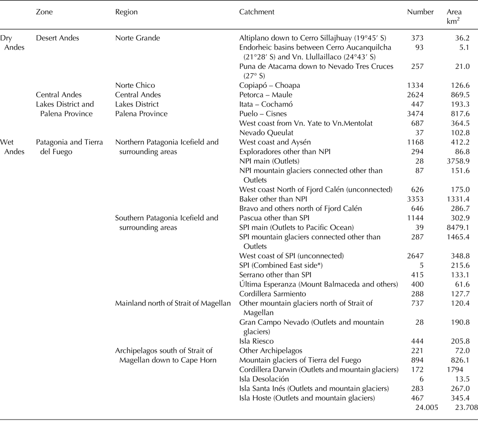
*A portion of the drainage area of five east side glaciers contributing to the Atlantic Ocean.
Number of glaciers per size class inventoried using 2000/03 Landsat data

Uncertainties in the final inventory are due to the occurrence of snowfields that may remain for more than two summer seasons, the absence of ice flow or the lack of current ice in a rock glacier. All these uncertainties are more critical in ice-bodies smaller than 0.05 km2. Although misclassification of rock glaciers does not largely alter the total glacierized area (e.g. 259.4 km2), the inclusion of small ice-bodies largely hampers the number of glaciers inventoried (e.g. 10 707 glaciers are smaller than 0.05 km2). If ice-bodies smaller than 0.05 km2 are excluded, the number of ice-bodies decreases to 13 298, with a decrease of 3% in area yielding a glacierized area of 23 448 ± 1172 km2.
When all the glacierets are excluded (<0.25 km2), the total number of 5748 glaciers yields a glacierized area of 22 567 ± 1128 km2, which lies within the error estimates for satellite-derived inventories. Therefore, a decrease of 75% in number of ice-bodies only implies a decrease of 5% in glacierized area. Consequently, based on a decadal-scale glacier inventory, a threshold value of 0.01 km2 can be misleading and time consuming due to rapid glacier changes, and a threshold value of 0.05 km2 is preferable.
Minimum threshold
The minimum threshold used determines the number of small ice-bodies (<0.05 km2). To reduce errors in sea-level rise estimates, a glacier inventory using a threshold down to 0.01 km2 is required to consider the significant contribution from very small glaciers (Bahr and Radić, Reference Bahr and Radić2012). However, at those scales the difference between glaciers and snowpatches is blurred (Bahr and Radić, Reference Bahr and Radić2012).
The minimum threshold varies in existing inventories worldwide depending on objectives and resources available (Pfeffer and others, Reference Pfeffer2014). Different threshold values have been used: 0.01 km2 at the Antarctic Peninsula (Bliss and others, Reference Bliss, Hock and Cogley2013); 0.02 km2 for Western Himalaya (Frey and others, Reference Frey, Paul and Strozzi2012); 0.1 km2 (Schiefer and others, Reference Schiefer, Menounos and Wheate2008) and 0.05 km2 for British Columbia (Bolch and others, Reference Bolch, Menounos and Wheate2010) and 0.05 km2 for northern Patagonia (Paul and Mölg, Reference Paul and Mölg2014). The division of an ice-complex into individual glaciers can also significantly make the number of glaciers vary; therefore it can be an arbitrary quantity (Pfeffer and others, Reference Pfeffer2014) with the glacier surface area being the most important parameter.
Glacier distribution by zones
Desert Andes
Glaciers and rock glaciers of the Desert Andes cover 188.9 km2, representing about 0.8% of the Chilean glacierized area, of which 105.7 km2 (55% of the zone) correspond to 1368 rock glaciers. Twelve glaciers, mostly found at the Altiplano, Copiapó and Huasco catchments, are larger than 1 km2.
Tropical glaciers are located north of the Arid Diagonal (Vuille, Reference Vuille, Singh, Singh and Haritashya2011), as ice-covered volcanoes of northernmost Chilean Altiplano such as Pomerape, Parinacota, Acotango and Guallatire. Cerro Sillajhuay (19°45′ S) contains the last glacier prior to the development of hyper-arid conditions further south. Tropical glaciers of the Chilean Altiplano (17°30′–19°45′ S) amount to <1% of the total glacierized area.
The driest part of the Desert Andes occurs between Cerro Aucanquilcha (21°28′S), in the Loa catchment, and Llullaillaco volcano (24°43′ S) at the high plateau of Puna de Atacama where only rock glaciers can be found. Large rock glaciers have been observed at Cerro Aucanquilcha, San Pedro and San Pablo volcanoes (Payne, Reference Payne1998).
In the Norte Chico, at the southern tip of the Arid Diagonal, relatively large glacierets appear at Llullaillaco volcano, Nevado Tres Cruces (27°05′ S) and Cerro Muerto. Mountain glaciers occur at Cerro El Potro (28°23′ S), in the Copiapó catchment, where Del Potro glacier, 4.8 km2, is the largest one of the entire Norte Chico. Some other large glaciers of Norte Chico are Tronquitos, Maranceles and Estrecho. Glacier coverage decreases in the Elqui and Choapa catchments, covering altogether 22.3 km2.
Garín (Reference Garín1987) estimated 106.8 km2 in 92 ice-bodies between the Altiplano and Elqui catchment, which is lower than our estimate of 188.9 km2 distributed in 2057 ice-bodies for the same Andean area. In the case of Huasco catchment, 152 ice-bodies covering 23.17 km2 were identified using satellite data of 2004 (Nicholson and others, Reference Nicholson2009), whereas we identified 334 ice-bodies covering 32.6 km2. Although former inventories are not directly comparable with our results, the reduction in glacierized area is interpreted as glacier shrinkage.
Central Andes
The glacierized area of the Central Andes is 869.5 km2, ca. 3.6% of the Chilean glacierized area, of which 289.9 km2 (33% of the zone) correspond to 1472 rock glaciers. A number of 153 glaciers are larger than 1 km2, covering 489 km2 (57% of the zone) and 627 glaciers are larger than 0.25 km2, covering 708 km2 (82%). In this zone, glaciers with distinctive tongues reach significant dimensions (>10 km2) at three main catchments. The most glacierized one is Maipo with 388.3 km2 of glaciers, followed by Rapel with 292.3 km2 and Aconcagua with 135.8 km2, and together containing 95% of the glacierized area of the Central Andes. The mean elevation of glaciers is 3700 m, which is relatively low and goes in line with the decrease in the elevation of the Andes southwards. 65% of the glaciers are oriented to the south and southeast.
The Juncal – Olivares glacier complex (ca. 72.8 km2) comprises the watershed between the Aconcagua and Maipo catchments. Other several large complexes located at Maipo catchment are Loma Larga – Morado; Tupungato; Marmolejo – San José; Bello – Pirámide; Argüelles and Maipo volcano. Picos del Barroso mountain complex comprises the watershed of Maipo and Rapel catchments, while the group of Palomo volcano with ca. 92.5 km2 is the largest complex of the Central Andes. Located at Rapel catchment, Universidad glacier, with 27.5 km2 is one of the largest of the Central Andes. A smaller group at Rapel catchment is the Tinguiririca complex, which contains several unnamed glaciers. Glacier coverage is reduced drastically at Maule and Mataquito catchments. At the Peteroa – Azufre complex, the southernmost large glaciers (>5 km2) of the Central Andes are found. In addition, few isolated ice-covered volcanoes such as Descabezado Grande, Cerro Azul, Nevado Longaví and Nevados de Chillán still have a large coverage of glaciers.
In the Aconcagua catchment, Valdivia (Reference Valdivia1984) inventoried 267 ice-bodies with an area of 151.2 km2 using air photographs, and Bown and others (Reference Bown, Rivera and Acuña2008) 159 glaciers covering 121.2 km2 using satellite data of 2003. In the Maipo catchment, 647 glaciers were inventoried covering 421.9 km2 (Marangunic, Reference Marangunic1979), and at Rapel catchment, 507 ice-bodies covering 328 km2 were inventoried (Caviedes, Reference Caviedes1979; Valdivia, Reference Valdivia1984). These earlier inventories also indicate generalized glacier shrinkage in the Central Andes.
Lakes District and Palena Province
Glaciers in the zone from Itata catchment to Cisnes catchment cover 1478.8 km2, representing ca. 6.3% of the Chilean glacierized area. At the northern sector between the catchments of Itata and Petrohué, Lakes District contains 17 large ice-covered volcanoes such as Sierra Nevada, Villarrica, Mocho-Choshuenco and Osorno as well as Mount Tronador, covering together an area of 193.3 km2. A total glacierized area of 261.82 km2 was previously determined between Bío-Bío and Petrohué catchments (Rivera, Reference Rivera1989) confirming the glacier shrinkage trend also in this area. The largest glacier area, covering 1285 km2, is found at the southern sector between Cochamó and Cisnes catchments, including Yate, Michinmahuida, Corcovado and Melimoyu, four ice-covered volcanoes of Palena Province, where many small mountain glaciers also straddle the crest of the coastal range. In addition, Cordón Inexplorado, Cordón Pico Alto, Cordón Yelcho and Nevado Queulat are the largest inner ice-complexes contributing to Blanco, Puelo, Yelcho and Queulat catchments, respectively.
Patagonian Andes and Tierra del Fuego
From Aysén catchment southwards, the Andes range is characterized by a deeply indented glaciated coastline and its inner icefields. The Patagonian Andes represent 89.3% of the total glacierized area, covering ca. 21 171 km2. At the western coastal range of Patagonia, the four ice-covered volcanoes Mentolat, Cay, Macá and Hudson and the Erasmo complex are the largest ice masses prior to the extent of the main Patagonian icefields.
The NPI and SPI are the largest ice masses, where the small number of 66 large outlet glaciers predominate. These calving glaciers cover a total area of 12 138 km2, representing ~51% of the Chilean glacierized area. In addition, we have to add 87 mountain glaciers connected with the main body of NPI, covering 151.6 km2; 2647 mountain glaciers connected with the main body of the SPI, covering 1465.4 km2; and 2647 mountain glaciers on the west side of SPI, covering 348.8 km2. This large number of mountain glaciers located in the periphery of the main icefields and those other than icefields found at Baker, Pascua and Serrano catchments, have never previously been inventoried.
On the west maritime side, outlet glaciers directly reach sea-level in a fjord. On the other hand, east side continental outlets terminate in fresh water lakes and contribute to three large catchments such as Baker, Pascua and Serrano. In addition, smaller icefields with outlet glaciers larger than 100 km2 and many mountain glaciers also exist north and south of the Strait of Magellan, such as Gran Campo Nevado, Isla Santa Inés, Cordón Navarro, Cordillera Darwin and Isla Hoste.
Glacier classification
Land-terminating ice masses such as mountain and valley glaciers are widely spread along the country, predominating in number (5687) whereas 79 large calving glaciers of Patagonia and Tierra del Fuego represent 12 848 km2 (54% of glacierized area). Meltwater from land-terminating glaciers importantly contributes to run-off if they constitute a large ice-complex. On the other hand, calving glaciers of Patagonia have accounted for a major contribution to sea-level rise per unit area, which is larger than the contribution from Alaska's glaciers (e.g. Aniya, Reference Aniya1999; Rignot and others, Reference Rignot, Rivera and Casassa2003).
Identification of rock glaciers is not straightforward when only using optical imagery. Their distinction from debris-covered glaciers is important because rock glaciers contain much less ice per volume thereby the total ice volume and its sea-level equivalent of a catchment can be overestimated. However, only further field-based surveys can investigate both the internal structure and ice content of a rock glacier, which are key factors in its dynamics and evolution (Hausmann and others, Reference Hausmann, Krainer, Brückl and Mostler2007).
Despite the fact that Gran Campo Nevado (Schneider and others, Reference Schneider, Schnirch, Acuña, Casassa and Killian2007) and Cordillera Darwin (Holmlund and Fuenzalida, Reference Holmlund and Fuenzalida1995) have been classified as ice caps, we classified them as icefields (i.e. outlets and mountain glaciers) as well as Isla Santa Inés and Isla Hoste because the threshold of 50 000 km2 to classify an ice cap (Benn and Evans, Reference Benn and Evans2010), appears too large even for the entire glacierized area of the Southern Andes. While an ice cap is a dome-shaped ice mass with radial flow, a distinctive feature of an icefield is a large and flat accumulation area in which the catchment area may not be clearly delineated (Müller and others, Reference Müller, Caflisch and Müller1977).
In flat areas where rock outcrops are absent, the location of the ice divides is not straightforward when ice flow data is lacking, so changes in drainage areas reflect trends mainly in ice dynamics rather than surface mass-balance processes alone (Mouginot and Rignot, Reference Mouginot and Rignot2015). Redefined ice-divides and drainage areas from previous studies (e.g. Davies and Glasser, Reference Davies and Glasser2012; Casassa and others, Reference Casassa, Rodriguez, Loriaux, Kargel, Leonard, Bishop, Kääb and Raup2014) have been reported for both the NPI and the SPI due to enhanced ice flow, meaning that changes in ice dynamics propagate far inside the accumulation areas (Mouginot and Rignot, Reference Mouginot and Rignot2015). However, for inventory purposes those changes take place in the inner accumulation areas, which does not largely alter the main glacierized area.
Glacier surface conditions
The total surface area of clean-ice in Chile reaches 20 508 km2, ~86% of the total glacierized area. It is mostly found in Patagonia and Tierra del Fuego as well as in mountain and valley glaciers in Lakes District and Palena Province and partially in the Central Andes. A small amount of clean-ice is found in the Desert Andes. The remaining 15%, including both rock glaciers and debris-covered glaciers, is largely found along the Desert Andes and Central Andes, up to the Maule catchment, where freezing temperatures by elevation and low snow-accumulation rates are characteristics. Due to loss of both continuity and elevation of the Andes, the transition to Mediterranean climate with a wetter summer precludes the occurrence of rock glaciers southwards. However, debris-covered areas can still be found in a wetter climate due to local conditions such as rock-fall and stagnation at Mount Tronador, as the case of Casa Pangue and Blanco glaciers. Large amount of debris coverage also exists in the ablation areas of Grosse, Exploradores, Fiero, Soler, Nef, Colonia, Pared Norte and Pared Sur glaciers within the NPI (46°30′S–47° S), or Chico glacier (49° S) within the SPI, all of them flowing to continental east side.
Recent glacier variations (2000/03–2015)
Different data and methods (i.e. aerial photos, satellite images, algorithms, scale) yield different inventory measurements. However, when comparing the former inventories from the Dry Andes to Petrohué catchment with our results, there is a reduction in glacierized area from 1365 to 1200 km2 and an increase from 1751 to 4973 in the number of glaciers. Decrease in glacierized area is interpreted as glacier shrinkage and the increase in number is attributed to the fragmentation of ice-bodies. Although the existing inventories are not directly comparable, rapid glacier changes have been observed along the country, from the Altiplano down to Cordillera Darwin between 2000–03 and 2015 (Fig. 6).
Area changes between 2000/03 and 2015 for 98 glaciers across all glacierized regions and size classes. Rapid glacier changes have been observed from the Altiplano down to Cordillera Darwin. Decline in glacier area is mostly affecting to clean-ice land-terminating glaciers at different rates whereas debris-covered glaciers and rock glaciers in the Desert and Central Andes appear nearly unchanged in their extent. The uneven recession trend in the Patagonian Andes is explained by the dynamics of calving glaciers.

Decline in glacier area is mostly affecting clean-ice (both land-terminating and calving) glaciers at different rates resulting in changes in their geometry such as marked ice front retreat (Figs. 7 and 8). The total area loss for 77 glaciers is ~−92.3 ± 4.6 km2. However, 21 rock glaciers and debris-covered glaciers in the Desert and Central Andes appear nearly unchanged in their extent. Even though different type of glaciers can indicate distinct glacier sensitivities to climatic regimes, local conditions are important in explaining current glacier response, because some large calving glaciers in Patagonia and Tierra del Fuego have been stable in recent years (e.g. Nef, O'Higgins) even in the zone where the largest retreating rates are observed (e.g. Colonia, Jorge Montt, Marinelli).
Changes in terminus position between 2003 and 2015 for glaciers located at different zones. In the Desert Andes, Tronquitos glacier, one of the largest glaciers of Copiapó catchment, retreated −0.18 km2. A larger retreating rate of −0.36 km2 is observed at Olivares Alfa, a glacier located at the Maipo catchment, Central Andes. An unnamed tongue of the west side of Inexplorado complex at Palena Province retreated −0.48 km2.

The largest retreating rate is observed in the Patagonian Andes and Tierra del Fuego. Colonia glacier, one of the five largest outlet glaciers of the Northern Patagonia Icefield (NPI) retreated −4.5 km2 and Marinelli glacier in the Cordillera Darwin, retreated −7.0 km2 between 2001 and 2015.

The glacierized areas of all ice-covered volcanoes of the Altiplano are shrinking. The largest retreat is observed at Parinacota volcano with −0.9 km2, whereas at Acotango volcano and Cerro Sillajhuay a more moderate retreat of −0.13 and −0.03 km2 is observed. However, large rock glaciers of Tacora volcano, Cerro Arintica, Cerro Aucanquincha, San Pedro and San Pablo volcanoes showed no frontal change.
At Norte Chico, a large retreat rate is observed at Del Potro glacier with −0.17 km2 and Tronquitos glacier with −0.18 km2. Between Estrecho glacier and Cerro Volcán the retreat rate is more moderate (~ −0.5 km2). Large rock glaciers such as Maranceles and Las Tolas at Copiapó, and Elqui catchments, respectively, also showed no frontal change.
Larger recession rates in the Central Andes are observed at Olivares Alfa glacier with −0.36 km2 and Universidad glacier with −0.17 km2 whereas other large glacier such as Cipreses, Cortaderal and Palomo decreased < −0.04 km2. Debris-covered glaciers such as Pirámide and Cachapoal also showed no frontal change.
Ice-covered volcanoes and mountain glaciers of the Lakes District are retreating at contrasting rates. High retreat rates have been observed at Villarrica volcano with −0.56 km2, at Mocho-Choshuenco volcano with −0.02 km2 and at Osorno volcano with −0.58 km2. At the northern side of Mount Tronador, the Casa Pangue glacier retreated −0.17 km2 whereas at its southern side, Blanco glacier showed no change even though they are both covered by debris.
Contrasting retreat rates are also observed at Palena Province as the case of Cordón Inexplorado, where two unnamed glaciers (west side) retreated −0.48 and −0.46 km2. However, two unnamed glaciers of Cordón Yelcho (west and east sides) showed no frontal change. A moderate rate is observed at Michinmahuida volcano (Amarillo glacier) with −0.05 km2, whereas the northern tongue of Queulat complex (Rosselot glacier) retreated −0.9 km2 and contrastingly its southern tongue (Ventisquero Colgante del Queulat), showed no frontal change.
The magnitude of recession in Patagonia and Tierra del Fuego is the largest one in the Chilean Andes because of the large size and dynamics of calving glaciers (e.g. Warren and Aniya, Reference Warren and Aniya1999; Rivera and others, Reference Rivera, Corripio, Bravo and Cisternas2012). Large recession rates up to −10 km2 in the case of Greve glacier and −7.6 km2 for Marinelli in Cordillera Darwin are observed. Other west facing glaciers such as Gualas and San Quintin within NPI retreated −3.2 and −5.0 km2, respectively. However, on the east side of NPI, Nef glacier retreated at a more moderate rate of −0.5 km2, whereas Colonia glacier retreated at a larger rate of −4.5 km2, a contrasting behavior of two neighboring glaciers.
SUMMARY AND OUTLOOK
The first comprehensive glacier inventory of Chile, which will be available to the scientific community, includes a large glacierized area south of 46° S, especially along the Patagonian Andes and Tierra del Fuego. Large glacierized areas along the Altiplano, Palena Province and the periphery of the Patagonian icefields and surrounding areas are inventoried. Chilean glaciers, with an area of 23 708 km2, represent nearly 80% of the glacierized area of the entire Southern Andes. This estimate is more than 2000 km2 larger than previous glacier compilations, and is a large portion of the glacierized area of all countries of South America.
Glaciers across all glacierized regions and size classes are retreating at different rates. The observed warming in Southern South America (Rosenblüth and others, Reference Rosenblüth, Fuenzalida and Aceituno1997) and the consequent rise in the snowlines (Carrasco and others, Reference Carrasco, Casassa and Quintana2005) is interpreted as the main reason. However, the spatial pattern of glacier shrinkage across the Andes of Chile is explained by the contrasting response of debris-covered glaciers in the Desert and Central Andes compared to the large recession trend in Patagonia, which is enhanced by the dynamics of calving glaciers.
A recent warming of +0.25 °C per decade in the Andes between 17° S and 37°S has been established on the basis of observational data and modeling (Falvey and Garreaud, Reference Falvey and Garreaud2009). MODIS data indicate a high variability in the snow-covered area and its depletion depending on wet or dry years (i.e. El Niño Southern Oscillation) (Minora and others, Reference Minora2015). Scant geodetic mass-balance observations in the Central Andes indicate larger thinning rates (ca. –2.2 m a−1) on clean-ice glaciers whereas a debris-covered glacier showed no elevation change between 2009 and 2012 (Barcaza and others, Reference Barcaza2015).
AUTHOR CONTRIBUTION STATEMENT
G.B. led the study and wrote the manuscript. S.N. and J.L.G. helped in writing and scientific discussion. All the other co-authors contributed to data processing and analyses.
ACKNOWLEDGMENTS
This research was supported by Dirección General de Aguas (DGA), Ministry of Public Works, Chile, from where this first national glacier inventory is available. S. U. Nussbaumer and J. L. García acknowledge support from the EPFL Leading House for scientific and bilateral cooperation between Switzerland and Chile. The support in data processing of Rodrigo Sáez, Claudio Durán, Andrés Ceballos, Camilo Muñoz, Miguel Barros, Carlos Mendoza, Tamsin Sepúlveda and Jorge Huenante, is greatly appreciated. Comments from Bruce H. Raup, National Snow and Ice Data Center (NSIDC), an anonymous reviewer and the scientific editor, Ian Allison, are greatly appreciated. Mr. Felipe Herrera (R.I.P.), a member of DGA staff who tragically died in 2012, worked in the identification of rock glaciers; this paper is dedicated to his memory.


 Open access