

ARCHAEOLOGICAL EVIDENCE FOR LANDSCAPE USE & THE ROLE OF CAUSEWAYED ENCLOSURES DURING THE EARLIER NEOLITHIC
Causewayed enclosures began to be constructed in southern Britain from the late 38th century bc (Whittle et al. Reference Whittle2011, 878–5; Bayliss et al. Reference Bayliss, Healy, Whittle and Cooney2011, 684). The role of these earthworks, which are characterised by single or multiple concentric circuits of interrupted ditches, has been heavily debated (eg, Evans Reference Evans1988; Edmonds Reference Edmonds1993, 102–34; Thomas Reference Sponheimer and Cerling1999, 38–45; Whittle et al. Reference Whittle2011, 5–12; Albrecht Reference Albrecht2011, 8–50). The presence of substantial amounts of pottery, flint knapping debris, and animal bones within the ditches initially prompted excavators to suggest they were settlements (eg, Leeds Reference Leeds1928, 466; Curwen Reference Curwen1931, 108–9; Crawford Reference Crawford1933, 344; Reference Crawford1937, 210; Wheeler Reference Warham1943, 81; Case Reference Case1982, 2; Avery et al. Reference Avery, Cain, Case, Cram, Cummins, Harrison, Murphy, Powell, Startin, Western, Whittle and Williams1982, 25; Robertson-Mackay et al. Reference Roberts, Coward, Ewing, Cole and Lucas1987, 59–60). However, in recent decades with the exception of earlier Neolithic enclosures found in the far south-west of England that may have been used for permanent settlement (Mercer Reference Mercer1981; Reference Mercer2001, 43–44; although see Davies Reference Davies2010, 162–4, 176–7), interpretations suggest that causewayed enclosures were monuments which hosted temporary gatherings, playing a role in bringing together communities who usually resided elsewhere (eg. Smith Reference Slovak and Paytan1965, 19; Thomas Reference Sponheimer and Cerling1999, 42; Oswald et al. Reference Oswald, Dyer and Barber2001, 123–6, 132; Cummings Reference Cummings2008, 142; Beadsmoore et al. Reference Beadsmoore, Garrow and Knight2010, 129; Whittle et al. Reference Whittle2011, 893–5; Thomas Reference Thomas2016, 7, 12). The presence of natural silting at several of these sites, interspersed with features that may demonstrate the ditches were intermittently recut, could indicate that visits to causewayed enclosures were episodic and may have been seasonal (eg, Smith Reference Slovak and Paytan1965, 7, 20; Mercer Reference Mercer1988, 94; Mercer & Healy Reference Mercer and Healy2008, 755; Pryor Reference Price1998, 364; Legge Reference Legge2008, 554). Archaeological evidence also suggests that many of the artefacts found within the enclosure ditches were selectively deposited and that the butchered remains of cattle, also frequently found within enclosure ditches, could also be associated with feasting activity (eg, Smith Reference Smith1971, 100; Whittle et al. Reference Whittle, Bayliss and Healy1999, 357; Evans & Hodder Reference Evans and Hodder2006, 319; Mercer & Healy Reference Mercer and Healy2008, 755, 762; Darvill et al. Reference Darvill, Bayliss, Costen, Hambleton, Healy, Housley, O’Connell, Pollard, Snashall, Whittle, Constant and Gray2011, 139, 195; Thomas Reference Thomas2016; although see Parmenter et al. Reference Parmenter, Johnson and Outram2015). The presence of both articulated formal burials and disarticulated human remains within the enclosure ditches demonstrates that these sites were also associated with mortuary rites and the commemoration of the dead (eg, Drewett et al. Reference Drewett, Cartwright, James, Thomas and O’Connor1977, 225–6; Pryor Reference Price1998, 362; Mercer & Healy Reference Mercer and Healy2008, 759–60).
Archaeological evidence for settlement patterns during this period has also been the subject of competing interpretations. Discovery of substantial timber buildings of early 4th millennium bc date has been used by some authors to argue that early agriculturalists were fully sedentary and heavily reliant on intensive mixed farming, with individuals obtaining all their resources through keeping livestock and cultivating cereals close to permanently occupied settlements (eg, Rowley-Conwy Reference Roe2003; Reference Rowley-Conwy2004, 96; Reference Rowley-Conwy2011; Rowley-Conwy & Legge Reference Rowley-Conwy2015). Others, however, suggest there may have been greater temporal and regional diversity in subsistence and settlement strategies during the course of the Neolithic (eg, Thomas Reference Thomas2013, 418). In Britain, substantial timber buildings are part of a diverse range of evidence for occupation, that also includes pits, lithic scatters, and more ephemeral structural remains (eg, Anderson-Whymark & Thomas Reference Anderson-Whymark and Thomas2012; Brophy Reference Brophy2015). The latter are frequently interpreted as temporary camps and could suggest that some members of early farming communities were residentially mobile, moving episodically between occupation sites and visiting a variety of different geographical locations to obtain dietary resources (eg, Pollard Reference Pioffet1999, 82; Whittle Reference Wheeler1997, 21; Reference Whittle2003, 43; Garrow et al. Reference Garrow, Beadsmoore and Knight2005, 155). Some authors argue that patterns of land use and mobility may also have been structured around visitation of causewayed enclosures and suggest that these monuments ‘acted as staging posts in an annual cycle of movement around loosely defined territories’ (Oswald et al. Reference Oswald, Dyer and Barber2001, 119). Rather than Neolithic communities obtaining all of their resources through year round sedentary intensive mixed farming at permanently occupied settlements, these authors propose that patterns of land use, subsistence, and mobility were complex and socio-culturally variable (eg, Thomas Reference Thomas2013, 411; Leary & Kador Reference Leary and Kador2016).
Analysis of material culture and the derivation of raw materials that were used to manufacture many of the artefacts found at causewayed enclosures, such as pottery and worked stone, has also been employed as a proxy for reconstructing patterns of land use. Causewayed enclosures are frequently located on the slopes of elevated promontories (Oswald et al. Reference Oswald, Dyer and Barber2001, 91, 109–10), and are sometimes found in pairs, situated side by side on adjacent spurs of the same hilltop (ibid., 112–13; Allen et al. Reference Allen, Leivers, Ellis, Stevens, Clelland, Bayliss, Butler, Gale, Gibson, McKinley, Knight, Mepham, Scaife and Stevens2008; Healy Reference Healy2008, 3; Darvill et al. Reference Darvill, Bayliss, Costen, Hambleton, Healy, Housley, O’Connell, Pollard, Snashall, Whittle, Constant and Gray2011, 196; Dixon et al. Reference Dixon, Bayliss, Healy, Whittle and Darvill2011, 465). Some researchers suggest that the contrasting form and fabric of artefacts found in adjacent enclosures may indicate that each had a different functional role (Allen et al. Reference Allen, Leivers, Ellis, Stevens, Clelland, Bayliss, Butler, Gale, Gibson, McKinley, Knight, Mepham, Scaife and Stevens2008, 308–12). However, at the Hambledon Hill complex in Dorset, England, which includes two early Neolithic long barrows and two causewayed enclosures, a larger main enclosure and the smaller Stepleton enclosure situated side by side on adjacent spurs of the hill (Fig. 1), analysis of raw materials used to manufacture the majority of artefacts found within the adjacent enclosures indicates that these may have been sourced from the sector of landscape each enclosure overlooks (Smith et al. Reference Smith2008, 646). Based on this discovery, the excavators propose that each enclosure could have served a distinctive social group who occupied a specific sector of the landscape (Roe Reference Roe2009, 28) and that the immediate sector of landscape visible from each enclosure provides an approximate index of the catchment occupied by the community it served (Healy Reference Healy2004, 31; Mercer & Healy Reference Mercer and Healy2008, 767).
Plan of Hambledon Hill (after Mercer & Healy Reference Mercer and Healy2008; reproduced with permission)
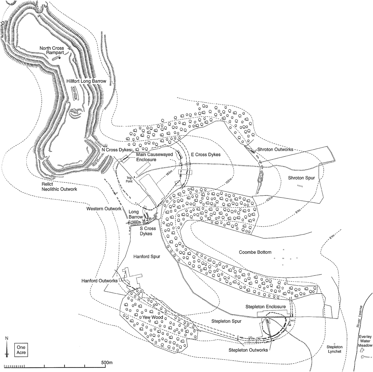
The Hambledon Hill complex was the subject of a major campaign of rescue excavation between 1974 and 1986 (Mercer & Healy Reference Mercer and Healy2008, 11; Mercer Reference Mercer1988; 1980). Bayesian modelling of radiocarbon dates suggests early Neolithic activity on the hill began 3685–3640 cal bc and ended 3345–3305 cal bc (95% probability, OxCal v.3.10; Healy et al. Reference Healy, Bayliss, Whittle, Allen, Mercer, Rawlings, Sharples and Thomas2011, 145; also see Bayliss et al. Reference Bayliss, Healy, Bronk Ramsey, McCormac and Mercer2008). The architecture of the very earliest dated phases of the complex includes the south long barrow and the excavators suggested that the morphology of this monument bears affinities to the architecture of long barrows found on the Cretaceous Chalk downs to the east (Fig. 2; Mercer & Healy Reference Mercer and Healy2008, 766; Mercer Reference Mercer2006, 70; Reference Mercer2009). However, despite being located in very close proximity to the Chalk, to the immediate east and north-east (Fig. 2), few of the objects found at Hambledon Hill were manufactured from Chalk or Sarsen, sources of which lie in this direction (Roe Reference Robertson-Mackay, Butcher, Cameron, Chandra, Conway, Dawes, Dimes, Grigson, Healey, Helbaek and Higgs2008, 633; Mercer & Healy Reference Mercer and Healy2008, 767; Roe Reference Roe2009, 27). Likewise, Decorated Bowl pottery, which is frequently found at early Neolithic sites in the east and south-east of England (for instance, in the Thames valley, Sussex, East Anglia, and Wessex: Zienkiewicz Reference Zazzo1999, 286; Bayliss et al. Reference Bayliss, Healy, Whittle and Cooney2011, 762–3) was only a minor part of the ceramic assemblage at Hambledon (Smith Reference Smith2008a, 592; also see Pioffet Reference Pioffet2015).
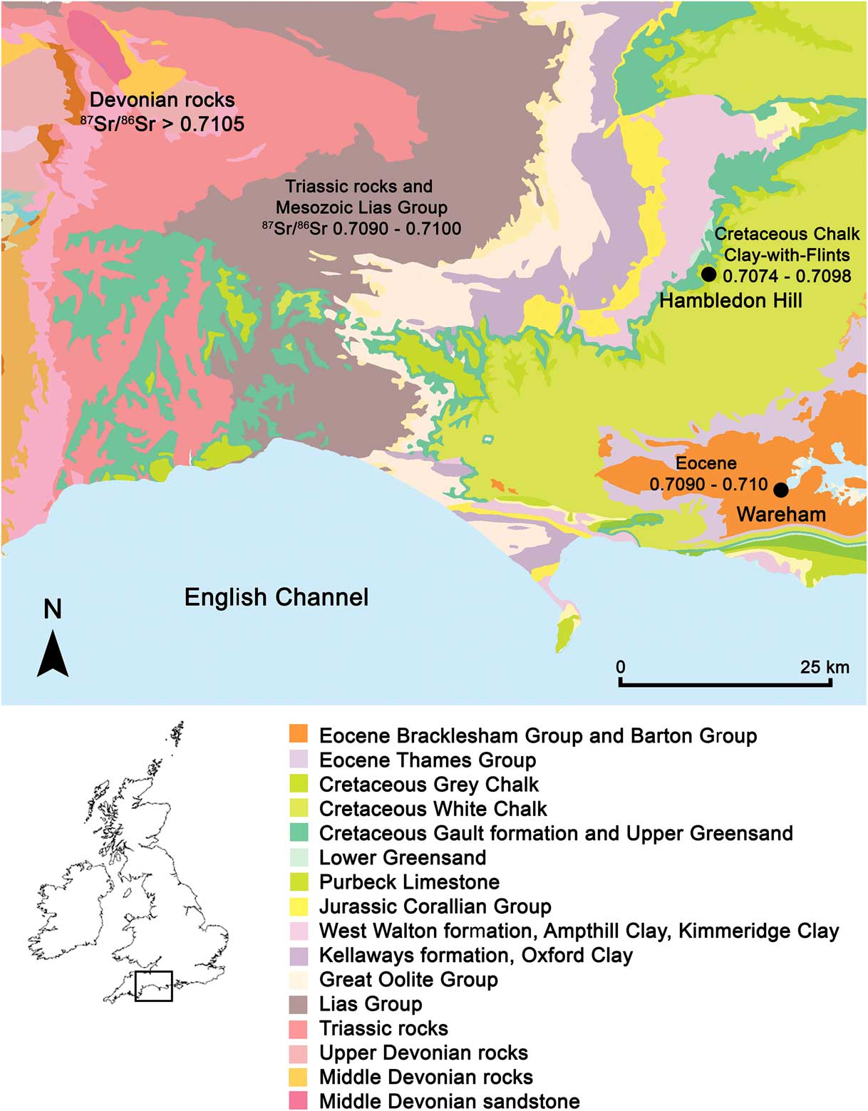
Location of Hambledon Hill in relation to bedrock geology and measured 87Sr/86Sr bioavailable values (Based on British Geological Survey and Ordnance Survey map data, reproduced with permission of the British Geological Survey and Ordnance Survey, © NERC/Crown copyright (2016). Bioavailable 87Sr/86Sr ranges after Montgomery et al. (Reference Montgomery, Evans and Wildman2006); Evans et al. (Reference Evans, Montgomery, Wildman and Boulton2010); Chenery et al. (Reference Chenery, Müldner, Evans, Eckardt and Lewis2010), & Warham (Reference Thomas2011))
Instead, analysis of material culture suggests that, for the majority of the period Hambledon Hill was in use, it was closely connected to the area of landscape that lies to the south and west. Ceramics found at the site reflect styles common to the south-western region of England (Healy Reference Healy2004, 31; 2006, 11; Mercer & Healy Reference Mercer and Healy2008, 591, 767). The larger main enclosure overlooks the landscape to the west (Fig. 1). Analysis of clays used to manufacture the pottery found in this enclosure suggests the majority could have been sourced from the Upper–Middle Jurassic lithologies that lie in this direction (Fig. 2): pottery fabric groups 7, 8, and 2 may have been manufactured from Kimmeridge Clay and Oolitic Limestone, which crop out to the west of the hill (Healy Reference Healy2006, 11; Smith Reference Smith2008a, 587, 595–6; Darvill Reference Darvill2008, 615, 617, 620–1). Many of the worked stone objects found within the main enclosure may also originate from sources that lie in this direction, with querns frequently being manufactured from Greensand, the closest source of which is located to the immediate west of the hill (Fig. 2; Roe Reference Robertson-Mackay, Butcher, Cameron, Chandra, Conway, Dawes, Dimes, Grigson, Healey, Helbaek and Higgs2008, 632–3).
In contrast to the main enclosure, the Stepleton enclosure (Fig. 1), situated on the adjacent spur of the hill, faces toward the coastal zone of southern Dorset. Analysis of objects suggests that both the clays used to make ceramics (fabric group 6) and worked stone found within this enclosure may derive from lithology of Eocene age located in this direction, close to the coast, approximately 25 km away (near to Wareham, Dorset, Fig. 2; Roe Reference Robertson-Mackay, Butcher, Cameron, Chandra, Conway, Dawes, Dimes, Grigson, Healey, Helbaek and Higgs2008, 633; 2009, 28–9; also see Smith Reference Smith2008a, 587, 595; Darvill Reference Darvill2008, 619; Smith et al. Reference Smith2008, 646; Mercer & Healy Reference Mercer and Healy2008, 767). High densities of recorded finds along the coastal zone of southern Dorset indicate this region may have been a particular focus for activity during the Early Neolithic (Field Reference Field2008, 46–8). Analysis of lithics found at Hambledon Hill, which were manufactured from chert, suggests these could also have been sourced from a similar area (Saville Reference Rowley-Conwy and Legge2008, 651).
Links between Hambledon and areas within the west and south-west of England are also implied by the presence of other materials that were imported from much further afield in this direction. Many of the quernstones found at the site were manufactured from Old Red Sandstone (Roe Reference Robertson-Mackay, Butcher, Cameron, Chandra, Conway, Dawes, Dimes, Grigson, Healey, Helbaek and Higgs2008, 632–3; Smith et al. Reference Smith2008, 645–6). Devonian Old Red Sandstone crops out in several areas of Britain (Barclay et al. Reference Barclay, Browne, McMillan, Pickett, Stone and Wilby2005, 3–4), the closest sources to Hambledon Hill being in Somerset and north Devon, c. 40 km away to the west. Connections even further afield, are also implied by the presence of Gabbroic pottery, which was imported to Hambledon from the Lizard Peninsula in Cornwall (Smith Reference Smith2008a, 587, 590; Darvill Reference Darvill2008, 615). The majority of stone axes and adzes found at the complex also originate from sources in Cornwall (Smith Reference Smith2008b, 630). Use of the causewayed enclosure complex at Hambledon was long-lived, lasting over 300 years, with both the adjacent enclosures on the hill remaining in use for much of this time (Healy et al. Reference Healy, Bayliss, Whittle, Allen, Mercer, Rawlings, Sharples and Thomas2011, 145). Consistency in the sourcing of artefacts throughout this period suggests that links between Hambledon and regions to the west and south were maintained over time (Smith et al. Reference Smith2008, 646; Mercer & Healy Reference Mercer and Healy2008, 756–7).
Whilst being significant locations in the landscape that may have played a role in social gatherings and bringing together communities, some enclosures also appear to have been the focus of episodic conflict (Oswald et al. Reference Oswald, Dyer and Barber2001, 128–30; Bayliss et al. Reference Bayliss, Healy, Whittle and Cooney2011, 718; Whittle et al. Reference Whittle2011, 520). This interpretation arises from the frequent discovery of arrowheads and evidence for burning at enclosures, particularly those located within south-western England (such as Maiden Castle, Dorset: Sharples Reference Sharp1991, 51; Crickley Hill, Gloucestershire: Dixon Reference Dixon1988, 82; 2011, 460: Hembury, Devon: Mercer Reference Mercer1999, 151; and Carn Brae, Cornwall: Mercer Reference Mercer1981, 68; Reference Mercer2003, 61). The excavators of Hambledon Hill suggest that the deaths of four individuals, all adult males, may have occurred during episodes of conflict at the site. The deaths of two of these individuals appear to have been associated with the burning of outworks that were built to surround the site (Mercer & Healy Reference Mercer and Healy2008, 760–1). The excavators suggest individual ST79 2726, who was found on the base of the inner Stepleton outwork ditch: ‘may have been the victim of the catastrophe in which the defences were fired’ during the mid-36th century (Healy et al. Reference Healy, Bayliss, Whittle, Allen, Mercer, Rawlings, Sharples and Thomas2011, 140–1; cf. Mercer & Healy Reference Mercer and Healy2008, 408), whilst the death of individual ST81 3181, who is dated to a similar period and was found in a pit containing scorched rubble and burnt clay, may also have been associated with this event (Mercer & Healy Reference Mercer and Healy2008, 275, 408). The deaths of both of these individuals appear to have been shortly followed by that of a third adult male (ST80 1875), who died 3630–3360 cal bc (95% confidence) and was found lying within the Stepleton outworks, with an arrowhead amongst his ribs (Healy et al. Reference Healy, Bayliss, Whittle, Allen, Mercer, Rawlings, Sharples and Thomas2011, 129, 142–3). A fourth individual, who was also found within the Stepleton outworks with an arrowhead amongst his ribs, may have died later in the history of the complex, at 3500–3130 cal bc (95% confidence, individual ST78 2755, Healy et al. Reference Healy, Bayliss, Whittle, Allen, Mercer, Rawlings, Sharples and Thomas2011, 128, 143; McKinley Reference McKinley2008, 512).
THE APPLICATION OF ISOTOPE ANALYSIS: PRINCIPLES & LIMITATIONS
The excavation of the Hambledon Hill complex led to the discovery of one of the most substantial osteological assemblages of earlier Neolithic date so far found in Britain (McKinley Reference McKinley2008, 504). Use of isotope analysis offers a new means to examine patterns of landscape use during this period (eg, Bentley Reference Bentley2006; Montgomery Reference Montgomery2010; Slovak & Paytan Reference Sharples2011; Price Reference Pollard2015, 75–8). This study applies isotope analysis of tooth enamel to evaluate where the individuals who were buried at Hambledon Hill obtained their childhood diet.
Strontium isotope analysis
Strontium has four naturally occurring isotopes, atoms of the same chemical element that differ in atomic mass as they possess a different number of neutrons: 84Sr, 86Sr, 87Sr, and 88Sr (Faure Reference Faure1986, 118). Strontium-87 is radiogenic, a product of the radioactive decay of rubidium-87 (87Rb; Faure & Mensing Reference Faure and Mensing2005, 76; Dickin Reference Dickin2005, 42–3). Unlike the other isotopes of strontium, the amount of 87Sr gradually increases over geological time scales and 87Sr/86Sr therefore varies geographically according to the age and initial isotope composition of bedrock. Use of strontium isotope analysis for geographic provenancing is based on the principle that humans and animals derive their dietary strontium from biosphere sources. Strontium weathers from rocks, entering soils and ground waters where it becomes available to plants (Capo et al. Reference Capo, Stewart and Chadwick1998, 202–3) and is transferred up the food chain and becomes incorporated into the mammalian skeleton (Montgomery Reference Montgomery2002, 17, 24, 36; 2010, 328; Bentley Reference Bentley2006, 141; Slovak & Paytan Reference Sharples2011, 743–4). Conventionally measured 87Sr/86Sr values do not vary significantly between trophic levels (Graustein Reference Graustein1989, 492; Blum et al. Reference Blum, Taliaferro, Weisse and Holmes2000) and, as tooth enamel is highly resistant to diagenesis, the isotope ratios in teeth are considered to reflect sources to which an individual was exposed whilst the tooth was mineralising (Budd et al. Reference Budd, Montgomery, Barreiro and Thomas2000; Reference Budd, Montgomery, Evans and Chenery2001; Montgomery Reference Montgomery2002; Madgwick et al. Reference Madgwick, Mulville and Evans2012, 741). Measured values in modern plants and waters vary with the age and composition of the underlying lithology (Montgomery et al. Reference Montgomery, Evans and Wildman2006; Evans et al Reference Evans, Montgomery, Wildman and Boulton2010; Warham Reference Thomas2011; Frei & Frei Reference Frei and Frei2011; Willmes et al. Reference Whittle, Pollard and Grigson2013). Comparison of 87Sr/86Sr values in teeth that form at successive stages of childhood to mapped bioavailable values can as such be used to evaluate whether an individual derived dietary resources from the area in which they were buried or whether they may have obtained their childhood diet from further afield (Bentley Reference Bentley2006; Montgomery Reference Montgomery2010; Slovak & Paytan Reference Sharples2011, 743–4). The strontium isotope ratios that human individuals exhibit can also be compared to 87Sr/86Sr ranges bioavailable on lithologies from which artefacts (such as clays for pottery or worked stone, see above) may have been sourced.
Strontium isotope ratios within enamel are therefore a direct proxy for the geographical location from which an individual obtained their childhood diet. However, use of this methodology is also subject to limitations: when interpreting results consideration must be given to the fact that different geographical areas may have the same bioavailable range and can confer similar 87Sr/86Sr values. An individual with an 87Sr/86Sr value comparable to the local range at the site where they are buried may not, therefore, have obtained their diet locally and could have inhabited another region with the same biosphere value. This is similarly problematic when applying the technique to study consecutively mineralising molars: if an individual exhibits the same 87Sr/86Sr value in teeth that mineralise at successive stages of childhood they could either have obtained their dietary resources from the same area throughout a prolonged period during early life; alternatively they could have exploited two different geographically separate areas with similar bioavailable ranges.
For this reason there are limitations to use of this technique at Hambledon Hill, since the two immediate geographical areas to which each enclosure may have been linked through artefact analysis have overlapping 87Sr/86Sr bioavailable ranges. Upper Jurassic Kimmeridge Clay formation may have been the source for the clays used to make pottery deposited within the main enclosure (Fig. 2; see above) and samples of plants and water taken on this formation in southern Britain record measured biosphere 87Sr/86Sr values between 0.7086 and 0.7091 (n=10, mean 0.7088±0.0003, 2σ; Warham Reference Thomas2011, 79). The latter lies close to the Weymouth Member of the Oxford Clay Formation, which can record biosphere values of 0.7092–0.7097 (n=6, mean 0.7094±0.0003, 2σ; Warham Reference Thomas2011, 79). The region of southern Dorset to which the excavators suggest that the Stepleton enclosure was linked (Roe Reference Robertson-Mackay, Butcher, Cameron, Chandra, Conway, Dawes, Dimes, Grigson, Healey, Helbaek and Higgs2008, 633; Smith et al. Reference Smith2008, 646) has been associated with a bioavailable range of 0.7090–0.7100 (Fig. 2; Evans et al. Reference Evans, Montgomery, Wildman and Boulton2010). As such, if individuals exhibit 87Sr/86Sr values between c. 0.7090 and 0.7100 they could have sourced their diet from either of the two immediate regions to which the enclosures have been linked through analysis of material culture.
The 87Sr/86Sr ranges that are bioavailable on these lithologies may also overlap with the predicted bioavailable range at Hambledon Hill itself and that associated with the Cretaceous Chalk to the immediate east of the site. Like the lithologies that lie to the immediate east, Hambledon Hill is composed of Chalk (British Geological Survey (BGS)/Natural Environment Research Council (NERC) 2016). In Britain, samples of plants and water taken on Chalk record 87Sr/86Sr values between 0.7074 and 0.7087 (mean 0.7080±0.0008, 2σ, n=14; Evans 2010; Warham Reference Thomas2011, 124), in areas of high rainfall this may extend close to 0.7092 (Montgomery et al. Reference Montgomery, Evans and Cooper2007, 1503; Montgomery Reference Montgomery2010, 333; although see Warham Reference Thomas2011, 161–2). However, superficial deposits that are characteristic of Clay-with-flints have also been found on Hambledon Hill, although due to modern ploughing activity the past extent of these deposits at this site is uncertain (Mercer & Healy Reference Mercer and Healy2008, 1–5). They are also recorded on the Chalk directly east of the hill (BGS/NERC 2016). These deposits have been shown to further extend the bioavailable range on the Chalk (Warham Reference Thomas2011, 123–4): in southern Britain the maximum biosphere 87Sr/86Sr value currently recorded on Clay-with-flints in an area of Chalk is 0.7098 (Warham Reference Thomas2011, 120; Fig. 2).
In contrast to Chalk and Clay-with-flints to the east, or to Kimmeridge Clay to the immediate west, lithology that lies further afield to the west and south-west of Hambledon is associated with higher bioavailable values (Fig. 2). The Peterborough Member of the Oxford Clay crops out just over 8 km to the west (BGS/NERC 2016) and, in southern Britain, samples of plants growing on this lithology record bioavailable 87Sr/86Sr values of 0.7103–0.7105 (mean 0.7104±0.0001, 2σ, n=4; Warham Reference Thomas2011, 79, 82–3). Whilst biosphere 87Sr/86Sr values higher than 0.7105 are routinely associated with lithology of Devonian and Carboniferous age, such as that found in Somerset and north Devon to the west and south-west of Hambledon Hill (Fig. 2), and with lithology of similar age beyond this in Cornwall (Evans et al. Reference Evans, Montgomery, Wildman and Boulton2010; Montgomery et al. Reference Montgomery, Evans and Wildman2006).
Oxygen and carbon isotope analysis
The isotope ratios of light elements, such as oxygen (18O/16O) and carbon (13C/12C), have a relatively low atomic mass and can be readily altered as a result of mass dependent fractionation, during biological, chemical, and physical processes (Hoefs Reference Hoefs2009, 35–6). The ratio of 18O/16O (expressed as δ18O, see methodology below) varies geographically, due to discrimination between the heavier and lighter isotopes of oxygen that is induced by evaporation and condensation during the hydrological cycle (Sharp Reference Schwarcz and Schoeninger2007, 74–80). The oxygen isotope composition of ground water, which ultimately derives from meteoric water, is influenced by factors such as temperature, latitude, altitude, and distance from the coast (Mook Reference Mook2005; Gat Reference Gat2010, 58–63). Britain receives most of its rainfall from a westerly direction and modern groundwaters in western Britain therefore record higher δ18O values than those in eastern Britain (Darling et al. Reference Darling, Bath and Talbot2003, 189–90). A statistically significant difference between the mean δ18O values measured in tooth enamel of multi-period archaeological populations buried in western Britain (18.2±1‰, 2σ) from those buried in eastern Britain (17.2±1.3‰, 2σ) may reflect the underlying geographic variation in the oxygen isotope composition of local drinking water between these two areas (Evans et al. Reference Evans, Chenery and Montgomery2012, 759). These ranges were determined using the phosphate (PO4 3–) fraction of tooth enamel (δ18Ophosphate). The structural carbonate (CO3 2–) fraction of enamel was utilised by the present study. In tooth enamel of Holocene age, the structural carbonate fraction is considered to be resistant to diagenesis and to be equally suitable for analysis (Zazzo Reference Wright and Schwarcz2014). Chenery et al. (Reference Chenery, Pashley, Lamb, Sloane and Evans2012) suggest that, as values of both fractions are well correlated, conversion between the two may be undertaken to facilitate comparison between published δ18Ophosphate and δ18Ocarbonate datasets (see below).
When interpreting the results of oxygen isotope analysis, consideration needs to be given to the role of culturally mediated behaviour: both culinary practices and consumption of ingested fluids that have been subject to fractionation through biological processes (eg, cow’s milk: Kornexl et al. Reference Kornexl, Werner, Rossmann and Schmidt1997, 22; Lin et al. Reference Lin, Rau, Chen, Chou and Fu2003, 2193; Camin et al. Reference Camin, Perini, Colombari, Bontempo and Versini2008, 1695; or breast milk: Roberts et al. Reference Richards, Schulting and Hedges1988; Wright & Schwarcz Reference Willmes, McMorrow, Kinsley, Armstrong, Aubert, Eggins, Falguères, Maureille, Moffat and Grün1998; Britton et al. Reference Britton, Fuller, Tütken, Mays and Richards2015) may play a role in altering δ18O values, conferring higher values relative to local drinking water (Daux et al. Reference Daux, Lecuyer, Heran, Amiot, Simon, Fourel, Martineau, Lynnerup, Reychler and Escarguel2008: 1145; Brettell et al. Reference Brettell, Montgomery and Evans2012).
Isotope analysis of the structural carbonate fraction of enamel simultaneously yields carbon isotope ratios (δ13Ccarbonate) which provide additional dietary information. The use of carbon isotope analysis for this purpose exploits the large variation in natural abundance of the isotopes of carbon (13C/12C) between plants that use the two dominant (C3 or C4) photosynthetic pathways during fixation of CO2 energy and the large variation in δ13C values between terrestrial C3 and marine ecosystems (Lee-Thorp Reference Lee-Thorpe2008; Schwarcz & Schoeninger Reference Schulting2011; Sponheimer & Cerling Reference Smith, Roe and Healy2014). Current understanding of dietary composition in the British Neolithic is based on analysis of carbon and nitrogen (δ13C and δ15N) values in bone collagen, which predominantly reflect the protein component of the diet and indicate that this was overwhelmingly derived from C3 terrestrial sources (Richards & Hedges Reference Richards1999, 893; Richards et al. Reference Richards and Hedges2003; Hamilton and Hedges Reference Hamilton and Hedges2011; Schulting Reference Saville2013; Reference Schulting2015). Analysis of carbon and nitrogen isotope values from bone collagen at Hambledon Hill has also previously demonstrated that the population at this site obtained dietary protein from terrestrial sources (Richards Reference Pryor2000, 128; Reference Richards2008, 524). In contrast to bone collagen, δ13Ccarbonate values in bioapatite reflect the isotope composition of the diet as a whole (Ambrose & Norr Reference Ambrose and Norr1993, 2; Jim et al. Reference Jim, Ambrose and Evershed2004). Individuals who obtain all of their diet, including carbohydrates and lipids, from C3 terrestrial sources may be predicted to have δ13Ccarbonate values between approximately –17.0 and –14.0‰ (Kellner & Schoeninger Reference Kellner and Schoeninger2007; Froehle et al. Reference Froehle, Kellner and Schoeninger2012).
MATERIALS AND METHODS
Sample selection
Despite the size of the excavated osteological assemblage from Hambledon Hill taphonomic factors influence sample selection and hence the representativeness of isotope results. As discussed above, strontium isotope analysis is undertaken on tooth enamel, therefore ante-mortem tooth loss or severe attrition to enamel can preclude sampling. Mortuary practice is also influential in determining whether dentition is present and therefore whether an individual will be represented within the sampled group. The human burial assemblage from Hambledon Hill is estimated to contain a minimum number of 75–77 individuals (McKinley Reference McKinley2008, 490). Not all of these individuals, however, have dentition. The assemblage comprises skeletons in varied states of articulation (ibid., 512–14) and the presence of partly articulated skeletons and cutmarks on human bone suggest that excarnation may have been practised (ibid., 516; Mercer Reference Mercer1980, 63; Mercer & Healy Reference Mercer and Healy2008, 759). Fragmentary and disarticulated skeletal remains also exhibit signs of weathering and whilst they could represent the terminal phase of a mortuary rite that was practised within the confines of the complex itself, it is also possible that elements were curated and brought to the complex from burial contexts elsewhere (McKinley Reference McKinley2008, 514; Mercer & Healy Reference Mercer and Healy2008, 760; cf. Whittle et al. Reference Whittle, Bayliss and Healy1999, 362). Construction of the complex and its duration of use are very well dated, with dates having been obtained from short-lived material that was deposited in the ditches and from articulated skeletal remains (Bayliss et al. Reference Bayliss, Healy, Bronk Ramsey, McCormac and Mercer2008; Healy et al. Reference Healy, Bayliss, Whittle, Allen, Mercer, Rawlings, Sharples and Thomas2011, 111–57). However, it remains a possibility that disarticulated skeletal elements, which are identified in Table S1(Appendix S1), are older than the contexts in which they were deposited. Were this the case, the isotope results from teeth in disarticulated mandibles could represent a population older than, or ancestral to, the community who deposited them.
As the burial assemblage contains fragmentary disarticulated remains, care had to be taken to avoid the potential for duplication of isotope results through sampling of cross-matching elements belonging to the same individual. To avoid this, a consistent strategy of sampling the left mandibular dentition was adopted. Maxillary teeth were not sampled. Loose teeth or teeth from right mandibular fragments were not used, unless it could be stated with confidence that they derived from an individual who had not previously been sampled. This strategy was only varied if it was possible to determine that the same individual would not be sampled twice (for instance, teeth from the right-hand side of a complete mandible could be used if those on the left had been lost ante-/post-mortem). As noted above, once formed, enamel is considered to be highly resistant to diagenesis; however, following Montgomery (Reference Montgomery2002, 128) all the teeth selected were completely mineralised and none of those sampled exhibited any visual evidence of poor preservation (carious lesions, discolouration, or staining to the enamel).
Dentition that met these criteria was sampled, wherever present, from all excavated Neolithic contexts, including both causewayed enclosures (the main enclosure and that on Stepleton spur), the south long barrow, and the Hanford Outworks and the inner east cross dyke that surround the causewayed enclosures (Appendix S1; Fig. S1; Table S1). A total of 22 individuals, just under a third of the minimum number of individuals estimated to be present within the burial population, possessed dentition that was suitable for sampling following these criteria. Wherever present, samples were also taken from consecutively mineralising molars, to facilitate comparison of isotope ratios at different stages of childhood and adolescence. Development of the crown of the first permanent adult molar commences in utero, just prior to birth and completes by c. 4.5±0.5 years of age, whilst the second molar crown forms between 2.5±0.5 and 8.5±0.5 years (AlQahtani et al. Reference AlQahtani, Hector and Liversidge2010; Hillson Reference Hillson2014, 31, 55–6). The timing of third molar formation is most variable (Liversidge Reference Liversidge2008, 313), with initial cusp formation taking place at c. 8.5±0.5 years and crown completion by c. 14.5±0.5 years (AlQahtani et al. Reference AlQahtani, Hector and Liversidge2010).
Sample preparation and laboratory analysis
A total of 43 samples were processed following procedures developed by Montgomery (Reference Montgomery2002, 131–8). Surface enamel was thoroughly abraded using a tungsten carbide dental burr. Enamel chips were then cut using a flexible diamond-edged rotary saw and surfaces, again mechanically cleaned using a dental burr to remove any adhering dentine. The resulting chips of core enamel were transferred to clean sealed containers. Dental saws and burrs were cleaned ultrasonically for 5 minutes and rinsed three times in high purity de-ionised water between preparation of samples.
Core enamel chips were transferred to the Class 100, HEPA-filtered laboratory facilities at the Natural Environment Research Council Isotope Geosciences Laboratory (NIGL, Keyworth, Nottingham, England). Enamel chips were cleaned ultrasonically and rinsed in high purity water (Millipore Alpha Q). They were then dried, weighed into pre-cleaned Teflon beakers and spiked with a known amount of 84Sr tracer solution to obtain strontium concentrations. Each sample was dissolved in Teflon distilled 8M HNO3. Samples were converted to Chloride using 6M HCl, taken up in titrated 2.5M HCl and pipetted onto ion exchange chromatography columns. Strontium was separated with Dowex® (AG50-X8) resin (200–400 mesh). Procedural blanks were below 100 pg. Samples were loaded on to Re filaments using a method adapted from Birck (Reference Birck1986, 79). Strontium isotope composition and concentrations were then determined by thermal ionisation mass spectrometry (TIMS) using a ThermoTriton automated multi-collector mass spectrometer. To correct for fractionation during the process of mass spectrometry 87Sr/86Sr values are normalised to the accepted value for 88Sr/86Sr=0.1194. During the period of this study the machine gave a value for the international standard for 87Sr/86Sr (NBS 987) of 0.710253±0.000012 (2σ, n=350).
Preparation of core enamel chips for δ18O and δ13C analysis was undertaken using the same methods employed above for strontium isotope analysis. Following preparation chips of core enamel were transferred to NIGL where they were powdered. Oxygen (δ18Ocarbonate) and carbon (δ13Ccarbonate) isotope ratios in the carbonate fraction of enamel were determined using the method outlined in Chenery et al. (Reference Chenery, Pashley, Lamb, Sloane and Evans2012, 310). Isotope ratios are reported as delta (δ) values, in parts per thousand (per mil; ‰) normalised to the VPDB scale using an in-house carbonate reference material, Keyworth Carrera Marble (KCM) which is calibrated against NBS19 certified reference material. Analytical reproducibility for this run of KCM was ±0.09‰ (1σ, n=14) for δ18O and for δ13C±0.04‰ (1σ, n=14). δ18Ocarbonate values were normalized to the VSMOW scale using the equation of Coplen Reference Coplen1988 (VSMOW=1.03091 × δ18O VPDB + 30.91). Conversion between δ18Ocarbonate to δ18Ophosphate was then undertaken using the regression equation of Chenery et al. (Reference Chenery, Pashley, Lamb, Sloane and Evans2012, 310; δ18Ophosphate=1.0322 × δ18Ocarbonate – 9.6849). The error involved in calculating δ18Ophosphate is considered to be low (0.28 ‰, 1σ, Chenery et al. Reference Chenery, Pashley, Lamb, Sloane and Evans2012, 313).
Results
Seventeen of the 22 sampled individuals have 87Sr/86Sr values between 0.7074 and 0.7098 (Fig. 3; Appendix S1; Table S1; Fig. S1). This 87Sr/86Sr range is common to the majority of individuals from a variety of different excavated contexts, including the main enclosure, the Stepleton spur enclosure and south long barrow and to individuals of different age and sex (where this information is available, following McKinley Reference McKinley2008). The majority of both those individuals who are represented by disarticulated mandibles and those whose skeletal remains were found in an articulated state exhibit values in this range (Table S1). With the exception of the adult males, whose deaths are suggested to have been associated with a specific episode during the history of the complex (see below), the majority of individuals who have been directly radiocarbon dated also possess values within this range. For example, both an adult male (ST79 2025) who is dated early in the history of the site to 3710–3530 cal bc and a child who died at 5–6 years of age (HH76 3046) and was buried toward the end of use of the complex (3500–3090 cal bc, 95% confidence: Healy et al. Reference Healy, Bayliss, Whittle, Allen, Mercer, Rawlings, Sharples and Thomas2011, 121, 127) exhibit similar 87Sr/86Sr values of 0.7087 and 0.7090 respectively. Strontium concentrations range from 12 ppm to 108 ppm (mean 41±26 ppm, 1σ, n=43), consistent with values previously reported for human archaeological populations buried in Britain (Evans et al. Reference Evans, Chenery and Montgomery2012, 756).
Plot of strontium isotope ratio & elemental concentration. Dashed lines denote the predicted biosphere range at Hambledon Hill, in an area of Chalk where superficial deposits of Clay-with-flints are known to be present (based on current measured values by Warham Reference Thomas2011, 120, 124). Black triangles, squares, & circles: adult males buried on Stepleton spur who are inferred to have died during episodes of conflict, labelled individuals are those who were found in association with arrowheads. Arrows in the diagram illustrate adjacent sequentially forming molar teeth from these individuals. Open white symbols: individuals excavated from Stepleton spur, the south long barrow, & the inner east cross dyke. Grey triangles, squares & circles: individuals excavated from the main enclosure. Grey crosses: deciduous teeth of children excavated from the main causewayed enclosure. Black crosses: deciduous teeth of children excavated from Stepleton spur and the Hanford outworks. 2σ errors for 87Sr/86Sr are within the symbol
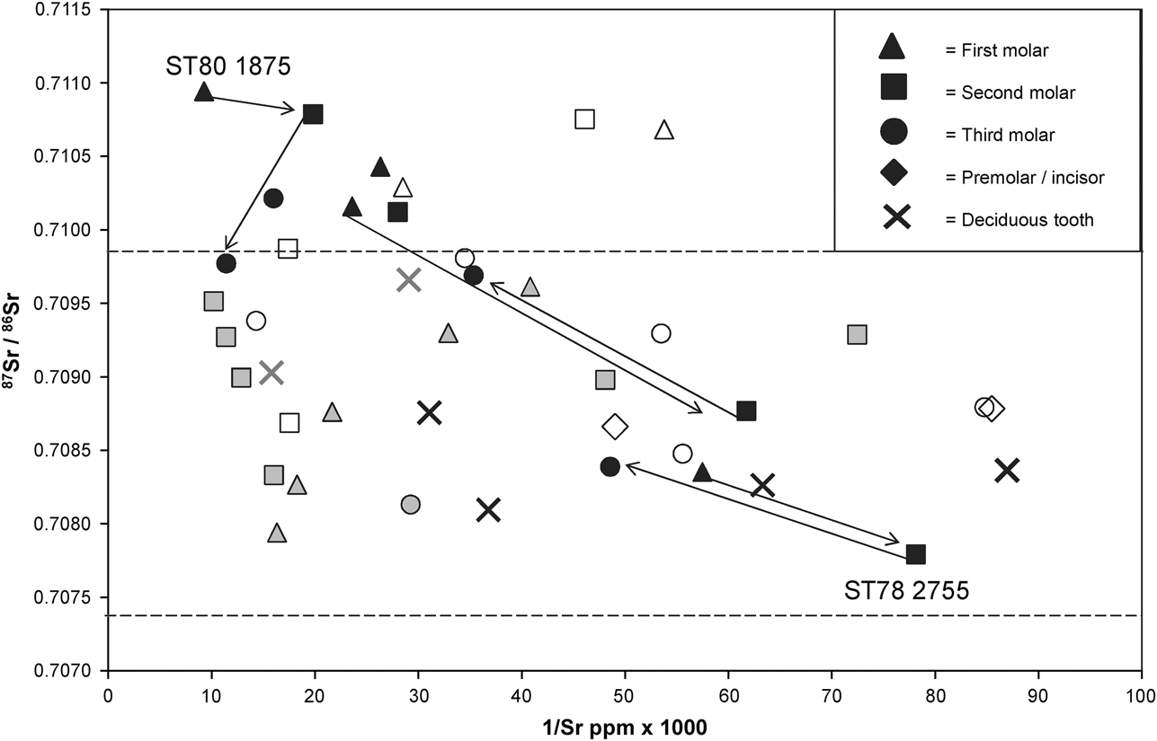
Only five individuals possess at least one tooth with an 87Sr/86Sr value higher than 0.7098. All are adults. Two of these are represented by disarticulated fragmentary remains: individual ST78 1100/ST78 204, who may be female, was excavated from the inner Stepleton outwork (McKinley Reference McKinley2008, 487) and has 87Sr/86Sr values higher than 0.7105 in both their first and second permanent molars. Enamel from the permanent molar of individual HH75 1340, whose fragmentary mandibular remains were found in the inner east cross dyke, gave an 87Sr/86Sr value of 0.71029. The other three are adult males who may have suffered a violent death in the mid–later 36th century bc (ST79 2726, ST81 3181 and ST80 1875; illustrated as black symbols in Figs 3 and 4). Individual ST80 1875, who was found with an arrowhead amongst his ribs, has the highest 87Sr/86Sr values and the highest strontium concentration (>100 ppm) in the sampled burial population, with enamel from both their first and second permanent molar teeth giving strontium isotope ratios higher than 0.7105 (Figs 3 & 4; Mercer & Healy Reference Mercer and Healy2008, 325). In contrast, the fourth adult male, also found in the Stepleton outworks with an arrowhead amongst his ribs but who may have died later in the history of the complex (individual ST78 2755, labelled in Fig. 3; McKinley Reference McKinley2008, 512; Healy et al. Reference Healy, Bayliss, Whittle, Allen, Mercer, Rawlings, Sharples and Thomas2011, 128, 143), has the lowest 87Sr/86Sr value (0.7077) within the sampled population, with enamel from all three permanent molars recording values below 0.7085.
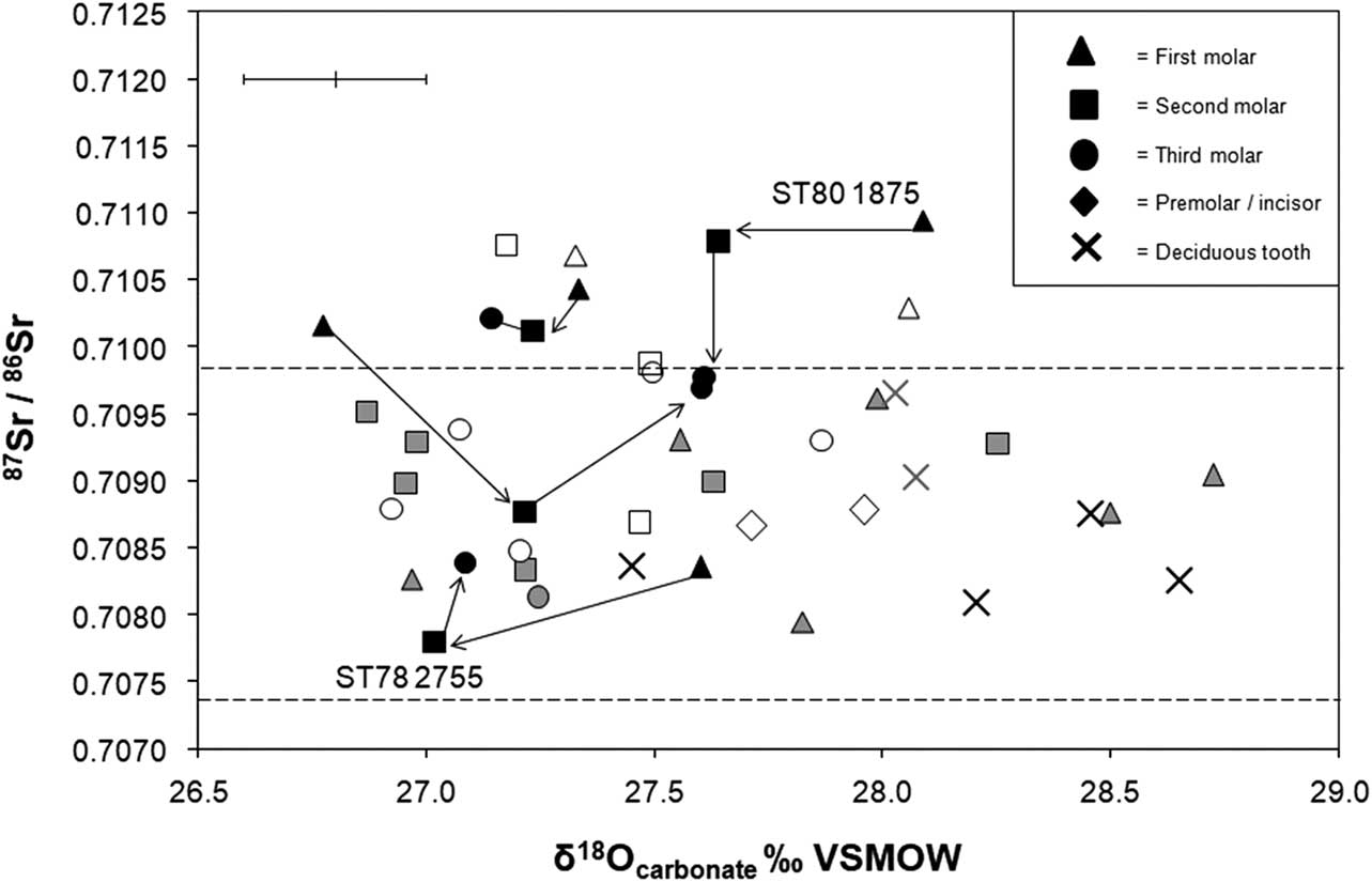
Enamel δ18Ocarbonate values range between 26.8‰ and 28.7‰ (mean 27.6±0.5‰, 1σ, n=43). With the exception of early forming deciduous teeth and first molars which more frequently plot with values that are higher than 28.0‰ (crosses in Fig. 4), the majority of enamel samples gave δ18Ocarbonate values between 27.0‰ and 28.0‰. This range is common amongst sexed males and females (McKinley Reference McKinley2008, 478–9; Table S1) and to both articulated and non-articulated individuals from different contexts, from Stepleton spur, the main enclosure, long barrow and inner east cross dyke. The δ13Ccarbonate values range between –16.8‰ and –14.2‰ (mean 15.9±0.5‰, 1σ, n=43; Table S1). There is no discernible variation in δ13Ccarbonate values with tooth type, with 87Sr/86Sr or δ18Ocarbonate values, or with burial context or sex. All enamel samples from Hambledon Hill fall within the range of values that may be expected for individuals who had a diet dominated by use of C3 terrestrial resources. This is consistent with previous observations based on carbon and nitrogen isotope analysis of bone collagen from this site, which showed that the population also obtained their dietary protein from terrestrial sources (Richards Reference Pryor2000, 128; Reference Richards2008, 524).
DISCUSSION
The presence of artefacts at Hambledon Hill that were manufactured from imported materials originating from at least 40 km away within regions such as Somerset, Devon, and Cornwall, suggests there were long distance connections between the site and the south-west peninsula of England (Smith Reference Smith2008a, 587, 590; 2008b, 630; Darvill Reference Darvill2008, 615; Roe Reference Robertson-Mackay, Butcher, Cameron, Chandra, Conway, Dawes, Dimes, Grigson, Healey, Helbaek and Higgs2008, 632–3; Mercer Reference Mercer2008, 775). However, with the exception of those individuals who may have died during an episode of violence and have more radiogenic 87Sr/86Sr values (close to 0.7105, Fig. 2), most of the burial population do not exhibit strontium isotope ratios consistent with having sourced the majority of their childhood diet from these regions in the south-west.
Rather than routinely exploiting more distant radiogenic terrains, the majority of the sampled burial group have values that fall within locally bioavailable 87Sr/86Sr ranges (Fig. 2; Montgomery et al. Reference Montgomery, Evans and Wildman2006; Evans et al. Reference Evans, Montgomery, Wildman and Boulton2010;Warham Reference Thomas2011). Although alternative areas further afield also afford similar bioavailable 87Sr/86Sr values (see below), a large proportion of the artefact assemblage may originate from lithologies that the causewayed enclosures directly overlook, within approximately 30 km of Hambledon Hill, to the immediate south and west (Smith et al. Reference Smith2008, 645–6; Mercer & Healy Reference Mercer and Healy2008, 767). Individuals who plot with strontium isotope ratios between 0.7086 and 0.7091 have values that are comparable to those recorded on Kimmeridge Clay formation (mean 0.7088±0.0003, 2σ, n=10; Warham Reference Thomas2011: 79). This crops out to the immediate west of the hill and was used to manufacture a large proportion of the pottery deposited within the main enclosure (Smith Reference Smith2008a, 587, 595 –6; Darvill Reference Darvill2008, 620–1). Lithology of Eocene age in southern Dorset (near Wareham, Fig. 2), which could have been the source for much of the worked stone found at Hambledon Hill (Roe Reference Robertson-Mackay, Butcher, Cameron, Chandra, Conway, Dawes, Dimes, Grigson, Healey, Helbaek and Higgs2008, 633; Smith et al. Reference Smith2008, 646), has also been associated with a similar bioavailable 87Sr/86Sr range, approximately 87Sr/86Sr 0.7090–0.7100 (Fig. 2; Evans et al. Reference Evans, Montgomery, Wildman and Boulton2010). Individuals who plot with 87Sr/86Sr values between c. 0.7090 and 0.7100 could therefore have sourced the majority of their diet from either of the immediate areas to the west and south, to which the enclosures are linked through derivation of artefacts.
Few objects made of Chalk or Sarsen were found at Hambledon Hill (Mercer & Healy Reference Mercer and Healy2008, 767; Roe Reference Robertson-Mackay, Butcher, Cameron, Chandra, Conway, Dawes, Dimes, Grigson, Healey, Helbaek and Higgs2008, 633). The excavators therefore suggest that connections between the site and this lithology, to the immediate east, were limited (Fig. 2). However, several individuals within the burial population have low 87Sr/86Sr values that are comparable to those bioavailable on Chalk: in southern Britain this routinely records bioavailable values, between 0.7074 and 0.7087 (mean 0.7080±0.0008, 2σ, n=14; Evans 2010; Warham Reference Thomas2011, 124). Strontium isotope ratios in this range have previously been recorded amongst individuals buried at Monkton-up-Wimborne, on Chalk just to the east in Cranborne Chase, dated later in the 4th millennium bc (Montgomery et al. Reference Montgomery, Budd and Evans2000, 375; Healy et al. Reference Healy, Bayliss, Whittle, Allen, Mercer, Rawlings, Sharples and Thomas2011, 156). The possibility that those individuals buried at Hambledon who have 87Sr/86Sr values below c. 0.7085 obtained their diet from a similar area on the Chalk cannot be ruled out (Figs 2–4), while those who exhibit values up to ~0.7098 may also have obtained their dietary resources from the immediately local Chalk, or Clay-with-flints (see above).
Although samples of plants and water taken on Chalk record low 87Sr/86Sr values, below 0.7085, other marine carbonates such as Oolitic Limestone, Greensand and Gault Formation, which crop out to the west of the hill (Fig. 2) could, alternatively, confer similarly low biosphere values: in southern Britain biosphere samples taken on Oolitic Limestone can record strontium isotope ratios between 0.7076 and 0.7092 (mean 0.7086±0.0004, 1σ, n=17; Montgomery et al. Reference Montgomery, Evans and Wildman2006, 1628; Chenery et al. Reference Chenery, Müldner, Evans, Eckardt and Lewis2010, 155; Warham Reference Thomas2011, 79, 103; for values on Greensand and Gault see Warham Reference Thomas2011, 79). Individuals who exhibit strontium isotope ratios below 0.7085 (Figs 3 & 4) could similarly have obtained their dietary resources on these lithologies. Analysis of the ceramics found at Hambledon suggests that Oolitic Limestone may have been used to manufacture pottery fabric group 2 (Smith Reference Smith2008a, 587, 595–6; Darvill Reference Darvill2008, 615, 617), whilst Greensand was also used to make many of the quern stones (Roe Reference Robertson-Mackay, Butcher, Cameron, Chandra, Conway, Dawes, Dimes, Grigson, Healey, Helbaek and Higgs2008, 632).
Discussion of the range of strontium isotope ratios that the Hambledon burial population exhibit has focused on comparison of 87Sr/86Sr values to bioavailable ranges on lithologies used to manufacture the artefacts. Analysis of material culture provides persuasive evidence for links between Hambledon Hill and more immediate areas of lithology in south-west England. However, the possibility that 87Sr/86Sr values, between 0.7090 and 0.7100, for example, could reflect use of more distant terrains, rather than those within the immediate vicinity of the site, should also be considered.
Strontium isotope ratios between 0.7090 and 0.7100 are widely bioavailable in eastern England, for example (Evans et al Reference Evans, Montgomery, Wildman and Boulton2010), or north-eastern France or the Netherlands (Willmes et al. Reference Whittle, Pollard and Grigson2013; Kootker et al. Reference Kootker, Lanen, van, Kars and Davies2016). The argument that the burial population at Hambledon Hill obtained childhood dietary resources locally from the west of England could be supported by the range of oxygen isotope ratios that this burial population exhibit. If converted to δ18Ophosphate using the equation of Chenery et al. (Reference Chenery, Pashley, Lamb, Sloane and Evans2012), values in second and third permanent molar enamel are in the range 18.0–19.5‰ (mean 18.5±0.4‰, 1σ, n=23), which is close to the mean δ18Ophosphate value that Evans et al. (Reference Evans, Chenery and Montgomery2012, 759) suggest to be representative of analysed burial populations in western (18.2±1‰, 2σ), rather than eastern Britain (17.2±1.3‰, 2σ). However, this assumes that δ18O values in human enamel directly reflect underlying geographical variation in the oxygen isotope composition of drinking waters and that values at Hambledon Hill have not been significantly modified as a result of culinary practice (e.g. Brettell et al. Reference Brettell, Montgomery and Evans2012), or influenced by consumption of fluids that have undergone fractionation through biological processes such as cow’s milk (see above). Deciduous teeth and first permanent molars, which begin to form in utero and continue to form in the months following birth (Hillson Reference Hillson2014, 31, 55–6), were excluded from the above comparisons. As development of these teeth may coincide with breastfeeding it is also possible that values may be influenced by consumption of breast milk, which has a higher δ18O value relative to meteoric water as a result of the metabolic fractionation that occurs in the mother’s body (Roberts et al. Reference Richards, Schulting and Hedges1988, R625; Wright & Schwarcz Reference Willmes, McMorrow, Kinsley, Armstrong, Aubert, Eggins, Falguères, Maureille, Moffat and Grün1998, 13–14; Britton et al. Reference Britton, Fuller, Tütken, Mays and Richards2015, 2). Unlike the majority of second and third permanent molar teeth, many deciduous teeth and first permanent molars in this study exhibit δ18Ocarbonate values that are higher than 28.0‰ (Fig. 4). These early forming teeth also have a higher mean δ18Ophosphate value (19.0±0.6‰, 1σ, n=18), than that of the second and third permanent molars discussed above. There is a drop in δ18O carbonate values between enamel from adjacent permanent first and second molars, illustrated in Figure 5 by a negative difference between the first and second molars, which may also be a consequence of weaning.
Plot of the difference in oxygen (∆ δ18Ocarbonate VSMOW ‰) and strontium (∆ 87Sr/ 86Sr × 1000) isotope ratios between adjacent permanent molar teeth of individuals excavated from the Hambledon Hill complex & Hazleton North long cairn, Gloucestershire (Neil et al. Reference Neil, Evans, Montgomery and Scarre2016). Triangles: the difference in oxygen & strontium isotope ratios between first & second permanent molar teeth. Squares:the difference in oxygen & strontium isotope ratios between second & third permanent molar teeth. 2σ errors for 87Sr/86Sr are within the symbol. Analytical error for δ18Ocarbonate is shown as ±0.2‰ (2σ)
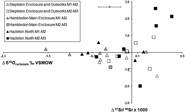
A similar drop in δ18O carbonate values between adjacent permanent first and second molar enamel was also observed amongst another earlier Neolithic burial population, at Hazleton North long cairn, Gloucestershire (Fig. 5; Neil et al. Reference Neil, Evans, Montgomery and Scarre2016). This cairn was constructed in 3710–3655 cal bc (95% probability, OxCal v. 3.5) and the burials there may, therefore, be contemporary with the earliest phase of Neolithic activity at Hambledon Hill (Saville Reference Saville1990; Meadows et al. Reference Meadows, Barclay and Bayliss2007, 54). At Hazleton North, large shifts in 87Sr/86Sr values and elemental concentration between adjacent permanent molar teeth (Fig. 6) are consistent with individuals having routinely changed the geographical location from which they sourced their diet during childhood and support the interpretation that individuals were residentially mobile (Neil et al. Reference Neil, Evans, Montgomery and Scarre2016).
Plot of the difference in strontium isotope ratio (∆ 87Sr/ 86Sr × 1000) and elemental concentration (∆ Sr ppm) between adjacent permanent molar teeth of individuals excavated from the Hambledon Hill complex & Hazleton North long cairn, Gloucestershire. Triangles: the difference in strontium isotope ratio & Sr ppm between first & second permanent molars. Squares: the difference in strontium isotope ratio & Sr ppm between second & third permanent molars. 2σ errors for 87Sr/86Sr are within the symbol
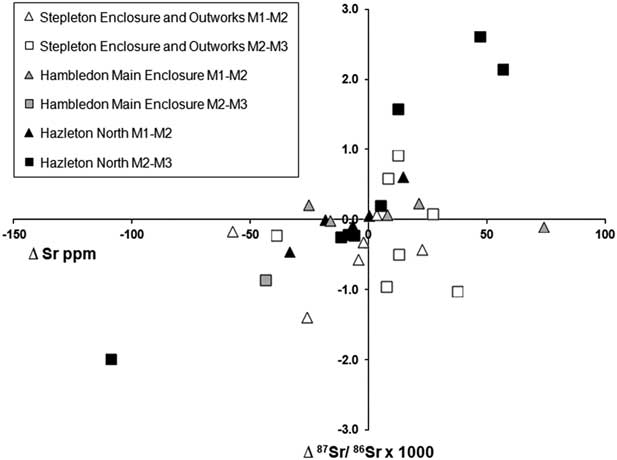
Individuals buried at Hambledon Hill do not exhibit such large shifts in strontium isotope ratio and elemental concentration between sampled adjacent molars (Fig. 6). The majority have similar strontium isotope ratios on adjacent teeth, which could be consistent either with individuals having obtained all their dietary resources from the same locality over a prolonged period during early life, or with exploitation of different, geographically separate areas that conferred a similar averaged 87Sr/86Sr value. For example, enamel samples from all three adjacent molars of individual ST78 2755 gave 87Sr/86Sr values below 0.7085 (labelled on Fig. 3). This individual, who may have met a violent end, died toward the end of the period that the Neolithic monument complex at Hambledon Hill was in use (Healy et al. Reference Healy, Bayliss, Whittle, Allen, Mercer, Rawlings, Sharples and Thomas2011, 128, 143). Similarly low values on all three adjacent molars could suggest that this individual sourced his diet from the same geographical location from birth until about 15 years of age, at which time the crown of the third molar is usually complete (AlQahtani et al. Reference AlQahtani, Hector and Liversidge2010). Alternatively, this individual could have obtained his diet from geographically separate locations that have similar bioavailable 87Sr/86Sr ranges, for example, by moving backward and forward between an area of Oolitic Limestone and the Chalk downs in southern England.
By contrast, the other three adult males who could have died during a previous episode of conflict during the 36th century bc (see above; Mercer & Healy Reference Mercer and Healy2008, 760–1), have the highest 87Sr/86Sr values in the sampled group (black symbols on Figs 3 & 4). These individuals have strontium isotope ratios that are higher than bioavailable ranges currently known to be associated with lithology in the immediate vicinity of Hambledon Hill: all possess at least one permanent molar tooth with an 87Sr/86Sr value greater than 0.7100 which therefore exceed values that are currently known to be bioavailable on immediately local Kimmeridge Clay and Chalk, or on lithology of Eocene age along the south Dorset coast (Fig. 2; Evans et al. Reference Evans, Montgomery, Wildman and Boulton2010; Warham Reference Thomas2011). Two of these individuals (ST79 2726 & ST81 3181) have strontium isotope ratios between 0.7101 and 0.7104 (Table S1). As described above, biosphere 87Sr/86Sr values up to 0.7105 can be recorded on the Peterborough Member of the Oxford Clay in southern Britain (mean 0.7104±0.0001, 2σ, n=4; Warham Reference Thomas2011, 79, 82–3) which crops out just over 8 km to the west of Hambledon Hill (BGS/NERC 2016). As such it is possible that individuals with values up to 0.7105 need not have obtained the majority of their diet a great distance from Hambledon Hill. Alternatively, lithologies further afield within south-western England also record comparable values, for example, samples of plants and water taken on Devonian rocks within Cornwall can give measured values between 0.7100 and 0.7110 (Evans et al. Reference Evans, Montgomery, Wildman and Boulton2010).
The third individual, ST80 1875, who was found with an arrowhead amongst his ribs, has the highest 87Sr/86Sr values of all of those who were sampled (Figs 3 & 4). Enamel samples from both the first and second molar teeth of this individual gave 87Sr/86Sr values greater than 0.7105. According to all currently available 87Sr/86Sr biosphere data, values above 0.7105 are not known to be associated with lithologies of comparable age and composition to those that surround Hambledon Hill (Warham Reference Thomas2011, 79, 82; also see Evans et al. Reference Evans, Montgomery, Wildman and Boulton2010). This individual could not, therefore, have obtained his dietary resources locally but derived his diet from more radiogenic sources further afield until at least 9 years of age, by which stage mineralisation of the crown of the second molar tooth is normally complete (AlQahtani et al. Reference AlQahtani, Hector and Liversidge2010). Although other areas within Britain, or the European mainland, can record bioavailable values higher than 0.7105 (eg Evans et al. Reference Evans, Montgomery, Wildman and Boulton2010; Willmes et al. Reference Whittle, Pollard and Grigson2013), analysis of artefacts provides strong support for the existence of links between this site and lithology in the south-west peninsula (Smith Reference Smith2008a, 590–1; 2008b, 630; Smith et al. Reference Smith2008, 645; Roe Reference Robertson-Mackay, Butcher, Cameron, Chandra, Conway, Dawes, Dimes, Grigson, Healey, Helbaek and Higgs2008, 632–3). Somerset, Devon, and Cornwall in south-western England record bioavailable values higher than 0.7105 and it is possible that this individual obtained dietary resources from these areas during childhood (Montgomery et al. Reference Montgomery, Evans and Wildman2006; Evans et al. Reference Evans, Montgomery, Wildman and Boulton2010).
CONCLUSIONS
Previous analysis of material culture found at Hambledon Hill indicates that a significant proportion of the raw materials used to manufacture ceramics and worked stone may have originated from lithology of Eocene and Upper–Middle Jurassic age, in the more immediate local area which the enclosures overlook to the south and west of the hill, within approximately 30 km (Roe Reference Robertson-Mackay, Butcher, Cameron, Chandra, Conway, Dawes, Dimes, Grigson, Healey, Helbaek and Higgs2008; Darvill Reference Darvill2008; Smith et al. Reference Smith2008). The excavators therefore suggested that the immediate area of landscape visible from each enclosure provides an approximate index of the catchment which was occupied by the communities who used the site (Mercer & Healy Reference Mercer and Healy2008, 767; Healy Reference Healy2004, 31). Whilst other areas have been considered that could provide comparable isotope ratios, the majority of the sampled group exhibit values that could be consistent with this hypothesis. Longer distance connections, between Hambledon Hill and areas further afield within the south-west peninsula of England, are implied by the presence of objects that could originate from lithology within Somerset, Devon, and Cornwall (Roe Reference Robertson-Mackay, Butcher, Cameron, Chandra, Conway, Dawes, Dimes, Grigson, Healey, Helbaek and Higgs2008; Smith et al. Reference Smith2008). However, few of the individuals in the sampled group have 87Sr/86Sr values that would be consistent with having obtained the majority of their diet from these regions during childhood and adolescence. The individuals who have the highest values in the sampled group are those who the excavators suggest died during one or more episodes of conflict, which involved burning and destruction of outworks that surround the hill, during the 36th century bc (Mercer & Healy Reference Mercer and Healy2008; Healy et al. Reference Healy, Bayliss, Whittle, Allen, Mercer, Rawlings, Sharples and Thomas2011). At least one of these adult males could not have sourced his childhood diet locally. This individual, who was found within the outworks that surround the site with an arrowhead amongst his ribs, obtained his diet from further afield during early life. The individual has 87Sr/86Sr values that are consistent with those bioavailable within Somerset, Devon and Cornwall within the south-west peninsula of England, the area from which previous analysis of material culture suggests that artefacts were imported.
Acknowledgements
We would particularly like to thank Hilary Sloane (NERC Isotope Geosciences Laboratory) for analytical support; Professor Roger Mercer for discussion of the excavation and provision of figure 1; Jon Murden and Richard Breward for permission to undertake sampling and the exceptional team of volunteers at Dorset County Museum for facilitating access to the museum collections. S.N. and J.E. undertook the analysis; S.N. wrote the paper. All authors discussed the manuscript. S.N. designed the research; laboratory analysis was funded through NIGFSC grant IP‐1290‐0512; S.N. was funded through a Durham University Doctoral Studentship award.
SUPPLEMENTARY MATERIAL
To view the supplementary material for this article, please visit https://doi.org/10.1017/ppr.2018.6


 Open access