

Introduction
Land and water resources degradation remains one of the major global threats. It is negatively impacting livelihoods and returns from large-scale development activities [e.g., sedimentation of water infrastructure (Obalum et al., Reference Obalum, Mohammed, Nwite, Watanabe, Igwe and Wakatsuki2012)] in most African countries. Recent estimates put the extent of degraded land in Ethiopia at more than a quarter of the area of the country. This affects nearly a third of the population (Chirwa, Reference Chirwa2014; Gebreselassie et al., Reference Gebreselassie, Kirui, Mirzabaev, Nkonya, Mirzabaev and von Braun2016). Depending on the type of land cover and the method of estimation, the average rate of soil erosion in the Ethiopian highlands ranges from 6 to 33 tons ha−1 yr−1 (Hurni et al., Reference Hurni, Zeleke, Kassie, Tegegne, Kassawmar, Teferi, Moges, Tadesse, Ahmed, Degu, Kebebew, Hodel, Amdihun, Mekuriaw, Debele, Deichert and Hurni2015). The total estimated loss of fertile topsoil in the highlands of Ethiopia varies between 941 million tons and 1.5 billion tons per year (Tamene and Vlek, Reference Tamene, Vlek, Braimoh and Vlek2008; Hurni et al., Reference Hurni, Zeleke, Kassie, Tegegne, Kassawmar, Teferi, Moges, Tadesse, Ahmed, Degu, Kebebew, Hodel, Amdihun, Mekuriaw, Debele, Deichert and Hurni2015). UNDP (2002) has estimated nutrient depletion as a result of soil loss at 30 kg ha−1 yr−1 of nitrogen and 15–20 kg ha−1 yr−1 of phosphorus. Such massive soil movement has on-site and off-site impacts.
The main causes of land and water degradation are complex and interactive. They include deforestation, soil erosion, agricultural land expansion and overgrazing (Tekle, Reference Tekle1999; Paulos, Reference Paulos2001; Nyssen et al., Reference Nyssen, Poesen, Moeyersons, Deckers, Mitiku and Lang2004; Hurni et al., Reference Hurni, Tato and Zeleke2005; Yirga and Hassan, Reference Yirga and Hassan2010; Adimassu et al., Reference Adimassu, Langan, Johnston, Mekuria and Amede2017), as well as underlying drivers such as weak regulatory frameworks and institutions, demographic growth, unclear land-use rights, low empowerment of local communities and poverty (Haileslassie et al., Reference Haileslassie, Priess, Veldkamp, Teketay and Lesschen2005; Kirui and Mirzabaev, Reference Kirui and Mirzabaev2014). In Ethiopia, the direct cost of soil and essential nutrient loss due to unsustainable land management was estimated in 1994 (Bojo and Cassels, Reference Bojo and Cassels1995) at 3% (US$106 million) of the agricultural GDP. A recent modeling study by Sonneveld (Reference Sonneveld2002) estimated that the loss of agricultural value during the period 2000–2010 was about US$7 billion. A more recent study indicated that the annual cost of land degradation associated with land use and land cover change in Ethiopia is about US$4.3 billion (Gebreselassie et al., Reference Gebreselassie, Kirui, Mirzabaev, Nkonya, Mirzabaev and von Braun2016). To address this problem, we need integrated actions covering different landscapes and involving various stakeholders (Pistorius et al., Reference Pistorius, Carodenuto and Wathum2016). The government of Ethiopia, in collaboration with local and international communities, has been implementing several forms of land and water management interventions (Humphrey, Reference Humphrey1999; Tamene and Vlek, Reference Tamene, Vlek, Braimoh and Vlek2008; Merrey and Gebreselassie, Reference Merrey and Gebreselassie2011). These interventions include construction of soil and water conservation structures, afforestation and establishment of exclosures in degraded landscapes. The Ethiopian government's voluntary commitment in the context of the Bonn Challenge to restore 15 million ha of degraded land is part of these efforts. In the context of rural Ethiopia, exclosure-based forest establishment and ecosystem service restoration provides a promising approach to reversing the widespread land degradation and supporting the livelihood expectations of millions of smallholder farmers.
Exclosures are areas fenced off from anthropogenic interventions such as wood harvesting, grazing by livestock and other agricultural activities with the objective of allowing natural regeneration of vegetation and restoration of degraded communal grazing lands and other suitable land cover and land use types (Mekuria et al., Reference Mekuria, Veldkamp, Mesfin and Olschewski2011a). In Ethiopia, establishment of exclosures started in the northern highlands four to five decades ago (Mekuria and Aynekulu, Reference Mekuria and Aynekulu2013).
This practice can also be applied to sensitive ecosystems (hillside forest stands) to limit anthropogenic interventions. It can be implemented in wetlands, around river or buffer areas as well as in degraded grazing and agricultural lands. Establishment of exclosures incurs less cost compared to other land restoration interventions such as bunds and terraces. It has its pros and cons (Adimassu et al., Reference Adimassu, Langan, Johnston, Mekuria and Amede2017). The most commonly cited opportunity costs of exclosures include decrease in communal grazing lands and curtailed availability of and access to fuelwood (Mekuria et al., Reference Mekuria, Veldkamp, Corre and Mitiku2011b, Reference Mekuria, Langan, Johnston, Belay, Amare, Gashaw, Desta, Noble and Wale2015; Mekuria and Aynekulu, Reference Mekuria and Aynekulu2013; Adimassu et al., Reference Adimassu, Langan, Johnston, Mekuria and Amede2017). Nevertheless, some of these opportunity costs can be minimized though integrating income-generating activities (e.g., apiaries) within exclosures (Adimassu et al., Reference Adimassu, Langan, Johnston, Mekuria and Amede2017; Mekuria et al., Reference Mekuria, Barron, Dessalegn, Adimassu, Amare and Wondie2017).
Scaling of exclosure-based ecosystem restoration in Ethiopia is constrained by several factors including the lack of a countrywide prioritization and targeting tool and a management plan following the establishment of an exclosure. The lack of incentives for forgoing limited short-term economic benefits is another complaint heard from local communities (Mekuria et al., Reference Mekuria, Barron, Dessalegn, Adimassu, Amare and Wondie2017).
Geographic Information System (GIS) tools can be applied to develop a framework to support the targeting of appropriate areas for various interventions. Multicriteria analyses too are appropriate for land suitability assessment (Venkatesan et al., Reference Venkatesan, Krishnaveni, Karunakaran and Ravikumar2010; Worqlul et al., Reference Worqlul, Collick, Rossiter, Langan and Steenhuis2015; Akyol et al., Reference Akyol, Kaya and Alkan2016; Worqlul et al., Reference Worqlul, Jeong, Dile, Osorio, Schmitter, Gerik, Srinivasan and Clark2017; Schmitter et al., Reference Schmitter, Kibret, Lefore and Barron2018). However, there has been limited application of a multicriteria framework to identify and target potential exclosure areas in Ethiopia. The objectives of this study therefore were: (i) to develop a GIS-based multicriteria decision-support tool that helps us to identify suitable areas with potential for exclosure-based ecosystem service restoration; (ii) to provide spatially explicit information on potential exclosure areas disaggregated by river basin and agroecology and (iii) to conduct an ex-ante analysis of the potential of exclosure areas for improving ecosystem services in terms of an increase in above-ground biomass (AGB) production and carbon storage.
The current study has multiple benefits: first, the tool we developed from this study can be applied elsewhere to out-scale exclosure. The methodology relies on open source software and open license data sources, which allows users to improve the tool. Secondly, information generated through this study could support planning, implementation, monitoring and evaluation of land restoration through exclosures. For instance, it can support ongoing efforts to sustain the benefits of water infrastructure (e.g., hydropower dams) by providing information on priority areas for establishing exclosures and help in the protection of man-made and natural water bodies from erosion and sedimentation. This study also attempts to provide information on changes in the above-ground carbon stock following the establishment of exclosures. Therefore, programs such as REDD+ (Reduction of Emission from Deforestation and Degradation) and Ethiopia's voluntary commitment to the Bonn Challenge and the project to plant 4 billion trees could benefit from this study.
Materials and methods
Study area and selection of validation points
This study focused on Ethiopia at multiple but interactive scales. The overall analysis was done at the national level and disaggregated for the 11 river basins of the country (Fig. 1A). Further, two sample basins were selected and disaggregated by agroecology (Fig. 1B). At the lower end of the scale were three microwatersheds nested into the two sample basins and used for validation (note the dots in Fig. 1B).
Location of the study areas and their multiple spatial scales: (A) the river basins of Ethiopia and their agroecologies; (B) Abay river basin and validation points and (C) Rift Valley lakes basin and validation points.

Overall, we followed a two-step procedure to validate the analyses. First, we selected two basins: the Abay River and the Rift Valley lakes basins (Fig. 1B and C). The key criteria we used to select the two basins included: (i) severity of land degradation and sedimentation of water bodies; (ii) the presence of large-scale development interventions (e.g., irrigation and hydropower developments); (iii) availability of diverse agroecological zones and ecosystem sensitivity to disturbance and (iv) potential for future development (McCartney and Girma, Reference McCartney and Girma2012; Haregeweyn et al., Reference Haregeweyn, Tsunekawa, Tsubo, Meshesha, Adgo, Poesen and Schütt2016). Secondly, we selected three sample watersheds, the Koga, Gumera and Hawassa-Zeway lake watersheds (Fig. 1B and C), in the two basins for validation. The key criterion for selecting these watersheds was the presence of heterogeneous biophysical settings where exclosures have been implemented. A total of 385 ground truthing points were set up across the three watersheds.
General procedure
We developed a spatial analysis procedure using the GIS-based Multi Criteria Decision Analysis (MCDA) method to determine potential areas for exclosure establishment. The framework was used to estimate land suitability for scaling exclosures across scale in Ethiopia. The MCDA method enables us to structure decision problems and design, evaluate and prioritize alternative scenarios or decisions (Malczewski, Reference Malczewski2006; Worqlul et al., Reference Worqlul, Collick, Rossiter, Langan and Steenhuis2015; Worqlul et al., Reference Worqlul, Jeong, Dile, Osorio, Schmitter, Gerik, Srinivasan and Clark2017; Schmitter et al., Reference Schmitter, Kibret, Lefore and Barron2018). MCDA also enables us to combine geographical data and value judgments (the decision-maker's preferences) to obtain information for decision-making (Malczewski, Reference Malczewski2006).
The applied procedure involves seven steps (Fig. 2): (i) definition of the conceptual framework; (ii) assigning a score/rank to each factor (Fig. 2B); (iii) creation of a constraint layer (Fig. 2A); (iv) integration of thematic layers and spatial models (Fig. 2B); (v) validation of suitability mapping; (vi) overlay of the identified suitable areas on the actual land-use map to determine suitability in agricultural and non-agricultural land-use areas (Fig. 2C) and (vii) aggregation of suitability within river basins and disaggregation by agroecology (Fig. 2C). These steps are elaborated upon in the following sections.
The framework for GIS-based MCDA applied to map land suitable for exclosure-based ecosystem service restoration.

Conceptual framework
To determine the suitability factors to aid us in identifying potential land for exclosures, we explored two scenarios based on: (i) the Food and Agriculture Organization [FAO (Sheng, Reference Sheng1990)] exclosure suitability criteria and (ii) the land-use policy of the Federal Democratic Republic of Ethiopia [FDRE (MoA, 2016)]. In both scenarios, the variables considered in the framework included slope, soil depth, biomass and proximity to wetlands (streams and lakes).
The criteria for suitability of land for exclosures vary as per FAO (Sheng, Reference Sheng1990) and FDRE (MoA, 2016) guidelines. According to the FAO criteria, areas with a slope above 46%, independent of land-use type, are suitable for establishing exclosures whereas the FDRE land-use policy suggests that degraded areas with a slope >50% are suitable. According to FAO, agricultural lands with a soil depth of 0–20 cm are suitable for establishing exclosures while the FDRE guidelines set this value at 0–25 cm.
With sedimentation and pollution posing an increasing threat to lakes and rivers, the Ethiopian River Basin Development Authority has launched several initiatives to delineate buffer zones around wetlands and put them under exclosures while investing in enrichment planting. Bekele-Tesemma et al. (Reference Bekele-Tesemma, Birnie and Tengnäs1993) define and suggest attributes to delineate areas with low biomass potential (Bereha). The key attribute to define these areas could be long-term biomass productivity. In this study, we applied the time series vegetation index [enhanced vegetation index (EVI)] to detect areas with long-term low biomass productivity. The following subsections provide details of the ranking of each of the factors used in the framework.
Assigning scores/ranks to each factor
The data identified and acquired for the analysis need to be reclassified so that they have the same range of values (Saaty, Reference Saaty1977; Schmitter et al., Reference Schmitter, Kibret, Lefore and Barron2018). Accordingly, we classified each data layer as per a scale of 1–5, with 5 being the most suitable environment for exclosure land use and 1 being the least suitable (Table 1). Ranking of classes within each factor was done on the basis of literature review (Sheng, Reference Sheng1990; MoA, 2016) and expert opinion. The ranking/reclassifying of values in each factor was done independent of the other factors. Figure 2B shows the factors that were included and reclassified. These were slope, soil depth, biomass, proximity to water bodies (streams and lakes).
(A) Slope: Slope is one of the factors that govern runoff and soil erosion and directly influence the infiltration of rain water. The relationship between runoff and sediment yield and steepness of the slope is well-established (Haileslassie et al., Reference Haileslassie, Priess, Veldkamp, Teketay and Lesschen2005; Hurni et al., Reference Hurni, Zeleke, Kassie, Tegegne, Kassawmar, Teferi, Moges, Tadesse, Ahmed, Degu, Kebebew, Hodel, Amdihun, Mekuriaw, Debele, Deichert and Hurni2015). Runoff volume and sediment yield are higher in sloping terrain than in flat terrain (Hurni et al., Reference Hurni, Zeleke, Kassie, Tegegne, Kassawmar, Teferi, Moges, Tadesse, Ahmed, Degu, Kebebew, Hodel, Amdihun, Mekuriaw, Debele, Deichert and Hurni2015). A digital elevation model (DEM) with 30 m resolution from Earth Explorer web portal (http://earthexplorer.usgs.gov/) was used to derive a slope layer (in percentage.) A score of 5 was given to a steep slope because higher runoff contributes to higher erosion. According to the FAO (Sheng, Reference Sheng1990), areas with a slope >46%, regardless of the land-use type, are suitable for exclosures whereas the FDRE land-use policy suggests a slope >50% (Table 1).
(B) Soil depth: The depth of soil determines the use of land for a specific purpose: it limits the root depth and influences the drainage pattern. The shallower the soil, the less its capacity to store water, rendering it more prone to degradation. Implicitly, such land has to be put under exclosure and ecosystem service restoration. In this study, the soil depth layer was created from depth to bedrock with 250 m resolution as per the International Soil Reference and Information Centre [ISRIC (Hengl et al., Reference Hengl, Heuvelink, Kempen, Leenaars, Walsh, Shepherd, Sila, MacMillan, Mendes de Jesus, Tamene and Tondoh2015)]. According to the FAO-based scenario (Sheng, Reference Sheng1990), areas with a soil depth of 0–20 cm are suitable for exclosure land use while the FDRE land-use policy recommends a soil depth of 0–25 cm. In both scenarios, a score of 5 was assigned to shallow soil and a score of 1 to deep soil (Table 1).
(C) Enhanced Vegetation Index (EVI): The EVI composite was used from MODIS Terra and Aqua at 16 composite days with 250 m resolution from 2002 to 2016. The average and coefficient of variation of EVI were calculated in Google Earth Engine (GEE). Ranking of degradation levels was done using the long-term mean annual Enhanced Vegetation Index (EVIavg) and coefficient of variation of long-term Enhanced Vegetation Index (EVIcv) as a proxy for deriving the degradation levels of different landscapes. Accordingly, using the above criteria, landscapes were classified into four classes. For this purpose, training samples were collected from four types of landscapes: (a) area with very high EVIavg and low EVIcv; (b) areas with high EVIavg and high EVIcv; (c) areas with low EVIavg and low EVIcv and (d) areas with low EVIavg and high EVIcv. The sites were selected on the basis of historical Emergency Needs Assessment reports from 2002 to 2012 (DRMFSS and MoA, 2012) and Google Earth high-resolution satellite imagery. Areas with low EVI average were assigned a score of 5 since these areas have low biomass production compared with high EVI average areas, which received a score of 2 (Table 1).
(D) Proximity to water bodies: The DEM was used to derive the stream network. Once the streams were derived, a layer showing the distance to stream was created. The distance to stream layer was reclassified into two classes: 0–30 m and above 30 m. A score of 5 was assigned to areas close to a stream, assuming that these areas are prone to erosion and needing protection. Areas far from the river were assigned a score of 2 (Table 1).
Reclassification criteria used for the various factors included in the MCDA under the national land use policy FDRE (MoA, 2016) and FAO (Sheng, Reference Sheng1990) scenarios

Lakes and reservoirs are affected by the human activities occurring around them. First, the water bodies layer was created from a land cover map released by the European Space Agency (Ramoino et al., Reference Ramoino, Pera and Arino2016). This map, available for free, was created using Sentinel-2. The second layer created was a water occurrence layer based on images available since 1984 showing areas occurring from 0 to 100 of the observation periods and derived in GEE. This layer provided spatial information on water bodies. The water bodies layer from Sentinel-2 land cover and the water occurrence layer from GEE were merged into a single layer. This was then used to create the distance to lakes layer and reclassified into four classes: 0–150, 150–180, 180–8000 and greater than 8000 m. The areas close to lakes were assumed to contribute to sedimentation if not protected; and those areas far from lakes were taken to have less influence on sedimentation of lakes. Therefore, areas close to the lakes were assigned a score of 5 (Table 1).
Constraint layer
Naturally, there are areas where exclosure cannot be practised: for example, water bodies, extreme cold areas and extreme desert areas. Therefore, constraint factors, as illustrated in Table 1, were defined. A constraint layer was created for exclosure-unsuitable lands in agroecological zones, lakes and built-up areas (Fig. 2A).
The input data for deriving the agroecological zones in this study were the 1 arcsecond scenes of the Space Shuttle Radar Topography Mission (SRTM), the DEM covering Ethiopia and the mean WorldClim rainfall data at 900 m resolution (http://www.worldclim.org/). A total of 95 1 arcsecond scenes DEM were merged to derive a DEM covering the whole of Ethiopia. Two agroecological zones were identified as not suitable for agricultural land use (Bekele-Tesemma et al., Reference Bekele-Tesemma, Birnie and Tengnäs1993): (a) areas below 500 m a.s.l. with precipitation less than 900 mm where rainfed agriculture is not possible (desert); and (b) areas too cold regardless of the amount of rainfall (frost above 3700 m a.s.l.). Table 2 shows the different agro-ecological zones of Ethiopia based on rainfall and elevation as indicated in Bekele-Tesemma et al. (Reference Bekele-Tesemma, Birnie and Tengnäs1993). Areas falling within the two classes were excluded from suitability analysis. Also, areas with a long-term EVI average below 0.15 were excluded as productive land-use practices are not practical there due to a combination of land- and weather-related factors.
Different agro-ecological zones of Ethiopia based on rainfall and elevation according to Bekele-Tesemma et al. (Reference Bekele-Tesemma, Birnie and Tengnäs1993). Gray highlighted are zones excluded from suitability analysis
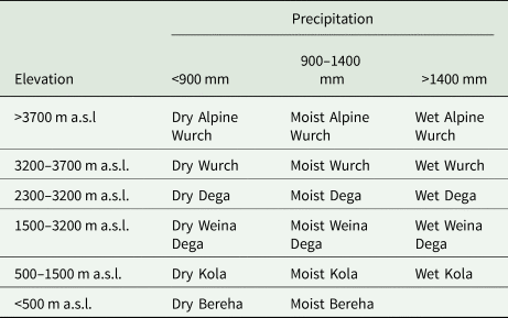
Wurch = frost, Dega = highland, Weina Dega = mid-highland, kola = lowland and Berha = desert.
Built-up areas are supposed to be excluded from the analysis. To derive the town layer, the National Oceanic and Atmospheric Administration (NOAA) Night Light data were used. The NOAA data were acquired in GEE with 4 km resolution (Gorelick et al., Reference Gorelick, Hancher, Dixon, Ilyushchenko, Thau and Moore2017). This and the slope layer (<15%) were used to derive a built-up constraint layer. Water bodies by themselves are assumed to be not directly under exclosure areas. Therefore, lakes and reservoirs were considered as a constraint layer. This constraint layer was created from the Sentinel-2 land cover and GEE water occurrence layer. All the individual constraint layers were then merged to create a single layer excluding areas falling in any one of the several constraints.
Integration of thematic layers and spatial model
Integration of the reclassified layers was done in three steps: (i) weighting each reclassified factor; (ii) merging the factors by applying the weights and (iii) reclassifying the result of the weighted overlay and merging steps. It is evident that the suitability and constraint factors being considered have varied degrees of influence and importance in determining exclosure suitability. Thus, defining weights is crucial for detecting the importance or preference of each factor relative to the others (Saaty, Reference Saaty1980). Accordingly, we transformed all the factors into similar units, and used pairwise comparisons to determine the weights of each factor relative to the other factors (Saaty, Reference Saaty1980). We used a standard scale with values 1–7 to determine the weight of each factor. This was done for each scenario resulting in two outputs, one for each scenario based on two scenarios, one based on FAO criteria (Sheng, Reference Sheng1990) and the other on FDRE (MoA, 2016) criteria. Weighting of the factors was applied in two parts. The first part considered the reclassified factors of slope, soil depth and biomass with weights of 0.6, 0.2 and 0.2, respectively (Table 3). The second part considered the reclassified factors of proximity to water bodies and degraded wetland, slope and biomass by applying weights of 0.6, 0.2 and 0.2, respectively.
Factors average weigh and consistency measure for the suitability analysis following a pairwise comparison

SD, soil depth; SL, slope (steepness); PL, proximity to water bodies; BC, biomass class.
The reclassified factors were then merged by applying the weights assigned to each class. This was done for the first and second parts separately. Applying the weights in the first part produced the aggregated layer WFS1 using the reclassified factors (RF) of slope, soil depth and biomass with weights (FW) of 0.6, 0.2 and 0.2, respectively, as illustrated by Equation (1):
 $${\rm W}{\rm F}_{{\rm S1}} = \sum {{\rm RF}} \times {\rm F}_{\rm W}$$
Applying the weights in the second part produced the aggregated layer WFS2 using the reclassified factors (RF) of proximity to water bodies and degraded wetland, slope and biomass with weights (FW) of 0.6, 0.2 and 0.2, respectively, as illustrated by Equation (2):
 $${\rm W}{\rm F}_{{\rm S2}} = \sum {{\rm RF}} \times {\rm F}_{\rm W}$$
WFS1 and WFS2 were merged to produce a single thematic layer by taking the maximum of the values from the two layers. The output layer can have decimal values between 5 and 0. It is not possible to estimate area coverage of the different classes using decimal values. As a result, potential areas for exclosures following the multicriteria model were further reclassified into three classes: very highly suitable (>4.5), highly suitable (4.5 to 4) and suitable (4 to 3.5). Areas with a score below 3.5 were excluded from analysis as establishing exclosures in those areas is not possible or productive (Fig. 1B).
Land-use adjustment to conservation measures
We conducted land-use adjustment analysis in relation to the proposed suitability classes by overlaying a present land-use layer on the suitability maps produced for each of the two scenarios (Fig. 2C). The present land-use layer was created using the Sentinel-2 land cover (Ramoino et al., Reference Ramoino, Pera and Arino2016) and agricultural land cover (IWMI, 2015). The outputs generated by this step indicate whether the land identified as suitable for exclosure corresponds to current degraded agricultural land or to current natural or perennial vegetation. Such analyses provide support to practitioners or land managers to make informed decisions on future land use and the adjustments needed. It helps also to understand the potential tradeoffs and mitigation measures needed as well as the need to implement land restoration interventions. In this regard the key challenge is that the current land-use map aggregates agricultural land but does not separate grazing and crop areas. Therefore, this study does not address the specific competition or tradeoff between land conversion to exclosure and other agricultural land-use types.
Validation of the suitability mapping
As indicated earlier, a two-step procedure was followed to validate the analyses. First, we selected two basins—the Rift Valley lakes and Abay River basins (Fig. 1)—and nested therein three sample watersheds for validation: Koga and Gumera in the Abay basin and the Hawassa-Zeway lakes in the central Rift Valley lakes basin (Fig. 1B and C). The suitability mapping analysis was validated using ground truthing and recent high-resolution images from Google Earth. The information we collected included the presence of existing exclosures, agricultural land-use data, slope, status of land degradation, soil depth and proximity to water bodies. The current land-use type was observed for each point on Google Earth imagery, which showed detailed features around the selected points. The slope of each point was obtained from the DEM at 30 m resolution. Field data were collected from accessible areas in the three selected watersheds which included a total of 385 ground truthing points (253 in Hawassa-Zeway and 132 in Koga and Gumera). Compilation of the survey data from each ground truthing point provided information on: (a) exclosure suitability as per field observations and (b) exclosure suitability according to the suitability map. The surveyed points were assigned a suitability class value corresponding to the classes of the multicriteria model 5 indicating suitability or 1 non-suitability for exclosure-based intervention. Accuracy assessment was done for each of the two scenarios (FDRE and FAO) using the observations and the corresponding map values. The overall accuracy was calculated by dividing the sum of the suitability class matching samples by the total number of sample points (Liu et al., Reference Liu, Frazier and Kumar2007). Accordingly, the validation analyses conducted in the two basins indicated a suitability class accuracy of 90% for the FDRE scenario and 95% for the FAO scenario (Table 4).
Field observation vs model suitability for the FDRE and FAO based scenarios (suitability and unsuitability agreement in number; total sample number = 385; producer's, user's and over all accuracy in %)

Ex-ante analysis of above-ground biomass and carbon stocks
The potential accumulation of AGB is one of the ecosystem services that exclosure-based land restoration promises. In this study, we estimated this ecosystem benefit using Ethiopia's Forest Reference Level (EFRL) submission to the UNFCCC 2017 (MEFCC, 2017). The suitability map of exclosures was overlaid on the biome and agroecology map of Ethiopia to derive the area coverage of exclosures in different biomes and agroecologies. The biome data classify the country into biomes including Acacia-Commiphora, Combretum-Terminalia, Dry Afromontaine, Moist Afromontaine and Other (water bodies). The area coverage of exclosures in each biome was multiplied with the EFRL (tons ha−1) to derive the AGB in tons. The coverage considered only the very highly and highly suitable exclosure areas. Carbon stock was estimated by multiplying the estimated AGB by a carbon fraction of 0.47. A carbon fraction of 0.47 has been applied in Ethiopia, which is the default value for wood in the tropical and subtropical domains (MEFCC, 2017).
Results
Values and spatial distribution of land found suitable for exclosure-based ecosystem service restoration
Table 5 and Figure 3 show the empirical values and spatial distribution of land found to be suitable for exclosure-based ecosystem service restoration under the FDRE-based (MoA, 2016) and FAO-based (Sheng, Reference Sheng1990) scenarios. Except for the lowlands in the northeastern, eastern and southeastern parts of Ethiopia, most of the areas were suitable for exclosures, in particular the central, northern, eastern and southern highlands, which were found to be highly suitable. The total estimated potential land was 9 million ha for the FDRE-based scenario and about 11 million ha for the FAO-based scenario. This is equivalent to 8 and 10% of Ethiopia's surface area under the two scenarios, respectively.
Spatial distribution of land found to be suitable for exclosure-based ecosystem service restoration under two scenarios: (a) FDRE (MoA, 2016) and (b) FAO (Sheng, Reference Sheng1990). The white areas are either constraints or areas not suitable for exclosure measures.

Estimated area of land suitable for exclosure-based ecosystem service restoration under two scenarios in eleven basins of Ethiopia
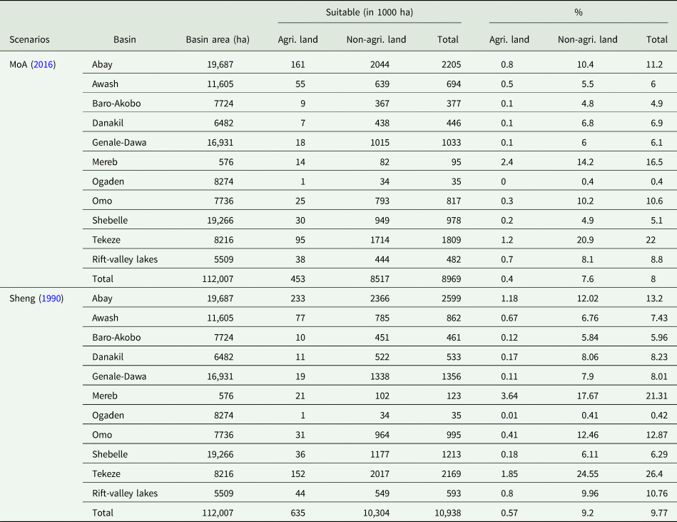
The % is calculated in relation to respective river basin areas.
Table 5 also shows data on enclosure-suitable areas that are currently under agricultural and non-agricultural activities. For example, as per the FDRE (MoA, 2016) scenario, 0.45 million ha of the suitable land are currently under agriculture. That is 0.4% of Ethiopia's land area. Of this, 0.08 million ha are classified as very highly suitable and 0.37 million ha as highly suitable for exclosures. Under the FAO-based (Sheng, Reference Sheng1990) scenario, about 0.64 million ha (0.57% of Ethiopia's land area) of the potential land are currently under agriculture. A significant proportion of the land, however, is under non-agricultural land use, including degraded lands or bush land, which have relatively lower opportunity costs when converted to exclosure compared to agricultural land. These non-agricultural lands found suitable for exclosure are distributed around the western and eastern parts of the country (Fig. 3).
Values and spatial distribution of enclosure-suitable land by river basins
Table 5 presents data on suitability of land for exclosure-based interventions in the major river basins of Ethiopia. Table 6 disaggregates the same attributes by agroecology for the Abay and Rift Valley basins. Figures 4 and 5 show the spatial distribution of this land in these two basins respectively. The major purpose of this exercise was to assess the extent of area that is suitable for exclosure-based ecosystem service restoration in the river basins and to prioritize these areas for investment to protect water infrastructure (such as hydropower reservoirs) from sedimentation. The results demonstrated that the Tekeze, Rift Valley, Mereb and Abay river basins contain the largest proportion of area suitable for exclosure (Table 5). Based on the FDRE (MoA, 2016) scenario, the Abay river basin showed a potential of about 2.2 million ha of land (11.2% of the basin area) that is suitable for exclosure-based ecosystem service restoration, whereas the Tekeze river basin contains about 1.8 million ha (22% of the basin area). The second scenario, based on FAO (Sheng, Reference Sheng1990), demonstrated a similar trend but with slightly different values across the river basins.
Spatial distribution of land suitable for exclosure-based ecosystem service restoration in Abay river basins under two scenarios: (a) FDRE (MoA, 2016) and (b) FAO (Sheng, Reference Sheng1990). The white areas are either constraints or areas not suitable for conservation measures.

Spatial distribution of land suitable for exclosure-based ecosystem service restoration in Ethiopia's Central Rift Valley basin under two scenarios: (a) FDRE (MoA, 2016) and (b) FAO (Sheng, Reference Sheng1990). The white areas are either constraints or areas not suitable for conservation measures.

Estimated area of land suitable for exclosure-based ecosystem service restoration under two scenarios in Abay and central rift valley basins of Ethiopia disaggregated by agroecology

A major part of the area in the Abay basin that was found to be suitable for exclosure is not currently under agricultural land use (Table 5). The Moist Mid-highland and Moist Highland agroecological zones host major parcels of land suitable for exclosure-based ecosystem service restoration (Table 6).
In the central Rift Valley basin, a total of 61.8 × 10³ and 69.8 × 10³ ha of land were estimated to be suitable for exclosure under the FDRE-based (MoA, 2016) and FAO-based (Sheng, Reference Sheng1990) scenarios, respectively (Table 5). However, a considerable proportion of this area is currently under agricultural land use (Table 6; Fig. 5). For example, based on the MoA (2016) scenario, 19.4 × 10³ ha of land (32% of the basin area) and 20.8 × 10³ ha of land (30% of the basin area) based on the Sheng (Reference Sheng1990) scenario are currently under agricultural land use. This contrasts with the Abay basin where most of the suitable land is under non-agricultural land use. The Rift Valley lake basin has relatively fewer agroecological zones; only subtle differences were observed among these different zones in terms of suitability for exclosure interventions.
Discussion
Decision-support tools to target and prioritize exclosure-based interventions can help countries in delivering their commitments
In the context of the Bonn Challenge, Ethiopia has voluntarily committed to restoring 15 million ha of degraded land by 2025 (Pistorius et al., Reference Pistorius, Carodenuto and Wathum2016). Establishment of exclosures can be considered as one of the various approaches to restore lands and enhance ecosystem services (Mekuria Reference Mekuria, Veldkamp, Mesfin and Olschewski2011a, Reference Mekuria, Veldkamp, Corre and Mitiku2011b). However, decision-support tools to prioritize investment and target hotspot areas for exclosure-based ecosystem service restoration have been lacking. In principle, such tools could enhance the success of regional and national initiatives. For example, they can support the ongoing efforts to sustain the benefits of water infrastructure (e.g., hydropower dams). This approach also includes procedures to prioritize areas for intervention and provides information on changes in the above-ground carbon stock following the establishment of exclosures. Therefore, programs such as REDD+ (Reduction of Emission from Deforestation and Degradation) and Ethiopia's voluntary commitment to the Bonn Challenge could benefit from this approach and its decision-support tools. The approach employs freely accessible data including Sentinel-2 land cover (Ramoino et al., Reference Ramoino, Pera and Arino2016), DEM, EVI, water occurrence (Gorelick et al., Reference Gorelick, Hancher, Dixon, Ilyushchenko, Thau and Moore2017) and soil depth (Hengl et al., Reference Hengl, Heuvelink, Kempen, Leenaars, Walsh, Shepherd, Sila, MacMillan, Mendes de Jesus, Tamene and Tondoh2015).
Despite these contributions, four limitations were identified in this study. First, our analysis used a land cover data layer (IWMI, 2015) that aggregates all agricultural lands (e.g., crop and grazing land, large-scale specialized farms and smallholder mixed farms) as one class. This impeded an in-depth understanding of the competing factors and the socio-economic implications of land conversion to exclosure. Secondly, it is obvious that the type of land ownership, current economic value and the sociocultural attachment of the community determine land conversion to exclosure. Due to its limited scope, the current study did not explore this dimension. Thirdly, the agricultural land-use data used in this study had a resolution of only 250 × 250 m2. Use of medium-resolution land-cover maps would increase the accuracy of land adjustment maps. Given the high level of agricultural land fragmentation in Ethiopia, using medium-resolution data would greatly increase the precision of this tool. Fourthly, the study covered different agroecological zones, river basins and associated livelihoods whereas the validation points come from only two geographic areas. Validation points from more areas would be more appropriate and would lead to a higher level of accuracy.
Targeting and prioritizing river basins for exclosure-based ecosystem service restoration sustains the longevity of water infrastructure
The government of Ethiopia has pledged to restore 15 million ha of degraded land by 2025—which is equivalent to one-sixth of the country's total land area. Our study showed that over 60% of the pledged area could be restored through establishing exclosures. The Ethiopia Highland Reclamation Study (FAO, 1986) estimated that about 14.4 million ha in the Ethiopian highlands are severely degraded and need rehabilitation. The difference between the estimates presented in FDRE (2015) and our study can be explained by the fact that we were concerned only with exclosure-based rehabilitation and therefore excluded all areas that needed restoration but were not suitable for exclosure. Recent estimates show that currently about 4 million ha of land are under exclosure in Ethiopia. This indicates that there is room for expansion of the exclosure area by 60%. Information generated in this study will help in targeting and prioritizing land for expansion.
Our results support the view that a considerable proportion of land that is currently being used for agriculture and non-agricultural purposes can be converted to exclosures to restore degraded landscapes or maintain non-degraded landscapes and improve ecosystem services. Several studies have reported that exclosures are effective in improving ecosystem services. The many benefits include increased vegetation and biodiversity (Mekuria and Veldkamp, Reference Mekuria and Veldkamp2012); enhanced ecosystem carbon stock (Mekuria et al., Reference Mekuria, Veldkamp, Corre and Mitiku2011b, Reference Mekuria, Langan, Johnston, Belay, Amare, Gashaw, Desta, Noble and Wale2015); reduced soil erosion (Mekuria et al., Reference Mekuria, Veldkamp, Haile, Gebrehiwot, Muys and Nyssen2009); restoration of soil fertility (Mekuria and Aynekulu, Reference Mekuria and Aynekulu2013); decreased runoff and sediment load (Tefera et al., Reference Tefera, Demel, Hultén and Yemshaw2005; Girmay et al., Reference Girmay, Singh, Nyssen and Borrosen2009) and increased incomes and improved livelihoods of smallholder farmers over the medium to long term (Babulo et al., Reference Babulo, Muys and Mathijs2006; Tilahun et al., Reference Tilahun, Olschewski, Kleinn and Gebrehiwot2007; Mekuria et al., Reference Mekuria, Veldkamp, Mesfin and Olschewski2011a). However, converting agricultural lands into exclosures needs careful planning, and should include, for example, creation of alternative livelihoods for farm households currently using the land for agricultural and livestock production. Exploring mechanisms for productive use of exclosures including apiaries and fattening could help mitigate the potential tradeoffs. Areas under non-agricultural land-use systems have fewer opportunity costs and thus could be considered as priority areas for exclosure intervention.
In Ethiopia, high rainfall in the Moist Highland and Moist Mid-Highland agroecological zones, where large tracts of land are suitable for exclosure interventions, results in high rainfall erosivity. In the Abay basin, major parts of these agroecological zones overlap with the class of land characterized by severe soil erosion [30–50 tons ha−1 yr−1 (Haregeweyn et al., Reference Haregeweyn, Tsunekawa, Poesen, Tsubo, Meshesha, Fenta, Nyssen and Adgo2017)], and hence were selected by the applied model as highly suitable for exclosure. An additional reason why these zones have large areas suitable for exclosures might be related to the rugged topography and their long cultivation history resulting in severe land erosion and shallow soil depth (FAO, 1986). The primary drivers, according to FAO (1986), are related to anthropogenic interventions such as cultivation on the steep slopes. Given the favorable climate, these areas have been under predominantly cereal cultivation, which has resulted in depletion of soil organic matter and increased erosion leading to shallow soils.
Our results show that most of the lands found suitable for establishing exclosures fall in areas that have large-scale development projects (e.g., Tekeze dam) or freshwater bodies (e.g., Lake Tana and Ziway). This suggests that exclosure interventions in such areas can be a viable strategy to reduce siltation, thereby protecting large development projects and natural lakes which play a key role in the livelihoods of the local community. Welde (Reference Welde2016) reported that degraded watersheds in the Tekeze river basin generated a significant amount of sediment, posing a threat to the Tekeze dam. Similarly, Haregeweyn et al. (Reference Haregeweyn, Tsunekawa, Poesen, Tsubo, Meshesha, Fenta, Nyssen and Adgo2017), in a comprehensive assessment of the soil erosion risk in the upper Blue Nile basin, reported a continued increase in erosion and sedimentation despite decades of soil and water conservation efforts. Berhane et al. (Reference Berhane, Gebreyohannes, Martens and Walraevens2016) showed that more than 61% of 92 micro dams, mainly located in the subcatchment of the Tekeze basin, suffer from sedimentation.
Studies of the upper Blue Nile basin have indicated that the Great Ethiopian Renaissance Dam (GERD) itself could be threatened by excessive sedimentation unless proper soil and water conservation measures are implemented upstream (Haregeweyn et al., Reference Haregeweyn, Tsunekawa, Poesen, Tsubo, Meshesha, Fenta, Nyssen and Adgo2017). Therefore, in the Abay basin, restoring degraded landscapes through establishing exclosures could be an option to reduce siltation and increase the service years of water infrastructure.
The Rift Valley basin too is in need of proper use and management of resources as it contains sensitive ecosystems that are threatened by siltation, which has already resulted in the shrinking of lakes (e.g., Lake Abjata, Fig. 5). Our study identified major parts of the eastern and western highland areas of the Rift Valley as suitable and the valley floor as not suitable for exclosure. The volcanic ash (Andosols) in the valley floor (dry kola) is a major contributor to soil degradation and siltation of the lakes. However, as these areas act as sediment sinks for eroded material transported from the upland areas, they have deeper soil profiles. Therefore, based on the criteria used in our framework, these areas were classified as areas not needing exclosure. This entails that future exclosure mapping efforts need to include attributes that capture these gaps.
A closer look at the distribution and current use of exclosure-suitable lands in the Rift Valley showed that management of exclosure areas there would have more opportunity costs compared to those in the Abay basin. Exceptionally, some of these areas in the Rift Valley basin are covered by natural forests, plantations and perennial crops. While these areas are already protected, FAO (Sheng, Reference Sheng1990) criteria recommend that all land >46% regardless of their land use land cover type should be under exclosure. These ecosystems are important for the livelihoods of the local communities and for the environment. For example, areas around Lake Langanao serve as the habitat for different wild animals including the native mountain nyala (Tragelaphus buxtoni), and as sources of timber and fuelwood for household consumption and commerce. Exclosure-suitable areas in the Hawassa lake catchment are similarly important for the livelihoods of local communities. Sites around the lakes were deemed suitable for exclosure due to a combination of their proximity to the water body and the level of degradation (as in the case of Lake Abjata) or the slope of the surrounding terrain (as in the case of Lake Shalla). The Rift Valley basin authority is currently developing a manual for buffer zone protection around these areas, which supports our findings. This study will contribute to the implementation of this policy.
Ex-ante analysis of impacts of exclosure-based ecosystem service restoration on above-ground biomass and carbon stock
The contribution of exclosures to AGB and carbon stock varies with agroecology and biomes (Table 7). Exclosure-suitable areas located in the moist mid-highland, dry lowland, dry mid-highland and wet mid-highland zones contribute the largest share of AGB and carbon (Table 7). Our study found that Acacia-Commiphora (AC) forests cover the largest area in the dry Lowland zone and Dry Afromontaine (DA) forest in the Moist Mid-Highland zone, contributing 47.8 and 132.2 tons of above-ground carbon, respectively.
Potentials carbon in AGB (tons) based on the Ethiopia's Forest Reference Level (FRL) submission to the UNFCCC, 2017 across traditional climatic zone

Note: AC refers to Acacia Commiphora, CT refers to Combretum-Terminalia, DA refers to Dry Afromontaine, MA refers to Moist Afromontaine.
Approximately 418.5 tons of carbon could be protected in the areas found to be exclosure-suitable in our study (Table 7). In moist highland and moist midland areas of Abay basin, exclosures could significantly contribute to climate change mitigation in addition to playing a role in the regulation of ecosystem services.
Our results demonstrate that establishing exclosures in degraded landscapes could be an option to restore and protect the AGB and carbon and mitigate climate change. This assessment is only about protection; the actual value of additional storage as a benefit of exclosure needs to be assessed with more ground monitoring. In undertaking scaling of exclosures, the concerns of local communities including tradeoffs such as the need for grazing land and fuelwood need to be addressed. Restoration of degraded landscapes through establishing exclosures should be oriented toward managing and improving the productivity of degraded land such that the need for conservation of biodiversity and environmental sustainability and the demands of local people for biomass resources are both achieved. This concern might to some extent be addressed by planting forage species in the exclosures and practicing a cut-and-carry system. Furthermore, to deal with local people's concerns, exclosures have to be integrated with income-generating activities, for example by planting high-value trees (Mekuria et al., Reference Mekuria, Barron, Dessalegn, Adimassu, Amare and Wondie2017). Also, rewarding or compensating farmers for their investments in soil and water conservation practices is crucial to sustain the exclosures and their benefits (Adimassu et al., Reference Adimassu, Langan, Johnston, Mekuria and Amede2017). This way exclosure land can meet both mitigation and adaptation to climate change.
The exclosure policy has been the cornerstone of the dynamics of landscape recovery (Nyssen et al., Reference Nyssen, Frankl, Haile, Hurni, Descheemaeker, Crummey, Ritler, Portner, Nievergelt, Moeyersons, Munro, Deckers, Billi and Poesen2014). Exclosure-suitability mapping done by this study identified non-agricultural land use including forests and remnants of forest areas. For instance, non-agricultural exclosure-suitable sites identified in the Hawassa watershed included the remnants of a natural forest. While sustainably excluding such areas from human influence and implementing improved protection and management of the remnant vegetation, the highest priority should be given to enhancement of access to alternative sources of urban energy and encouraging changes in cooking habits (Nyssen et al., Reference Nyssen, Frankl, Haile, Hurni, Descheemaeker, Crummey, Ritler, Portner, Nievergelt, Moeyersons, Munro, Deckers, Billi and Poesen2014). The issue of whether benefits from carbon sequestration (e.g., through carbon credit) can meet the livelihood expectations of farmers needs to be explored further. In the context of exclosure-based ecosystem restoration carbon sequestration is only one of the multiple ecosystem services, and to sustain exclosure-based interventions, these benefits must be diversified and include incentives that enable adaptation to climate change.
Conclusion
In this study, we attempted to develop a GIS-based MCDA method that helps to identify suitable areas with potential for exclosure-based ecosystem service restoration. From these results we concluded that MCDA can be applied to support new and ongoing global and local initiatives related to exclosure-based ecosystem service restoration. But this exclosure bio-physical suitability information is just a first planning tool. Ground surveys and local community consultations are required to ensure that interventions are tailored to local socio-ecological conditions.
The estimated extent of land areas suitable for exclosures showed wide variations between scenarios, river basins and agroecology, which could provide guidance on prioritizing areas for future investment. Specifically, about 9–11 million ha of land in Ethiopia are suitable for establishing exclosures (depending on the scenario). A closer look at these lands shows that a significant proportion of them are currently under agricultural land-use systems. Implicitly, converting these lands to exclosure would entail opportunity costs. In view of this, we conclude that successful exclosure-based ecosystem service restoration must give due consideration to socio-economic tradeoffs.
From our ex-ante analysis of the impacts of exclosure-based ecosystem service restoration, we estimated that about 418.5 million tons of above-ground carbon could be protected—with further additional storage in the long run—if the suitable areas under non-agricultural land use are protected and managed properly. But targeting exclosure only for climate change mitigation measures (e.g., carbon sequestration) might not serve the short- and medium-term livelihood expectations of the local people. Conversion of land to exclosures and implementation of improved management practices must be accompanied by income diversification (e.g., apiary, livestock fattening). This would serve as an incentive for adapting to exclosures and achieve climate change adaptation and mitigation goals.
Acknowledgement
The authors acknowledge the CGIAR Research Program (CRP) on Water Land and Ecosystems (WLE) for fully financing this work, and the anonymous reviewer for making constructive comments.


 Open access