

Archaeologists have identified variability in the built environment of Maya sites across the Yucatán Peninsula (i.e., the spatial organization and distribution of structures and human-environment adaptations). One of the prevailing models of Maya settlements is called low-density agrarian-based urbanism and refers to the tendency for agriculture/agroforestry to be practiced within the urban settlement (see Ford and Clarke Reference Ford, Clarke, Isendahl and Stump2015) and to have less compact settlement patterns than other ancient towns and cities in the past (Fletcher Reference Fletcher2019; Graham and Isendahl Reference Graham, Isendahl, Isendahl, Ekblom and Lindholm2018). Low-density agrarian urban settlements are characterized by scattered residential populations, open spaces, and a mix of agriculture and urban architecture (Graham Reference Graham, Bacus and Lucero1999; Lucero et al. Reference Lucero, Fletcher and Coningham2015:1139). The model has been widely adopted to explain the spatial arrangement of ancient Maya sites, but there are noticeable exceptions to the pattern across the Maya area, with densely settled and sometimes walled, landscapes, which suggests that there is diversity and complexity in ancient Maya settlement/cultivation systems (see Chase and Chase Reference Chase and Chase2016; Hare et al. Reference Hare, Masson and Russell2014; Hutson et al. Reference Hutson, Hixon, Magnoni, Mazeau and Dahlin2008; Koch Reference Koch2023; Smyth Reference Smyth, Dore and Dunning1995; Stuardo et al. Reference Stuardo, López Mejía, Jiménez Delgado, Chase, Chase and Chase2024).
Investigations of the Maya show that they built various types of structural and agricultural features, such as terraces, canals/ditches, berms/channels, raised earthen and/or stone walls, kitchen/home gardens, infield milpa/orchards, raised fields, and outfield agriculture (see Chase and Chase Reference Chase and Chase1983; Dunning et al. Reference Dunning, Ruhl, Carr, Beach, Brown and Luzzadder-Beach2020; Morell-Hart et al. Reference Morell-Hart, Dussol and Fedick2023; Schroder et al. Reference Schroder, Murtha, Golden, Hernández, Scherer, Morell-Hart, Almeyda Zambrano, Broadbent and Brown2020). Intensive forms of agriculture are found at many sites in the Maya area, with some adaptations covering regional landscapes (e.g., terrace systems that include or surround residential compounds at Caracol [Chase and Weishampel Reference Chase and Weishampel2016]). New models of Maya subsistence patterns suggest the Maya may have relied on a mix of agricultural and agroforestry methods, a strategy that is referred to in the literature as forest gardens (Ross Reference Ross2011; Ross and Rangel Reference Ross and Rangel2011), garden cities (Chase and Chase Reference Chase and Chase1998), cropscapes (Ford Reference Ford, Mbah, Filho and Ajaps2022), or plantscapes (Farahani et al. Reference Farahani, Chiou, Harkey, Hastorf, Lentz and Sheets2017). Forest gardens, which can be defined as long-term systems of environmental management that result in mosaic landscapes composed of woody plants (Ford and Nigh Reference Ford and Nigh2009:218), have been regarded as sustainable and resilient sustenance strategies in contemporary society. Archaeologists suggest that agriculture within the urban settlement (i.e., infield) can be used to replace more common European agricultural methods (i.e., outside the urban settlement, or outfield) in tropical environments (see Ford and Nigh Reference Ford and Nigh2016). While this model applies to certain settlements in the Maya world, new research suggests that there is variability in the structural composition of Maya settlements and that low-density agrarian-based urbanism may be more common in specific environments, or human-adaptive zones (see Golden et al. Reference Golden, Scherer, Schroder, Murtha, Morell-Hart, Fernandez Diaz and Pilar Jimenez Alvarez2021).
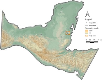
Lamanai is a Maya settlement located along the west bank of the New River Lagoon, the largest lake in Belize (Graham Reference Graham2004; Pendergast Reference Pendergast, Sabloff and Andrews1986) (see Figure 1 for a location of sites mentioned in this article). Over the last two decades, archaeologists have opportunistically surveyed between Lamanai and another large site, Ka’kabish (see McLellan Reference McLellan2020a). Many sites in the Maya area rely on systems of water reservoirs for rainfall collection, but the Lamanai area is comparatively rich in water, with wells, perennial springs, and the lagoon, which has been relatively stable over the last 10,000 years (Metcalfe et al. Reference Metcalfe, Breen, Murray, Purley, Fallick and McKenzie2009). The abundance of water in this area raises the question: Does the physical evidence in the periphery of Lamanai—specifically at Coco Chan, a site midway between the major centers—support the idea that the Maya relied on infield, urban forest gardens?
Location of Lamanai, Ka’kabish, Coco Chan, and other sites mentioned in this article (1. Caracol, 2. Lamanai, 3. Coco Chan, 4. Ka’kabish, 5. Chunchucmil, 6. Mayapan, 7. Blue Creek, 8. Coba, 9. Akab Muclil, 10. Tikal, 11. Palenque, 12. Sayil, 13. Dzibilchaltun, 14. Altun Ha). (Color online)

Figure 1 Long description
The map displays Maya sites and topography in a specific region. The legend indicates Maya sites marked by triangles and the Maya area shaded differently. Topography is shown with elevation ranging from 3.2 to 3,795 meters above sea level. A study area is highlighted with a rectangle. Labeled sites include Caracol, Lamanai, Coco Chan, Ka’kabish, Chunchucmil, Mayapan, Blue Creek, Coba, Akab Muclil, Tikal, Palenque, Sayil, Dzibilchaltun and Altun Ha. The map includes a scale bar indicating distances from 0 to 150 km.
By analyzing the settlement patterns in the periphery of Lamanai, which is aided by new data from light detection and ranging (lidar) and comparing the patterns to models of hydrology, we aim to assess the applicability of forest garden models to Maya settlement near the New River Lagoon, and more generally, in Northern Belize. Based on the density of settlement, the location of Coco Chan, its position surrounding a low-elevation, seasonally inundated swamp, and an analysis of hydrology, we argue that the Maya in the area used wetland management strategies (e.g., ditches, berms, and channels) to develop outfield agriculture, and that the limited space between residential units prevented the development of orchards and milpas within the settlement system (i.e., between plazuela groups). This conclusion is supported by (1) the location of Coco Chan; (2) the density, or urban spacing; of settlement at Coco Chan; (3) evidence of wetland management strategies; and (4) dietary evidence from Lamanai, which shows a reliance on maize. Extensive research in Northern Belize over the last two decades suggests that many sites in the region adapted to environmental conditions by constructing wetland agricultural systems. Many of these sites continued to be occupied throughout the Classic Maya collapse, which opens new avenues in the research of sustainability and resilience, especially during extreme weather events, such as drought.
Models of Maya Settlements and Their Subsistence Patterns
Low-Density Urbanism
Scholars in the Maya area have discussed for several decades the structural composition of Maya sites, their degree of urbanism, and how their cities compare to other settlement systems worldwide (see Smith et al. Reference Smith, Ortman, Lobo, Ebert, Thompson, Prufer, Stuardo and Rosenswig2021). Mayanists moved from models known as “vacant ceremonial centers” (nonurban spaces occupied by sparse elite populations [see Morley Reference Morley1946]) to regal-ritual centers (residences of rulers and clients with urban architecture [see Chase et al. Reference Chase, Chase and Haviland1990; Sanders and Webster Reference Sanders and Webster1988]), and, more recently, to low-density agrarian-based urban cities (Fletcher Reference Fletcher2009). Continued work by archaeologists in the Maya area, especially at Tikal and Caracol, has influenced our current perspective, which emphasizes a model of dispersed patterns of settlement—a pattern archaeologists argue was driven by “ecological rules” (Scarborough et al. Reference Scarborough, Chase and Chase2012:21). The Maya area comprises a myriad of environmental settings and a variety of settlement patterns, which suggests that the Maya adapted to specific environmental regions in different ways (e.g., Mathews and Morrison [Reference Mathews and Morrison2006] for Northern Yucatán adaptations).
The compact cities in the northern lowlands, such as Coba, Chunchucmil, and Mayapan, indicate that Maya settlement patterns are complex and show temporal as well as spatial variability (Folan et al. Reference Folan, Hernandez, Kintz, Fletcher, Heredia, Hau and Canche2009; Garduno Reference Garduno Argueta1979; Hutson Reference Hutson2016; Hutson et al. Reference Hutson, Hixon, Magnoni, Mazeau and Dahlin2008). Archaeologists suggest that the walled residential groups at these sites might represent a different urban tradition than settlements in the southern lowlands (Chase and Chase Reference Chase and Chase2016). Chase and Chase (Reference Chase and Chase2016:6) argue that the spacing, or density, of residential groups may have affected Maya subsistence patterns, with sites in the northern lowlands relying less on “inter-household agriculture” (see McLellan [Reference McLellan2020a:251–252] for a discussion on Maya urban traditions). Mayanists argue that the spacing of urban structures is key to understanding both the subsistence patterns of the city, and the sustainability and resilience of its inhabitants (Chase and Chase Reference Chase and Chase2016; Graham and Isendahl Reference Graham, Isendahl, Isendahl, Ekblom and Lindholm2018; Isendahl and Smith Reference Isendahl and Smith2013).
Forest Gardens
Changes in the scholarly conception of urbanism in the Maya area, coupled with new studies in soil chemistry, allowed archaeologists to hypothesize that open plazas at Maya sites may have been used for vegetable gardens, changing Maya stone cities to garden cities (see Graham Reference Graham, Bacus and Lucero1999; Isendahl Reference Isendahl2012; Sabloff Reference Sabloff1996). The garden city model both supports and explains the concept of low-density urbanism (i.e., the settlements are low density because they need space between residential units for a mix of agroforestry and traditional milpa intercropping systems; see Nigh and Diemont [Reference Nigh and Diemont2013:e45] for an explanation of the Maya milpa, or “shifting cultivation” that transitions between open-field agriculture and woodland vegetation). For example, at Caracol, Chase and Chase (Reference Chase and Chase2016:6) suggest that there was a “building code,” with residential groups spaced generally 100–150 m apart. This building code is important to understanding the degree of infield agriculture as low-density agrarian-based urbanism requires a large amount of space between residential groups. That said, there is a long-standing debate in Maya archaeology about the nature and distribution of Maya subsistence patterns, with some scholars insisting that infield (i.e., within the urban system) agriculture/agroforestry dominated the landscape, while others argue that outfield (i.e., outside the urban system) agriculture/agroforestry was more common in the past (see Fedick et al. [Reference Fedick, Morell-Hart and Dussol2024] for a summary of agricultural adaptations and Fisher [Reference Fisher2014] for information on infield vs. outfield agriculture). The definition and conceptualization of cultivation systems and settlement patterns in this article are directly influenced by models of forest garden settlements presented by Ford and Clarke (Reference Ford, Clarke, Isendahl and Stump2015; see Figure 9.3.1 for a reconstruction of the milpa cycle landscape).
The debate between infield and outfield sustenance strategies is tied to the primary question: Did the Maya deforest/degrade their environment, or did they manage their natural resources? Some archaeologists argue that traditional milpa systems caused soil erosion and deforestation, eroding the productivity of the landscape, and ultimately, collapsing the settlement system (Beach et al. Reference Beach, Luzzadder-Beach, Cook, Dunning, Kennett, Krause, Terry, Trein and Valdez2015; Kennett and Beach Reference Kennett and Beach2013; Turner and Sabloff Reference Turner and Sabloff2012). Others argue that the management of garden systems replenished soils and created biodiverse environments that provided a range of agroforestry agricultural resources (see Ford Reference Ford, Hutson and Arden2020; Ford and Clarke Reference Ford, Clarke, Isendahl and Stump2015). It is likely that specific subsistence patterns were more successful in certain regions, with each independent Maya city providing an example of a range of human-environment adaptations. The settlement in the periphery of Lamanai represents another example of the diversity and complexity of ancient Maya settlement pattern and cultivation systems and adds to a growing understanding of Maya adaptations and sustenance strategies in tropical environments.
Lamanai, Ka’kabish, and Coco Chan
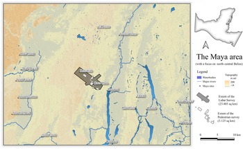
Evidence of forest clearing and maize cultivation from pollen samples and cores collected at the north end of Lamanai—a Maya site located in north-central Belize (Figure 2)—indicate that an agricultural village existed in this area around 1500 BC (Lentz et al. Reference Lentz, Graham, Vinaja, Slotten and Jain2016; Rushton et al. Reference Rushton, Metcalfe and Whitney2013, Reference Rushton, Whitney and Metcalfe2020). By the Middle Formative period (ca. 600 BC) Lamanai had developed into a larger community with civic-ceremonial structures and burials of early elites (Powis Reference Powis2002). Occupation at the site, which began in the north spread southward along the shores of the lagoon by this time (Powis Reference Powis, Lohse and Valdez2004:52).
The Ka’kabish-Lamanai corridor showing the lidar survey area, the location of pedestrian surveys, major rivers, bodies of water, topography (SRTM derived), and other Maya sites. (Color online)

Figure 2 Long description
The map of the Maya area in north-central Belize highlights the extent of lidar and pedestrian surveys. The legend indicates major rivers, water bodies and topography. The lidar survey area covers 23.54 sq km and the pedestrian survey area covers 12.52 sq km. Key locations such as Ka’kabish and Lamanai are marked. The map includes a scale bar for distance reference.
The founding of Ka’kabish—a Maya site on a limestone up-lift approximately 10 km inland northwest of Lamanai—appears to have occurred at the same time as the expansion of occupation at Lamanai (Haines et al. Reference Haines, Sagebiel and McLellan2020; Pendergast Reference Pendergast1981; Powis Reference Powis2002). At Ka’kabish a secondary burial was interred in a grave dug into the bedrock, accompanied by a wealth of marine shell beads and 17 jade objects including a rare spoon pendant (Haines Reference Haines2024; Locket-Harris Reference Lockett-Harris2016). Additional jade and marine objects were found to the south of the burial and likely formed a type of ritual earth-offering (Lockett-Harris Reference Lockett-Harris2016). The wealth of objects along with the Swasey ceramics, a type not found at Lamanai (Sagebiel et al. Reference Sagebiel, Kosakowsky, Pring and Walker2023:107), indicate that Ka’kabish and Lamanai were most likely autonomous entities at this time operating in different cultural spheres.
Both sites appear to have thrived through the Late Formative period, with the High Temple at Lamanai and the first iteration of temples D-4 and D-9 at Ka’kabish being constructed at this time (Haines et al. Reference Haines, Sagebiel and McLellan2020; Pendergast Reference Pendergast1981). It is during the Late Formative period (ca. 300 BC–AD 250) that we also see the beginning of construction at Coco Chan (McLellan Reference McLellan, Sagebiel and Haines2020b). During this period ceramic types at Maya centers became homogenized, with centers participating in the Chicanel ceramic sphere. Many of the common ceramic types for this period (e.g., Sierra Red, Consejo Red, Flor Cream) are found at all three sites (Haines et al. Reference Haines, Sagebiel, Morton and Peuramaki-Brown2019; Powis Reference Powis, Lohse and Valdez2004; Sagebiel Reference Sagebiel2020; Sagebiel and Haines Reference Sagebiel and Haines2015).
Evidence for the Early Classic period (ca. 250–450 BC) at Ka’kabish and Lamanai is found in the architectural developments at both sites and the continued wealth of objects recovered at Lamanai. At Lamanai we see the construction of N9-56; this building, which dates to the late fifth or early sixth centuries (Pendergast Reference Pendergast1981), was decorated with large stucco masks that likely represent rulers (Mayer Reference Mayer1988). These masks and the associated building were deliberately preserved during the subsequent building phase. The preservation of the structure was an “exception to the norm at Lamanai” as construction episodes often “involved extensive, and seemingly random, demolition of structures prior to the raising of new units” (Pendergast Reference Pendergast1981:37). At Ka’kabish, we see the creation of large temples complete with tombs on an acropolis dated to this period (Haines et al. Reference Haines, Sagebiel and Belanger2017, Reference Haines, Sagebiel, Morton and Peuramaki-Brown2019) and the creation of a possible palace, Structure D-14 (Haines et al. Reference Haines, Sagebiel and McLellan2020). Mortuary architectural styles show clear links between the acropolis graves and Central Petén (Haines and Helmke Reference Haines and Helmke2016), while ceramics recovered show ties to Tikal. A grave discovered in Structure D-5 uses a mortuary architectural style unique from those in the acropolis. Constructed using a wicker hoop and plaster coated textiles to create a “cocoon-like chamber,” the only other examples of this mortuary architecture are from Lamanai (Haines Reference Haines2008; Pendergast Reference Pendergast1981:37).
The end of the Early Classic period was marked by dramatic changes across the political landscape of the southern lowland Maya (Martin and Grube Reference Martin and Grube2008), and, while this upheaval was most notable in Central Petén, it also affected north-central Belize. At Ka’kabish the palace was built over, with the rooms carefully preserved suggesting that the construction, while done by inhabitants at the site, was perhaps not done by choice (Haines and Sagebiel Reference Haines, Sagebiel, Morton and Peuramaki-Brown2019; Haines et al. Reference Haines, Sagebiel and McLellan2020). The succeeding early facet of the Late Classic (Tepeu I period) saw a marked hiatus in building activities in the epicenter at Ka’kabish, although populations in the surrounding settlement zone seemed largely unchanged (McLellan Reference McLellan2012, Reference McLellan2020a). Similarly, “Lamanai was certainly not abandoned” but the exact effect of collapse of Tikal here is uncertain (Graham Reference Graham2004:231). Unlike Ka’kabish, Lamanai did not suffer from a building hiatus but rather experienced a shift in construction methods, choosing to focus on remodeling facades of public buildings rather than the extensive demolishing and reconstruction practiced earlier (Pendergast Reference Pendergast, Chase and Chase1992:73).
Around the end of the eighth or beginning of the ninth century in the Terminal Classic period construction resumes at Ka’kabish (Haines et al. Reference Haines, Sagebiel and McLellan2020) and increases at Lamanai (Graham Reference Graham2004). Building activity at Ka’kabish and Lamanai continues unabated into the Early Postclassic period (ca. AD 900–1200), with activity at Lamanai through the Late Postclassic and into the contact period (Graham Reference Graham, Rice and Sharer1987, Reference Graham2004, Reference Graham2011; McLellan Reference McLellan2020a; McLellan and Haines Reference McLellan and Haines2013). The Postclassic period is also when activity and population increased at Coco Chan (Haines et al. Reference Haines, McLellan and Sagebiel2023; Moore Reference Moore and Haines2024; McLellan Reference McLellan2020a, Reference McLellan, Sagebiel and Haines2020b; McLellan and Haines Reference McLellan and Haines2023; McLellan and Tremain Reference McLellan, Tremain and Haines2024). Whether the three sites remained a unified polity in the Postclassic or fractured into two, or three, separate political entities is unclear; however, Maya populations continued to occupy the landscape throughout the succeeding colonial periods (Bolland Reference Bolland2004:109; Graham et al. Reference Graham, Pendergast and Jones1989, Reference Graham2011; Jones Reference Jones1989:135–152; Thomson Reference Thomson2004:91).
Methods
In 2022 the Ka’kabish Archaeological Research Project (KARP) participated in the National Center for Airborne Laser Mapping’s (NCALM) Belize Lidar Campaign, which brought many projects together thereby creating a unified standard for the datasets from the various regions. More accurately called ALS (aerial laser scanning), lidar (light detection and tanging) allows large areas to be surveyed in a fraction of the time required by pedestrian surveys and is useful to both locate new sites (Doneus et al. Reference Doneus, Briese, Fera and Janner2008; Inomata et al. Reference Inomata, Pinzón, Ranchos, Haraguchi, Nasu, Fernandez-Diaz, Aoyama and Yonenobu2017; Ornes Reference Ornes2014) as well as verify and extend previously surveyed areas (Chase et al. Reference Chase, Chase and Weishampel2010, Reference Chase, Chase, Weishampel, Comer and Harrower2013, Reference Chase, Chase, Awe, Weishampel, Iannone, Moyes and Yaeger2014a; Ford Reference Ford2016; Hare et al. Reference Hare, Masson and Russell2014; Inomata et al. Reference Inomata, Triadan, Lopez, Fernandez-Diaz, Omori, Belén Méndez Bauer and García Hernández2020). Although it was first used in the 1930s, it was not until recent technological advances enabled greater penetration of forest canopy that the process was used in dense tropical rainforests (Chase et al. Reference Chase, Chase and Weishampel2010, Reference Chase, Chase, Fisher, Leisz and Weishampel2012, Reference Chase, Chase, Awe, Weishampel, Iannone, Moyes, Yaeger and Brown2014b; Evans et al. Reference Evans, Fletcher, Pottier, Chevance, Soutif, Tan and Sokrithy2013; Hutson Reference Hutson2015; Ornes Reference Ornes2014). In the Maya area, lidar was initially used to identify new sites in mature forests (Chase et al. Reference Chase, Chase and Weishampel2010, Reference Chase, Chase, Weishampel, Drake, Shrestha, Slatton, Awe and Carter2011, Reference Chase, Chase, Fisher, Leisz and Weishampel2012), but more recently it has been employed in places with a history of modern development, such as the Belize River Valley, with established agricultural fields and pastures, mature secondary vegetation, and modern urban settlements (Cap et al. Reference Cap, Yaeger and Brown2018; Inomata et al. Reference Inomata, Triadan, Lopez, Fernandez-Diaz, Omori, Belén Méndez Bauer and García Hernández2020; Prufer et al. Reference Prufer, Thompson and Kennett2015; Walden et al. Reference Walden, Hoggarth, Ebert, Fedick, Biggie, Meyer and Shaw-Müller2023; Yaeger et al. Reference Yaeger, Brown and Cap2016).
NCALM is a leader in the field of airborne, plane-based, lidar and, in conjunction with the Caracol Project, conducted the first lidar surveys in Belize (Chase et al. Reference Chase, Chase and Weishampel2010, Reference Chase, Chase, Fisher, Leisz and Weishampel2012). Over the past decade NCALM has collaborated with numerous archaeological projects across the Maya world (Canuto et al. Reference Canuto, Estrada-Belli, Garrison, Houston, Acuña, Kováč and Marken2018; Chase et al. Reference Chase, Chase and Weishampel2010, Reference Chase, Chase, Awe, Weishampel, Iannone, Moyes and Yaeger2014a; Inomata et al. Reference Inomata, Pinzón, Ranchos, Haraguchi, Nasu, Fernandez-Diaz, Aoyama and Yonenobu2017, Reference Inomata, Triadan, Lopez, Fernandez-Diaz, Omori, Belén Méndez Bauer and García Hernández2020, Reference Inomata, Fernandez-Diaz, Triadan, Mollinedo, Pinzón, Hernández and Flores2021; Stanton Reference Stanton, Ardren, Barth, Fernandez-Diaz, Rohrer, Meyer, Miller, Magnoni and Pérez2020; see also Canuto Reference Canuto2022). While the area around Lamanai to the east and the Birds of Paradise Wetlands to the west have both been previously surveyed, the 2022 campaign marked the first time that the terrain forming KARP’s research base was subject to lidar survey.
In May 2022 NCALM established a ground station on top of the water pumping station in Indian Church Village. Despite the relative remote location of the village, the water pumping station was able to provide a secure location for the equipment and constant electricity by virtue of solar panels to the GNSS receiver. Additionally, as the station was located next to the village soccer pitch it had a clear view of the sky and therefore was able to establish excellent satellite links.
Airborne data collection was conducted using a Teledyne Optech Titan MW (multiwavelength) airborne multispectral lidar scanner operating at 150 Khz mounted to a small plane (see Fernandez-Diaz et al. Reference Fernandez-Diaz, Carter, Glennie, Shrestha, Pan, Ekhtari, Singhania, Hauser and Sartori2016). The plane, which had a flying altitude of 650 m, allowed for swath widths of 750 m with a 50% overlap between the adjacent swaths. The system, which used 15 pulses/m2, provided a vertical accuracy of 5–10 cm (1σ) and a horizontal accuracy of 15–20 cm (1σ). Initial post processing of the data was done by NCALM with additional work by McLellan and Bacon at Trent University.
The point cloud of individual points reflected from the surface was used to create a bare earth digital elevation model (DEM) of the survey area. The raw lidar data (.las file) was processed using an open-source 3D point cloud and mesh processing software called CloudCompare. The DEM (processed at 50 cm) was then imported into QGIS, an open-source geographic information system (GIS). For the hydrological analysis (terrain analysis), the tool SAGA (System for Automated Geoscientific Analyses) was used to create a catchment area, also known as flow accumulation. The analysis, which was used to assess the volumetric flow of water from the watershed over time, was then compared to the settlement pattern in the periphery of Lamanai at Coco Chan.
We used common pedestrian survey techniques to document the settlement patterns in opportunistically selected fields (see Figure 2 for their locations) and to ground truth archaeological features identified in the lidar data (e.g., the channels in the bajo). When we encountered the limestone debris remains of residential foundations, we mapped the size of the structures and collected diagnostic ceramic artifacts from the surface. Ceramic specialists, including Kerry Sagebiel and Jim Aimers, catalogued the artifacts and used type-variety analysis to determine the chronology of individual structures. These analyses show that most of the structures at Coco Chan are dated to the Early Postclassic period (i.e., to the tenth and eleventh centuries).
Settlement Patterns, Lidar, Drainage, and Hydrology
Archaeologists at Lamanai, Ka’kabish, and Coco Chan have identified approximately 1,500 structures between the New River Lagoon and Ka’kabish (approx. 10 km). There are several areas of noticeable drop-off in settlement density, mostly west and northwest of Coco Chan. This drop-off in settlement density may represent a polity boundary between Coco Chan and its larger neighbor, Ka’kabish. The settlement southeast of Coco Chan is only 2.5 km northwest of the largest site in the region, Lamanai (see McLellan [Reference McLellan2020a:31–42] for the settlement pattern of the site). It is likely that large portions of the corridor between Coco Chan and Lamanai were inhabited in the past. Informal surveys (e.g., visual inspection of satellite data and drone surveillance) show the scattered limestone debris of residential platforms in several cleared fields between the southeastern settlement and Lamanai. Also, the fields south of Coco Chan show evidence of settlement, which may connect Coco Chan with another small body of water 3 km from its civic-ceremonial center.
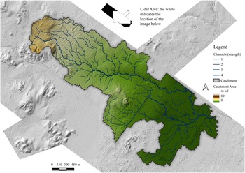
Coco Chan is surrounding one of the lowest areas in the landscape, next to a seasonally inundated swamp, or bajo, that is between 0 and 5 m asl (see Figure 3 for an analysis of the hydrology of the lidar survey zone). The settlement at the site encircles the southern portion of the bajo, occupying an elevation between 5 and 15 m asl. There are higher elevation areas immediately west and northwest of Coco Chan, but they are mostly unoccupied (15–30 m asl, based on a topographic analysis of the lidar DEM). Pedestrian surveys have not identified any evidence of terracing or water reservoirs between Lamanai and Coco Chan (unlike Ka’kabish, which has a potential large water reservoir system in the civic-ceremonial center and several small catchments in the periphery). The modern system of roads and agricultural intensification in the lidar survey zone may have impacted the distribution of waterways, but many areas are still undeveloped. There are also several wells found throughout the survey area, including two at Coco Chan, but little work has been done on identifying archaeological materials associated with them.
Catchment area with channels overlaid on a lidar hillshade showing the drainage of the Coco Chan bajo. (Color online)

Figure 3 Long description
The map displays a catchment area with channels overlaid on a lidar hillshade, illustrating drainage patterns. The legend indicates channel strength with values from 1 to 5, represented by varying line thicknesses. The catchment area is shaded in a gradient from 0 to 100, with darker shades indicating higher values. The map includes a scale bar ranging from 150 to 600 meters. An inset shows the lidar area location. The channels are distributed throughout the catchment, with denser networks in the central and southern regions and sparser networks in the northern areas.
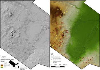
Flow accumulation analysis, delineation of the drainage basin, and the mapping of water channels show that Coco Chan is surrounding the southern portion of a major watershed in the region (Figure 3). The strongest channels are found north and east of the civic-ceremonial center, which places it outside of areas with potential flooding. The site surrounds the southern edge of the bajo (see Figure 4 for the spatial relationship between Coco Chan and the bajo), with some structures found less than 5 m asl, which is uncommon at Maya sites as they are usually found in hills or elevated locations (e.g., the hills directly west and northwest of Coco Chan are generally inhabited by the Maya; see Figure 3).
(Left) Lidar hillshade of Coco Chan; (right) location of structures (structures identified by pedestrian survey = red, structures identified by lidar = yellow). (Color online)

Figure 4 Long description
The image consists of two maps of Coco Chan. The left map is a digital elevation model using lidar, showing terrain features with elevation indicated by shading. The right map displays the location of Maya structures. Structures identified by pedestrian survey are marked in red, while those identified by lidar are marked in yellow. The map includes a scale bar indicating distances of 200, 400 and 600 meters. The elevation model highlights variations in terrain, while the structure map shows the distribution of structures across the area.
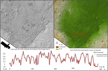
Analysis of the lidar data shows that the Maya at Coco Chan invested labor into wetland management strategies, including the use of channels adjacent to the bajo, and possibly low earthen/stone walls within the settlement (see Figure 5 for the relationship between the system of channels and the settlement). The channels are oriented north-to-south and east-to-west on the southern portion of the bajo, covering approximately 14 ha, and range from 10 to 100 m long, 1 to 2 m wide, and up to 1 m deep (see the profile line that bisects the system of channels at the bottom of Figure 5 for the length/width/depth of a 400 m portion of the fields). It is likely that the channels extend northeast of the southern portions of the bajo, but agricultural development has impacted the integrity of the archaeological record (i.e., ploughing has erased the channels). Another system of channels is visible in satellite imagery at a small waterbody surrounded by plazuela groups 3 km south of Coco Chan. The low earthen/stone walls southeast of Coco Chan need to be formally assessed, but they may spatially define household units and the extent of accompanying home gardens.
Hillshade, digital elevation model, and profile of wetland management strategies.

Figure 5 Long description
The image A showing a shaded relief terrain map with a black arrow symbol and the text “Lidar Arrow the white indicates the location of the images above”. The image B showing a shaded relief terrain map with a red straight line marking a transect. Text near the bottom reads “Profile line bisecting the system of channels”. A scale bar is labeled “0 12”. A line graph shows a single red line for the profile along the transect. The x-axis shows tick labels 0, 100, 200, 300, 400 and the unit “m”. The y-axis shows tick labels 1.8, 1.9, 2.1, 2.2, 2.4, 2.6, 2.8. The red line starts near 2.0 at x equals 0, rises and falls repeatedly, reaches multiple local peaks near 2.7 to 2.8, reaches multiple local lows near 1.9 to 2.0 and ends near 2.2 at x equals 400.
Discussion
Several lines of evidence suggest that the Maya in the Ka’kabish-Lamanai area used wetland management strategies to support Maya populations, including (1) the location of the site next to a seasonally inundated swamp; (2) the density, or urban spacing, of settlement, which reduced the available land for forest gardens; (3) evidence of channels adjacent to settlement; and (4) evidence from Lamanai that shows a diet dependent on maize, rather than varied field and forest crops. Coco Chan is low in the landscape (between 0 and 15 m asl), even though there are several well-drained hills and ridgetops nearby (>1.5 km west of the site; see Figure 3). Flat upland hills are traditionally viewed by archaeologists as suitable building sites for the Maya (with predictive models of Maya settlement usually based on elevation as a key variable) (Vaughn and Crawford Reference Vaughn and Crawford2009; see Bullard Reference Bullard1960:365). Evidence from archaeological studies in the interior of the Maya lowlands support the claim that the Maya only marginally inhabited low-lying elevations near bajos, such as in the Corona-Achiotal region, in which archaeologists found only 5.5% of structures located at the edges of bajos (Canuto and Thomas Reference Canuto and Auld-Thomas2021:11; Ford Reference Ford1986). In the Lamanai-Ka’kabish corridor, the Maya built structures along the low ridges adjacent to the bajo—rather than in the nearby hills—and invested labor into wetland management strategies, such as the channelization of the margins of bajos, instead of developing systems of terraces and water reservoirs in upland areas.
Forest gardens are dependent on a high degree of urban spacing, which creates space for infield agriculture and agroforestry. As mentioned, at Caracol archaeologists found that residential groups were, on average, between 100 and 150 m apart (Chase and Chase Reference Chase and Chase2016:6). Models of forest garden subsistence patterns at El Pilar show that residential groups require roughly 2,500 m2 for trees, orchards, and maize fields (see Ford et al. Reference Ford, Turner, Mai and Hufnagel2022:6). Residential groups at Coco Chan are too close (i.e., between 15 and 50 m) to resemble these models, which have trees/orchards/maize fields within the settlement system (i.e., among the structures). The settlement between Ka’kabish and Coco Chan has a high degree of urban density, especially when compared to other sites in the Maya area (i.e., a calculated value of 156 residential groups per km2 [see Koch Reference Koch2023:109]). This suggests that the Maya kept small house gardens, but that the fields and orchards were on the outskirts of the settlement. Residential groups in the settlement southeast of Coco Chan are between 15 and 30 m apart (which is determined by measuring average distances between plazuela groups) and these spaces form an essential part of the watershed, providing drainage for the settlement system (see the southeastern portion of Figure 4). Evidence from dietary analysis of individuals at Lamanai supports this conclusion, with maize varying by time, but sometimes contributing up to 70% of their diet (White and Schwarcz Reference White and Schwarcz1989).
Evidence of wetland agriculture and wetland agroecosystems are found at many sites in Northern Belize (Bloom et al. Reference Bloom, Pohl, Stein and Pohl1985; Guderjan and Krause Reference Guderjan and Krause2011; Krause, Beach, Luzzadder-Beach, Guderjan, et al. Reference Krause, Beach, Luzzadder-Beach, Guderjan, Valdez, Eshleman, Doyle and Bozarth2019, Reference Krause, Beach, Luzzadder-Beach, Cook, Bozarth, Valdez and Guderjan2021; Kunen Reference Kunen2001; Pope and Dahlin Reference Pope and Dahlin1989; Pohl Reference Pohl1990; Turner and Harrison Reference Turner and Harrison1981), and north of Lamanai (Pendergast Reference Pendergast1981). Raised field systems in the Yucatán Peninsula share morphological similarities with the channels at Coco Chan (see Dunning et al. [Reference Dunning, Ruhl, Carr, Beach, Brown and Luzzadder-Beach2020:Figure 6c, Figure 7] for a comparable field system and Šprajc et al. [Reference Šprajc, Dunning, Štajdohar, Hernández Gómez, López, Marsetič and Ball2021:Figure 3]). In Belize, at Blue Creek, a site 25 km northeast of Lamanai, archaeologists argue that a system of raised fields were large enough to export agricultural resources to the greater region (Guderjan and Hanratty Reference Guderjan, Hanratty, Iannone, Houk and Schwake2016:227). Evidence from Maya settlements in low elevations suggests that wetland agriculture was an important adaptation for sustaining populations in Northern Belize. This is important because studies on Maya settlement abandonment and collapse in the seventh to tenth centuries show that towns and cities in Northern Belize were flourishing throughout these periods (see Walker [Reference Walker2016:14–20] for a list of Maya sites that were occupied in Northern Belize with Late Classic, Terminal Classic, and Early Postclassic, ca. AD 600–1200). Archaeologists argue that one of the few sites that persisted into the thirteenth century in Northwest Belize, Akab Muclil, endured because it was next to a perennial swamp that was used for wetland agriculture (Krause, Beach, Luzzadder-Beach, Cook, et al. Reference Krause, Beach, Luzzadder-Beach, Cook, Islebe, Palacios-Fest, Eshleman, Doyle and Guderjan2019:156).
Archaeologists are starting to uncover the variety and spatial patterns in the distribution of human-environment adaptations in the Yucatán Peninsula (see Fedick et al. Reference Fedick, Morell-Hart and Dussol2024; Leonard et al. Reference Leonard, Sedov, Solleiro-Rebolledo, Fedick and Diaz2019; Morell-Hart et al. Reference Morell-Hart, Dussol and Fedick2023). Adaptations in the Maya area are restricted to the location and environmental conditions of the site (i.e., elevation, vegetation, bedrock geology, and water). Topographic conditions affected the range of adaptations available to Maya settlements (i.e., sites in high elevations used terraces and water reservoirs to capture rainwater and retain soil, and sites in low elevations used channels, ditches, low-lying stone and earthen walls, and raised fields to direct water and provide soil stability). Many scholarly models of the Maya are derived from regions that are dominated by karstic limestone, which is porous and rain-driven and creates conditions for terraces and water reservoirs (see Fletcher [Reference Fletcher2009]; Scarborough et al. [Reference Scarborough, Chase and Chase2012], for Tikal and Caracol, respectively). Low-elevation, flood-prone areas in the Maya area are considered less in these models (see Beach et al. [Reference Beach, Luzzadder-Beach, Krause, Guderjan, Valdez, Fernandez-Diaz, Eshleman and Doyle2019] for an exception), even though these environments are vital to other settlement systems in human history (e.g., Jotheri et al. Reference Jotheri, Feadha, Al-Janabi and Alabdan2022). It is likely that settlements with wetland agriculture are vital to understanding the reaction of the Maya to major abandonment/depopulation events at the end of the first millennia, especially considering mounting evidence of drought throughout the Maya area (Akers et al. Reference Akers, Brook, Railsback, Liang, Iannone, Webster, Reeder, Cheng and Edwards2016, Reference Akers, Brook, Railsback, Cherkinksy, Liang, Ebert, Hoggarth, Awe, Cheng and Edwards2019; Kennett et al. Reference Kennett, Breitenbach, Aquino, Asmerom, Awe, Baldini and Bartlein2012; Webster et al. Reference Webster, Brook, Railsback, Cheng, Lawrence Edwards, Alexander and Reeder2008).
Conclusion
It is common for archaeologists to argue that Maya agriculture and agroforestry systems relied on rainfall, especially because of regional analyses of large upland sites such as Caracol and Tikal. New research in Northern Belize suggests that the Maya used wetland management strategies to improve natural drainage systems in low elevations, creating formal and informal systems of irrigation for wetland agriculture. Many examples of field systems in the Maya area show the same geomorphology/form as the fields at Coco Chan and have been validated with evidence from soil/pollen studies. Future studies in the area should focus on soil and pollen analysis to help support the evidence presented in this article, but they are not vital to the interpretation of the channels at Coco Chan. The fields between Lamanai and Ka’kabish continue to be threatened by ongoing development (e.g., agricultural and residential), which has already damaged evidence of settlement and human-environmental adaptations. Excavation of the channels at Coco Chan will allow archaeologists to investigate construction sequences and look for potential periods of expansion. Excavation is vital in addressing the research question: Did the Maya build, or expand, wetland management strategies in the Lamanai-Ka’kabish area as a reaction to major drying periods/drought? For Maya studies, archaeologists are encouraged to create a centralized database of sites in the Yucatán Peninsula with a comprehensive list of human-environment adaptations (based on presence or absence) to look for regional patterns in the use of specific adaptations (e.g., terraces, water reservoirs, wetland field systems). Uncovering the spatial distribution of adaptations may help to explain the varied successes and failures of the Maya urban experiment in the past.
Acknowledgments
We would like to acknowledge the assistance of the National Center for Airborne Laser Mapping (NCALM), which provided technological and material support for the project.
Funding Statement
This research received no specific grant funding from any funding agency, commercial, or not-for-profit sectors.
Data Availability Statement
Lidar data for the Lamanai-Ka’kabish corridor is owned by the Ka’kabish Archaeological Research Project and may be available upon request.
Competing Interests
The authors declare none.

 Open access

