

Introduction
The study of European urban deposits (Nicosia et al. Reference Nicosia, Devos, Macphail, Nicosia and Stoops2017), including Late Roman to early medieval dark earth, commenced with Rescue, an early organisation carrying out mitigation archaeology, recognising that these apparently ‘unstratified’ deposits should not simply be machined-away, but could reveal several centuries of urban history (Biddle et al. Reference Biddle, Hudson and Heighway1973; Carver Reference Carver, Schofield and Leech1987). Post-Roman dark earth sensu stricto did not record the complete abandonment of urban areas across Europe in the fifth century AD, after the decline of the Western Roman Empire, but more often reflected a change in use of urban space according to local circumstances (Galinié Reference Galinié2000; Macphail et al. Reference Macphail, Galinié and Verhaeghe2003).
In England, Late Roman urban occupation deposits have been investigated from Canterbury, Leicester, Pevensey (Anderitum), Winchester, Worcester and, especially, London. While dark earth from the medieval castle ditch at Exeter has previously been analysed (Macphail & Courty Reference Macphail, Courty, Edgren and Jungner1985; Macphail Reference Macphail, Lorans and Rodier2014), in general, the Roman city of Exeter has received limited geoarchaeological analyses of its urban deposits. Excavations ahead of changes to the East Cloister Walk and Chapter House of Exeter Cathedral in 2020 provided new opportunities to investigate the post-Roman and medieval levels (Figures 1 & 2).
Location map of the East Cloister Walk and Chapter House, Exeter Cathedral. The Roman sea port of Topsham is located 7km downstream (figure by J. Allan).

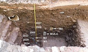
a) Sondage revealing a Roman mortar floor in the East Cloister Walk, Exeter Cathedral; sampling tins M1 (2029/2034), M2 (2033/2029), M3 (M3A, M3B and M3C; 2008) and M4 (2007/2008) are visible in the section; b) Chapter House profile: sampling through Roman, dark earth (thin sections M4A-B) and medieval (Med) levels. Sample M1 is in a possible grave cut (Gr?) (figure by R. Macphail).

Materials and methods
The two 1.50m-deep Exeter Cathedral profiles were situated approximately 12m apart. They were studied using 12 thin sections (Figure 2) and 22 bulk environmental samples. The methods for thin sections involved soil micromorphology, including SEM/EDS (Energy Dispersive X-ray Spectrometry), whilst bulk samples were analysed using organic matter estimates (LOI), particle size, carbonate (CO3), magnetic susceptibility (MS) and ICP-MS elemental analyses, including phosphorus (P). Standard methods were used, following Goldberg et al. (Reference Goldberg, Macphail, Carey and Zhuang2022: Chapter 17).
Results and discussion
At both locations, the latest sampled Roman levels have similar characteristics, such as lime mortars tempered with basalt, and ground-raising levels composed of red-coloured, burnt, earth-based building materials. The latter resulted in enhanced magnetic susceptibility and high CO3 and calcium (Ca) values. The post-Roman dark earth in the cloister profile yielded food and possible latrine waste, along with coprolites from probable dog scavenging. Small bone fragments also testify to the consumption of fish, reflecting the lifestyle of local populations, and access to the River Exe and the sea; the Roman port of Topsham is located 7km downstream (Figures 1 & 3a–d). Clearly, the area was not abandoned. At the Chapter House, fish bone also occurs (Figure 3e), but greater inputs of artisan activity are recorded in the form of fine iron fragments and iron slag (Figure 4a). Non-ferrous metal working (Figure 4b–d) was also demonstrated by ICP-MS data (Figure 5).
a) Cloisters profile: photomicrograph of M3C (dark earth 2008 lower); midden waste includes heated fish bone (FB) and amorphous coprolitic material (Cop); plane polarised light (PPL), frame height is approximately 4.62mm; b) as 3a, under oblique incident light (OIL); note fish bone appears to be calcined; c) as 3b, amorphous (phosphatic) coprolite (autofluorescent under blue light), with void pattern and colours suggesting that it is probably a dog coprolite (EDS = 8.29–32.8% calcium, 4.32–9.54% phosphorus); PPL, frame height is approximately 2.38mm; d) photomicrograph of M3A (dark earth 2008 upper); weathered, probable coprolitic fish bone (bone is only weakly autofluorescent under blue light; EDS = 25.6–34.2% calcium, 11.9–15.3% phosphorus; n = 5); PPL, frame width is ~4.62mm; e) Chapter House profile; photomicrograph of ECCH-4B (dark earth); dark earth includes fish bone; PPL, frame width is approximately 2.38mm (figure by R. Macphail).

a) Chapter House profile: photomicrograph of ECCH-4B (dark earth); artisan working—‘rusty’ iron-working fragment (EDS = max ~95% iron oxide (FeO)); oblique incident light (OIL); frame width is ~4.62mm; b) non-ferrous metal alloy fragment; plane polarised light, frame width is ~2.38 mm; c) as 4b, under OIL; d) as 4b; X-ray backscatter image of copper-(tin)-lead alloy; EDS = 1.10–18.8% copper, 1.13–2.76% tin, 10.3–50.6% lead (n = 4 areas) (figure by R. Macphail).

Chapter House profile. Industrial heavy metals and elements: nickel (Ni), copper (Cu), zinc (Zn), arsenic (As), tin (Sn) and lead (Pb) (mg/kg). Concentrations of these heavy metals suggest artisan working (e.g. tin and lead) in the dark earth, while increased lead and zinc, especially, characterise the garden and suspected inhumations soils (figure by C. Carey and R. Macphail).

At the Cloister site, the medieval deposits presumed to be linked to the building of the Cathedral from c. AD 1114 onwards, are dominated by stony constructional remains, with peaks in Ca (e.g. use of limestone) and lead (Pb) (lead windows and soldering?). Medieval soils at the Chapter House (AD 1227) differ greatly, being moderately homogeneous and much more humic and phosphate- (P) rich compared with the Cloisters location (Figure 6). Although this is consistent with historical records of the use of the area as the bishop's garden prior to the building of the Chapter House, it does not fully explain the anomalous dark staining of the soil down to the underlying dark earth. It can be suggested from studies elsewhere that the ground was used for inhumations and that decomposition has led to a ‘body stain’ effect (Faul & Smith Reference Faul and Smith1980; Usai et al. Reference Usai2014). The test-pit profile itself was located very near a stone-lined grave, believed to be that of Serlo, the first Dean of Exeter, who died in AD 1231. Thus, as found across Europe, urban deposits need to be analysed and interpreted on a case-by-case basis (Galinié Reference Galinié2000), even when profiles are only 12m apart.
Comparison of Cloisters (CL) and Chapter House (CH) profiles–LOI (organic matter) and phosphorus. Chapter House medieval soils show a particularly high organic matter and phosphorus content compared with the Cloisters profile (figure by C. Carey and R. Macphail).

Conclusions
The soil micromorphology and geochemical analysis of urban deposits below Exeter Cathedral, from closely juxtaposed locations, has shown that urban deposits record active populations that post-date the Roman city and who focused on different activities. Medieval layers contrast even more clearly, further demonstrating the need for case-by-case urban soil studies.
Acknowledgements
The authors would like to thank the Cathedral Church of Saint Peter in Exeter for supporting this research. The help of Tom Gregory (UCL), Simon Hughes (AC Archaeology), Pete Lyons (Brighton University), Chris Sampson (Exeter Cathedral Estates) and Marc Steinmetzer (Oakford Archaeology) is gratefully acknowledged.
Funding statement
The Cathedral Church of Saint Peter in Exeter funded this research.


 Open access