

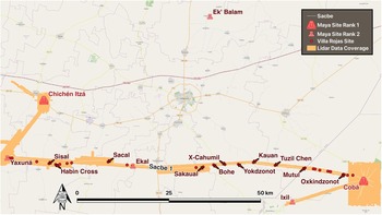
Using new lidar data from the ancient Maya urban centers of Coba and Yaxuna and the ancient road linking them, as well as excavation data, epigraphic inscriptions, and landscape reconnaissance, we argue that Sacbe 1 was integral to an effort by Coba elites to expand an urban experience into the center of the peninsula and thereby their political and cultural influence (Figure 1). Many distinctive spatial features of Maya cities affected the daily lives of their citizens and visitors in profound ways. Causeways, baffled entrances, ramps, and their human attendants were some of those features. The challenges of navigating crowds, sounds, smells, and a complex cityscape all materialized a particular identity as city dwellers, and sacbes were a distinctive connective feature of Classic Maya urban life. Based on new evidence, we argue that construction of Sacbe 1 was initiated by the leaders of Coba during a time of frenetic population growth to demonstrate their authority over the hinterlands through the expansion of urban life into the center of the peninsula (Magnoni et al. Reference Magnoni, Stanton, Barth, Diaz, Francisco Osorio León, Pérez Ruiz and Wheeler2016; Rohrer and Stanton Reference Rohrer, Stanton, Pennanen and Goosney2019; Stanton et al. Reference Stanton, Ardren, Barth, Fernandez-Diaz, Rohrer, Meyer and Miller2020; see also Loya González and Stanton Reference Loya González and Stanton2013, Reference Loya González, Stanton and Stanton2014).
Regional map with lidar coverage and sites mentioned in text. (Color online)

Figure 1 Long description
The map displays a regional view of the Yucatán Peninsula, highlighting Maya sites, sacbe routes and lidar data coverage. Key elements include: - Sacbe: Represented by a continuous line connecting various sites. - Maya Site Rank 1: Marked with a red triangle, indicating major sites such as Chichén Itzá and Coba. - Maya Site Rank 2: Marked with an orange triangle, indicating secondary sites. - Vía Robis Site: Marked with a yellow square. - Lidar Data Coverage: Shown as an orange shaded area, primarily around Coba. The map includes labeled locations such as Yaxuná, Chichén Itzá, Ek' Balam and Coba. The sacbe connects these sites, with notable stops at Sisal, Sacal, X-Cahumil and others. The scale bar indicates distances up to 50 km and a north arrow is present for orientation.
The massive investment of resources and specialized engineering skills represented in Sacbe 1 created a spatialized expression of elite ambition that not only enlarged the Maya’s territorial claims but also did so through the expansion of cityspace. Geography and history were inseparably linked in seventh-century Coba, likely through the efforts of an ambitious queen who controlled the vast resources of the Coba dynasty. In this article, we explore what is known about the engineering effort involved in the construction of a feature more massive than any acropolis group at Coba, as well as the natural and cultural resources it linked. We also call attention to the abundance of the sacbe’s small, unanticipated changes in direction, some of which are difficult to explain. By taking an urbanist perspective on sacbes and a spatial perspective on the urban experience of sacbes in ancient Maya society, we offer new insights about how Sacbe 1, as the preeminent example of materialized and spatialized state power, served to organize relations of power and dominance within the urban setting of Coba and its distant neighbor Yaxuna.
For nearly 100 years Mayanists have debated whether sacbes were primarily ritual or civic infrastructure—a dichotomy that we argue is misguided and rooted in Western epistemologies (Villa Rojas Reference Villa Rojas1934). Drawing a distinction between religious use and civic use is unproductive because both contribute to an urban experience: indeed, in ancient Maya society, as in much of New World Indigenous culture, one cannot easily separate religious experience from other forms of sociality, such as artistic or craft production, given the myriad ways each was embedded in the reproduction of collective identities. Likewise, given the ubiquity of “political theater” as a mechanism by which the state reproduced itself (Inomata Reference Inomata, Inomata and Coben2006), sacbes were likely multifunctional spaces in which all manner of state-sanctioned performance was enacted to reproduce social relations of power and urban identity. The relational work of creating, maintaining, and using sacbes was critical to generating the authority of those in power (Hutson and Welch Reference Hutson and Welch2021:312). We argue that the spatial dimension of sacbes as an expression of state power and resource deployment is underexplored, and we bring new data to an examination of the sociospatial dialectic at Coba and Yaxuna.
Roads, Infrastructure, and the State
There are hundreds of ancient raised roads throughout the Maya area, with more examples visible now because of the widespread use of lidar survey (Hansen et al. Reference Hansen, Morales-Aguilar, Thompson, Ensley, Hernandez, Schreiner, Suyuc-Ley and Martinez2022). Sacbes were first built in the Middle Formative period, and some were maintained well after Spanish contact, indicating they were a fundamental part of how the landscape was manipulated and understood throughout the entirety of prehispanic Maya history (Benavides Castillo Reference Benavides Castillo1981; Collins Reference Collins2022; Hansen et al. Reference Hansen, Morales-Aguilar, Thompson, Ensley, Hernandez, Schreiner, Suyuc-Ley and Martinez2022; Hutson and Welch Reference Hutson and Welch2021; Normark Reference Normark2010; Shaw Reference Shaw2008; Stanton Reference Stanton2005; Stanton and Freidel Reference Stanton and Freidel2005). Most sacbes were uniquely urban endeavors: shaped by the political and municipal forces within the largest polities of the Classic period, they were part of the creation and perpetuation of Maya culture that connected people and ideas through space.
Causeways undoubtedly served a variety of purposes. Scholars have suggested they were built to facilitate the basic transportation of people, the movement of goods by traders, the establishment or reinforcement of political alliances and boundaries, the solidification of kin relations, the performance of calendrical ceremonies, and resource management (Benavides Castillo Reference Benavides Castillo1981; Bolles and Folan Reference Bolles and Folan2001; Hutson et al. Reference Hutson, Magnoni and Stanton2012; Shaw Reference Shaw2008, Reference Hutson, Magnoni and Stanton2012). Other explanations emphasize the performative aspect of these broad paved avenues (Hutson and Welch Reference Hutson and Welch2021; Marengo Camacho Reference Camacho and Nelda2022; Ringle Reference Ringle, Grove and Joyce1999). Bishop Diego de Landa, in his sixteenth-century recollections of Yucatec Maya life, reported that the raised roads of the peninsula were used for ritual processions by noble families and ritual specialists conducting Yearbearer ceremonies (Restall et al. Reference Restall, Solari, Chuchiak and Ardren2023).
Causeway or road constructions have long been recognized as resource-intensive and economically expensive for the state, given their engineering, fabrication, and maintenance costs (Kurjack and Silvia Garza T. Reference Kurjack, Silvia Garza and Ashmore1981; Shaw Reference Shaw2008). More significantly they represent a materialization of relationships, which were often cooperative but also occasionally antagonistic, between the social entities they united. The site of Labna has a famous sacbe that typifies the integrative purposes of causeways by linking the main palace compound to the main civic complex containing the tallest pyramid, 160 m to the south (Ringle et al. Reference Ringle, Gallareta Negrón, Ciau, Seligson, Fernandez-Diaz and Ortegón Zapata2021). As an extension of both pyramid and palace, the sacbe is an ideal performative space for the movement of elites between these two restricted arenas. A procession here would have been in full view of anyone within the city center yet would be clearly delineated from mundane daily movements. At Dzibilchaltun, causeways provided stages on which those with privileged, specialized calendrical and astronomical training could march between spaces of heightened spiritual power, thus performing their access to restricted knowledge as they moved through the city within a restricted space. Shaw (Reference Shaw, Alcock, Bodel and Talbert2012:139) pointed out that the forms and destinations of some sacbes are quite distinct from footpaths, suggesting that raised causeways were not designed to be used for everyday traffic, even if they might have been in later periods. Yet, some causeways articulate with marketplaces and other critical infrastructure such that pedestrians on basic errands must have used them on a regular basis, perhaps surreptitiously. The use of roads to connect key loci of religio-political legitimacy within urban spaces materialized and reproduced both the ideological connections that a city dweller understood as the basis for the existence of Maya cities and the social and political inequalities at their heart.
With the paradigm shift in settlement studies brought about by the introduction of lidar to the Maya area, new attention has been focused on sacbes and causeways as more linear features are discovered and used as a proxy for the organizational and political capabilities of the sites they connect (Hansen et al. Reference Hansen, Morales-Aguilar, Thompson, Ensley, Hernandez, Schreiner, Suyuc-Ley and Martinez2022:2; Hutson and Welch Reference Hutson and Welch2021; Stanton et al. Reference Stanton, Ardren, Barth, Fernandez-Diaz, Rohrer, Meyer and Miller2020). Evidence from Yaxuna and the Mirador-Calakmul area suggests the fundamental shift in urban experience that sacbes facilitated: these major connective features created new spatial relations and materialized ideologies of stratification and inequality that were firmly in place by the Middle Preclassic period and likely went hand in hand with the evolution of complexity and state power (Anderson Reference Anderson2011; Collins Reference Collins2022:648; Hansen et al. Reference Hansen, Morales-Aguilar, Thompson, Ensley, Hernandez, Schreiner, Suyuc-Ley and Martinez2022:5). Labor investments necessary to construct networks of sacbes or a single very long sacbe reflect the use of infrastructure to create a daily experience of the state through its attempts to control the movement of its citizens and shape a sense of being and belonging (Inomata et al. Reference Inomata, MacLellan, Triadan, Munson, Burham, Aoyama, Nasu, Pinzón and Yonenobu2015, Reference Inomata, Fernandez-Diaz, Triadan, García Mollinedo, Pinzón, García Hernández and Flores2021).
Social Production of Cityspace
The renowned spatial geographer and urbanist Edward Soja (Reference Soja2000, Reference Soja2003) maintains that unique advantages arise out of urban life, especially from participating in the social production of cityspace. He argues for spatial causality and the impact of the spatial on the social. Given what we know about how elite Maya culture was clustered in ancient cities, someone who lived in Coba or Uxmal had privileged access to cultural phenomena such as the ballgame, public art, literacy, political theater, nonlocal trade items and traders, and especially large-scale religio-political performances (Christie Reference Christie2003; Houston Reference Houston, Boone and Mignolo1994; Inomata and Houston Reference Inomata and Houston2001). All citizens—including nonliterate servants, merchants, and craftspeople, as well as the royal family—participated in the generation of urban culture through their experience of unequal access to the unique visual and spatial elements of the city. The rich diversity of people living together in relatively dense arrangements within ancient Maya cities gave rise to what Jane Jacobs (Reference Jacobs1969) called the “spark” of city economic life. Cities concentrate need, but because they also concentrate cultural heterogeneity, they provide greater resources and incentives for problem solving (Glaeser Reference Glaeser2011). From this perspective, urban space itself is generative and dependent on social life (Soja Reference Soja2003:275).
Maya cities arose not out of the necessity for defense or land shortages, nor from economic or political pressures exclusively, but rather from the expansion of social relationships between those few who wielded specialized religious and political power and knowledge and the many who participated in the practice or enactment of that knowledge through their belief (Canuto and Estrada-Belli Reference Canuto, Estrada-Belli, Love and Guernsey2021; Estrada-Belli Reference Estrada-Belli2010; Freidel et al. Reference Freidel, Chase, Dowd and Murdock2017; Ringle Reference Ringle, Grove and Joyce1999). This belief was generated, maintained, and resisted through large collective experiences that underscored the inevitability of inequality and other central tenets of an emerging Maya elite. Soja’s perspective on space would suggest that the social relationships formed in cityscapes, including through infrastructure like sacbes, were the result of collective behaviors unique to city life.
Data
Lidar
The data for this project derive from the collection of remotely sensed aerial lidar over several seasons in Yaxuna, Coba, and along Sacbe 1 as part of the Proyecto de Interacción Política del Centro de Yucatán directed by Stanton and Ardren. The first two data collection campaigns occurred in 2014 and 2017 and are reported in detail in Stanton and coworkers’ study (Reference Stanton, Ardren, Barth, Fernandez-Diaz, Rohrer, Meyer and Miller2020). Lidar data are interpreted within a framework of almost 40 years of near-continuous research at the small royal center of Yaxuna, under the direction of Mexican and US-based projects (Ardren Reference Ardren2003, Reference Ardren2015; Ardren and Miller Reference Ardren and Miller2020; Collins Reference Collins2022; Fisher Reference Fisher2023; Hutson et al. Reference Hutson, Magnoni and Stanton2012; Loya Gonzalez and Stanton Reference Loya González and Stanton2013, Reference Loya González, Stanton and Stanton2014; Magnoni et al. Reference Magnoni, Stanton, Barth, Diaz, Francisco Osorio León, Pérez Ruiz and Wheeler2016; Rohrer and Stanton Reference Rohrer, Stanton, Pennanen and Goosney2019; Stanton Reference Stanton2005; Stanton and Freidel Reference Stanton and Freidel2005; Stanton et al. Reference Stanton, Freidel, Suhler, Ardren, Ambrosino, Shaw and Bennett2010, Reference Stanton, Ardren, Barth, Fernandez-Diaz, Rohrer, Meyer and Miller2020, Reference Stanton, Ardren, Barth, Diaz, Miller, Taube, Rohrer, Guderjan and Mathews2023; Tiesler et al. Reference Tiesler, Cucina, Stanton and Freidel2017; Toscano Hernández and Ortegón Zapata Reference Toscano Hernández and Ortegón Zapata2003). This framework includes a well-understood chronology for the site and outlying centers, including ceramic typology and chronometric dates, a sizable burial sample that speaks to the health and lives of the urban population and their royal leaders, and an understanding of the complex ideological patterns built into the design and architecture of the city. Lidar data are thus able to enhance what is already known about many aspects of ancient life in Yaxuna: these existing datasets provide a means by which to understand the impact of the construction of Sacbe 1 on the city.
Most of the lidar coverage germane to this article was gathered in 2017 with the Teledyne Optech Titan MW system, focused primarily on Sacbe 1 and a block of approximately 104 km2 collected around Coba. This area includes most of what we consider the limits of the urban zone (an area of about 75 km2), with the exception of an approximately 2 km2 area outside the mapped area where Sacbe 1 heads west from Coba (Stanton et al. Reference Stanton, Hutson, Ardren, Chase, Chase and Chase2024). We plotted a 1 km wide transect along what we anticipated to be the route of the causeway. Because there was greater variability in the orientation of the causeway than anticipated (see the later discussion), the 2017 lidar coverage captured only two-thirds of its length. In 2022 we surveyed the missing areas with the same Titan MW system.
At both Yaxuna and Coba, we digitized existing plan maps of the sites over the lidar, integrating the results of ground validation. To classify the lidar data beyond the areas of ground validation and previous mapping efforts, we digitized the area of contiguous architecture visible in the lidar and all linear features such as albarradas in the entire area of interest (Yaxuna, Coba, and the causeway) of the 2014 and 2017 data collections (Stanton et al. Reference Stanton, Ardren, Barth, Fernandez-Diaz, Rohrer, Meyer and Miller2020). Additionally, using a variety of visualization techniques, Coba was further digitized based on five kinds of architectural features across the residential zones of the site: (1) basal platforms, (2) structures on top of basal platforms, (3) foundation braces on top of basal platforms, (4) structures built directly on the ground surface, and (5) foundation braces built directly on the ground surface (Stanton et al. Reference Stanton, Hutson, Ardren, Chase, Chase and Chase2024). Although the lidar data continue to be further categorized, existing data speak to patterns of settlement structure.
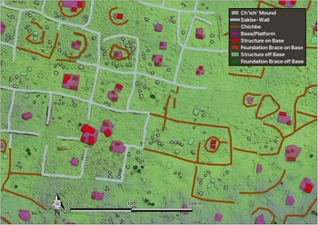
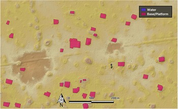
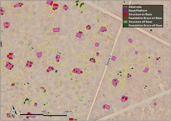
Lidar and ground reconnaissance indicate that Yaxuna has a very different pattern of domestic occupation from that of Coba. Although many of the differences may be attributed to the longer occupational history of Yaxuna, both sites share a robust domestic occupation in the Middle to Late Classic periods. Coba has a tendency toward walled domestic patio groups that are common at sites like Chunchucmil in the west and at sites in the southern Maya lowlands. Domestic architecture at Yaxuna, in contrast, is typified by broad platforms of the type common at sites to the northwest like Xcach toward the region of Izamal, and patio groups are nearly absent. Linear features such as albarradas are common at Coba but rare at Yaxuna where they appear to have been constructed during the colonial or postcolonial periods. Small cobble mounds (termed “ch’ich’ mounds”) are also very common at Coba, appearing to cluster around specific household groups away from the site center (Figure 2). Neither Yaxuna nor sites along Sacbe 1 have clusters of ch’ich’ mounds visible in the lidar data.
Ch’ich’ mounds at Coba visible in lidar. (Color online)

Figure 2 Long description
The thematic archaeological map of Cobá illustrates various features with a legend. Ch'ich' mounds are depicted as small dark dots, sabete wells as specific symbols and chichbes as outlined shapes. Stone platforms and structures are marked with red polygons, categorized as 'Structure on Base,' 'Foundation Brace on Base,' and 'Foundation Brace off Base.' The map shows clusters of ch'ich' mounds around household groups, with structures dispersed within outlined areas. North is oriented at the top, indicated by a north arrow. The scale bar provides reference for distance, enhancing spatial understanding. The map focuses on the distribution of archaeological features within the surveyed area of Cobá.
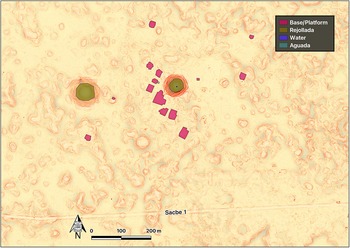
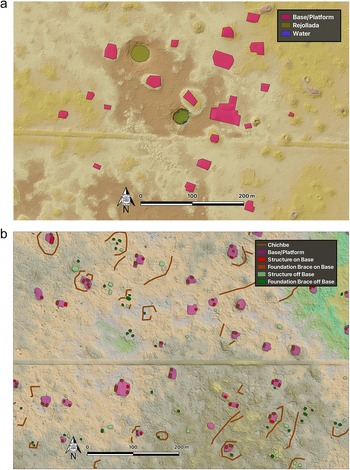
There are 26 archaeological sites along Sacbe 1 visible in the lidar imagery (Supplementary Material 1), in addition to the capitals at each end. This number is higher than that reported by Villa Rojas (Reference Villa Rojas1934), who did not systematically survey sites during his reconnaissance. We define a site as a cluster of five or more broad stone platforms or patio groups clearly visible in the lidar imagery. Oxkindzonot, which is located 6.2 km west of the Coba terminus and was first reported by Thompson and colleagues (Reference Thompson, Eric, Pollock and Charlot1932) as a separate site, is not included in the sample of 26 sites because we consider it part of Coba: settlement between it and the Coba site core is continuous. To define what counts as continuous, we used the kernel density tool in ArcGIS to suggest site boundaries and found that the natural breaks (Jenks) method with eight density classes yielded a break at a density of 32.3 groups per km2. This threshold aligns closely with the visibly intuitive density drop-off (Stanton et al. Reference Stanton, Hutson, Ardren, Chase, Chase and Chase2024). The threshold for the Coba site limit extends beyond the 104 km2 lidar block in two places: along Sacbe 1 and the other intersite sacbe to Ixil (see the later discussion). Sacbe 1 passes through 17 of these 26 sites and within 75 m of another. The causeway comes no closer than 200 m to the edge of the other eight sites that are identifiable in the survey. These eight sites (Figure 3) tend to be smaller than the ones through which the causeway passes, with an average of 10 versus 17 broad stone platforms or patio groups, a difference that is significant at the level of α = 0.05 (normal approximation of the Wilcoxon two-sample test, p = 0.0198).
One of eight hinterland sites along Sacbe 1 settled more than 200 m off the sacbe, northeast of Habin Cross indicated in Figure 1. (Color online)

Figure 3 Long description
The map displays archaeological features along Sacbe 1, with a legend indicating stone platforms, rejolladas, water bodies and aguadas. Stone platforms are marked in pink, distributed in clusters near the center. Rejolladas are shown in green, appearing as circular features. Water bodies are marked in blue, located near the stone platforms. Aguadas are indicated in purple, scattered throughout the area. The map includes a scale bar showing distances of 100 and 200 meters and a north arrow for orientation. Sacbe 1 is labeled, running horizontally across the map, indicating the path of the ancient causeway.
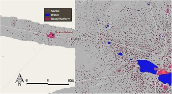
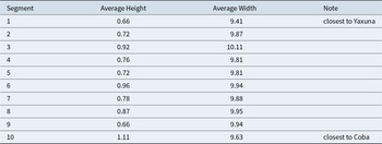
As seen in Figure 4, settlement extends west along Sacbe 1 for about 8 km as it leaves the urban core of Coba. This is in stark contrast to the last few kilometers outside Yaxuna, where there is no settlement along the sacbe and the sacbe itself is at its narrowest and lowest. The Oxkindzonot Group comprises range structures around very large plazas—both elements that suggest highly charged spaces for the gathering and display of goods or people (or both). A preliminary assessment of the site design based on lidar imagery suggests it was an administrative center connected to the rest of urban Coba; it was neither isolated nor independent of the main architectural centers of power. Domestic settlement consisting of household groups delineated by albarradas is continuous along Sacbe 1 between the Oxkindzonot Group and the center of urban Coba, whereas similar settlement drops off much sooner on all but one of the other sides of Coba. This one exception—settlement along Coba’s 20 km long Sacbe 24 to Ixil—proves the rule because it is the only other intersite causeway at Coba (Figure 4). An 800 m wide lidar transect in the direction of Ixil adds support for the expansion of the urban experience along intersite causeways.
Settlement along the sacbe west from Coba. (Color online)

Figure 4 Long description
The map illustrates settlement patterns along Sacbe west from Coba, with key features marked. Sacbe is indicated in gray, showing the path extending from Coba. Water bodies are marked in blue, scattered throughout the area, with larger concentrations near Coba. Bases/platforms are highlighted in pink, with notable clusters around Oxkindzonot and Coba. The map includes a scale bar for distance measurement and an arrow indicating north. The legend defines Sacbe, water and base/platform symbols, aiding in the interpretation of spatial distribution. Settlement is dense near Coba, with a gradual decrease moving westward along Sacbe.
Measuring Sacbe 1
In 1933, Alfonso Villa Rojas of the Carnegie Institution and 12 Maya men from the village of Chan Kom were the first team to systematically measure Sacbe 1. They spent 20 days on the causeway, clearing a path from Yaxuna to Coba and taking measurements with a Brunton compass and tape. Villa Rojas recovered six nearly identical inscribed stone dedication markers along the causeway between 5 and 13 km west of Coba that include a glyph for sakbih (SAK-BIH-hi; Stuart Reference Stuart2006:1). Although teams working at Coba and Yaxuna since the 1970s have improved on our knowledge of Sacbe 1 at each endpoint, the next substantial advance in knowledge of this causeway comes from the research reported here. There were many discoveries given the exquisite detail of lidar surveys, but one of the most interesting from the perspective of state-sponsored construction efforts was the large number of turns or deviations in the sacbe, especially given that Villa Rojas depicted the sacbe as nearly straight (Rohrer and Stanton Reference Rohrer, Stanton, Pennanen and Goosney2019). In fact, the sacbe meanders so much that it exits the bounds of the 1 km wide lidar transect in three locations. The 2017 and 2022 lidar captures enable us to measure the sacbe with unprecedented accuracy and precision.
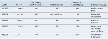
Sacbe 1 measures 99,072 m long. If one were to draw a straight line between the Coba and Yaxuna termini, the distance would be 98,060 m and the orientation 93°28’. The height and width of the causeway vary along its length. Using the eight DEMs that, when combined, capture the entirety of the causeway, we took width and height measurements every km (Supplementary Material 2). The average width is 9.84 m, ranging from 8.8 m to 10.7 m (stdev = 0.39 m). The average height is 0.82 m, ranging from 0.2 m to 1.5 m. The sacbe is highest in the first 3 km of its path within Coba. The total volume as preserved today is approximately 790,000 m3. This is about the same volume as the five largest monumental architectural complexes at Coba combined.
Sacbe 1 has five gaps (Table 1), totaling 942 m. Our measurement of its length (99,072 m) includes these gaps because we believe that the sacbe was originally built without breaks. All five gaps occur in human-built stone features such as ancient mounds and historic albarradas and buildings. The gaps likely result from stone robbing, done to provide material for those features, either during ancient times (at Ekal), historic times (at hacienda Sakaual), or both (at Bohé) (Table 2). Two tell-tale signs of scavenging are visible in the lidar imagery. First, the causeway is cut up into small fragments, which are clearly visible when comparing the west edges of X-Cahumil (Figure 5a) and Bohé (Figure 6) with a portion of the sacbe that was not disturbed (Figure 5b). The second indicator of stone robbing is the faint alignments that are still visible in the former path of the causeway, as at X-Cahumil (Figure 5a). Ancient scavenging has been demonstrated on the intersite causeway between Yaxuna and Tzacauil, establishing prehispanic precedent in the region (Hutson et al. Reference Hutson, Magnoni and Stanton2012). Given our argument that all five gaps in the causeway resulted from stone robbing, it follows that Sacbe 1 was a single construction project. The width is relatively consistent (9.8 m, stdev = 0.39 m) across the entire construction, suggesting a single plan. The width of the 20 km long Coba–Ixil causeway—6.2 m—is significantly different.
(a) Disturbed segment of Sacbe 1: the gap at X-Cahumil; (b) an undisturbed segment of Sacbe 1 within Coba. (Color online)

Figure 5 Long description
The image A showing a thematic map of a small mapped area with a legend listing three classes: “Base/Platform”, “Residuate” and “Water”. A straight linear feature runs horizontally across the map. Multiple polygon features are scattered across the map, with a denser grouping around the central area. Two small water features are shown near the central area. A north arrow is shown and a scale bar is labeled 0, 100 and 200 meters. The image B showing a thematic map of the same mapped area and the same horizontal linear feature. The legend lists five classes: “Chichbes”, “Structures on Base”, “Structures off Base”, “Residuates on Base” and “Residuates off Base”. Numerous small point symbols and polygon outlines are distributed across the map, including several clusters around the central area and additional scattered features toward the left and right sides. A north arrow is shown and a scale bar is labeled 0, 100 and 200 meters.
Disturbed segment of Sacbe 1: the gap at Bohe, an ancient site and historic ranch. (Color online)

Figure 6 Long description
A thematic site map with a legend listing two mapped feature types: “Water” and “Berm/Platform.” Water is shown with small blue symbols and berm/platform features are shown with red polygon symbols. The mapped area contains many red polygons of varying sizes distributed across the full extent of the map, including clusters in the central area and additional polygons toward the upper and lower edges. Several small blue water symbols appear near the central area. Map elements include a north arrow near the lower left, indicating north toward the top of the map. A scale bar near the bottom is labeled “0,” “100,” and “200 m.” No place names, coordinates, or title text are visible.
Average Dimensions of Causeway as Measured from Lidar Imagery (Each Segment Is Approximately 10 km Long).

Table 1 Long description
The table lists average height and average width from lidar measurements for 10 consecutive causeway segments, each about 10 kilometers long, with notes for the end segments. Average height ranges from 0.66 in segments 1 and 9 up to 1.11 in segment 10, which is noted as closest to Coba. Segment 6 is also relatively tall at 0.96, and segment 3 reaches 0.92. Average width varies less than height, spanning from 9.41 in segment 1, closest to Yaxuna, to 10.11 in segment 3. Most widths cluster around about 9.8 to 10.0, including 9.94 in segments 6 and 9 and 9.95 in segment 8. Overall, widths are fairly consistent along the route, while height fluctuates and peaks at the Coba end. Values are averages from lidar imagery, so local variation within each segment is not shown.
Locations and Lengths of Gaps in the Causeway.

Table 2 Long description
The table lists five causeway gaps with UTM x and y coordinates, distance in kilometers directly east of Yaxuna, an optional Villa Rojas kilometer marker, gap length in meters, and a brief site note. Gap lengths vary widely, from 38 meters at an unnamed ancient site to 460 meters at the ancient site of Ekal. The remaining gaps are 169 meters at Hacienda Sakaual, 168 meters at the ancient site and historic ranch of Bohe, and 107 meters at the ancient site of X-Cahumil. Distances east of Yaxuna span from 34.2 kilometers at Ekal to 59.4 kilometers at X-Cahumil, with the shortest gap occurring at 45.0 kilometers. Villa Rojas kilometer numbers are provided for four entries, while the unnamed ancient site has no Villa Rojas marker listed. Aside from the notably large gap at Ekal, the other gaps cluster within a relatively narrow range under 200 meters, and the table does not indicate why each gap occurs.
Not a Straight Line
As mentioned, an unanticipated result of the lidar mapping is the discovery of the many turns and bends in the route of Sacbe 1. There are 39 locations where the change in direction exceeds 3° (Supplementary Material 3). Of these, the largest change in direction is 17.5°, and the average change is 7.8°. To the west, the changes in direction usually occur at a single vertex, normally where the causeway crests a hummock (Rohrer and Stanton Reference Rohrer, Stanton, Pennanen and Goosney2019). To the east, where the terrain has far fewer hills, the changes in direction are mostly gentle curves or bends. What explains these changes in direction? Rohrer and Stanton (Reference Rohrer, Stanton, Pennanen and Goosney2019) note that direction changes at the top of a hummock may relate to engineering concerns. Convincing evidence of engineering skill can be found in the dozens of places when the causeway crosses a hummock without changing direction. Hummocks 3 m tall or greater presented an engineering challenge because a straight line of sight was extended over the top of the hill and down the other side to maintain a constant orientation. We suggest turns must have resulted from intentional planning, semi-intentional lapses in the standards of rectitude achieved elsewhere on the causeway as an act of resistance rather than ineptitude, or the existence of different work crews with varying levels of skills, commitment, or both.
One purpose of intentionally planned turns is to link already existing sites that are not in alignment. These linkages advance the geopolitical aims of an expansive Coba dynasty. For example, at the Coba end of the causeway, as Sacbe 1 progresses west beyond the outer edges of Coba at Oxkindzonot, its path takes several small deviations that enable it to connect a series of sites that are not exactly aligned and therefore could not be linked by a perfectly straight causeway. Eventually, at a distance of 31.2 km from the Coba terminus, the causeway makes a substantial turn at the major site of Kauan. The turn consists of a series of gradual curves over the course of about 2 km, which reorient the causeway from a bearing of about 280° to 259° as the causeway changes direction to connect with the next two sites along the sacbe—Xcahumil (38.5 km west of Coba) and Bohé (41.8 km west of Coba)—both of which have monumental architecture and substantial residential settlement. Likewise, about 4.9 km east of Yaxuna, the sacbe makes its first turn, executing an 11.85° adjustment to the right (if walking toward Coba) in the direction of a cluster of four small sites and a potential ballcourt located between 10 and 14 km east of Yaxuna. Then, in the middle of this cluster of settlements, it turns 10.2° to the left in the direction of a site located 24 km east of Yaxuna.
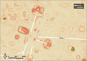
Additional motivations for the deviations of Sacbe 1 are to accommodate natural features like cenotes and aguadas, which could have secured access to water resources for the expanding Coba state and thirsty travelers. In many cases, such features are associated with settlement clusters, such as at the sites of Ekal and Sisal. However, there are small cenotes and other water-holding features near the sacbe that have little to no discernible architecture. For example, 43.3 km east of Yaxuna are found a small cenote and a large rejollada, with a likely cave entrance just north of the sacbe (Figure 7). In its path westward toward Yaxuna, the sacbe reaches these features by veering to the left/south. Soon after passing the rejollada and cenote, about 500 m to the west of the cenote, the sacbe turns 13.9° to the right/north as part of a series of course corrections that bring the sacbe back in the direction of Yaxuna. This area in general appears to contain a concentration of rejolladas: about half (77 of 153) the rejolladas we identified along Sacbe 1 (not including within the bounds of Yaxuna and Coba) lie within the approximately 20 km stretch between Ekal and Sakaual, or roughly 35–55 km east of Yaxuna. Given the propensity for growing economically important crops in rejolladas (Kepecs and Boucher Reference Kepecs, Sylviane and Fedick1996; Munro-Stasiuk et al. Reference Munro-Stasiuk, T. Kam, Trent and Traci2014), the density of rejolladas here may have not only affected the course of the sacbe but also incentivized its construction to secure additional agricultural lands for the growing Coba polity.
Small cenote and possible cave entrance with no associated architecture or settlement along the north side of Sacbe 1. (Color online)

Figure 7 Long description
The map displays Sacbe 1, a pathway running horizontally across the terrain. Two water bodies are marked: a cenote and a rejollada. The cenote is labeled in blue, located near the path. The rejollada is shown in green, indicating water presence. The map includes a legend with two categories: 'Rejollada' in green and 'Water' in blue. Terrain features are visible, with elevations and depressions marked. A scale bar at the bottom indicates distances of 100 and 200 meters, with a north directional arrow for orientation.
Lidar imagery reveals many small depressions clustered along the sides of Sacbe 1, likely the result of extraction of limestone and sascab, the materials needed for sacbe construction. After such pits were exhausted of material, the remaining hollows provided excellent water containers, conveniently situated alongside the roadway for the needs of travelers moving from settlement to settlement, at least during the rainy season. As Houck (Reference Houck, Mathews and Morrison2006) noted, natural resources are highly localized in the northern Maya lowlands and water sources, and soil quality can vary significantly as one moved across the region. We suggest that the construction of Sacbe 1 was intrinsically related to the direct or indirect control of natural resources needed by the growing urban population of Coba.
Yet many of the causeway’s changes in direction do not make sense if the goal is simply to link towns and villages between Coba and Yaxuna or to maximize agricultural potential. For example, the 7.3 km stretch between Kauan and X-Cahumil contains no settlements to be linked nor any obstacles (such as sinkholes) to avoid; the builders could have built the causeway there in a straight line. Yet it changes direction three times between the two sites, making turns, as one walks westward, of 9.47° to the left, 6.42° to the right, and 7.82° to the right. The fact that the causeway runs perfectly straight for several kilometers in other places means that at least some of its builders had the ability to orient the causeway along a straight line. Doing so would have yielded economies in building materials and labor such as forest clearing. The curves between Kauan and X-Cahumil, and similar ones elsewhere, appear to be desultory or at least opaque given the political and natural landscape. It is likely that different work crews were in charge of constructing different parts of Sacbe 1; perhaps these deviations resulted from difficulties coordinating between work groups.
To explain similarly desultory curves on the Uci intersite causeways, Hutson and Welch (Reference Hutson and Welch2021) proposed that some work crews invested more in causeway construction than other crews. Perhaps at Coba, some work crews dedicated themselves more to the job, and others were less concerned with perfection or less invested in executing Coba’s state ideologies. Because these apparently desultory curves are gradual, they would be difficult to notice on the ground; indeed, Villa Rojas (Reference Villa Rojas1934) overlooked many. Thus, the less exacting work would be largely hidden: it would be a fugitive transcript of resistance to the state. In this light, causeway construction may have been a negotiation: disaffected laborers (perhaps conscripted from Yaxuna or settlements along the sacbe) exercised a degree of agency while Coba’s leaders still got what they wanted in the end. We acknowledge that many other factors may have affected sacbe construction, including seasonal conditions, labor availability, or the agendas of individual hinterland settlements. We favor an explanation that takes into consideration the high degree of skill demonstrated in the construction of most of Sacbe 1 and assigns a degree of agency to workers responsible for stretches of uneven execution.
Chronological Considerations
Pinpointing the exact date of Sacbe 1 construction has proven challenging and requires further research. We have no chronometric dates from the causeway itself, although we believe that available settlement and epigraphic evidence points to its construction and use sometime during the sixth to eighth centuries AD. Ceramic data from excavations associated with the causeway have proven inconclusive. The vast majority of settlement that has been tested at Coba dates to the period in which Palmas Complex (AD 550/600–700/730) ceramics were in use, indicating that the urban expansion of Coba, which we suspect included the causeway, dates to this period (Robles C. Reference Robles1990; Stanton et al. Reference Stanton, Hutson, Ardren, Chase, Chase and Chase2024). In addition, the corpus of hieroglyphic texts at Coba is restricted to dates from approximately AD 550–780 (Esparza Olguín Reference Olguín and Octavio2016). Construction of Sacbe 1 was such a resource-intensive undertaking that we suggest it most likely dates to the height of urban life and dynastic power at the site (when Palmas Complex ceramics were in use).
At Yaxuna, ceramics dating to the Yulum Complex (AD 450–700 based on 100 AMS dates) have been found in sacbe fill and in terminal contexts associated with the causeway (Stanton et al. Reference Stanton, Ardren, Barth, Fernandez-Diaz, Rohrer, Meyer and Miller2020). Robles C. (Reference Robles1990), however, associated Sacbe 1 at Coba with the Oro Complex (AD 700/730–1100/1200), but there are no published descriptions of the excavations carried out in the area of Sacbe 1 by his project. Although a unit was excavated into Sacbe 1 at Coba, data from it are not separated out in Robles’s ceramic publication. Five AMS dates run on animal bone from one context are known for Coba: these all have ranges within AD 420–600 and are associated with Palmas Complex ceramic materials, suggesting that, like the Yulum Complex at Yaxuna, Palmas may begin before AD 550.
We do have limited chronological data from off-mound test pitting and architectural excavations at Coba and Yaxuna, and some chronological patterns have emerged. Even though Yaxuna had a much longer occupation—from about 1000 BC to AD 1200—than is currently known for Coba, the settlement at Yaxuna is substantially smaller, both in terms of aerial extent and the number of architectural features visible in the lidar. Its aerial extent is roughly 2.3 km2 compared to approximately 75 km2 at Coba based on new determinations; we recently calculated the Palmas Complex period population as between 60,000 to 90,000 at Coba, whereas the number of people at Yaxuna may have been well under 10,000, if not less than 5,000 (Stanton et al. Reference Stanton, Hutson, Ardren, Chase, Chase and Chase2024). Coba has a prehispanic occupation dating to as early as the Late Preclassic and as late as the Late Postclassic; yet, based on prior research and our own excavations, most of the occupation dates to the Palmas Complex (Stanton et al. Reference Stanton, Hutson, Ardren, Chase, Chase and Chase2024). This indicates that in contrast to the rather continuous occupation at Yaxuna, Coba experienced a tremendous burst of urbanization around the sixth and seventh centuries, and the urban experience of Coba was much more complex and expansive than that at Yaxuna.
Differences between Yaxuna and Coba go beyond the scale of the settlements, however. Early Yaxuna is characterized by architecture that shows deep connections to cities in the southern lowlands that have triadic groups and E-Groups (Stanton and Freidel Reference Stanton and Freidel2005). Later, other architectural influences can be seen in standing architecture and lidar data, especially those related to Puuc-style traditions common in the western portion of the peninsula during the eighth and ninth centuries AD, including an Early Puuc Ceremonial Complex (Novelo Rincón Reference Rincón and Gustavo2012). Although Coba has also been characterized as having architectural ties to the south (especially in reference to the steep Peten-style temples), the civic architecture is quite distinct from other areas of the Maya lowlands. Each of the monumental groups is different, but there are numerous groups with temples that are enclosed by fairly substantial walls with very little else in the plazas. These monumental groups are integrated within the intra-site causeway system, but whether they might have functioned as mortuary complexes, markets, administrative units, or some combination remains to be investigated.
Albarradas are found throughout the study area but are difficult to date. Clearly, some of these linear features are associated with modern and historic constructions, given their morphology (often forming larger rectangular features), spatial association with modern or historic ranches and haciendas, and articulation with prehispanic constructions. Thus, we can eliminate a sizable number of these features from our analyses of Preclassic to Postclassic contexts. Although there appear to be some sites outside Coba that have evidence of albarradas dating to prehispanic times in the lidar data, these features are overwhelmingly concentrated around the eastern terminus of Sacbe 1. In fact, as mentioned earlier, west of Hay-Dzonot we cannot identify any substantial evidence of albarradas, which we interpret as a significant marker of cultural difference.
Historical Context and Ambition
Coba was one of the largest and most politically influential polities of the Classic Maya northern lowlands. Although the extremely weathered surfaces of Coba stelae have discouraged many epigraphers from grappling with the dynastic sequence, Stanley Guenter (Reference Guenter and Stanton2014) identified a seventh-century queen from Coba who carried the kaloomte’ , or supreme title of independent authoritarian rule (see also Esparza Olguín Reference Olguín and Octavio2016). The presence of this title in the hieroglyphic record indicates that Coba was one of the most powerful cities in the seventh century AD; Simon Martin (Reference Martin2020:81) also points out that Coba used the kaloomte’ title earlier than other Maya cities. A large number of carved stelae from Coba have dates that cluster between AD 613 and 780, with the monumental core emerging in the Early Classic and growing to full elaboration in the Palmas phase (AD 550/600–700/730), as mentioned earlier. Further suggestions about the political importance of Coba come from the presence of an aj koba’—a “Coba person”—recorded as a captive on Edzna stela 18 from 692 (Grube Reference Grube and Hanns2003:360; Martin Reference Martin2020:421) and the capture of someone carrying the Oxkintok royal title on Coba stela 6 (Martin Reference Martin2020:421). These passages and the immense size of Coba suggest it was the preeminent political power when the Late Classic period began in the northern Maya lowlands.
In addition to anchoring the longest intersite sacbe, Coba has an impressive number of intra-site causeways. Benavides Castillo (Reference Benavides Castillo1981:68) identified more than 45 raised causeways at Coba during his mapping and excavation project in the late 1970s, and the limited research that has continued at the site since then has increased this number incrementally. Coba’s sacbes crisscross the site, and many connect the city center with elite residential structures located several kilometers away. The network of internal roads at Coba is so complex that architects created additional integrative features such as ramps and crossroads to facilitate movement from one sacbe to another or around an immovable natural feature (Folan et al. Reference Folan, Kintz and Fletcher1983:84–85). Sacbes were as integral a feature of Coba urbanism and the experience of urban life as monumental architecture.
Sacbe 2 at Coba is a good example of how raised roads replicated social inequalities inherent to urban life. This 10 m wide causeway runs from the Chumuk Mul monumental group at the heart of downtown Coba, north through a zone of modest residential structures. The road is more than 3 km long, intersects with Sacbe 1 that leads to Yaxuna, continues directly north, and eventually ends at an elite residential platform known as Los Altares. Along the length of Sacbe 2 are nine small platforms that range from 5 to 20 m on a side (Benavides Castillo Reference Benavides Castillo1981:112). These platforms do not have any associated architecture and few artifacts, so they have been interpreted as areas for devotion, rest, or administration of roads and associated resources (Bolles and Folan Reference Bolles and Folan2001:306, Chase and Chase Reference Chase and Chase2001:277, Shaw Reference Shaw2008:76, Villa Rojas Reference Villa Rojas1934:205).
As it travels north from the city center, Sacbe 2 passes through dense residential settlement of walled household groups (Folan et al. Reference Folan, Kintz and Fletcher1983; Stanton et al. Reference Stanton, Ardren, Barth, Diaz, Miller, Taube, Rohrer, Guderjan and Mathews2023; see Figure 8). Each group was made up of two to three platforms supporting modest residential structures situated around a common patio area. Walled residential groups are rare in the Maya area, but soil studies (Hutson Reference Hutson2010) have shown that domestic compounds were the settings for many of the same activities in the Classic period as modern Yucatec solares or domestic gardens: at Chunchucmil, soils contain the botanical and artifactual residues of arboriculture and craft production. Thus, the landscape traversed by Sacbe 2 and other urban sacbes at Coba was likely economically productive. Coba’s leaders extracted surplus from the thousands of households in the city. Insofar as causeways represented large investments of labor, connected monumental architectural complexes, and were commissioned by Coba’s leaders, they stood as ever-present reminders of Coba’s power to extract resources and control movement.
Walled household groups north along Sacbe 2. (Color online)

Figure 8 Long description
The map is a thematic site plan depicting the distribution of walled household groups and associated structures along Sacbe 2. The north arrow is positioned in the lower left corner of the map. A scale bar is present, indicating distances of 100 meters and 200 meters. Two diagonal road lines are visible crossing the map, with Sacbe 2 identifiable as a prominent reference feature running through the mapped area. The legend contains six categories: Abandonada, Base/Platform, Structure on Base, Foundation Brace on Base, Structure off Base and Foundation Brace off Base. Each category is represented by a distinct symbol: Abandonada is marked with a small outlined square; Base/Platform is shown as a filled rectangle; Structure on Base appears as a solid filled shape placed within a base outline; Foundation Brace on Base is represented by a hatched or patterned shape on a base; Structure off Base is a solid filled shape without an enclosing base outline; Foundation Brace off Base is a hatched or patterned shape without a base outline. Structures and bases are distributed across the mapped area, with denser clustering visible in the central and northern portions of the map, particularly in proximity to Sacbe 2. Sparser distribution is observed toward the outer edges of the mapped area. Several grouped arrangements of shapes are visible, where multiple symbols appear in close proximity, indicating compound-style groupings. No administrative place names or coordinates are explicitly labeled on the map.
A very powerful Coba queen ruled during a period contemporary with the construction of Sacbe 1 (Guenter Reference Guenter and Stanton2014; Martin Reference Martin2020). Eight stelae from the Macanxoc area of the site are slightly better preserved than many of the others at Coba, and five contain portraits of female rulers. Guenter (Reference Guenter and Stanton2014) suggests that Lady K’awiil Ajaw is titled as a kaloomte’, or supreme warlord on Stela 1. Given the fact that she is associated with the opening Long Count date on that monument, which Stuart has identified as the 13 tun anniversary of an accession mentioned on Stela 4, it is hard to escape the conclusion that this accession is that of Lady K’awiil Ajaw herself and that she is Stuart’s “Ruler B.” The two Long Count dates on the front of Stela 1 are 9.11.0.5.9, 4 Muluc 17 Kayab (January 26, 653) and 9.12.10.5.12, 4 Eb 10 Yax (August 25, 682; Guenter Reference Guenter and Stanton2014:398). Kaloomte’ titles are associated with warfare and territorial expansion, and Stelae 1, 2, 4, and 5 from the Macanxoc group include images of captives, suggesting that territorial expansion and possible subjugation of neighboring elites occurred during Lady K’awiil Ajaw’s reign and were part of her claims to power. K’awiil Ajaw is believed to have been one of the many powerful stranger queens in Late Classic Maya history: royal women from high-ranking elite lineages who left their families of origin to rule at subordinate cities and expand the power and resources of their lineage (Ardren Reference Ardren, McAnany and Masson2025). Such women often took extraordinary actions, given their status as outsiders imbued with spiritual and political authority.
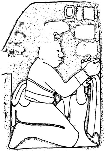
A small carved stone panel found in 1979 suggests that the aggressive ambitions of the Coba elites who ordered the construction of Sacbe 1 may have been communicated to the population who lived alongside it. This rectangular panel, approximately 1.0 × 0.7 m, depicts a bound captive and was found on a small platform adjacent to Sacbe 1 that no longer exists but was located 5 km west of the terminus of Sacbe 1 in Coba (Figure 9; Brasdefer Reference Brasderfer1981:53–54). The panel is nearly identical to two others found in the ballcourt located between the Nohoch Mul and Coba groups, in an area near the eastern terminus of Sacbe 1 (Brasdefer Reference Brasderfer1981:53). Clearly the capture and humiliation of elite prisoners were themes commemorated in the art of Coba: these images were placed at key locations associated with Sacbe 1, including where one would have entered the city if arriving via the causeway from Yaxuna and in the vicinity of its termination point. In concert with the stelae located in the Macanxoc Group where Sacbe 1 terminates, Lady K’awiil Ajaw may have used state resources to commission and place images of captives along the sacbe to convey her control of the region.
Image of captive from Nachi Cocom platform west of Coba (after Brasderfer Reference Brasderfer1981).

Figure 9 Long description
A carved relief illustration in outline style shows a kneeling human figure facing right. The figure’s arms are held forward, with a looped restraint around the wrists and a long trailing band. A strap crosses the torso and a curved band runs behind the back. The head is shown in profile with a rounded ear ornament and a short hairline or cap shape. To the right of the figure is a tall vertical frame with an inner border; the figure’s hands are positioned near this frame. Above the figure, near the top edge, are several rectangular blocks arranged in a row. The overall tone is subdued, with the figure shown restrained and kneeling.
In a study of the Coba dynastic sequence, Gronemeyer (Reference Gronemeyer2004:6) suggested that an emblem glyph appears frequently in the inscriptions of Coba that could be associated with Yaxuna, given the linkage of the two sites via Sacbe 1. A female personal name is associated with this emblem glyph, and Gronemeyer suggests that it is possible someone from the site referenced with the mysterious emblem glyph may have married into the Coba dynasty. Taken together, these three epigraphic and iconographic contributions to the history of Coba—the presence of a queen at Coba carrying the kaloomte’ holy warlord title, the prisoner panel along Sacbe 1, and the possibility of a previously unknown marriage alliance mentioned in the hieroglyphic record of Coba—enhance our understanding of the complicated political relationship between Coba and Yaxuna. A picture begins to emerge of bellicose dynastic relations and territorial struggles among the cities of the north. It is likely that the performance of war using ideologically charged spatial settings such as Sacbe 1 has a longer history in the northern lowlands than often presumed, beginning as early as AD 600.
There is little evidence from Yaxuna to confirm or disprove that prisoners might have been taken from the city and paraded along the sacbe back to Coba. At Yaxuna, Sacbe 1 ends at a modest Early Classic platform that was refurbished with the arrival of the raised road and then reused again in the Postclassic period (Ardren Reference Ardren2003). Although this structure is ordinary, it is aligned with Structure 6E-14, a small radial structure adjacent to the Preclassic E-Group, which is the sacred center of Classic period Yaxuna (Figure 10; Stanton and Freidel Reference Stanton and Freidel2005). If Sacbe 1 was commissioned by Lady K’awiil Ajaw, she very strategically chose one of the most symbolically charged locations within the heart of urban Yaxuna for the terminus of her raised road. Sacbe 1 quite clearly tied Yaxuna to Coba and bound it and the intervening hinterland to the ambitions of the Coba dynasty.
Map of central Yaxuna showing Sacbe 1 terminus. (Color online)

Figure 10 Long description
Insufficient visual information to describe this element accurately.
Discussion and Conclusion
Sacbe 1 is a monumental piece of infrastructure that functioned in multivocalic ways. We suggest that one of its most salient characteristics is as an attempt by the leaders of Coba not only to claim hinterland to the west but also to do so by replicating the spatial and social inequalities inherent to urban life. Using this massive road in numerous ways, the occupants of Coba, Yaxuna, and the intervening hinterland had an embodied and daily experience of the power of the state to control human and natural resources. From the perspective of cost, the sacbe used about as much rock, plaster, and sascab as Coba’s five largest monumental compounds combined—and thus represents the single largest state expenditure, by far, in the history of this dynasty. Securing such resources involved the control of quarries, distribution routes, and craftspeople at a massive scale. The occupants of the two cities that anchored the road and those settlements along it saw Sacbe 1 emerge from the forest and fields, and as they navigated around it or on it every day, they were reminded of the extraordinary power of the seventh-century royal dynasties that commissioned such a masterpiece of engineering. This knowledge contributed to a sense of belonging—consensual or not—to a particular place and set of ruling powers.
Construction of Sacbe 1 helped create a shared urban identity that facilitated the control that leaders of Coba exerted over the population of the central peninsula from AD 500 to 800. We suggest evidence that supports a model whereby leaders of Coba, perhaps especially the ambitious Queen K’awiil Ajaw, identified an opportunity to expand the territory of her polity westward into the center of the peninsula. Aiming for the small but long-surviving ancient city of Yaxuna, engineers from Coba organized groups of corvee labor that executed construction with varying levels of skill. Our research shows that the sacbe is tallest and most massive at Coba and the shortest and narrowest at Yaxuna, which suggests that the 60,000–90,000 citizens of Coba were as much a target for the message of state power through massive and innovative construction projects as were the smaller populations at Yaxuna or sites along the roadway (Stanton et al. Reference Stanton, Hutson, Ardren, Chase, Chase and Chase2024:117). We argue that the deviations in the orientation of the road were created by separate work parties that were supervised independently. Some deviations might be attributed to difficulties in coordinating multiple work groups or the need to link unaligned settlements and control natural resources such as water and sascab. Still others may be the result of resistance to the forced construction of the road. Workers in some areas where deviations are great may have actively underperformed in their adherence to engineering expectations to undermine, if covertly, the project in small but meaningful ways.
It is worth considering why Sacbe 1 was constructed in the particular landscape west of Coba. We have provided hints of a possible marriage alliance between the royals of Coba and Yaxuna, and it is well established that Yaxuna had ties to the western part of the peninsula, including the dynasty of Oxkintok in the sixth century (Tiesler et al. Reference Tiesler, Cucina, Stanton and Freidel2017). Although there are 26 sites along the length of the causeway, all are smaller than Yaxuna and much smaller than Coba. Therefore, it is unlikely that any were dynastic centers. The royal city of Ek’ Balam, however, is only 75 km to the north of Coba. Perhaps, rather than looking at Sacbe 1 as evidence only of Coba’s expansiveness, we should also explore where opponents of the Coba dynasty might have impeded such a massive undertaking. The kingdom of Ek’ Balam may have been a well-protected opponent not worth provoking, and although it reached its peak under Ukit Kan Lek Took in the late eighth century, it was likely a substantial settlement before that and was contemporary with the construction of Sacbe 1. Much more research is needed at the sites along Sacbe 1, but only a few seem to have been constructed at the same time as the sacbe itself. We do not know what forms of resistance the populations of these centers were able to muster, if any, but when large infrastructure projects impinge on earlier construction, it is often the result of power imbalances and the inability of existing communities to effectively say no.
Urban environments are constructed from unique spatial relationships that rely on shared understandings and agreements. One learned what it meant to live in Coba or Yaxuna through the experience of uniquely urban spaces such as sacbes, whether as ritualist, warrior, pilgrim, or spectator. These kinds of distinctive, creative, and content-rich experiences were frequent and ubiquitous for the urban citizen. Consequently, city dwellers not only expected such spatialized relations to be part of their urban experience but they also held the knowledge that other citizens of their city shared these same experiences or the potential for these experiences. Finally, it is urban citizens who plan, rehearse, and ultimately perform ritual processions or war preparations that reference and reinforce the specialized life of cities. The exchange of specialized knowledge about how sacbes could be used, what they referenced, and why certain individuals had the opportunity or obligation to participate should be understood to comprise a fundamental element of how urban life was both experienced and reproduced in Classic Maya times.
Acknowledgments
We thank the Consejo de Arqueología of the Instituto Nacional de Antropología e Historia for granting the permits to conduct this research; all data are the cultural patrimony of Mexico. We also appreciate the support and guidance that María José Con Uribe, José Manuel Ochoa Rodríguez, and Fernando Robles Castellanos provided us as we worked at Coba. Most importantly, we thank the communities of Coba, Nuevo Xcan, San Juan, San Pedro, and Yaxunah for allowing us to conduct research in their ejidos, as well as the landowners of the ranch at Ekal. We thank three reviewers for their constructive feedback and Daniel Vallejo-Cáliz for translation of our abstract.
Funding Statement
This research was generously supported by the National Science Foundation (#1623603), Jerry Murdock, Fundación Roberto Hernández, Selz Foundation, and Research Fellowships to Ardren from Dumbarton Oaks and the Center for the Humanities at the University of Miami.
Data Availability Statement
The lidar data used in this study are permanently stored at the Eastern Information Center (EIC) at the University of California Riverside. Access to these data (accession number EIC2016-TS01) can be arranged by contacting Travis Stanton.
Competing Interests
The authors declare none.
Supplementary Material
The supplementary material for this article can be found at https://doi.org/10.1017/laq.2024.47.
Supplementary Material 1. Preliminary data on sites near the Yaxuna-Coba causeway that are visible on the lidar imagery commissioned for and analyzed in this article (table).
Supplementary Material 2. Lidar-based measurements of the Yaxuna-Coba causeway taken approximately every kilometer. “Segment” refers to arbitrarily selected 10 km long segments of the causeway, with segment 1 beginning at Yaxuna and segment 10 ending at Coba (table).
Supplementary Material 3. Details of the most noticeable changes in direction in the Yaxuna-Coba causeway (table).


 Open access