


The Sunda pangolin Manis javanica, native to Southeast Asia, is severely threatened by poaching and the loss of forest and shrubland habitat. It is categorized as Critically Endangered on the IUCN Red List and in the Singapore Red Data Book (Lim et al., Reference Lim, Subaraj, Yeo, Lim, Lane, Lee, Davison, Ng and Ho2008; Challender et al., Reference Challender, Willcox, Panjang, Lim, Nash, Heinrich and Chong2019). In the highly urbanized island city-state of Singapore, the species appears to be mostly confined to forested nature reserves, nature parks, the western catchment area and the offshore islands of Ubin and Tekong (Teo & Rajathurai, Reference Teo and Rajathurai1997; Baker & Lim, Reference Baker and Lim2012; Lim et al., Reference Lim, Chua and Lim2016). Hunting is the primary threat across most of its range in Southeast Asia, but in Singapore the major threats are habitat loss and fragmentation, and collisions with vehicles (Lee et al., Reference Lee, Chung, Nash, Lim, Chan, Luz and Lees2018; Challender et al., Reference Challender, Willcox, Panjang, Lim, Nash, Heinrich and Chong2019). The urban ecology of the Sunda pangolin in Singapore is poorly understood, as studies have focused primarily on its natural habitats (Teo & Rajathurai, Reference Teo and Rajathurai1997; Lim & Ng, Reference Lim and Ng2008; Nash, Reference Nash2018; Teo & Thomas, Reference Teo and Thomas2019).
To address the conservation needs of the species in Singapore, the Singapore Pangolin Working Group was established in 2014, bringing together public and private stakeholders involved in pangolin research and conservation (Nash et al., Reference Nash, Lee, Lim, Luz, Li, Chung, Challender, Nash and Waterman2020). In 2018, the Group published the Sunda Pangolin National Conservation Strategy and Action Plan (Lee et al., Reference Lee, Chung, Nash, Lim, Chan, Luz and Lees2018), setting out five key goals. Goal 1 of the Action Plan is to gather and share information on the species’ status, ecology, biology and behaviour, including improving knowledge of its urban ecology. Understanding the distribution of Sunda pangolins within the city and analysing roadkill and rescue locations by mapping occurrence data will contribute towards this goal.
Georeferenced wildlife data are valuable for generating distribution maps of rare species and for examining the ecological implications of wildlife mortality (Steyaert et al., Reference Steyaert, Zedrosser, Elfström, Ordiz, Leclerc and Frank2016; Thinley et al., Reference Thinley, Norbu, Rajaratnam, Vernes, Wangdi and Tshering2019). Analysing pangolin occurrence data in Singapore can be challenging because the data are typically collected opportunistically by various stakeholders in a non-standardized manner. These data include records of live sightings, injured pangolins that have been rescued, and pangolins that have been killed in collisions with vehicles, but they often lack geographical coordinates. Difficulties in interpreting locality descriptions could therefore limit attempts to use these data to guide conservation strategies.
Here we consolidate available Sunda pangolin occurrence data from Singapore Pangolin Working Group member organizations and open-source mining of mainstream and social media to create a georeferenced database (Supplementary Material 1; Supplementary Tables 1 & 2). We also develop a method for converting locality descriptions into geographical coordinates using georeferencing best practices (Chapman & Wieczorek, Reference Chapman and Wieczorek2020). We demonstrate the use of this database to analyse pangolin rescue and roadkill incidents to aid conservation of this species in Singapore, and describe other potential applications.
We georeferenced 482 Sunda pangolin records from September 1996 to June 2021 (Fig. 1). Of these, 220 were rescues, 96 were roadkill and 166 were sightings. The majority of the records were from 2011 onwards (84%; Supplemen tary Table 3).
Generated coordinates of Sunda pangolin records in Singapore from September 1996 to June 2021, showing roadkills, rescues and sightings. (Readers of the printed journal are referred to the online article for a colour version of this figure.)
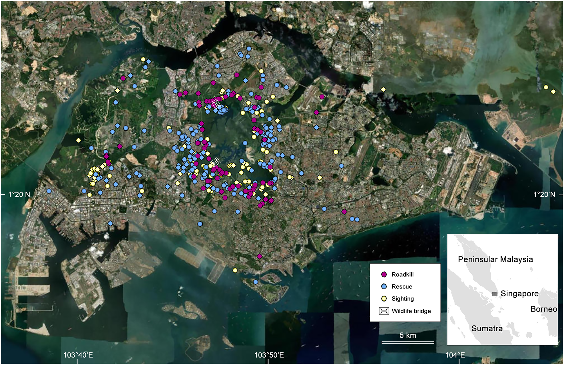
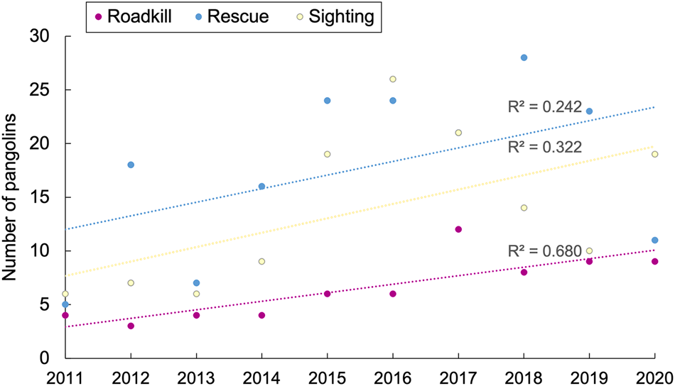
Pangolin rescue and roadkill incidents mostly occurred in central and western Singapore, close to forested areas where the nature reserves and water catchment are located (Fig. 1), but many rescues were also reported away from core forested sites. Regression analyses indicated an increase in all types of Sunda pangolin observations from 2011 to 2020 (Fig. 2), with reports of roadkill showing the strongest increase (R2 = 0.680) compared to sightings (R2 = 0.322) and rescues (R2 = 0.242).
Biplot of Sunda pangolin rescues, roadkills and sightings during 2011–2020 in Singapore (Fig. 1) with the associated R2 values.
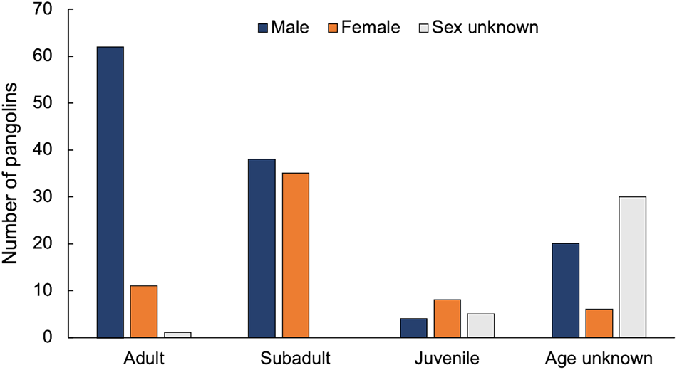
We found that male pangolins were twice as likely to be rescued compared to females (Fig. 3; χ 2 = 10.8, P < 0.01). Adult males (28%) were most regularly rescued, followed by subadult males (17%) and subadult females (16%). There were statistically significant differences between the number of male adults rescued compared to subadults of both sexes (χ 2 = 5.58 male, χ 2 = 19.46 female; P < 0.01 for both). However, there was no significant difference between the number of male and female subadults rescued (χ 2 = 0.11, P < 0.05). This sex bias is mirrored in roadkill records, with 3.6 times more male pangolins being reported as roadkill than females (Supplementary Table 4), although only 23 (24%) of the 96 roadkill records included details of the individual's sex.
Sunda pangolin rescues in Singapore from September 1996 to June 2021 by sex and age.
This is the first georeferenced database of Sunda pangolin records from Singapore. It will be of value for conservation management and for improving our knowledge of pangolin biology. For example, wildlife rescue and rehabilitation efforts will need to adapt to the increasing number of pangolins requiring rescue. During 2015–2021, 67% of all rescued pangolins in Singapore were successfully treated and returned to the wild (Yeong, Reference Yeong2022). The continued strengthening of this rehabilitation network and the capacity to care for increasing numbers of rescued individuals are crucial for the conservation and management of the species in Singapore. The rescue and rehabilitation process also provides a unique opportunity to gain a better understanding of the health of Sunda pangolins in Singapore and advance veterinary care of the species (Yeong, Reference Yeong2022; Heng et al., Reference Heng, Yeong, Yeo and Mathew2023). However, further studies are needed to determine whether the increase in rescued individuals represents a rise in the number of pangolins requiring rescue, increased rescue capacity or more public reporting.
Our finding that many pangolin rescues and roadkill occur along the fringes of core forested areas can help indicate hotspot areas where mitigation actions should be focused. These actions could include erecting barriers at road sides, creating wildlife crossings to improve ecological connectivity, and implementing animal detection systems for motorists. Such measures have been shown to reduce wildlife mortality elsewhere (Rytwinski et al., Reference Rytwinski, Soanes, Jaeger, Fahrig, Findlay and Houlahan2016). Of the two current wildlife bridges in Singapore (Fig. 1), at least one is known to be used by Sunda pangolins (NParks, Reference NParks2015). An underground culvert along Rifle Range Road has also been used by pangolins for crossing (NParks, unpubl. data, 2023), suggesting similar structures could be beneficial at rescue and roadkill hotspots. Identifying these hotspots can also aid public outreach efforts to encourage wildlife-friendly driving or increased reporting of distressed animals. Although hotspot identification was not our initial focus in creating this database, it is a useful starting point for further studies.
We found that subadults and adult males were rescued most often and were the main roadkill victims. This could be because of their dispersal or roaming behaviour, with movement outside forests and into urban areas putting them at a higher risk of collision with vehicles. This behaviour is consistent with that seen in Temminck's ground pangolins Smutsia temminckii: males travel further than females and young pangolins sometimes travel tens of kilometres before establishing a stable home range (Pietersen et al., Reference Pietersen, McKechnie and Jansen2014). Gray et al. (Reference Gray, Van Le, Thi Thanh Nguyen, Nhat Cau, Van Nguyen and Van Pham2023) found no statistical difference in daily movement between Sunda pangolin sexes, but on average males moved longer distances. Threat mitigation and post-rescue release strategies could focus on at-risk groups (e.g. releasing adult males far away from urban areas) to help achieve better conservation outcomes.
The presence of pangolins in the urban environment far from core forested areas indicates they sometimes foray into more urbanized areas of Singapore before being seen or requiring rescue. How they move through the city remains unclear because there is insufficient knowledge of the species’ ecology, such as its dispersal ability and response to habitat disturbance. Further research using telemetry or camera traps could reveal movement pathways and inform pangolin rescue strategies.
This database has already been put to use for pangolin conservation. By March 2023, it had been used to provide spatiotemporal pangolin data for environmental impact assessments in four development projects in or around pangolin habitats. Because of their rarity and cryptic behaviour, pangolins are often not detected during environmental impact assessment surveys in areas where they occur (M.A.H. Chua, pers. obs.), so the georeferenced database can be a useful aid to inform decision-making for land development projects. Access to the database is available for conservation purposes upon request to the Singapore Pangolin Working Group. It is not openly available because of the need to protect this highly trafficked, Critically Endangered species.
A limitation of the database is that it is based on public reports and rescue data that have not been collected systematically. Additionally, the database does not focus on pangolins in their natural habitats, so should not be viewed as a complete representation of pangolin distribution in Singapore. The main challenge that we encountered was the lack of accurate location information in the data, resulting in the removal of 65 records. When reporting wildlife records, we recommend the use of precise location data, for example by using GPS pin drops or by referring to nearby landmarks. To implement this in Singapore, the Singapore Pangolin Working Group has established a standardized form for reporting sightings of live, injured and dead pangolins; it includes mandatory fields and records are added to a central database that also collates records of rescued individuals (Singapore Pangolin Working Group, 2024).
The Singapore Sunda pangolin georeferenced database demonstrates the value of citizen science and collating wildlife data from various sources. Beyond our initial findings, the database has the potential to contribute towards further research and management of pangolins in Singapore, and its value will increase with time as more records are added. Importantly, the method used to produce this database can be easily applied to other taxa to aid research and conservation.
Author contributions
Conceptualization: NBC, MAHC; methodology: MKA, AO, MAHC; investigation, data curation: MKA; funding acquisition, project administration: NBC; analysis: MAHC; visualization: MKA, MAHC; writing: MKA, MAHC; revision: all authors; supervision: NBC, MAHC.
Acknowledgements
We thank all stakeholders and members of the public who have contributed to the Singapore Sunda pangolin georeferenced database; Paige Lee and Frances Loke, who manage the sightings database of the Singapore Pangolin Working Group and are instrumental to keeping the records updated; and the editor and two anonymous reviewers for their critiques. This project was funded by the Nature Society Singapore and public fundraising campaigns run by Lee Xiu Ping and DBS LiveBetter.
Conflicts of interest
None.
Ethical standards
This study abided by the Oryx guidelines on ethical standards. We collected the information from the pangolin sighting, rescue and roadkill databases of various government agencies, conservation institutions, NGOs, newspapers and online sources. We obtained verbal and written consent from the respective agencies and institutions.
Data availability
The data that support the findings of this study are available on request from the Singapore Pangolin Working Group. The data are not publicly available because the species is threatened by hunting.


 Open access