


Introduction
Long-standing human–environment entanglement has shaped the contemporary landscapes and biodiversity of the Caribbean island of Curaçao (Haviser Reference Haviser1987; Debrot Reference Debrot2009). In 2022, the Curaçao Cultural Landscape Project (CCLP) initiated landscape-level archaeological and palaeoecological investigation of these interactions. Results demonstrate a settlement history among the oldest in the island Caribbean, a rich and diverse occupation record and strategic adaptations to Curaçao’s challenging, high-insolation arid environment.
Research landscapes and multi-methods
We integrated survey, excavation and geoarchaeological, zooarchaeological and palaeoecological investigations to document land-use history and past environments within the Jan Thiel (JTHI, 3.7km2) and Saliña Sint Marie (RSMA, 10.1km2) landscapes on Curaçao’s leeward coast (Figure 1). These areas feature hypersaline inland bays surrounded by salt flats, mangroves and scrub-covered rolling terrain. Across both landscapes, a total of 34 0.50 × 0.50m squares were excavated (some as contiguous units), targeting archaeological sites/find spots that were either known or newly discovered during pedestrian and geophysical survey. Excavation confirmed nine sites with material culture attributable to Indigenous pre-contact (pre-AD 1499) and European colonial (AD 1499–1954) occupation (Figure 2). Excavation, geoarchaeological and zooarchaeological analysis, and lagoon piston coring provide complementary site- and landscape-level reconstructions of cultural and environmental change.
The island of Curaçao (A), showing the locations of the RSMA (B) and JTHI (C) study landscapes (figure by authors, basemap: GoogleEarth).

General timeline of Curaçao’s cultural history (figure by authors).

Saliña Sint Marie (RSMA)
At RSMA, excavation of rock shelter C-1426 provided the earliest yet recorded dates for human activity on Curaçao, pushing back initial settlement around 300–850 years to 3785–3365 cal BC (charcoal: UOC-21866, 4708±17 BP; UOC-21867, 4652±17 BP; UOC-21868, 4964±17 BP; IntCal20) (Kraan et al. Reference Kraan2024). Situated on an escarpment, C-1426 is positioned for shading from the afternoon tropical sun and commanding views of the landscape below. Rich in situ deposits contain lithic and coral artefacts, shells and bones, and three approximately 1m-diameter combustion features exhibit evidence for repeated use (Figure 3). Magnetic susceptibility substantiates an anthropogenic origin for the fine-grained sediments of upper site deposits.
RSMA: A) site C-1426, with combustion features visible (dark patches); B) rectilinear salt ponds (GoogleEarth); C-1426 shell bead (C) and chert tool (D); RSMA Plantation glass (E) and ceramic artefacts (F) (figure by authors).

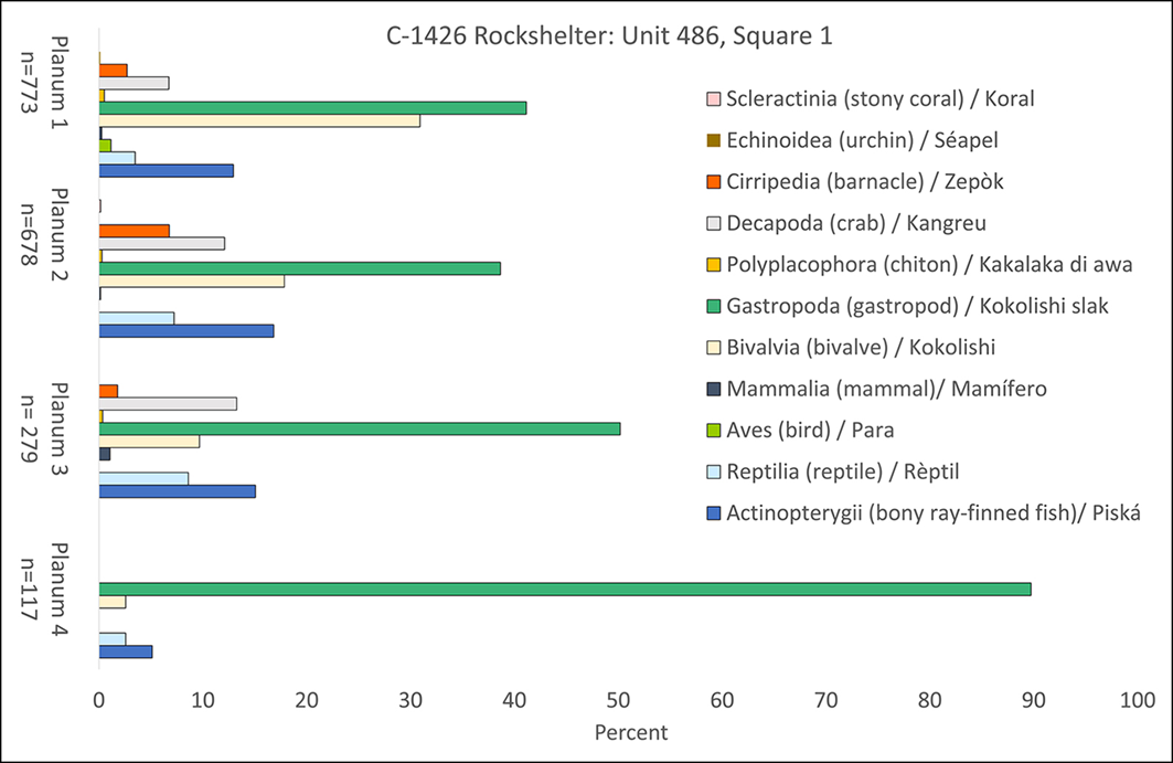
The zooarchaeological assemblage from C-1426 is dominated by marine taxa (Figure 4), consistent with the lack of native large terrestrial animals. Reef fish (e.g. Scarinae, Acanthurus sp.) are common, likely caught on the reef beyond the saliña, 2km away by canoe. One-third (32%) of specimens are marine molluscs, most commonly those found in the saliña, such as oysters (Crassostrea rhizophorae, Isognomon sp.) and West Indian murex (Chicoreus brevifrons). Associated with mangroves and mud flats in protected waters, these taxa suggest that 5500 years ago Saliña Sint Marie was a sheltered, mangrove-fringed bay, as it is today. Ongoing palynological analysis of lagoon sediment cores further supports this interpretation.
Zooarchaeological assemblage from the C-1426 rock shelter (figure by authors).

Colonial plantation, enslaved residential and water-management features co-occur with RSMA’s Indigenous heritage (Figure 3). Lidar imaging and archival records identified these features at the Rif Sint Marie Plantation, established around 1680 (Kraan & Rancuret Reference Kraan and Rancuret2023). Here, survey at part of an enslaved village and artificial reservoir, and excavation of a storehouse and corral, yielded glassware, sheep/goat and pig bones, Ford Model T parts, and ceramics (domestic wares, tobacco pipes and bricks of seventeenth- to nineteenth-century Dutch, English and German origin). These materials reflect the importance of imported goods, introduced livestock and participation in a globalising economy into the twentieth century. Today, RSMA comprises a Ramsar wetland site and national park; plantation buildings are pending protected monuments status.
Jan Thiel Lagoon (JTHI)
Contemporary Jan Thiel is a conservation and recreation area enveloped by residential communities. Designated an Important Bird Area, JTHI’s hypersaline lagoon, salt flats and scrubland provide critical habitat for birds and other wildlife (Debrot & Wells Reference Debrot, Wells, Wege and Anadon-Irizarry2008). Here, CCLP investigation has focused on assessing the nature and spatio-temporal dynamics of human activities. Excavation invalidated one suspected pre-contact site (Den Dunki/Sorsaka) and confirmed five Indigenous period shell middens. Shallow, localised deposits and the lack of artefacts suggest these middens accumulated through intermittent shellfish harvesting (primarily C. rhizophorae, Ctenoides scaber and C. brevifrons) (Figure 5). Dating the shell midden is challenging due to the lagoon’s carbonate geology, highlighting a need for alternative chronological approaches.
JTHI: stone- and earth-walled salt ponds in satellite (A, GoogleEarth) and landscape (B) view; C) shell midden surface, Unit 8; D) bottles of household cleaner (left) and German-made Odol tooth powder (right) from a twentieth-century midden (figure by authors).

JTHI’s salt flats retain remnants of colonial evaporation ponds, walls and dams engineered to manage water salinity for commercial salt production (Debrot & Wells Reference Debrot, Wells, Wege and Anadon-Irizarry2008; Kraan & Rancuret Reference Kraan and Rancuret2023) (Figure 5). Through their effect on freshwater retention, these historical structures are thought to enhance JTHI’s suitability for certain waterbirds (Debrot & de Freitas Reference Debrot and de Freitas1999). Results from sediment core analysis will establish how Indigenous and colonial activities affected lagoon conditions and JTHI’s biodiversity.
Pedestrian survey demonstrated evolving cultural relationships with this landscape. Contemporary hiking and cycling paths, for instance, intersect archaeological heritage. The latter includes an early-twentieth-century midden (approximately 1500m2), rich in foreign-produced consumer goods (Figure 5), that highlights the displacement of JTHI’s colonial-era agroindustry by residential development.
Concluding discussion
Investigations at JTHI and RSMA established nine sites spanning nearly six millennia of Curaçaoan occupation. These findings place Curaçao among the earliest-settled islands in the Caribbean (Keegan & Hofman Reference Keegan and Hofman2017; Napolitano et al. Reference Napolitano2019; Kraan et al. Reference Kraan2024) and provide a rare long-term perspective on human adaptation on arid islands, complementing better-studied humid contexts. Long-term (re)use of C-1426 supports emerging evidence for greater sedentism among early Caribbean peoples than once believed (Chinique de Armas et al. Reference Chinique de Armas2025).
Site types and persistence reveal diverse, enduring use, strategic adaptations and engineering of the landscape to support human enterprises (e.g. site selection for viewsheds, shade, water management features). Salt may have been a key environmental attractant, especially during the colonial period, when it became a valuable export commodity (Antczak Reference Antczak2019). Colonial links to wider commercial networks are evidenced in the foreign-produced materials from seventeenth- to twentieth-century sites. As on other Caribbean islands, these networks facilitated livestock introductions, with resulting biodiversity change captured in Curaçaoan plantation zooarchaeological assemblages.
Taken together, the cultural landscapes of RSMA and JTHI illustrate how millennia of Indigenous and colonial land use have co-produced present-day ecological and heritage values, underscoring the importance of historical ecology for conservation planning on Caribbean islands. By providing historical ecological records relevant to conservation-targeted landscapes, research such as ours advances meaningful heritage and biodiversity management for local communities.
Acknowledgements
We thank Dimitri Cloose, the National Archaeological-Anthropological Memory Management team, volunteers, Simon Fraser University field school students, the Archaeological Working Group Curaçao, Tom Voogd (Coral Estate Luxury Resort), Jorrit Heekelaar, Erik Houtepen (Caribbean Research and Management of Biodiversity Foundation) and Tycho Hombergen.
Funding statement
Social Sciences and Humanities Research Council Canada (IG#435-2024-0910, IDG#430-2020-00177); National Geographic Society (NGS-75166R-21); Max Planck Society; University of Queensland Research Support Package, Anthropocene Project; Simon Fraser University Faculty of Environment Spark grant.
Data availability
Project data are archived in the InTerris Registries database of the National Archaeological-Anthropological Memory Management.




 Open access

