Introduction
Since 2022, archaeological survey has been carried out in Mardin Province, south-east Turkey, in search of caves and rock shelters with Pleistocene and Early Holocene period remains. It is being undertaken by a combined team from Mardin, Ankara, and Oxford University. Research on the Palaeolithic in Turkey is mostly carried out through surveys and, in Eastern Anatolia, in connection with dam constructions (Taşkıran Reference Taşkiran2008; Dinçer Reference Dinçer, Harvati and Roksandic2016). Sites from this period are notoriously rare, difficult to date, and mostly found in open-air contexts, except for the Yarımburgaz Cave, located within Istanbul Province, and Karain Cave, located north-west of Antalya—both Pleistocene sites. Until now, no Palaeolithic site has been securely dated east of Kaletepe Deresi 3 (in Central Anatolia) and in Northern Mesopotamia between El Kown in Central Syria and Shanidar in Iraqi Kurdistan. The cultural and chronological characteristics of the Palaeolithic in this region and their possible interactions with surrounding areas are therefore not known (Bar-Yosef & Belfer-Cohen Reference Bar-Yosef and Belfer-Cohen2001; Muhesen Reference Muhesen2012; Kodaş Reference Kodaş2020; Matthews & Nashli Reference Matthews and Nashli2022). The recording of Şıkefta Elobrahimo Cave during the first season of our survey (Figure 1, nos 1–2), with preserved archaeological layers exhibiting clear signs of hominin occupation, therefore enhances the significance of this region.
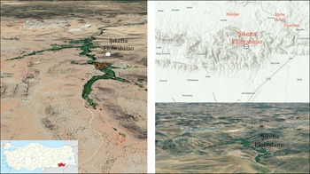
General view of Şıkefta Elobrahimo Cave (1–2), chipped stone products on the cave floor (3–4) (figures by E. Kodaş).

Şıkefta Elobrahimo Cave: location and general description
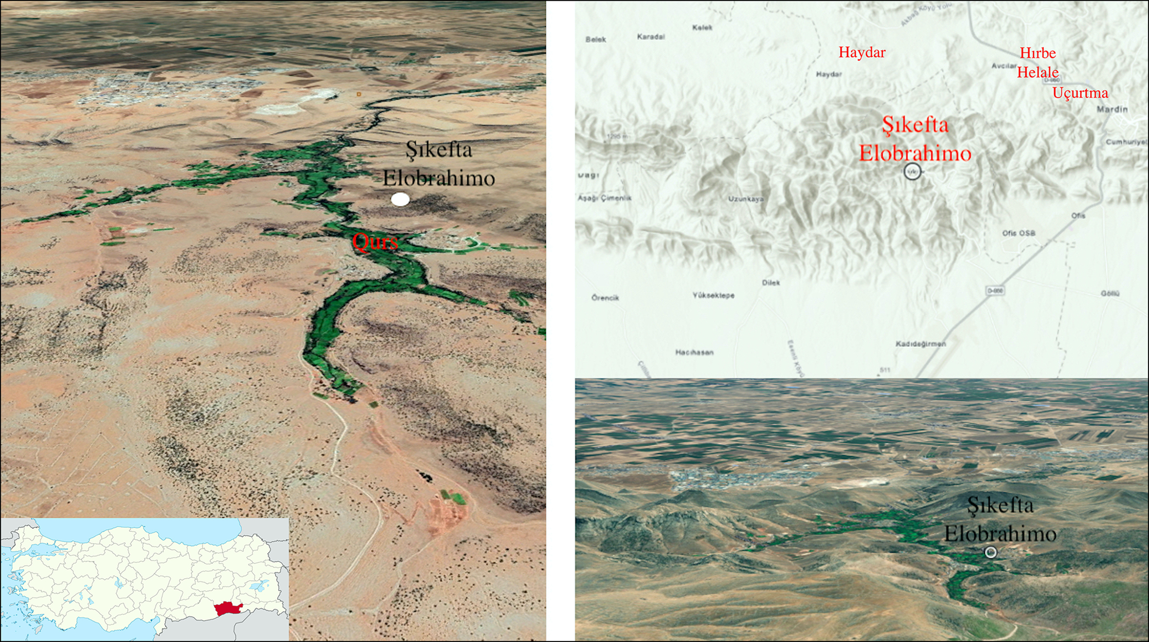
Şıkefta Elobrahimo Cave is located in the territory of Uluköy village in the Ğurs Valley, approximately 5km east of Mardin Airport, in Mardin Province (Figure 2). It was found through the systematic survey of the high-altitude parts of the Kızıltepe district. We recorded each cave and rock shelter based on a preliminary reconnaissance from maps, the systematic exploration of tracks in a vehicle, and the intensive on-foot collection of lithic tools. The Ğurs Valley runs from the plain of Kızıltepe to the Mazı Mountain range, starting at the 600m isohyet, and is deeply cut by the Zergan River, which joins the Khabur River north of the Djebel al-Aziz Range in northern Syria. It is described primarily as a Cretaceous–Palaeocene formation (Karadoğan & Coşkunsu Reference Karadoğan, Coşkunsu, Korkmaz and Karataş2013). A detailed study of the geological context of the cave will be undertaken ahead of archaeological excavation by the geologist from our team, combined with photogrammetric studies.
Localisation of Şıkefta Elobrahimo Cave (figure by E. Kodaş).
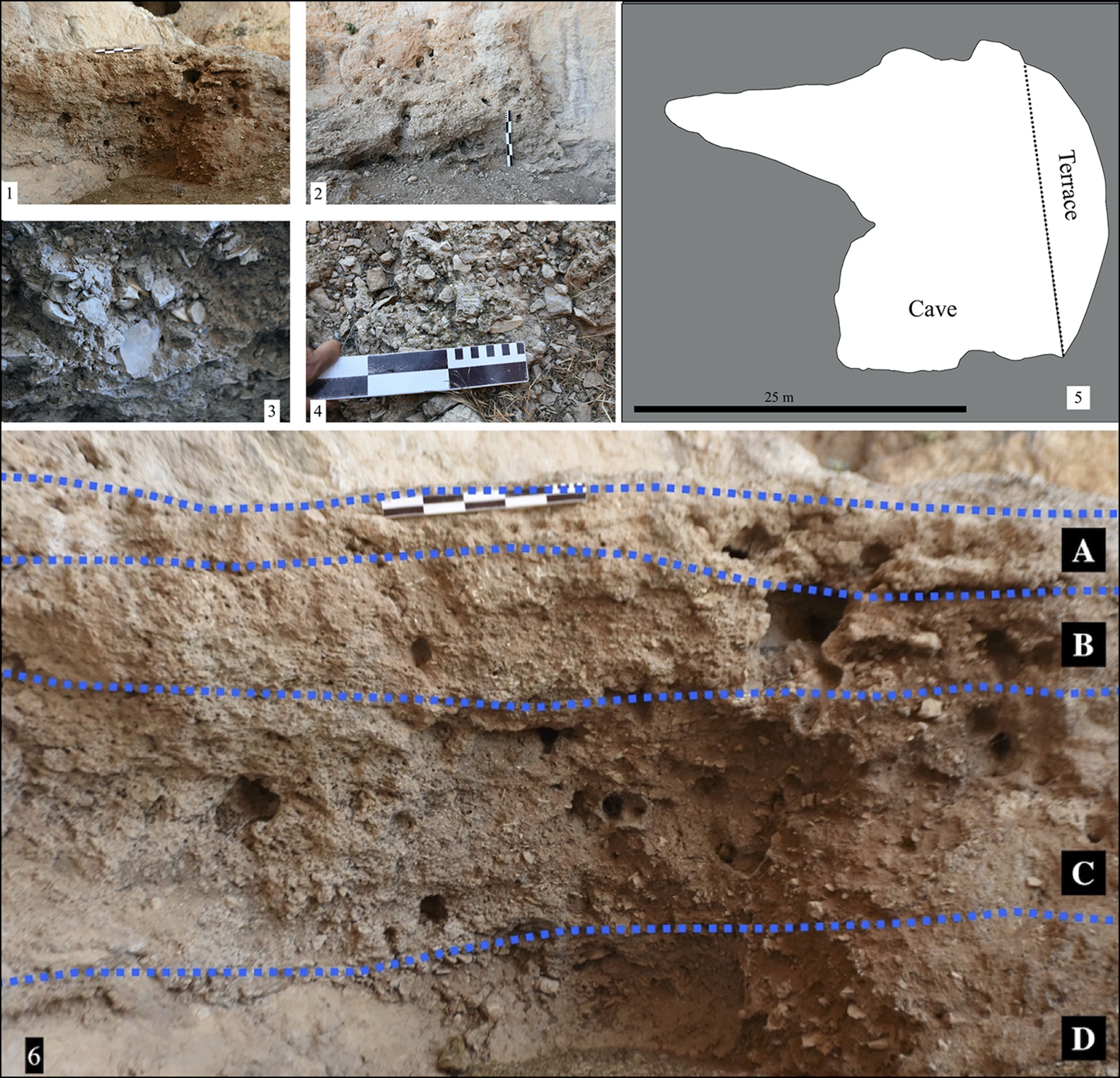
Şıkefta Elobrahimo Cave is situated on the west bank of Ğurs Creek and overlooks the valley. The entrance of the cave faces north-east. It seems to have collapsed, and the floor has now expanded on the slope outside of the cave (Figure 1, nos 3–4). This is hinted at by the rock formation characteristics and the presence of chipped stone tools and bone fragments. In its preserved state, the mouth of the cave is 23.5m wide and 10m high. The cave shows two separate spatial units: an eastern and a western compartment (Figure 3, no. 5). The western compartment has a depth of approximately 23.5m, with its width varying between 7.5 and 2m. Very few finds were noted there. The eastern compartment has a width varying between about 16m and 6m and a depth of 15m. Dense and rich deposits with a clear stratification were observed in this area as well as on the terrace in front of the cave (Figure 3, nos 1–4). Due to illegal excavations into the archaeological deposits, which are in places at least 1.6m deep, parts of a profile section are exposed. They display a high density of animal bones, charred organic remains, and chipped stone. In addition, recent depredations have caused the breaking of blocks of calcinated and petrified deposits containing archaeological material. Those blocks were used to build a wall in front of the cave (Figure 4, no. 2).
Profiles exposed in Şıkefta Elobrahimo Cave (1–2), chipped stones seen on the surface (3–4), plan of the cave (5) (figures by E. Kodaş).
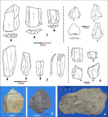
Chipped stone tools—Mousterian—bone fragments and chipped stone in blocks collected in front of the Şıkefta Elobrahimo Cave (figure by E. Kodaş).

Artefacts
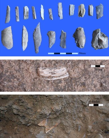
The site has yielded a high density of finds. There are between 50 and 100 chipped stone pieces per square metre in the entire cave area surveyed. However, to avoid disturbing the archaeological context before the upcoming dig, we restricted our investigation to the collection of a limited number of artefacts. We collected 309 stone fragments, among which 223 are debitage and 86 are stone tools (Figure 4, nos 1 & 3–6). Among the chipped stone tools, the Mousterian industry, dating from the Middle Palaeolithic period, is prominent (Otte et al. Reference Otte1998). Thirty-five blades and seven microblades may date from the Upper Palaeolithic based on comparison with assemblages from Karain cave (Özçelik Reference Özçelik2011). Three Levallois preferential flakes and 22 Levallois recurrent flakes, along with two core fragments that could be associated with the Middle or Lower Palaeolithic periods in Anatolia (Dinçer Reference Dinçer, Harvati and Roksandic2016), have also been identified. Two carinated end-scrapers and two side scrapers were also retrieved but cannot be dated. The entire lithic collection is made of flint, which might stem from various sources based on its variation in colour from grey, beige, brown, and reddish to white. Also worth mentioning is a large number of animal bones visible both in the cave profiles and scattered on the floor (Figure 5). There is great potential here to reveal significant data on fauna, flora, and possibly hominin fossil remains.
Bone fragments collected in Şıkefta Elobrahimo Cave and photographed in the field (figure by E. Kodaş).

Overview: perspective
Artefacts retrieved during the first season of our archaeological survey at Şıkefta Elobrahimo Cave point to a Pleistocene occupation. It is difficult to be more precise based on typo-chronological comparisons of stone stools. We will pursue the study of the cave with an excavation, which has already been sanctioned by the Turkish Ministry of Culture and should take place in late 2023. The presence of well-stratified archaeological deposits inside a cave provides us with the opportunity to study preserved materials and contexts that can be securely dated.
Along with the geological study of the environment of the cave, palaeomagnetic dating and biochronology will be used to enhance our understanding of the data retrieved. Our aim is to gather new information regarding hominin groups in south-eastern Anatolia (Homo erectus, neanderthalensis or sapiens), which was one of the dispersal corridors used by hominins. The charred botanical and faunal materials to be sampled in the cave may also provide valuable data regarding the diet and subsistence of the inhabitants. Additionally, we have established the location of other Palaeolithic sites in Mardin Province. The open-air campsite of Haydar is situated 4.5km north-west of Şıkefta Elobrahimo Cave. It is characterised by a heavily Acheulean industry, with 30 biface tools and 47 bifacial tools. Another is Hırbe Helale, located about 4km north of Şıkefta Elobrahimo Cave, where we found more than 2000 biface tools (Kodaş Reference Kodaş2020). It is becoming clear that, starting from the Middle Palaeolithic period and possibly earlier, hominin groups were not only passing through this area but occupying it quite intensively. With the excavation of Şıkefta Elobrahimo Cave and further survey investigations, we hope to better understand movement patterns between the mountainous region of the Upper Khabur and the lowlands and foster knowledge of hominin expansion in the Upper Mesopotamian context.
Funding statement
This research received no specific grant from any funding agency, or from commercial and not-for-profit sectors.