

Introduction
Encroachments by one party onto the land of another may take both legal or illegal – licit or illicit – forms. Assarts may be considered to have been legally sanctioned enclosures, purprestures to have occurred without licence (Griffin, Reference Griffin2018, 276). However, such tidy definitions hide arrangements that were frequently more fluid. With the passage of time or through local custom, perceptions of what was licit or illicit often lost such precise qualities. But, it is within those grey areas of land acquisition that it may be possible to discern patterns of change in the social understanding of land entitlement. ‘Encroachment’ is used here as a catch-all term for exploring the development of these changing patterns of land appropriation, how they occurred and what impact those changes had on the wider body of society. The ‘Lord’s Waste’ is a similarly slippery concept, and societal perceptions of its customary legal identity also changed between 1400 and 1800. These arenas of varying perceptions provide nebulous areas onto which might be mapped the development of social consciousness.
During the early part of the period under discussion, encroachment onto the waste was generally seen as a simple extension of the ever-changing patterns of agricultural land use. During the mid-term climatic deterioration, expanding trade patterns and political change saw the expansion of arable and enclosed lands across the region. The working space between the infields and waste was squeezed. By the 18th century, a cash economy was overtaking customary transactions and land was increasingly perceived as a commodity. This altered concept of the value of land appears to have led to it becoming more jealously guarded. Encroachment upon this asset was deemed illicit and the perpetrators increasingly vilified.
Many wastes in the North-east took the form of a ‘commonty’. Commonties were used by a range of people who had certain rights to the resources of that land, such as grazing, cutting fuel, etc. Some commonties had a single landholder, and the commonty was shared by his or her tenants/smallholders from one or more farming units – fermtouns or single farmsteads. Other commonties comprised undivided land held in common by two or more landholders whose tenants/smallholders had rights of access to the resources (Winchester, Reference Winchester2022, 276). Clearly, this latter situation could fuel disagreements between those using the resources and between the landholders themselves – the notion of ‘Good Neighbourhood’ being the only real defence against such disagreements (Taylor, Reference Taylor2016, 71).
Within the North-east, a large number of commonties occur on former tracts of royal forest. The legal process of disafforestation – found widely across England – is not well recorded for the north-east of Scotland. Royal forests were, in most instances, disbursed by the king amongst his political supporters by grants of free forest, thereby maintaining a closely related type of overlordship to what had formerly existed. (In contrast to such grants, feudal tenure persisted widely across Scotland till 1974, resulting in a myriad of tiny feu-duties, still liable before that date, to feudal superiors.) A complicating factor may be the terminology, as the grants often include ‘lands’ granted in free forest. The aim probably was to stress the absolute nature of the grant, retaining nothing to the king. In other words, land that was not strictly royal forest may have begun to be termed forest after the grant. The Forest of Corrennie may have been just such a case. No mention of a royal forest seems to occur until the forest appears in the hands of the Earl of Huntly in 1575 (ASC 1, 285) – unless it was a pendicle of another royal forest. As these parcels of forest were subdivided and re-allocated (through sale, marriage etc.), the un-enclosed portions not liable to rent were largely ignored, with respect to legalistic itemisation. Only when they began to be seen as economically useful did they begin to cause a problem. The Division of Commonties Act 1695 gave heritors the right to claim and divide the commonties between themselves, provided they could reach agreement. In the case of Bennachie, this agreement was not reached till 1857.
During the 19th century, the North-east of Scotland, in company with many other parts of Britain, appears to have experienced a veritable explosion of squatters moving onto marginal lands (Winchester, Reference Winchester2022, 116). The Colony on Bennachie (Oliver et al., Reference Oliver, Armstrong, Milek, Schofield, Vergunst, Brochard, Gould and Noble2016) is one famous informal example, but other intrusions occurred across many upland and lowland wastes. Was this a new occurrence associated with ‘improved’ agriculture and its expansion into former uncultivated lands? Or, was it largely a better-recorded episode in a long period of agricultural expansion and contraction that occurred over several centuries? Many parts of Britain witnessed encroachments onto lordly wastes from at least the 14th century, as witnessed by extant court records. See, for example, the 14th-century first instances of enclosing the commons cited in the Wakefield Court Rolls (YAS). In many cases, the act of enclosure was considered illicit in either undermining the rights of the commoners or the owner. These offences became increasingly frequent through the later records. However, by the 16th century Wakefield court orders more frequently protected the enclosures against those seeking to remove it and limited access across the former open land on pain of an amercement. In other words, enclosure and exclusion became increasingly common and, finally, became the rule rather than an exception. Such a development marked a distinct diversion from Scots law where a law of trespass was not enacted prior to 1865 when it was used to legally underpin the Highland clearances. (But, see below regarding customary rights of servitude.) In the North-east documentary, records become increasingly visible from the 1400s and, from that time, permit a view of the changing social perceptions of encroachments onto the waste in that area.
Although, in Scottish terms, the North-east is quite well served with documentary and cartographic evidence for the pre-industrialised period, the poorer elements of society that frequently comprised the users of such difficult terrains are usually absent from tacks, rentals, charters, and other land management documents. Fortunately for us – though not for them – these people were sometimes caught and punished, with this happenstance making its way into various of the few court records that survive. On other occasions, the local laird himself may have attempted to engross his holdings at the cost of other users of the land and, again, his action found its way into a judgemental document. Similarly, such an occurrence can occasionally be found within the cartographic record. These sources also contain a much larger selection of possible, lower-status intrusions though, presumably, most of those occurred with the landholders’ knowledge.
Settlement shift, expansion, and contraction through time need to be considered alongside pertinent tenurial arrangements. In a pre-enclosed fermtoun, intown land owed rent, whilst those lands coming in and out of husbandry – such as faughs and other outfields – could not be so readily assessed. But, in a late 18th/19th-century industrialised farm environment, all land was re-organised so as to potentially carry a money rent. Conversely, on a pre-industrialised fermtoun in the North-east, duties owed could take the form of money, crops, livestock, or service – often a mix of all of them (Shepherd, Reference Shepherd2021, 123–141).
References to cottars and their outsets need to be considered in this regard. A cottar received his or her cottage and strips in the open field in return for service. A grassman or woman would receive cottage and grass allotments in return for service. Such dwellings may be represented as the ‘cotts’ noted lying beyond the infields on some estate plans, although some might represent sheepcotes, as shown on the Hill of Mormond on the Strichen estate plans (RHP 30859–38085). In other words, the ‘bigging’ (building) of a cottar’s house in the waste may have been a fairly regular occurrence, prior to the new industrialised farm order. Provided, of course, it lay within the heritor’s recognised land holding and didn’t encroach onto undivided commonty. Examples of the latter are more readily found in the documentary record as such encroachments could result in legal action. A benign bigging on the laird’s waste would have received no mention, but may be recognisable on an estate plan. But, estate plans also record areas of former open fields that subsequently reverted to waste. Scattered ruined farmsteads also attest to the ebb and flow of agricultural use of these zones prior to the late 18th century. Furthermore, in the North-east, a tradition of shieling management – seasonal use of certain lands – adds a further dimension to the difficulty of recognising encroachments.
The evidence is, therefore, complicated and expansion of agriculture frequently can be seen to have been non-linear. This paper will attempt to unravel some of these complications from the surviving dataset whilst realising that such truncated sources can never portray the true complexity of such agricultural and ecological fluctuations.
The first part of the paper will consider the demographic and topographic contexts for encroachment in the North-east. Secondly, the paper will consider the surviving documentary evidence for a range of types of ‘encroachments’ contained in charters and legal disputes prior to 1800. The third part will review the 18th-century cartographic evidence for possible further evidence of encroachments. The evidence will be assessed in order to try to answer the questions: what social and economic drivers resulted in encroachments? What were the social and landscape contexts for these encroachments and who were responsible for such actions? How did the causal factors and participants change through time?
The topographic and demographic context for north-east encroachment
As noted in the introduction, the topography of the north-east is a mix of uplands and lowlands with a history of extensive royal forests and a culture well-attuned to transhumance and seasonal decampments. Compared to southern Britain, it had always had a low, thinly spread population, especially before the increased agglomerations and conurbations of the 19th century. There are certain aspects of English enclosure that resonate with north-eastern encroachments, but these are more broadly reflected in the later period after the Scottish parliament’s Division of the Commonties Act that pre-empted the later 18th- and 19th-century Inclosure Acts of the British parliament. In fact, enclosure protest, as described across England from at least the 13th centuries (Dyer, Reference Dyer2006; McDonagh & Daniels, Reference McDonagh and Daniels2012; McDonagh, Reference McDonagh2019), is rarely, if ever, encountered in the North-east before the 1850s. The alignment of cross-class associations of interest, discussed by McDonagh with respect to the South Cave dispute in Yorkshire during the 16th century (2013), does, however, find resonance with north-east examples where lairds and their tenants faced-off against each other in legal (and more practical) arguments. Also, in contrast to England, lairds in Scotland, in the early 1600s, received greater rights of property ownership in restricting customary rights through the Court of Session than were permitted to their English counterparts (Goodare, Reference Goodare and Whittle2013).
As will be seen, prior to the 18th century north-east encroachments were often more akin to purprestures than legally sanctioned enclosures. Land was generally ‘rived in’ from formerly uncultivated lands and not necessarily enclosed, remaining as outfields. Within an agricultural culture utilising convertible husbandry (Rippon, Reference Rippon2014, 135) – or infield/outfield agriculture, in Scottish speech (Anderson, Reference Anderson1794, 54–5) – temporary enclosure was an ongoing process. Sometimes these enclosures became permanent, sometimes permanent for an indeterminate period before, once more, becoming temporary and, sometimes, returning once more to waste. And then, the cycle may have begun again. To complicate matters still further, parts of the region utilised shielings for temporary seasonal pasturing. These could be many miles distant or virtually adjoining (see Bil, Reference Bil1990). Field and place-name evidence suggests that these also might become permanent prior to returning to seasonal usage, whilst others became permanent and stayed that way. One documented case indicating this ebb and flow of agriculture occurred in 1459 on the lands of Cauty (see Figure 1). In evidence to the court, it was recalled by a witness that the Bailie of the time Philip of Dunbrek ‘passit to the said land and straik the [low]mys in twa and hewyt the plwche. Than eftyr that the land lay lang onoccupyt. Quhilk interruptioun maid be the said bailye is weill knawyn tyl divers of yowr lordschypis and als tyll mony of the eldayst mene in the cuntrey’. (Illus AB, 3, 62).
Study area showing places referred to in the text and major towns. Original spellings retained. Grey zone depicts simplified upland zone based upon land capability for agriculture and topography.

The period between 1400 and the 18th-century therefore – differentially depending upon local custom and landownership – saw a dramatic change in how land and, for the purposes of this paper, waste land in particular, was managed. For the first hundred years of the period the waste, if not freely available to all, was widely treated in that fashion. By the 1800s, the waste had become a jealously guarded resource of the landowner. But, between the waste and the intown lands lay a band of outfield land that was in a constant state of flux (Winchester, Reference Winchester2022, 14–5). In this way, the situation probably differs most to lowland England, where that agro-ecological band was often merely a thin ribbon or less. Only in the extreme north, west and in Wales, might areas of comparable management issues be expected. In the North-east, during the study period, that formerly wide, intermediate zone narrowed as land management increasingly prioritised arable over pastoral regimes and then later, in some zones, diversified into beef (Shepherd, Reference Shepherd2021a; Shepherd, Reference Shepherd2021b). Oram notes how Scotland’s 15th-century legislators were ‘seeking to address the results of poorer growing conditions through instructing landowners and their tenants simply to plant and grow higher volumes of grain crops or increase their livestock numbers’ in order to combat the deteriorating climatic conditions (Reference Oram, Dixon and Theune2021, 28). The 15th and 16th centuries, furthermore, saw the eradication of great swathes of former forest lands in the face of such advancing agriculture. The 1506 royal grant to the Earl of Huntly permitting the cultivation of the former vast royal forests of Enzie and Boyne, lying along the Moray coast, is a fine example (RRS, Vol. 2, 2958, p.628).
Legalistically and, by association tenurially, changes militated against the defence of common rights to the waste, with the Court of Session increasingly restricting former customary usages in the early 17th century (Goodare, Reference Goodare and Whittle2013) with rights of servitude by tenants increasingly unprotected (Winchester, Reference Winchester2022, 136). Such changes may be considered resultant upon the development of capitalised agrarianism throughout this period but, as is frequently the case in the North-east, the evidence suggests that the trajectory was non-linear and sporadic (Shepherd, Reference Shepherd2015). Alongside these trends, most clearly visible with respect to the management of the more intensively cropped infields and outfields needs to be factored the more rarified evidence concerning the waste, which is the focus of this present paper.
Although wealthy to a point that might be difficult to imagine today, during the 13th century, Aberdeenshire, basked in the profits of a lucrative wool trade (Campbell, Reference Campbell2008; Shepherd, Reference Shepherd2021c). Dyer notes that, in Gloucestershire, half of the wool supplied came from peasant flocks (Reference Dyer and Whittle2013, 31). If the same applied to Aberdeenshire, the wealth recognised by Campbell may well have been spread around fairly equitably. Even so, this did not translate into a population that struggled for space, as appears to have been the case in certain parts of the English midlands. See, for example, the field coverage in Northamptonshire that left little room for expansion (Partida et al., Reference Partida, Hall and Foard2013). In other words, encroachments were driven by a slightly different set of circumstances than affected the champion districts of England. Parallels may more profitably be drawn with other topographically and demographically similar parts of Britain, such as Wales and the extreme south-west of England.
Certain parallels for the later period may, however, exist. On Booker Common, Buckinghamshire during the 17th and 18th centuries, many encroachments were made by smallholders building and occupying houses. The manorial court amerced them but permitted them to remain. The ‘amercement’, in effect, was a rent. This was finally tidied up by the court in 1778 when it ruled that as long as enclosures accrued rent, they could remain (Kerner, Reference Kerner2012, 186–87). Similarly, in the case of the New Forest, squatters were not considered harmful, provided they did not cause depredation to the trees (Griffin, Reference Griffin2018, 287). Such perceptions might be born in mind with respect to the north-east of Scotland.
Winchester speaks of a ‘paradox which lies at the heart of common land in Britain’ (Reference Winchester2022, 275). This is that communally used land is defined in terms of private property rights. But, as has been noted in the case of Scotland, this is largely a product of post-mediaeval, centralised appropriation of those customary rights. This paper seeks to tease out the process of how and why such appropriation became communally accepted by considering the evidence for encroachment upon those wastes that had been customarily used by local communities.
During the eighties, Dodgshon (Reference Dodgshon1980a, Reference Dodgshon1980b) and Whyte (Reference Whyte1979, Reference Whyte, Parry and Slater1980, Reference Whyte, Whittington and Whyte1983) both made dramatic inroads looking at the composition of pre-modern fermtouns in Aberdeenshire. Subsequently, Dodgshon considered land management strategies in the Highlands and along the west coast in great detail. However, the east coast is distinctive culturally, climatically, and topographically from those areas and conclusions drawn from the Highlands are rarely directly transferable to the North-east. It might be argued that the development of lowland farming in the North-east had more in common with developments in parts of lowland England than ever it had with the Highlands and Islands. A mid-12th-century grain-drying kiln discovered at Druminnor Castle (Shepherd, Reference Shepherd2018) speaks of a long and technologically advanced mediaeval agricultural regime, ill-fitted to the topography of the Highlands. For the lower-lying north of Scotland, east of the Highland zone, little data concerning encroachments prior to the period of government-sanctioned lairdly enclosure of commonties have so far been collated, with Oram further noting the paucity of environmental data and the need to refer to ‘proxy data’ from remote regions (Reference Oram, Dixon and Theune2021, 27). Shepherd has considered developmental aspects of the north-east farmscape (2021), but encroachments as an individual class have not been widely considered and that work remains under-represented.
Documentary evidence for pre-modern encroachment of the waste
There are many examples of legal cases dating to the 15th century in which the defendants are accused of the ‘occupation and manuring of lands’ and of with-holding the profits. Three disputes, all dating to 1489, involve such actions in the parishes of Keith, Mortlach and Culter (Illus AB, 2, 248; 264; AB Coll, 299). Although called ‘violent occupations’, they were, realistically, merely actions brought against tenants who stayed on for longer than the term of their lease and were being pursued for loss of rent and loss of profit for the heritor had the latter been in possession of the land. In other words, such actions were simply aimed at securing debt and due compensation and had nothing to do with encroachments.
In other instances, however, it is less clear whether the same situation pertained, even when the same language was employed by the pursuers in the case. A 1495 case at Fetternear (REA, 1, 318) accused Thomas Drumbrek and his wife Agnes of labouring and manuring the lands of Fetternear belonging to the bishop and for depriving him of two years rents and profits. The problem is the lands of Fetternear comprised a large, prestigious holding, which was, in 1511, held by 8 tenants and 14 crofters (REA, 1, 365). In the previous three cases, the lands under question were clearly named, whole fermtouns. The Fetternear case reads as if the land in question is of a much smaller scale and the defendants of lower social status. In other words, this case may suggest an opportunist ‘riving in’ of former unused land. However, in this case, after over five hundred years, the jury is still out.
Two cases from Morayshire leave less doubt. The first, in 1519, involved William Balye encroaching upon the lands of Auchquorthies, belonging to the Bishop of Moray. ‘…the new biggit seyt be Wilyam Balye be destrowit and ly waist in tyme to cum and at he had na richt to manur nor appropir the samyn be na way of propirte’. (REM, 391) The passage goes on to outline the bounds dividing the two sets of land, indicating that an encroachment onto the bishop’s land had definitely occurred. Moreover, this was clearly a new ‘set’ and the lands had not been previously laboured. The court specified that the lands were to be returned to pasture and ‘faill casting’ (digging soils for producing a soil/manure mix for dressing arable land).
A similar case affected the debateable lands between Kilravok and Croy (REM, 244). ‘…the houssis that are biggit betwix the kirk and the wod of Croy be castin down – the corn that growis in the grond perteining to the said housis be given to the power (poor) men… … the said landis thareftir togiddir with the girs of the wod lik as it wes riddin to be common pastour…’ New lands were clearly taken out of the common and were to be returned to it. (It is interesting to note the reference to woodland pasture in the case as well as the charitable use of the proceeds.) It also goes on to note that the pasture was to be common to both fermtouns, so the issue was not necessarily simply one of a boundary dispute. The Bishop recognised that his tenants also had no rights to claim the land for purposes of engrossment.
This also seems to have been the major issue at Delgattie in 1539: ‘…has ryven out teilit and sawin cornis upon the samen quhilk war not ryven out of befor/and pasturit thair guidis and cassin fewill upon othir partis tharof within the saidis boundis quhair nay guids war pasturit nor feuil cassin of before’ (Illus AB, 2, 359). The issue was not only the sowing of the corn but also the pasturing and peat digging, which had not previously been carried out. This was clearly an encroachment on the waste, though without the construction of any new buildings. At Maryculter in 1548 occurred the ‘wrangus teling and riving out of ane parte of the saydis Lord of his Manis…’ (Illus AB, 359). The use of the term ‘riving’ suggests that the lands had not formerly been tilled. Permission to rive in new land occurred in 1576 where the proprietor was given leave to ‘teill, fauch and ryive ley and muir’ (ASC 1, 226).
Another type of encroachment occurred prior to 1596 on the lands of the Earl of Errol (Coll AB, 386). The laird of Mouhquhallis had his shepherd build a house and sheep cot on land belonging to the Earl of Errol. The Earl asked of the shepherd to whom did the house and the land belong. The shepherd said that the land was the Earl’s but that the house and cott belonged to the laird of Mouhquahallis. This was recounted by a witness at an inquest as to the correct boundary between the two estates in 1596 as evidence and appears to have been accepted by all. Firstly, it seems to be a very pleasant recollection of a rather civil accommodation by the Earl of Errol. There appears to be no reason to doubt the account and it appears to have been found acceptable to the inquest in 1596. It does, therefore, suggest that between assenting heritors one person’s house might be built on neighbouring land, provided that it was always remembered to whom the land belonged. Secondly, it suggests that, in the North-east, property and possession did not necessarily give long-term tenurial rights over land. However, this case resonates with a dispute between Lord Forbes and the Bishop of Aberdeen over a piece of land on the Correen Hills (Lurgyndaspok) that finally reached a compromise in 1391 (REA, 1, 248–49; 176–77). During the spat, the bishop claimed, as evidence for the diocese’s claim to the ground, that their tenant, Sir John Broun, had formerly kept his sheepcotes and shepherd’s houses there. Perhaps the Earl of Errol was being too trusting.
As the 17th century progressed, the Aberdeenshire Sheriff Court was increasingly called upon to consider cases of encroachment onto commonties. Two reasons probably help to explain this. Firstly, the population by that time had recovered from the Black Death and needed room and food for further expansion. Secondly, and in association, increasing amounts of land were being given over to the production of grain in the North-east. Close economic ties with the Baltic resulted in increased timber imports and a comparable export of grain. The denuding of the region’s woods during the course of the 15th and 16th centuries further encouraged that two-way trade (Shepherd, Reference Shepherd2021, 115–20).
In 1624, Patrick Reid of Cornabo was said to have sown corn on the commonty of Tulloche (ASC 2, 279). In 1608, corn was sown on Mormond Hill, which was still used as commonty until the 19th century. However, in this instance, this may have been a case of one heritor on the north side of the hill, at Forest, attempting to extend his claim across to the south side of the hill, closer to where the defendants lived (ASC 2, 139). A rather curious sounding case was brought against John Forbes of Tillekirie for sowing corn on the ‘Cornefauld and Outsettis of Tilliekirie’ that Patrick Leslie of Kincraigie claimed to be part and pertinent of Kincragie (ASC 2, 93). In the south end of the county in 1609, corn was sown within the bounds of the laird of Culter, the case being brought by Alexr. Irving of Drum against Alexr. Cumming. However, Alexr. Cumming, the following month, brought a counter-claim against Alexr. Irving (ASC 2, 148). In other words, not all of these cases are cut and dried. But, it certainly looks like the 17th century may have seen a move away from a laissez-faire approach to communal living. The Barony of Urie noted, in June 1604, that grazing on other tenants’ headrooms (pasture lands) was no longer to be permitted, indicating that, previously, it had been common practice (SHS 1892, 6).
Outsets and shielings
A complicating factor in attempting to discern ‘encroachments’ is the situation concerning ‘outsets’. These were, obviously, secondary parcels of land ‘outset’ from the parent fermtoun. It is probable that many such outsets were themselves as old as the fermtoun core – part of a dispersed settlement pattern. (Sadly, that fascinating discussion falls outwith the reach of this paper.) For present purposes, only those outsets will be considered that show some indication of having been recent innovations. A good example of this was the Hauche of Bogie. In 1511, Robert Blak was granted leave by the Bishop to build and occupy three outsets on a ploughgate of land (perceived to be about 100 acres and, therefore, allowing approximately 30 acres – a virgate in English money – per outset), provided they had been built by 1512. Failure to complete would invalidate his licence (REA, i 364). In this instance, the licence permitted a licit expansion of arable and buildings onto former unploughed haughland, incidentally suggesting that its former use had been for pasture, meadow, or both. Another possible example of a change of use from arable to the site of a new outset occurred at Clatt in 1558 where a charter records ‘…and for the tenement callit Newbiggyn alias Rudriggis…’ (Illus AB, 4, 491). The names strongly suggest that former rigs had been used for a new bigging site.
More common are references to ‘outset cottages’ as pendicles of the core holding. For example in 1692 at Arnadge, ‘.the other hill parts and pendicles thereof the outsetis cottages of said lands…’ (Illus AB, 3, 23). At Mintlaw in 1607, Thomas Forbes was in court for ‘houssis and yards bigit be him upone the loning (driftway used for travel and pasture) of Myntlaw’. (ASC 2, 104). In 1527 at Dudwick, James Innes was given permission to ‘mak cotaris and underseddillis under him…’ (Illus AB, 3, 49). In other words, he was given the right to create new outsets for new cottars on his land. At the much later date of 1741, the Barony Court of Urie directed that ‘by the late increase of houses, the mosses and grounds within the barrony are in danger of being wasted…. he ordains that no houses be built but what were in old use and wont’ (SHS 1892, 168). Clearly, at that time, there was extensive outsetting onto unlaboured lands. (More evidence exists for such outset cots and cottages on the estate plan evidence, which will be considered in due course.) Another reference to an outset ‘in the moor’ occurs in an 18th-century inventory of building timbers at Memsie (MS 3004/320). This was a sheep house that also included a ‘lumb’ that, in this case, is more likely to indicate a loom than a chimney. But, it does add to the evidence for licit buildings laying in the waste.
Finally, the transformation of outset cottages to intown lands appears to be captured by the Urie court in 1730 (140), ‘That some of these subtacks were antiently the cottar crofts of the toun of Reidcloak (cottages received in return for service) … and afterwards [were paid for] in mony rent, before that ever they were set for farm bear’. This appears to track the development of a former outset cottage to its eventual inclusion into the intown lands. An interesting decree of 1726, giving further evidence of the extension of arable onto former commonty (130), states ‘…no person shall cast turffs or earth whatsoever upon the ground contiguous to his neighbours corns, if his neighbours incline to improve the same for corn ground’. The passage is referring to commonty land, and it is clearly presumed that the neighbour would have the court’s blessing to rive in some of the waste (presumably with increased rent).
As noted above, a related theme concerns shielings. Explicit evidence for shiels becoming permanent outset pendicles is quite rare and, where it exists, is usually only circumstantial place-name evidence rather than anything more legally documented. One pleasing example, however, occurs in the records of the monastery of Kinloss, though relating to their grange lands in Strathisla. Within the 1574 rental is found the ‘Newlands of Millegin, callit Jonettis Scheill’ (Cart. Abb. Kynl., 156). The combination of the ‘new’ element with the, presumably, older ‘scheill’ name strongly suggests a move to permanency. More common are place names using the ‘shiel’ element, which occurs in a range of different spellings. The Gaelic terms for shieling discussed by Bil (Reference Bil1990, 34) are not considered here owing to space. However, the element ‘rie’, contracted from ‘airigh’ and ‘ruighe’ may well be fairly common in north-eastern place names, with untruncated forms found on the Glen Carvie estate plan (MS 2769/1/131/6).
Scheilfield in Leochel was already recorded in 1598 as a permanent pendicle (Illus AB, 4, 355), whilst Old Shield still survives as a small farm on the edge of Teindland Forest (itself an interesting name). This site lay, sadly, just off the edge of an estate plan to be considered in greater detail below. Only the name Burn of Auld Shiel, transcribed on the plan, hints at its existence at that time. However, its altitude and the disposition of known 18th-century fields suggest it to have been a new permanent creation at that time or shortly thereafter. It is depicted as a small farm on the 1st edition OS. (‘Auld’ seems to have been a frequent corruption of Gaelic ‘allt’ – burn.)
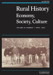
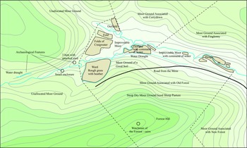
In the Clashindarroch Forest, a fairly recently identified shieling just west of Craigwater appears to be a more concrete example of the transitory development of some upland holdings. The site (Aberdeenshire HER NJ43SW0037; DES, 11 (2010), 23) consists of three small, sub-rectangular huts with an attached yard. The huts are all approximately 6m x 4m externally and, nearby, are a further small enclosure. An 18th-century estate plan of the area (RHP 2266) shows the ‘ward’ and folds of Craigwater as pendicles of Old Forest, but with no farmstead and no shieling huts (see Figure 2). The huts would have been set just beyond the common grazings of Old Forest on the even more common grazings of the wider community beyond that. (Thus underlining the subtle nuances that might define different types of ‘commons’ within a single lordship.) However, the folds had been improved by the use of water draughts (lades) and a further lade survived even further upstream from the huts, suggesting former ‘improvement’ of the folds that lay between the burns at Craigwater. By the time of the 1st edition OS, Craigwater was a small farmstead with adjoining yard but with no associated fields – perhaps a shepherd’s dwelling. Nothing now exists on the site apart from a few earthworks showing the position of the former folds. This small case study shows how a shieling site might be developed as outfield improved folds in the mid-18th century, perhaps rationalised into a shepherding station in the 19th and, thereafter, fell into disuse. Its fate was tied to the perceived usefulness or otherwise of the land at different points in time.
The outset pendicle of Old Forest known as Craigwater, showing archaeological remains of shielings and water draught on redrawn 18th-century plan (RHP 2266).
Numerous shiel place names survive across the area that attest a more permanent development at an earlier period than what occurred at Craigwater. There was a Sheillis in Tillybirlach in 1632 (ASC 2, 361), Scheill in Wrangham in 1633 (ASC 2, 376) and the interesting and substantial fermtoun of Shiels on the eastern side of the former Forest of Corrennie, to name but a few. This forest was referenced as part of the Earl of Huntly’s holdings in 1575 (ASC 1, 285) and seems to be a good example of a royal grant of free forest to a nobleman who then dissipated the entity amongst lesser nobility. Another example of this type of dissipation, again from the hands of the Earls of Huntly, was the Forest of Awne (Enzie) along the Moray coast. As noted above, such distributions appear to have led to the undivided commonties of the area. Other similar stretches of upland were clearly partitioned from an early date. The Correen Hills split between the Forbeses and the bishops of Aberdeen are a good example of divided uplands that were used as commonty by the two estates in severalty – though both parties, as noted, had wrangled about quite where the division should lay.
Cartographic evidence for pre-modern encroachment of the waste
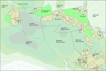
As noted above, cartographic evidence can indicate low-status dwellings that evade the documentary record. For instance, a useful comparison may be made regarding the 1662 charter for Meldrum (MS 2778/1/3) and the estate plans surveyed just over a hundred years later (RHP 11738; RHP 11743). In the former, there are references to ‘lands of Corehill, Borbush commonlie called Baybush’ and no mention of the smaller outsets of Ardevin, Playgreen and Blackbog. All other references in the charter employ the formula ‘the toune and lands of…’, even when the holdings are small pendicles, such as the probable former pasturelands of ‘Blachrie, Easter and Wester Badichelle, Swanfuird and Nether Muirfuindlands’ all in the ‘muirs of Fyvie’. (Note also the possible ‘shiel’ name – Badichelle – and the possible ‘rie’ name – Blachrie.) The estate plans clearly show inhabited holdings at Corehill, Baybush, Playgreen, Blackbog and Ardevin, set within open grazing lands (see Figure 3).
Small outset settlements of Corehill, Ardevin, Baeybush, Blackbog, and Playgreen set amongst upland pasture.

One piece of cartographic evidence demonstrating ‘turf wars’ between adjoining heritors over waste can be seen on a 1769 plan of Mosstowie in Moray (MS 31157) that lay on the east side of a large, upland waste. The written details explain two small rectangles as, ‘A house built by Lord Murray and turned down (by) Lord Fifes Factor’ and ‘A house built by Lord Fifes people and interrupted by Lord Murray’. At Unthank Moss encroachments on the waste were more permanent. An estate plan of Unthank Moss (Roseisle), dated to 1756 (RHP 031) records the moss prior to its enclosure and drainage. One part is coloured red and records the ‘moss yards clemd by Sir Robert’, whilst another separate area records ‘Butts clemd by Sir Robert, incroachments made by Mr Dunbars tenants’. The fact that the second portion is called ‘butts’ indicates it had already been converted to ploughed lands by Mr. Dunbar’s encroaching tenants. However, this ‘fait accompli’ appears to have been magnanimously accepted by Sir Robert in this instance. How long these ‘encroachments’ had been in existence is unknown. The first portion claimed by Sir Robert refers to ‘moss yards’, which may indicate that they were already improved pasturelands on the moss.
Corrennie represents a slightly different progression. In this instance, a former large expanse of upland commonty appears to have been encroached upon from an early period. The plan (RHP 235) was surveyed in 1834 but utilised between 1849 and 1851 in order to confirm the landholders’ agreement as to who held what in 1849 and to define a new, reduced area of commonty, this being further updated in 1851. After this period, the separate landholders provided improving tenancies, presumably in order to increase revenue. Of particular interest for this paper is the recording of these earlier intakes on the former commonty: the reference to herd’s huts, cots and the place-name Shiels on the east side of the hills.
Case study – Inchberry, Speyside
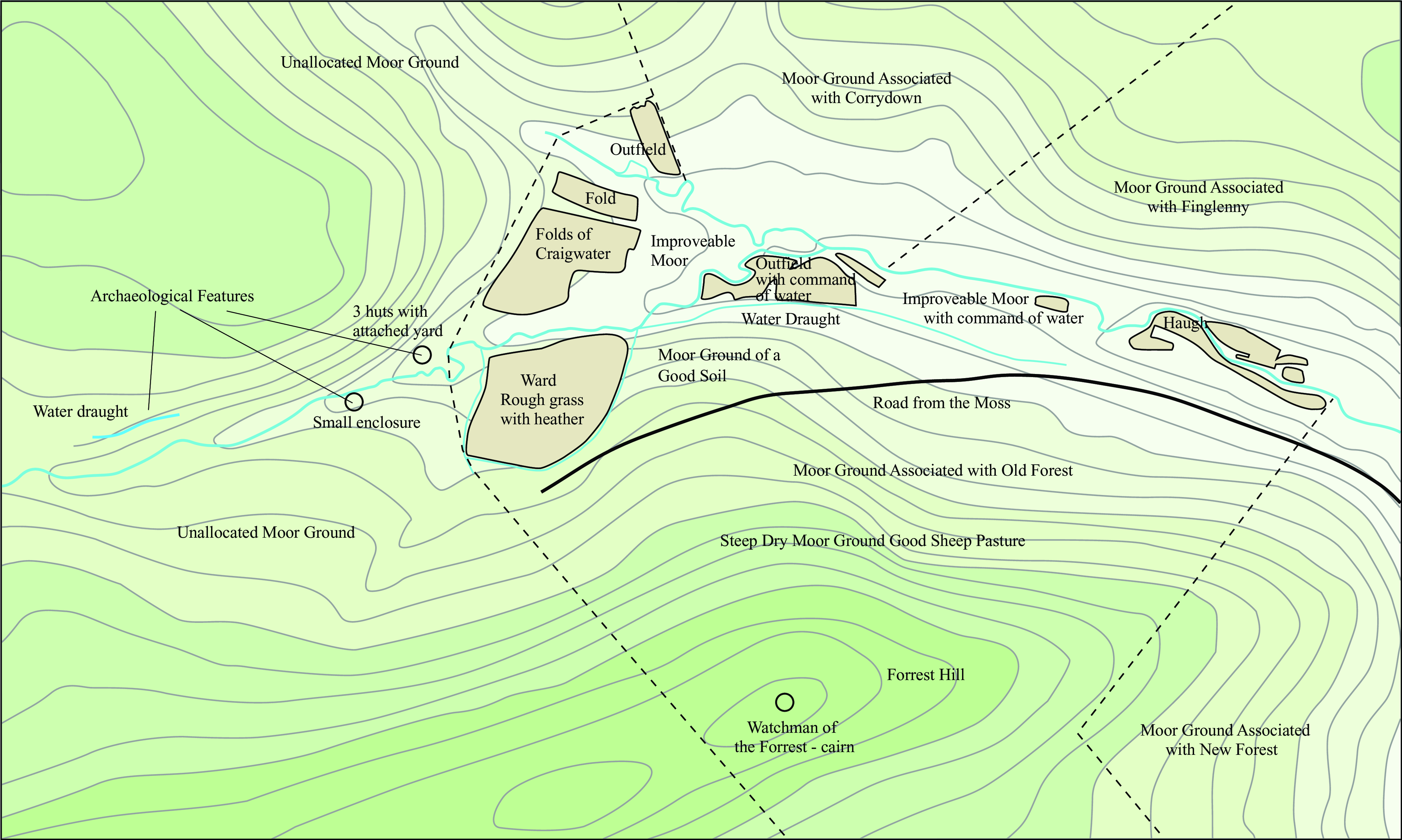
Two estate plans exist that show the Barony of Inchberry on the River Spey. The earliest (RHP 2430) is dated to c.1775, whilst the second (RHP 2426) is dated to 1809 (Figure 4). The 1st edition of the Ordnance Survey plan was surveyed around 1871. The three plans, therefore, demonstrate how the landscape was altered between the mid-18th and the mid-19th centuries at roughly fifty-year intervals (assuming the c.1775 plan to have some chronological depth). To have two estate plans from the one area showing such a step-change is unusual for the north of Scotland. The earlier survey is also enhanced by useful descriptions of new lands that suggest recent intakes. By the time of the OS map, almost all of the floodplain of the Spey had been turned over to arable and other enclosed fields.
Barony of Inchberry c.1871 (top), c.1806 (middle) and c. 1775 (bottom).
The evidence from the plans
The haughlands running beside the Spey and an ‘old run’ of the Spey were virtually unchanged from the first to the second plan (see Figure 5). These will have represented the ‘infield’ during the 18th century. Interestingly, the hamlet of Elly retained its footprint, but the individual buildings all appear to have undergone significant change in the interim. On the earlier plan, fields immediately west of the hamlet were said to have been previously laboured but were, at that time, undrained. By the later plan, this area appears to have been enclosed. However, even on the earlier plan, the area seems to have been enclosed by drainage ditches that, presumably, were not doing their job adequately.
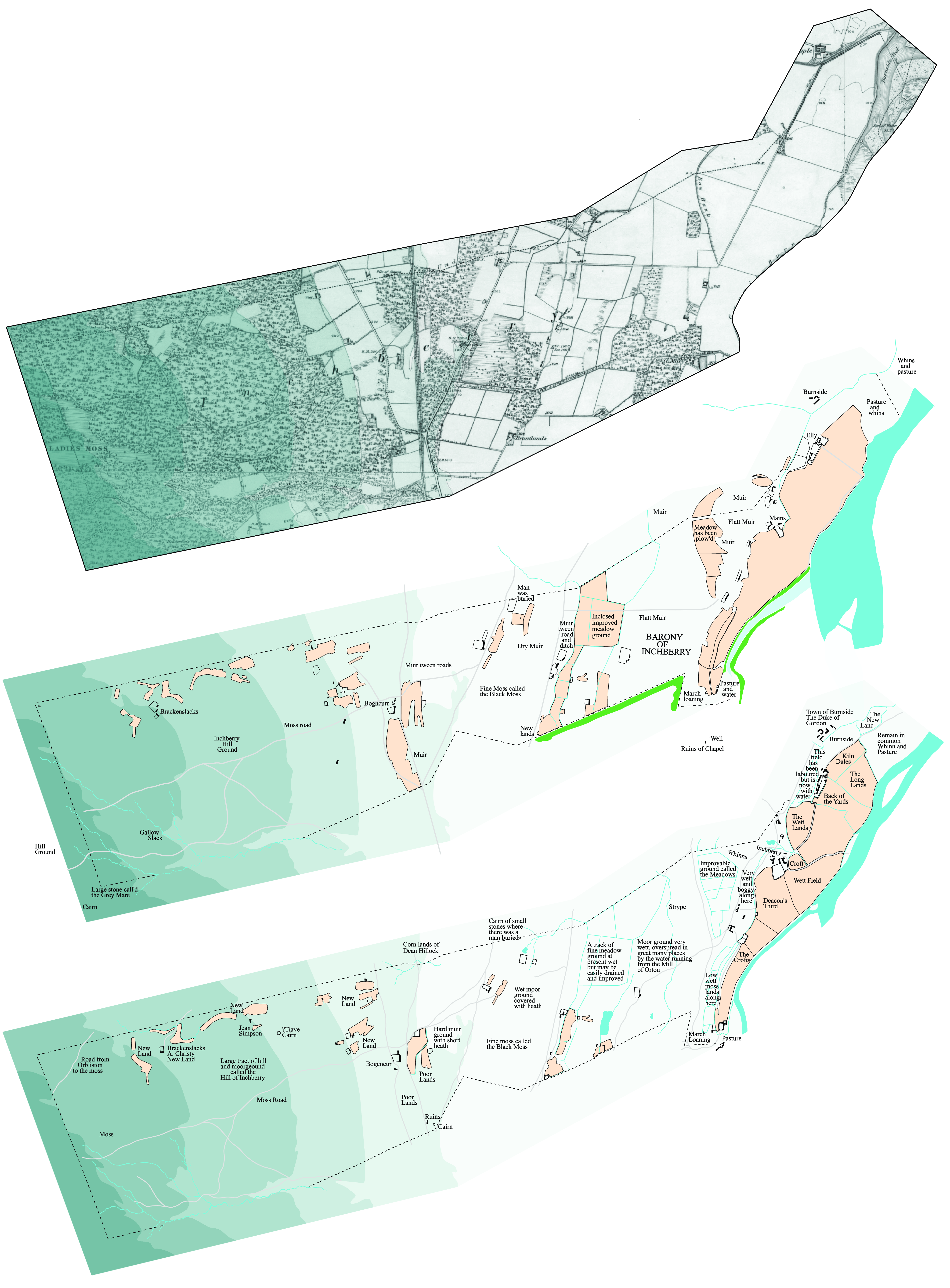
East side of the Barony of Inchberry c.1806 (top) and c.1775 (bottom).
The Mains lay to the south of Elly as a separate unit. Presumably, Elly could be seen as the cot-town wherein stayed the majority of those owing service on the demesne’s infields. Service dues formed a significant part of rentals in the North-east up until the end of the 18th century. On the earlier plan, the Mains is named as Inchberry and one building on the north side of a yard is shown with a rounded end. This may have been a kiln barn associated with the Mains. This small collection of yard and two ranges is also unusual in showing little difference in plan between the two maps. To the north of Elly lay a field known as Kiln Dales, suggesting a drying kiln in the vicinity at some earlier time. Other field names indicate the general wetness of these low-lying lands and a particularly intriguing names – Deacon’s Third – suggests an ecclesiastical portion or endowment.
One of the most interesting features of the two plans is the amount of drainage that appears on the first plan alongside written evidence of its use as meadow and pastureland. In other words, the land was drained by an extensive array of drainage ditches, but their conversion to arable land only occurred during the interim period prior to the second survey or, generally, later even than that. A large area of drained land ‘called the Meadows’, lying west of Deacon’s Third, was marked as improvable. This may suggest that part of the reason for the first survey was to design a fieldscape privileging arable over former pasture. On the second plan, part of this particular meadow was noted as having been previously ploughed. Whether this was prior to the first plan or had occurred in the interim is not known. However, arable had still not superseded meadow in these areas. Even on the later plan, it was still termed meadow.
Between the infields and these meadows were two sets of buildings and yards, presumably representing two small rentier units. As at Elly and the Mains, their buildings appear different on the two plans, though they occupied similar locations. One lonesome building shown in the earlier plan had been incorporated into a double yard by the time of the second plan. To the west of these buildings and their possibly associated meadows, lay the wet moor ground that was frequently watered by the overspill from the neighbour’s mill at Orton, which must have been very annoying.
Beyond this moorground lay another series of farm units and associated meadowland. Again, these areas had been largely drained by the time of the first plan with the farm buildings having been more fully developed by the time of the second. One area of water had been completely drained and turned into a field. The small building associated with this area appears to have doubled in size and had added an extra yard by the time of the second plan. East of this, a small unit latterly consisted of two extra buildings and a much larger yard. In other words, there appears to have been a general increase in affluence during this period in which small farmers appear to have been investing in their farms, even though these could only have been held on leases. It may suggest a belief in security of tenure, the lack of which was generally criticised by writers of the Old Statistical Accounts at the end of the 18th century. Otherwise, the improvements would have to have been instigated by the heritor, which, in this case, appears unlikely. Such piecemeal development looks more like the work of individuals. The same might be said of developments further up the hill, which will be discussed in due course.
West of these improved meadows a new road was laid out – or, it seems that way in consideration of its straightness. Thereafter lay muir ground that was described as wet on the first plan and dry on the second. But, the surveyors both agreed that to the south of this lay a ‘Fine moss called the Black Moss’. Presumably, this supplied fuel for many of the indwellers of the Barony. The two farm units in this area also showed considerable development between the two plans. And, on the northern boundary, was a cairn of small stones marking the spot where a man was believed to have been buried. Presumably, he had done something wrong that exempted him from holy ground and forced his burial on a boundary.
West of these features (see Figure 6) lay another north-south route that also shows signs of recent remodelling and beyond that, at Bogencurr, lay a third north-south through route. This one, however, shows less signs of updating. The place name, Bogencurr, also contains seemingly ancient Gaelic/Pictish elements. The three routes noted diverge from each other on the southern boundary where the first plan indicates a cairn to have stood. It also notes a ruined building at this point, indicating that, alongside developments, older elements were falling into disuse.
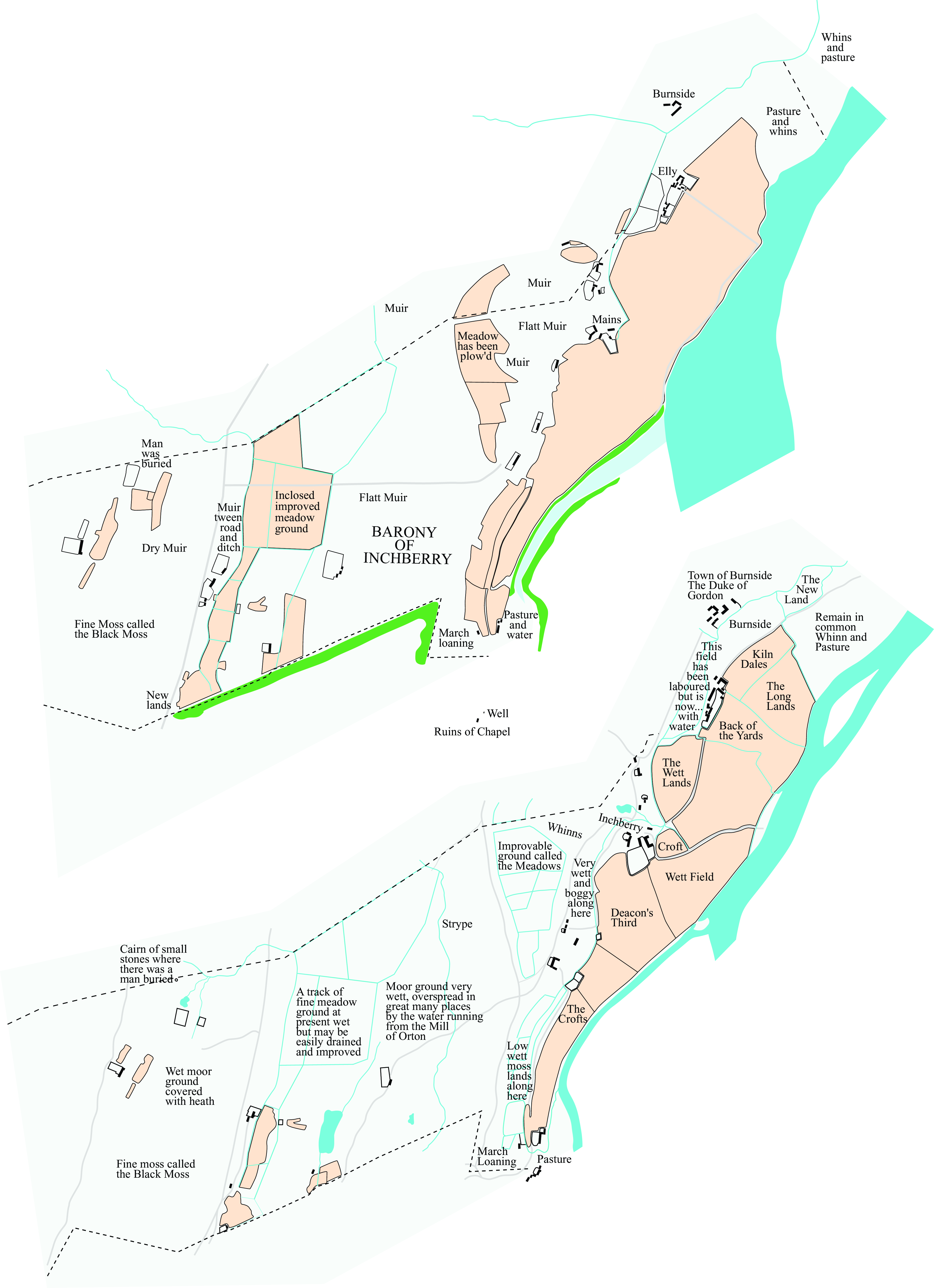
West side of the Barony of Inchberry c.1806 (top) c.1775 (bottom).
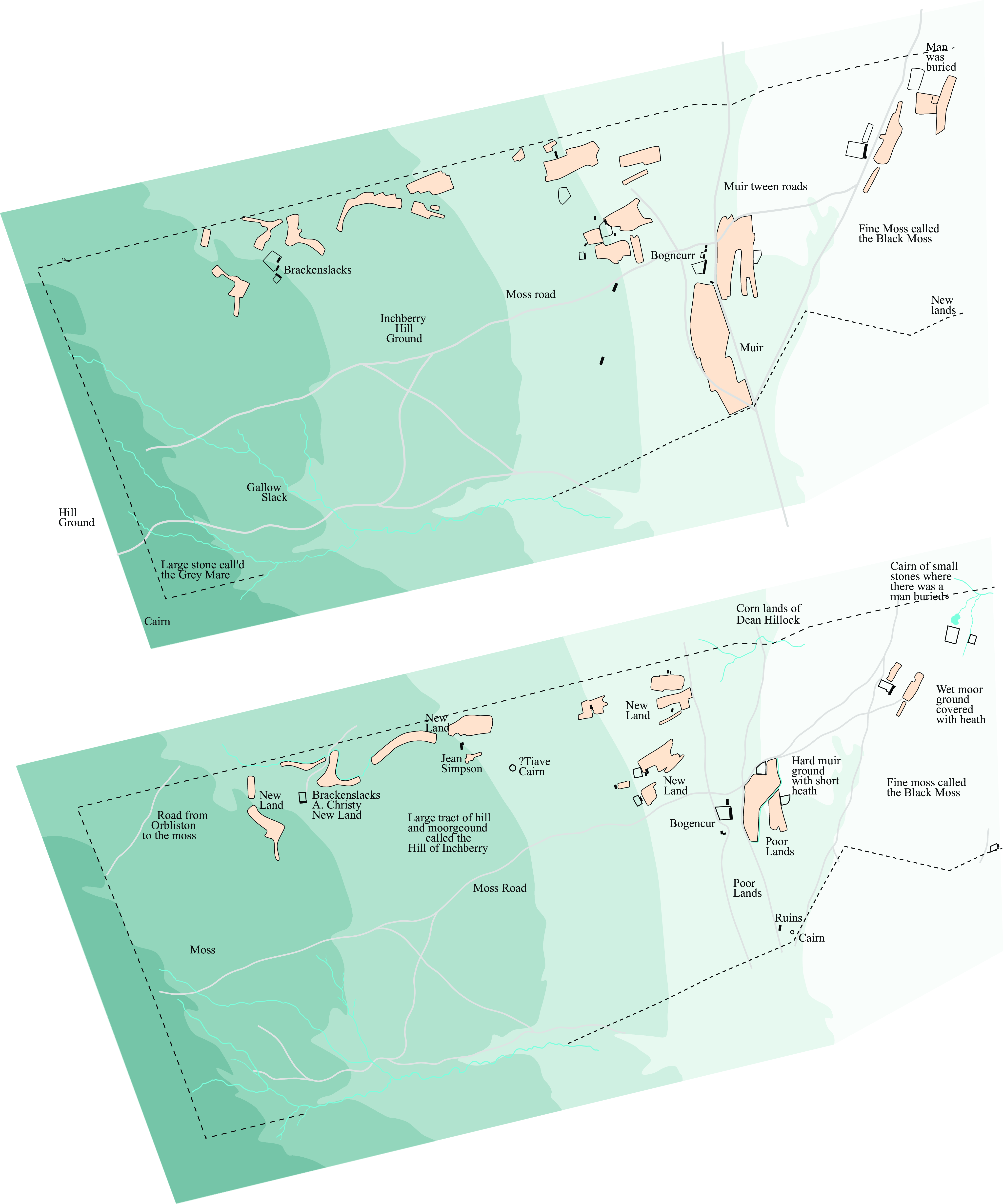
Bogencurr and the nearby farming units display the same developmental pattern noted elsewhere in the Barony – enhancement of buildings and expansion of fields and yards. And this pattern extends up onto the higher grounds around Brackenslack – another topographical name indicating the ferny nature of the drainage slacks in the locality. Confusingly, the Brackenslack noted on the later 1st edition Ordnance Survey map and subsequent editions lays some way to the south, beyond the lands of Inchberry.
The earlier plan makes it clear that all of these lands up on the hill were considered ‘New Lands’ at the time. Brackenslacks was held by an A. Christy and a smaller apportionment to the east by Jean Simpson, suggesting that lady tenants were perfectly capable of ‘riving in’ a bit of new ground. By the time of the second plan, Jean’s house had disappeared and the lands, presumably, had been engrossed by Brackenslacks. Its buildings displayed the development recognised elsewhere. Alternatively, Jean or her successor may have simply moved closer to Brackenslacks. The one house and yard there had developed into two buildings around a bigger yard and a separate building with attached yard. This may have been a separate tenancy.
The fields were still shown here on the 1st edition OS map, along with an unroofed range of buildings, but this farmstead was un-named. It should be noted that, even at this date, the fields were hemmed in by forestry plantations. By the time of the survey for the second edition, carried out around the turn of the century, nothing seems to have remained of the fields or the buildings. The entire area was covered with trees. Clearly, this small settlement had succumbed and nothing can now be easily seen of it in the present Forestry and Land Scotland woodlands. All that has survived is a portion of a hollow way running from Bogencurr up to the hills above and the remains of a cairn noted as ?Tiave Cairn (the writing is hard to read) on the earlier plan. This is not shown at all on any subsequent plans, prior to being re-recognised recently (DES, 2013, 133). Higher up the hill beyond Brackenslack, a road from Orbliston to the moss shows that indwellers of Orbliston had rights to collect peat here at the time of the first plan. The bounds of the Barony on the hill were marked by another cairn of stones and a large stone ‘call’d the Grey Mare‘.
Conclusions drawn from the Inchberry estate plans
These two interesting estate plans give a means of understanding the development, through time, of one small estate on the edge of the River Spey close to its outflow to the sea. The non-forested lands are now rich barley lands, providing high-quality malt for the whisky trade. In the mid-18th century; however, they were very different. Most of the Barony consisted of meadowland and pasture. However, it is apparent that a lot of energy had already been spent on draining the lands to make them pastorally very productive.
Little substantial change occurred between the two surveys although, right across the estate, there are signs of incremental development of fields, yards, and housing. Furthermore, on the hillside, new lands had been taken in from the waste by a couple of enterprising people. Eventually, their efforts would disappear, presumably because of the relatively poor quality of the land. But, the settlement survived for a good many years and, possibly, inaccessibility may have been as much a cause of its demise as a lack of fruitfulness.
It is difficult to imagine that these settlers were there without permission of the heritor – the inclusion of their names on the plan suggests they were lease holders. They were clearly too remote from the Mains to have supplied labour service and they were presumably paying rent in kind or as cash. The description of their lands as new lands indicates that those settlements are unlikely to have existed for long prior to the first survey. However, it should be noted that further south, in Orton, a forestry worker, fairly recently (2015), discovered a lovely quern stone on a plateau overlooking the Spey. The object is difficult to date owing to the long period such items were in use – from prehistoric to early modern times. So, it may not be impossible that the Brackenslack tenants were opportunistically re-using an earlier settlement area. The indication of the plans of former ‘labouring of the ground’ reflected in earlier rigs should be born in mind in this context. The nearby place-name Rosarie may suggest ‘headland of the shielings’. Although no further evidence attests such shieling activity, the uplands of Rosarie became the site for numerous small rentier farmsteads dating to the 19th century, the remains of which are still prominent in the woodlands there.
The evidence from Inchberry, therefore, suggests a dynamic and enterprising class of late 18th-century rentier farmers who were adding value to their holdings whilst others were bringing new lands into cultivation. This was, therefore, a bottom-up investment in their holdings on the eve of a more extreme top-down industrialisation of the farmed landscape. The Inchberry plans suggest an increase in number of houses and barns and, presumably, an increase in the number of people leasing farming units. This was soon to be curtailed by the top-down development of larger farming units and the eviction of those small tenant farmers responsible for the series of developments examined here. These enterprising individuals were to be forced into waged labour. This, in turn, begs the question of whether some of the newly acquired lands, such as Brackenslacks, were genuinely unprofitable or whether they simply fell foul of the urge to rationalise and create an estate more in keeping with mercantile principles, changed social ideologies and the development of a revised set of aesthetic landscape ideals.
Discussion
The documentary and cartographic evidence detailed above suggests that ‘encroachment onto the waste’ had been a fact of rural life in north-east Scotland from at least the 1400s. That some was illicit whilst, probably, the majority was considered licit is also indicated by the data. What may be important to the discussion are the tenurial practices connecting heritor and tenants. What were the economic practicalities of ‘riving in’ new lands for the various participants?
Firstly in this respect, the North-east’s pre-industrialised society may be said to have fitted well with Adam Smith’s idealised framework: ‘The most advantageous employment of any capital to the country to which it belongs, is that which maintains there the greatest quantity of productive labour, and increases the most the annual produce of the land and labour of the country’. (324). The numerous small tenancies that made up the agricultural environment of the north-east certainly ensured the greatest quantity of productive labour. Moreover, the area was expanding and producing an exportable grain surplus whilst, at the same time, from the 1600s was expanding its beef product to satisfy England’s seemingly insatiable desire (Koufopoulos, Reference Koufopoulos2004). This is not to say that this system would have been proof against the effects of subsequent cheap imports and the periodic crises caused by weather – but, neither would be the new industrialised farms. The agriculture of the North-east, prior to industrialisation, was sustainable, ecologically friendly and tolerably egalitarian – very egalitarian when compared with what lay in store.
However, as we have seen, heritable tenancies were outlawed by the Court of Session in Scotland, though heritors often pushed at the edges of those laws and granted tenancies for lifetimes and, in the case of one example from Lonmay in 1793 (MS 1160/17/31) for the life of an heir as well. This would have given the security necessary for tenants to feel that investments in improving their holdings were potentially viable. And the bottom-up expansion at Inchberry reflects a desire to increase the usable area of individual estates by smaller tenants. Experience of ‘riving in’ new farmlands had been gained over hundreds of years and was nothing new. In other words, this was a dynamic and enterprising agricultural environment on the eve of its destruction by the industrialisation of the countryside. The causes of this dynamic expansion probably emerged from a rapidly increasing population, the climatic considerations noted above and large landowners who increasingly required cash to engage in a new political environment occasioned by the union of the Scottish and English parliaments in 1707. Taylor notes this with respect to the Gordons – important heritors in both the Highlands and the North-east (Reference Taylor2016, 16–17; 258). Accommodation was needed in London in order to oversee political interests there and, increasingly, conspicuous consumption was required to underpin social standing as a local development of Johnson’s ‘Georgian Order’ (Reference Johnson1996).
Back on the farm, agreements of hire, made between tenants and lesser tenants, occasionally made their way into the court records. This was usually when one party, who had agreed to a contract, failed to meet the required conditions. In 1632 William Gordon, a herd, had failed to take up his post as agreed (between Rood Day [3rd May] and Martinmass [11th November]) and was being pursued for damages – in effect, the wages that he had taken but failed to work for. These were detailed as three and a half bolls of meal, three ells of new grey cloth, three ells of ‘Harden’ (coarse cloth), 2 pairs of new shoes and two marks in money. An interesting aspect of this contract lies in the quantity of cloth and footwear. It seems unlikely that a herd would be getting through two pairs of shoes and six yards of cloth in a season. It suggests that wages paid by an estate frequently consisted of items rendered to the estate as rent from other tenancies. An account of 1718 from the Pitfour estate of James Ferguson (MS3816/2/2/1) demonstrates that rents accruing to the estate amounted to £365.12.10d, but that payments in kind added up to £362.12.0d. The only cash that actually changed hands to balance the account was £3.00.10d. In other words, most of the economy was cashless.
In 1642 (ASC 3, 6) Janet Walker had failed in her contract and was indebted for 5 marks, 5 quarters of grey cloth, 2 pairs of shoes, 3 quarters of linen and a pair of hose. Further up the social ladder, a non-entry case was brought against Androw Smith in Meikle Kowburtie, Pitsligo for failure to enter the ‘Milne of Auchline and the landis of Litill Kowbourtie callit Kowbourtie Keith’.(ASC 3, 37). Of interest are service renders: ‘ane sufficient leit of peitis yeilie on his awin expenssis ane bandwinn of huikis (enough reapers to service one binder) ane day in harwest yeirlie and to harrow sex bollis of ait sawing (probably approximately 6 acres) yeirlie’ as well as carrying victuals, slates and lime and unloading timber at Fraserburgh. Finally, in 1642 Alexander Riddell in Auquhathe failed to enter a house and a croft as contracted. (ASC 3, 41). For the rent of a house and ‘croft’, comprising a yard and 4 bolls of arable land (approximately 4 acres), he owed the daily service of his wife and himself. (This was valued at 6s8d per day.) In other words, no cash was included in his contract.
In other words, many tenancy contracts existed entirely without monetary considerations and, even when money was noted, the off-setting against other goods and services rendered the transaction virtually cash-free. Within this socio-economic framework, the expectation of finding documentary evidence for the ‘riving in’ of new intakes must be low. Thus, according to the old adage, absence of evidence does not equate to evidence for absence. Prior to a ‘new order’ of agricultural accountancy associated with the industrialisation of an enclosed landscape, such ‘encroachments’ rarely make it into the documentary records. Only when such an occurrence was considered a misdemeanour might they enter the records of the courts. In most of those instances, therefore, they recount illicit encroachments. In all likelihood, the licit ones are very under-represented in the documentary dataset but, as we have seen, may be more apparent in the cartographic record.
Conclusion
Encroachment onto the waste took many forms in the pre-industrialised farmscape of North-east Scotland and can be seen to have been occurring since court records became more commonplace in the 15th century. It appears to have been usual practice for lairds and their tenants to permit cotters and grassmen to place their ‘biggings’ on areas of waste ground. These might be within the infields or beyond them. Only when lairdly fears about the threat to their waste as potentially reducing the profit to be taken from that land was the practice curtailed. A cultural background of utilising the practice of convertible husbandry – infield/outfield – and transhumance to accommodate demographic and climatic change presumably helped to make periodic encroachment acceptable to landowners and tenants alike.
The low-status encroachments should be considered separate from those instances of lairdly attempts to appropriate larger tranches of undivided commonty that also periodically occurred. In other words, not all encroachments – either licit or illicit – represent similar social actions. Often it was the lordly initiative of engrossment that fell foul of the law. As waste ground acquired greater worth during the course of the 18th century, encroachments that formerly would have evoked little discussion became increasingly associated with the notion of illicit squatting. As we have seen, the practice had occurred since before records became more frequent in the 15th century and was frequently – though not always – carried out with the landowner’s blessing.
Ignoring the lordly attempts to increase the size of their estates, encroachment occurred in order to provide dwellings for increased numbers of people working on the land, as part of the traditional use of convertible husbandry, or as a means of bringing new lands into cultivation and thus capable of paying a rent. However, the cartographic evidence demonstrating the return of formerly laboured land to waste shows the process to have been non-linear. The late 18th-century evidence from Inchberry suggests that land improvement, prior to the large-scale, proprietor-driven industrialisation of the landscape, was often driven by rentier farmers increasing the size of their holdings, alongside new tenants riving-in new plots for themselves. In other words, in the context of a dynamic and developing agricultural economy. Many of the cotters responsible for building dwellings in the waste did so with the agreement of tenant farmers, who were given permission to allow such biggings by the landowner.
During the course of the 18th century, strictures against such practices become more evident in the court records. Consequently, there appears to have been a gradual change in the perception of the landowners from one of acquiescence to one of hostility during the course of that century. Perhaps there might be discerned a positive correlation of hostility with the perceived monetary value of the waste. This may have been further fuelled by an ideological shift amongst the upper classes embracing a new ‘Georgian Order’, in which convertible husbandry smacked too much of rusticity and backwardness.
This paper has explored the possibility of using documentary and cartographic evidence to understand the context of encroachments onto the waste in the North-east between 1400 and 1800. Further work within the archives looking at other court records may well clarify the picture still further. But, in the absence of discovering a hitherto-unrecognised library, Oram’s plea (Reference Oram, Dixon and Theune2021) for greater environmental research probably reflects the most advantageous approach to understanding the development of the landscape and the roles of the different actors therein. And, although proxy data can be employed, spatially discrete, datable evidence is needed to interrogate the local nuances that appear to be such a feature of the various landscapes within the North-east. At present, such work has barely begun.
Acknowledgements
Many thanks to the two anonymous reviewers for their insightful comments and many excellent suggestions for improving this paper; they were much appreciated. All remaining errors are all my own work!


 Open access