


Introduction
Through ever greater routine application of radiocarbon dating, the recognition of cut features of Mesolithic age is notably increasing (Achard-Corompt et al. Reference Achard-Corompt, Ghesquière and Riquier2017; Blinkhorn et al. Reference Blinkhorn, Lawton-Matthews, Warren, Achard-Corompt, Ghesquière and Riquier2017). Pits provide one category. Often without a strong artefact component, but with complex fills, substantial pits with diameters above 2.0 m and depths exceeding 1.0 m are now recognised as a distinct Mesolithic feature ‘type’ in northern France, eastern Scotland and England (Achard-Corompt et al. Reference Achard-Corompt, Ghesquière and Riquier2017; Conneller Reference Conneller2022, 226–9; Pollard Reference Pollard2017). Among the first of these to be securely dated to the Mesolithic are the so-called postholes adjacent to Stonehenge (M. Allen Reference Allen, Cleal, Walker and Montague1995; M. Allen & Gardiner Reference Allen, Gardiner, David and Wilson2002), now, perhaps, to be considered pits with substantial ‘pipe-like’ recuts (Pollard Reference Pollard2017). Recent development-led fieldwork is making evident the frequency of occurrence and landscape context of substantial pits, and is revealing their presence as both isolated and grouped features, the latter including the linear setting at Warren Field (Murray et al. Reference Murray, Murray and Fraser2009) and the extensive cluster at Milltimber (Dingwall et al. Reference Dingwall, Ginnever, Tipping, Van Wessel and Wilson2019), both on the River Dee, Aberdeenshire. While yet to be fully matched in the British Isles, extending over an area in excess of 1 km in length, the clusters at Recy/Saint-Martin-sur-le-Pré in the Champagne region (Achard-Corompt Reference Achard-Corompt, Achard-Corompt, Ghesquière and Riquier2017) have highlighted the considerable landscape scale of some of these pit sites, and with it the need to approach, where possible, investigation through extensive prospection and/or excavation techniques.
Understanding the role that pit digging played within the Mesolithic – variously the assignment and definition of ‘functional’ roles versus arguments for more symbolic or cosmological motivations – is a challenge (Blinkhorn et al. Reference Blinkhorn, Lawton-Matthews, Warren, Achard-Corompt, Ghesquière and Riquier2017), much as with the case for pits of Neolithic date (Anderson-Whymark & Thomas Reference Anderson-Whymark and Thomas2011). Here we report on the largest Mesolithic pit cluster discovered to date in the British Isles, at Linmere, north of Houghton Regis, Bedfordshire. Due to the presence here of large numbers of broadly contemporary pits, their mapping through landscape-scale exposure, and the opportunity afforded to relate the pits to topography and natural features such as palaeochannels, it has been possible to develop new interpretations of their function and cultural significance.
Setting, background to investigation, and methodology
The excavations were undertaken by Albion Archaeology and MOLA in advance of residential development at Linmere, north of Houghton Regis, Bedfordshire (TL 02875 25684) (Figure 1). Located on the Bedfordshire chalklands forming the northern limit of the Chilterns, the topography of the area of investigation is relatively flat at c. 115–130 m OD, with the excavated pits occupying a slight east–west ‘plateau’ or bench within this zone. To the north, the ground slopes down to the Ouzel Brook, while a clay-capped chalk ridge rises to the immediate north of, and runs parallel to, the brook. The solid geology is chalk of the West Melbury Marly Chalk Formation (BGS). Deposits of alluvium, up to 1.0 m thick, were present along the northern edge of the investigated area, but did not extend over the pits, which were sealed by ploughsoil.
Linmere: site location, showing areas of excavation (2019–21), the line of the Ouzel Brook and the position of the Grove Farm flint scatter.

Various physical aspects of the location could have made Linmere an attractive and distinctive location within the regional landscape during the Mesolithic. Stream and river systems likely afforded easy routes of long-distance navigation and movement during prehistory (Bell Reference Bell2020), as well as resource-rich zones attracting wild fauna, wildfowl, and diverse plant species, so the position of Linmere in relation to the origin point of several streams is of interest. The Ouzel Brook now rises a little over 0.5 km to the south-east (its source location may have been different in the Mesolithic) and feeds into the River Ouzel, itself a tributary of the River Great Ouse, draining into the Fenland Basin 50 km to the north-east. Another tributary of the Great Ouse, the River Ivel, has a principal source in the River Flit, which rises under 1 km to the north-east at Chalton, while 1 km to the south is the source of the Houghton Brook, a tributary of the River Lea, which bisects the Chilterns and feeds into the Thames at Bow Creek. Geologically, the site sits close to the junction between the chalk uplands of the Chilterns to the south-east and the mudstones and sandstones to the north-west.
The closest Mesolithic site to the pit cluster comprises a large flint scatter identified through surface collection on the south-facing slope of a clay capped ridge c. 300 m to the north-west, on the opposite side of the Ouzel Brook, near Grove Farm (Hudspith Reference Hudspith1991). This is not reported in detail, but included blades, flakes, flaked axe fragments, scrapers, and cores, while a more dispersed distribution of Mesolithic flintwork was present further east and south (Hudspith Reference Hudspith1991, 58). The published plan of the scatter suggests its core could extend over 6 hectares, representing a locale returned to over a long period of time with a significant, if intermittent, residential component. Contemporaneity with the pit cluster cannot be ascertained, but the longevity of the activity associated with the pits, and the frequent ‘persistence’ of scatter sites, makes overlap/contemporaneity likely. Other evidence for prehistoric activity within the environs of the site was recorded during fieldwalking adjacent to the M1, c. 1.2 km east of the development area, comprising flint scatters of Mesolithic to Bronze Age date (Albion Archaeology 2012).
The Mesolithic pits were investigated between 2019 and 2021 during different phases of work ahead of construction of advanced infrastructure works, mainly roads and services, and adjacent housing development. Fifteen certain and probable Mesolithic pits were recorded during the Albion work and 13 by MOLA in 2021 (Figure 2). The Albion pits have been reported (Luke & Kozimiński Reference Luke, Kozimiński, Luke and Shotliff2023), but further analytical work has been undertaken for this paper. The excavation methodology involved strip, map, and sample exercises (Figure 3), with the areas of investigation being mechanically stripped without sampling of the overlying ploughsoil. All but one of the pits were excavated to their full depth and at least half-sectioned. Details are given in Table 1. Development work in the immediate vicinity is ongoing and may continue for some time. During the preparation of this paper a further 18 pits of suspected Mesolithic date have been excavated (the locations of 14 of these are shown on Figure 2), bringing the total to 46 (as of January 2026). These more recently investigated examples will be reported on separately. Further pits may well appear as development-led investigation continues.
Linmere: distribution of Mesolithic pits (2019–21 and 2024–25), topography, the course of the Ouzel Brook and its earlier channels, and the Grove Farm flint scatter.

Linmere: aerial photograph (from south) showing the western area of the Albion excavations and channel C.

Summary details of excavated Mesolithic pits. Key: RCD = radiocarbon date, C = charcoal, H = hazelnut. Pit reference refers to the numbers used in Luke & Kozimiński (Reference Luke, Kozimiński, Luke and Shotliff2023) and Wolframm-Murray (Reference Wolframm-Murray2024)

Excavation results
Within the footprint of the stripped area, the pits are distributed across a zone c. 850 m east–west by c. 250 m north–south (including those revealed since 2021), corresponding broadly to the 120 m OD contour (Figure 2). While not present in any great density, a range of other anthropogenic features were also identified, including two Earlier Neolithic pits, Middle Bronze Age to Early Iron Age settlement features, and ditches of a Roman field system (Luke & Kozimiński Reference Luke, Kozimiński, Luke and Shotliff2023; Wolframm-Murray Reference Wolframm-Murray2024). A number of natural features have a closer temporal relationship to the Mesolithic pits. Principal among these is a series of palaeochannels. The main east–west channel follows the course of the Ouzel Brook. Running off the southern side of the main channel are three broadly north–south aligned lateral channels (numbered A to C, from east to west), likely formed by springheads feeding into the brook when it was a more substantial watercourse. Channels B and C were sampled as part of the Albion excavations and shown to be 10–18 m wide and up to 1.85 m deep, being deepest as they approached the Ouzel Brook to the north, but reducing in depth to 0.1 m to the south and surviving intermittently (Luke & Kozimiński Reference Luke, Kozimiński, Luke and Shotliff2023, 46) (Figure 3). No dating evidence was obtained, but the close correspondence with the setting of Mesolithic pits and the spatial respect shown in the alignment of Iron Age and Roman ditches would suggest these were long-lived features with origins in the Late Pleistocene to Early Holocene when the channel loads were likely greater.
A considerable number of tree-throw holes occurred across the stripped area. Their distribution is discontinuous, with a notable drop-off in numbers on the lower ground towards the Ouzel Brook, and significant concentrations at the southern ends of channels A and C, where damper conditions may have made tree root systems more susceptible to wind throw. Selected tree-throw holes were sampled by hand excavation. Two in the central area and one close to the eastern edge produced worked flint of Mesolithic age, including cores and blades, suggesting their formation may date to this period. Others could be of much later date, even if still prehistoric. Pits 6 and 9, for example, were cut by tree-throw holes.
For purpose of description, the Mesolithic pits are loosely grouped into five zones, running from east to west (Figure 4):
-
• Group 1: pits 1 and 2, east of channel A.
-
• Group 2: pits 3 to 10 flanking channel B.
-
• Group 3: pits 11 to 19, forming a loosely defined cluster between channels A and B.
-
• Group 4: pits 20 to 26, around the southern end of channel B.
-
• Group 5: pits 27 and 28 at the southern end of channel C.
Linmere: pit groups. Boxes show areas covered by detailed figures.

Group 1. Pits 1 and 2 (Albion Archaeology and MOLA)
Situated c. 90 m apart, Pits 1 and 2 occupy the zone to the east of channel A (Figures 5–6). The most easterly of the pits, Pit 1, was encountered during evaluation work by Albion Archaeology in 2012. Sub-circular, 1.9 x 1.6 m across and 0.8 m deep, with steep to moderate sides, it contained a sterile chalky fill. While not independently dated, it was cut through by a later prehistoric ditch and shares morphological characteristics with other Mesolithic pits.
Plan of pit groups 1 and 2, tree-throw hole with worked flint, and channel A.

Sections of Pits 1 to 10 (groups 1 and 2).

Pit 2 was notably larger at 3.64 m in diameter and 1.28 m deep, with uneven moderate to steep sloping sides and a flattish base (Figure 7). The primary deposit was a thick mottled white, grey, and brown silty clay, from which came a flint blade, a flake, and one fragment of bone. Overlying this were deposits of grey and grey-brown silty clay that extended to the top of the feature.
Photographs of Pits 2, 6, 14, and 19, half-sectioned.

At least one recut is represented (2A), filled by a dark-brown silty clay with charcoal-rich bands. Three unidentified animal bone fragments were recovered from this. An environmental sample produced quantities of charcoal, including poplar/willow and charred hazelnut. Over this was a dark grey-brown silty clay, with frequent shell and charcoal concentrated in its centre. A further flint blade was recovered from this fill. Sealing a slight depression was a layer of grey-brown silty clay.
Group 2. Pits 3 to 10 (MOLA)
Pits 3 to 10 (Figures 5–6) formed a broadly linear arrangement running NNW–SSE over c. 100 m alongside channel A. Pit 3 was situated against the eastern edge of the channel at a point where its course veered slightly to the west, while Pits 4 to 10 ran alongside and to the immediate south of the western bank of the channel. Pits 5, 6, and 7 were set only c. 2 m apart, the others spaced at intervals of c. 12–20 m. Despite the appearance of a purposefully constructed alignment, it remains unclear whether all the features were contemporary or represent successive episodes of pit digging, their line being dictated by that of the channel.
The pits ranged in size from 1.5–3.85 m in diameter, and 0.6–1.85 m in depth. If the abnormally smaller, shallower and rather irregular Pit 9 is excluded, then the size ranges run from 1.85–3.85 m in diameter and 1.3–1.85 m deep. With the exception of Pit 9, which possessed an irregular profile, the features were characterised by steep sides and flat bases. The sides of Pits 3, 5, 6, 7 and 8 splayed out in their upper profiles, the result of weathering back of the exposed tops (Figures 6–7). Pit 3 was unusual in being relatively narrow and possessing near-vertical lower sides, the diameter when first cut being around 1.0 m.
The pits had between seven and 13 deposits formed in four distinct phases. The primary cuts were filled with relatively thin alternating bands of primary silting or in-wash, comprising lighter mottled grey or yellow-brown silty clays and darker grey to brown mottled deposits of silty or chalky clays, the latter perhaps representing displaced topsoil. In the case of Pit 5, a small mound of pale silty clay had formed on top of the primary fills. Bone fragments from field vole and polecat were recovered from the primary fills of Pit 3 and unworked burnt flint from Pit 7. Charcoal flecking was common in all, suggesting a ‘background’ presence of burnt material across the area.
A second phase of infill comprised similarly alternating bands and thicker slumped or deliberate backfill deposits, especially notable in Pits 3, 4, and 8. The latter consisted of both pale, chalky silty clays along with dark/grey-brown chalky and silty clays. From these deposits in Pit 5 came large mammal rib fragments. A left aurochs femur was recovered from a mottled dark grey silty clay above this. Finds were otherwise sparse within the secondary fills, but included the proximal end of a flint blade from Pit 9.
All but Pits 3, 9, and possibly 6 had identifiable recuts coming from high in the fill sequences. These generally took the form of pits with moderately sloping sides and concave bases infilled with single or multiple deposits of grey-brown or mottled light, mid, and dark grey/grey-brown silty clay. Four phases of recutting were recognised in Pit 4, the first (4A) extending deep into the earlier fills. This contained four pieces of worked flint, including a blade. Truncating the top of this was the second recut (4B), from which came part of a large aurochs scapula. There were two further, though much shallower, recuts (4C and 4D). The fill of 4C contained fragments of aurochs sacrum, and a roe deer calcaneum and other bone fragments were recovered from the fill of 4D.
Pit 5 was recut on at least two occasions (5A and 5B), both with bowl-shaped profiles. Sealing these was a thick dark brown silty clay, perhaps in a broad recut of its own (5L), from which came the left and right innominates of a wild boar and four medium mammal bones, as well as a core fragment.
Single recuts were present in Pits 7, 8, and 10 (7A, 8A, and 10A). These ranged from 1.1–2.2 m in diameter and greater than 0.4–0.95 m in depth, the largest in Pit 10. Two fragments of roe deer humerus and four unidentified fragments of medium-sized animal bone came from the fill of 8A in Pit 8. Filling the top of this in layer 8L were deposits of grey-brown silty clay, the lower producing a flint flake and the upper ten fragments of animal bone.
The final fills of the pits comprised layers of dark brown silty clay, the natural silting and soil formation of the depressions left as the earlier fills slumped and compacted. These deposits were disturbed occasionally by later cultivation furrows. Pits 6 and 9 were cut by tree-throw holes.
Group 3. Pits 11 to 19 (Albion Archaeology and MOLA)
Pits 11 to 19 (Figures 8–9) formed a dispersed group between channels A and B. Their grouping here should not imply any original coherence or connection, and they are described together for the sake of descriptive convenience. Pits 11 and 14–16 were investigated during the MOLA excavations, and Pits 12 and 13, and 17–19 during work by Albion Archaeology.
Plan of pit group 3 and tree-throw holes with worked flint.

Sections of Pits 11 to 19 (group 3).

There is a significant degree of variation in form and fill among these pits. Their diameters ranged from 2.2–6.1 m, and depths from 0.7–1.6 m. Located within several metres of each other, in a way that could imply pairing, Pits 12 and 13 were notably shallower than the others, being no more than 0.8 m deep, and their fill sequences less complex. Pits 14 and 18 stand out because of their widths, at 6.1 and c. 5.0 m respectively (Figure 7), but they were not significantly deeper than most. Pit 11 was unusual in having a markedly narrow profile. Generally, they possessed flat or slightly dished bases and very steep to near vertical lower sides, the upper parts of the profiles tending to splay out due to weathering. Pit 14 possessed more moderately sloping sides than others. Pit 16 was partially excavated and its full depth not established.
The fill sequences show paler, more calcareous primary and secondary fills (whitish, light grey, yellow-brown silty clays) indicative of weathering of the sides, and darker ‘tertiary’ upper deposits. Within the primary fills were layers of mottled grey-brown silty clay that could represent slips of surrounding soil into the fills. In Pits 14 and 15 there were thicker primary deposits, a pale grey silty clay in the case of Pit 14, and a brown chalky silty clay in the case of Pit 15. Five blades and three flakes came from the latter, and a flint flake from the lower deposit in Pit 16. Fragments of large mammal bone were recovered from the secondary fills of Pits 13 and 18.
Thicker upper fills of several of the pits could represent backfill events, or at least rapid deposition of homogenous deposits. In the case of Pit 15 this included a thick layer with a more soil-like character, overlain by a substantial layer of grey-brown silty clay with chalk concentrated towards the centre. From this came a flint core fragment, three fragments of large animal bone, and fragments of an aurochs radius. From a thick, dark, and humic deposit sealing this came a blade core, two flakes, two shatter fragments, and small debitage.
Recuts were identified in Pits 11 (three), 14 (two), and possibly 19. Given the complexity of the upper fills of a number of the pits, this must be regarded as a minimal identification. In the case of Pit 14 a very substantial flat-based recut (14A) was almost equal in diameter, if not depth, to the original pit, at 5.8 m across and 1.2 m deep. Its lower fill was a grey-brown silty clay/mottled chalky silt, from which came a flint flake; the upper fill comprised dark grey silty or chalky clays, one of which contained three fragments of red deer antler. A second, smaller, recut (14B) was centrally set. The pit was U-shaped, and greater than 2.6 m wide and 0.6 m deep with a concave base. It was filled by five deposits of grey and dark grey silty clay. A flint flake and shatter fragment, and animal bone fragments including an aurochs humerus and femur from at least two different animals, were recovered from 14B. Within the hollow left by the partially filled Pit 14, and sealing the recuts, was a thick soil-like deposit of dark brown silty clay from which came three blades, two flakes, two shatter fragments, as well as fine debitage, a femur fragment from a large animal, and hazelnut shell.
Two localised recuts, 11A and 11B, were identified in the central and southern parts of Pit 11. A larger recut, 11C, was centrally placed, with moderate sloping sides and a slightly dished base. The lowest fill comprised mixed black silt and chalky silty clay, sealed by a grey-brown silty clay, from which came a range of animal bone, including three aurochs humeri, five roe deer teeth, a roe deer humerus, and two unidentified large mammal bones. This deposit was overlain by weathered, dumped or slumped layers of grey-brown, white, mottled dark brown-grey and light brown-grey silty clays and chalky silty clays, possibly sat within further shallow recuts.
A substantial (c. 2.9 kg) deposit of animal bone from the secondary fills of Pit 19 may also have been set in the base of a recut (unnumbered due to its tentative status) (Figure 7). Most of the identified elements were from at least one, probably two, aurochs. Cut marks on two humeri provided evidence for dismemberment and possibly filleting. Twelve flint blades of probable Late Mesolithic/Early Neolithic date were recovered from the pit, as well as hazelnut shell and charcoal.
A tree-throw hole cut the north-eastern edge of Pit 15 and a furrow the upper fills of Pit 14. Two small tree-throw holes to the north-east and south-east of Pit 14 produced small quantities of worked flint.
Group 4. Pits 20 to 26 (Albion Archaeology)
Set over a distance of c. 100 m at the southern end and to the west of channel B, this group comprises a ‘pair’ of pits (20 and 21), an arc of four (22–25), and one outlier (26) (Figures 10 & 12). Pits 20 and 21 were set at the very end of the channel, the latter dug into its fills.
Plan of pit group 4, Early Neolithic pits and channel B.

Plan of pit group 5 and channel C.

Sections of Pits 20 to 28 (groups 4 and 5).

Pit 20 was similar in size and profile to those of the ‘arc’ described below, being 2.5 m in diameter and 1.0 m deep, with a relatively homogenous grey-brown silty clay fill. By contrast, Pit 21 was the most substantial of the group, at 4.3 m in diameter and with a depth of c. 1.7 m, possessing steep sides that were slightly stepped towards the flat base. Like many others, it was filled with lighter, chalk-rich primary and secondary fills, and darker tertiary fills. The tertiary fills may have sat within a recut, and from the fills of this came two flint blades and animal bone, including fragments of aurochs mandible, a red deer tooth, and a roe deer ulna.
Pits 22–25 were arranged c. 3–8 m apart in a broad arc that extended over c. 30 m to the west of the southern end of channel B. Circular or sub-circular, 2.1–3.2 m in diameter and 0.9–1.7 m deep, all except Pit 25 had steep to near-vertical sides and flat bases. Their fills typically followed a pattern of lighter, chalk-rich primary and secondary fills – those of Pit 23 including distinct light and dark bands – sealed by darker tertiary fills. Possible recuts occurred in the upper parts of the fill sequences in Pits 23 and 24. Potentially set within a recut, a large assemblage (c. 4.8 kg) of animal bone, including parts of two aurochs skulls, came from Pit 23. Fragments from an aurochs horncore were also present in Pit 25.
Pit 26 lay c. 50 m to the west of the arc defined by Pits 22–25. It was similar in size and profile, with a more concave profile and a more homogenous grey-brown silty clay fill. Two small pits of probable Early Neolithic date were present in the environs of Pits 22 and 23, and channel B (Figure 10).
Group 5. Pits 27 and 28 (Albion Archaeology)
Pits 27 and 28 (Figures 11 and 12) were located c. 50 m apart in an area of dense tree-throw holes. Pit 27 was set at the southern end of channel C (a similar relationship to Pit 21 and channel B), while Pit 28 was c. 30 m to the west of the channel. Pit 27 was sub-circular and Pit 28 oval, with similar steep sides, flat bases, and sterile chalky fills.
Finds and environmental analyses
The radiocarbon laboratory methodologies, OxCal code, notes on the radiocarbon phase model, along with reports on charcoal and charred hazelnut shells, mollusca, and pollen are contained in the supplementary data (Supplementary S1–S6).
Radiocarbon dating (by Chris Chinnock)
A total of 18 radiocarbon measurements are available. Seventeen samples of unburnt animal bone were submitted, three to Beta Analytic and 14 to SUERC. A single sample of charcoal was submitted to SUERC. The results and sample information are presented in Table 2. The methodologies used by the laboratories can be found in Supplementary Material S1.1. The results reported are conventional radiocarbon ages (Stuiver & Polach Reference Stuiver and Polach1977). Dates presented in Table 2, and throughout this report, have been rounded outwards to the nearest ten years, as per guidance set out by Historic England (Bayliss & Marshall Reference Bayliss and Marshall2022, 10).
Radiocarbon date determinations. Numbers in brackets after pit number refer to labels shown on sections in Figures 6, 9, and 12

Sample selection
This analysis includes seven samples taken by Albion Archaeology as part of an earlier phase of excavation, alongside others selected by MOLA. Samples were chosen based on the nature and suitability of the available sample material and the associated context. The principal challenge faced during sample selection was the quality of the available material. Much of the faunal assemblage comprised disarticulated and poorly preserved single bones and, overall, the environmental assemblages from the pits were extremely limited with mostly poor association with the relevant contexts. The selected samples (Table 2) represent the most reliable of the available material and provide dates from across 13 of the pits. In the case of three pits, multiple samples were taken from stratified contexts. For these reasons it was not possible to examine the chronological relationship between any putative pit groups as part of the Bayesian modelling presented below, which considers them as a single related group of features.
Results
Bayesian modelling of this group of dates has been calculated in OxCal v4.4.4 (Bronk Ramsey Reference Bronk Ramsey2021), using IntCal20 (Reimer et al. Reference Reimer and Talamo2020). It assumes that once pits began to be dug at Linmere, they continued to be excavated and filled at a relatively constant pace for some period of time and then ended (Buck et al. Reference Buck, Litton and Smith1992). The model refines the statistical scatter of the radiocarbon dates to give a more appropriate representation of historical duration of the activity, and also formally estimates when the activity began and ended. Very few of the dated samples come from the primary fills of the original pits, which means that our sample of dated activity may be slightly skewed towards later infilling. This is not ideal. Similarly, given the number of features observed and the duration of the activity, the phase was clearly sporadic.
It should be noted here that the selected samples derive from various fills throughout long-lived fill sequences within the pits. Only Pit 25 provided material from primary fills that may more closely date the actual excavation of the feature. The range of sampled contexts relate to backfill and recutting events throughout the lifespan of the pits. For this reason, it was not thought appropriate to model the dates in line with the suggested pit alignments, but to rather treat them as one large group to get a broad idea of how long the pits were in use.
Multiple contexts were sampled from Pits 4, 5, and 19. The results of these samples have been presented as a sequence within the overall phase model presented in Figure 13. Within Pit 5, the results do not align with the recorded stratigraphic sequence. Two of the contexts from this pit have produced material that is older than material dated from stratigraphically earlier deposits, and so must be considered residual. This is reflected in the phase model below (see ‘After residual’; Figure 13).
Phase model displaying probability distributions for Mesolithic pits.

The modelled plot of dates (Figure 13) displays the refined dates and estimated start and end dates for pit use at Linmere. The large square brackets down the left-hand side of the diagram and the OxCal keywords define the overall model exactly. Shown in red in Figure 13, the model estimates that use began between 7610–7080 cal BC (95% probability; Boundary Start), probably between 7370–7130 cal BC (68% probability), and ended between 5290–4740 cal BC (95% probability; Boundary End), probably between 5210–4970 cal BC (68% probability). Figure 14 shows the estimated duration of pit use at Linmere to be between 1880–2740 years (95% probability; Span pit use), probably 2010–2390 years (68% probability).
Probability distribution of the pit use duration.

This model includes SUERC-111489, which is significantly later than the rest of the dates calculated (shown in green in Figure 13). Inclusion of this sample increases the estimated duration of activity, and the estimated date for the end of activity is pulled forward by approximately 500 years. Were this date to be excluded from the model as an outlier, then the model estimates filling of the pits began between 7520–7080 cal BC (95% probability), probably between 7330–7120 cal BC (68% probability), and ended between 5720–5350 cal BC (95% probability), probably between 5700–5550 cal BC (68% probability). Similarly, the estimated duration of pit use would be between 1400–2050 years (95% probability), probably 1490–1760 years (68% probability). The OxCal code for the model, which excludes this date as an outlier, is presented in Supplementary Material S1.2.
Radiocarbon dating discussion
The dates returned for the Mesolithic pits present a challenging picture of use over a period of around 2000–2500 years. The concerns raised within the stratigraphic record over recutting, root and animal disturbance, and residuality appear to be well founded. Where stratigraphic sequences were investigated within individual pits, the resultant dates demonstrate that residual material was present throughout the fill sequences.
In the case of Pit 5, four samples were submitted (Table 2). Based on the recorded stratigraphic relationships, two of the four dates must be residual and have been indicated as such in the phase model (Figure 13). This is true even for a sample taken from paired innominate bones from a wild boar, recovered from the slumping fill in the top of the pit (SUERC-111488). By contrast, the two dates from Pit 19 appear to be tightly grouped, indicating pit use around c. 6500 cal BC, towards the beginning of the Late Mesolithic period.
The two dates returned for contexts from Pit 4 are separated by roughly 1500 years. The two contexts are recorded as being separated by a recut of the pit. The disarticulated aurochs sacral fragment sampled from the later fill can either be considered intrusive, or represents re-use of these features many centuries after the main period of use. The inclusion or exclusion of this much later sample has a significant impact on the estimated end date and duration of activity, as detailed above. The model presented here assumes a relatively constant rate of deposition within the pits. Variations on this model, using different assumptions about the rate of deposition, were tested and found to have a negligible impact on the overall results (Supplementary S1.3).
Worked flint (by Yvonne Wolframm-Murray)
In total, 69 pieces (910.3 g) of worked flint were recovered from nine Mesolithic pits, five tree-throw holes, and as residual finds in later features (Figure 15; Supplementary S2.1–2.4). The assemblage comprises 16 flakes, 29 blades, three cores, three core fragments, five utilised blades, seven miscellaneous retouched flakes, two fragments, and four pieces of shatter (Table 3).
Two flint cores and microburin from tree-throw hole east of Pit 1.

Worked flint. Numbers are counts, numbers in brackets are weight in grams

The raw material ranges from light to dark grey and grey-brown with occasional opaque grey flint. Cortex is present on just over half of the pieces and is up to 1–2 mm thick, chalky or smooth, and generally light brown in colour.
The condition of the worked flint is good, though some artefacts show post-depositional edge damage consisting of occasional nicks to the edges. Patination is present on two-thirds of the flints, varying in degree from light grey-blue to white. Burnt worked flint is present, displaying thermal fracturing and crazing.
Mesolithic pits
Worked flint was found in ten pits, with over half from three features: Pits 14, 15, and 19. That from Pit 15 comprises 16 pieces, including a core and core fragment, blades, flakes, single retouched and utilised pieces, and two pieces of shatter (Figures S2.1–2.2). The primary fill included predominantly blades or blade fragments with limited evidence of abrasion preparing the striking platforms. There is one burnt proximal end of a blade. One blade has possible evidence of utilisation in the form of small removals on one lateral edge.
The core fragment from near the top of Pit 15 has a single prepared platform from which blades have been detached. Very little abrasion for platform preparation is visible. There is some crushing visible and possibly, after a step termination, it was abandoned. The remaining pieces of flint from the context above comprise fragments or pieces of shatter. Of interest is the medial section of a blade with removals on the proximal break that may indicate a notch, but there is also damage present.
Twelve blades were found in Pit 19 (Figures S2.3–S2.4). The characteristics are similar amongst objects from the three fills. Abrasion from platform preparation is evident on several. All blades are patinated; however, those from the lower fill are to a lesser degree. From this context come two blades with unpatinated removals that may have resulted from post-depositional damage. Four blades display possible signs of utilisation.
Eleven pieces of flint were recovered from Pit 14, comprising blades, flakes, fragments, one piece of shatter, and a natural piece of flint, the latter burnt. Two blades and one of the flakes show abrasion from platform preparation. All but one of the pieces are patinated, ranging from a slight discolouration of the surface to fully white.
The remaining 15 pieces of worked flint were found in six other pits. The characteristics of the material are very alike to those from the three pits described in detail. Of note are a core fragment, a flake, and a fragment that have small, retouched areas.
Tree-throw holes
Five tree-throw holes contained worked flint. One tree-throw hole, located to the east of Pit 1 produced five blades and a possible microburin (Figure 15). The possible microburin is on the proximal end of a probable blade, the distal end displaying a break adjacent to a series of small regular removals. Two of the blades are struck using a soft stone hammer, one of them having a small area of miscellaneous retouch. A second tree-throw hole north of Pit 1 contained two large cores (Figure 15), weighing 437.62 g and 101.42 g. The larger of the two has a partially prepared single striking platform and the other has prepared opposing striking platforms.
Flint discussion
The technological characteristics of the worked flint are in keeping with the Middle and Late Mesolithic dates for the pits. Regular blades are well represented and display evidence of preparation of striking platforms and the appearance of having come from single or opposing platform cores (Bates Reference Bates, Luke and Shotliff2023). Further evidence of the use of the area during the Middle to Late Mesolithic is provided by the dateable worked flint from two of the tree-throw holes, notably the possible microburin and the two blade cores (Figure 15).
Compositional variability across contexts can been seen in Pit 15, with the material from the lower, near basal fill, consisting mostly of blades with little fragmentation, whereas the assemblage from near the top consists of shatter, small debitage and broken flakes. This strongly suggests at least two depositional instances occurred.
The differences in patination in Pit 19 are likely due to different soil and burial conditions, the soil of less-patinated worked flint being less conducive to the promotion of the chemical changes. Crushing damage to the edges of one blade is likely to be post-depositional in origin, occurring during excavation. However, the second blade appears to have unpatinated retouch to the distal end. This may be later, but not considerably later, re-use of the blade.
The worked flint recovered from the pits does not include any formal tools (e.g. scrapers or microliths), although retouched and utilised pieces are present. The only evidence of tool production – the possible microburin – is from a tree-throw hole. While the more fragmented/flake-heavy assemblages from particular contexts (e.g. the upper fills of Pit 15) may be waste, it is not possible to be certain without undertaking microwear analysis, which was not possible within the current post-excavation programme. At Star Carr wear traces showed relatively large numbers of blades, flakes, and even shatter fragments had been utilised for plant-, bone-, and wood-working, suggesting ‘ “debris” was very much utilised in everyday activities’ (Conneller et al. Reference Conneller, Little, Garcia-Diaz, Croft, Milner, Conneller and Taylor2018, 533).
It is unclear whether any direct functional or depositional connection exists between the worked flint and the pits. Material may have weathered in from surrounding surfaces where it may or may not have accumulated as part of activities linked to the digging and use of the pits. However, some degree of intentional deposition can be posited, notably in the case of the two cores from the tree-throw hole north of Pit 1. Clearly by no means fully worked down, their large size may indicate an instance of caching.
Animal bone (by Chris Faine and Mark Maltby)
One hundred and ninety-three fragments of animal bone (c. 10 kg) were recovered from Mesolithic pit contexts at Linmere (Table 4). Fourteen pits yielded faunal material, with Pit 2 containing unidentifiable fragments only. The bones from the MOLA excavations were examined by Chris Faine and those from the Albion excavations were analysed by Mark Maltby (Reference Maltby, Luke and Shotliff2023). Aurochs were the dominant species in the assemblage (n: 53), with the majority of undiagnostic large mammal fragments recovered also presumed to be aurochs. In terms of aurochs body part distribution there is a clear pattern of disposal, with Pits 15–25 (in the centre of the site) largely containing crania/mandibles, in contrast to the assemblage from pit cuts 4B–14B to the east, which primarily contain upper and lower limb fragments (Table 5). Pit 19 in particular yielded fragments of two crania and a number of horncores, representing a minimum number of five individuals, with teeth from one maxilla indicating these included a neonate calf.
Animal bone: species distribution by pit, in Number of Identified Specimens (NISP)

Aurochs body part distribution by pit, by Number of Identified Specimens (NISP)

Pit 23 also contained crania from two animals (one male and one female), possibly interred some period after death due to the number of missing teeth (Figure S3.1). This leads to the possibility that there was some symbolic significance in their deposition in the pit. There are no reported examples from central England of the deposition of complete Mesolithic aurochs skulls (Albarella Reference Albarella2019); however, occasional depositions of aurochs skulls and horncores are known on Neolithic sites (e.g. Etton, Cambridgeshire: Armour-Chelu Reference Armour-Chelu and Pryor1998). In contrast, teeth are relatively frequent in contemporary Mesolithic assemblages. Around 25% of identified elements in the contemporary Cherhill (Grigson Reference Grigson1983), Misbourne (D. Allen et al. Reference Allen, Dalwood and Farley2022), and Stratford’s Yard (Stainton Reference Stainton1989) assemblages consisted of loose teeth. In terms of relative bone densities, most ungulate crania (aside from horncores) are lower than the majority of elements (Kreutzer Reference Kreutzer1992), and hence are subject to lower survivability rates. It is possible, therefore, that deposition of intact crania may have been more prevalent than the record suggests. Given the very high level of fragmentation in many contemporary assemblages, with respect to crania it may indeed be the case that the skulls from Pit 23 represent something other than waste disposal.
As mentioned above, material from the eastern group of pit cuts 4B–14B primarily yielded ‘higher quality’ meat-bearing upper limb elements (humeri, femora, and scapulae), notably from Pit 14B (n: 12).
Evidence for aurochs carcass processing from all deposits denotes marrow extraction, with midshaft chops and conical fractures noted. Cut marks on two humeri fragments from Pit 19 provided evidence for dismemberment and possibly filleting. Slight burning was noted at the midshaft break on a distal humerus from Pit 4D.
Given the body part distribution observed in the sample, the majority of measurements taken derive from distal long bones (notably humeri) and lower limb elements such as astragali. The majority of measurements are within Magnus Degerbøl and Bent Fredskild’s (Reference Degerbøl and Fredskild1970) and Elizabeth Wright’s (Reference Wright2013) ranges for Later Mesolithic animals in Europe and are comparable with those from British assemblages. Although fused elements from Pits 19 and 23 were probably from relatively young animals, the majority of available aurochs measurements from Linmere are relatively small. This reduction in size into the Late Mesolithic period can be seen at other contemporary sites (Albarella Reference Albarella2019; Wright & Viner-Daniels Reference Wright and Viner-Daniels2015), suggesting a possible bias towards hunting females, as well as an overall decrease in size. Given the differing body part distribution between Linmere, Cherhill, Misbourne, and Stratford’s Yard, few direct biometric comparisons can be made between them. However, where comparable elements were recovered from Linmere they were found to be of similar size. The fragmentary nature of much Later Mesolithic material means that comparison of sexual dimorphism between assemblages is also difficult. Analysis is often limited to examining groupings in suites of measurements, with the Misbourne metric groupings suggesting roughly equal numbers of males and females.
Roe deer remains (n: 10) were recovered from four contexts. Pit 4D contained a partial adult calcaneum. Pit 11C contained an adult humerus and partial maxilla of an animal around three years of age at death. An articulated partial humerus and radius were recovered from Pit 8A, with a portion of ulna noted from Pit 21. Red deer remains are limited to femur fragments and loose teeth from Pits 19 and 21 respectively, along with a portion of naturally shed antler from a young adult (minimum three years of age at death) from Pit 14A.
Wild boar remains are scarce, limited to a small (possibly female) femur from Pit 19 and two matching acetabula from Pit 5L. Measurements from these again suggest a possible female animal (Payne & Bull Reference Payne and Bull1988). Pit 3 contained a partial mandible and humerus from a medium-size mustelid, most likely polecat. The only microfaunal remains from the assemblage were also recovered from Pit 3 in the form of loose field vole mandibular teeth.
Anmal bone discussion
Substantial Mesolithic faunal assemblages from this area of the country are scarce, with the nearest published assemblages coming from Misbourne Viaduct, Cherhill, and Stratford’s Yard. Table 6 shows the species distribution of Linmere along with these three sites in terms of percentages. Larger assemblages from this period nationally include Star Carr (Legge & Rowley-Conwy Reference Legge and Rowley-Conwy1988), Thatcham (King Reference King1962), and Blick Mead (Rogers et al. Reference Rogers, Gron, Montgomery, Gröcke, Rowley-Conwy, Lyons, Jacques and Phillips2018). Although a number of species were exploited in the British Mesolithic, those that are most regularly represented are aurochs, wild boar, red deer, and roe deer, as also seen in the comparative assemblages. The Later Mesolithic saw a decline in red deer numbers (along with the widespread but not total disappearance of elk), with aurochs tending to be dominant at sites with dates after c. 7000 BC (Conneller Reference Conneller2022). These changes appear to have more to do with human hunting strategies than environmental change, as (aside from wild boar) most species lived in both forested, open, and mixed habitats (Yalden Reference Yalden1999). The dominance of a single taxon has also been noted as a feature of the regional comparative assemblages, and at Blick Mead (Rogers et al. Reference Rogers, Gron, Montgomery, Gröcke, Rowley-Conwy, Lyons, Jacques and Phillips2018).
Linmere species distribution compared to contemporary sites by Number of Identified Specimens (NISP)

Both adult roe and red deer were hunted for meat, with the former especially thriving in the mixed landscape of woodlands and clearings prevalent at the time (Yalden Reference Yalden1999). Wild boar remains are scarce, in keeping with the reduced numbers often seen in Later Mesolithic sites (Albarella Reference Albarella2019). Wild boar prefer woodland habitat, and any loss of tree cover would affect them. Wild mustelids (polecats/martens) were the most common medium-sized carnivore of the period, with their presence here most likely representing accidental deposition. Despite their (relatively) widespread presence in Mesolithic assemblages, there is little evidence of exploitation for fur in this period.
Discussion
A total of 28 pits of known and possible Mesolithic date were revealed during the excavations at Linmere and are reported on here. Ongoing work in advance of development has already extended that number to 46 (as of January 2026), their distribution extending over an area of 850 x 250 m, broadly following the course of the Ouzel Brook and set in proximity to a series of spring-fed lateral channels leading into the latter. They are united by their large size and shared sequences of infill. Spread across 21 ha, their spatial extent is greater than that of the more concentrated cluster at Milltimber on the Dee (at 5 ha: Dingwall et al. Reference Dingwall, Ginnever, Tipping, Van Wessel and Wilson2019), though in both cases we cannot be sure that total distributions have been exposed. In addition to being the largest known scatter of substantial pits of Mesolithic date known in the British Isles, Linmere extends the current distribution of such features to the east of England (Figure 16).
Distribution of large Mesolithic pits in Britain.

Available radiocarbon dates for the Linmere pits run from the mid-8th millennium cal BC to the early 5th millennium cal BC. Following the chronology outlined by Chantal Conneller (Reference Conneller2022), they fall across the Middle, Late, and early part of the Final Mesolithic. Conneller (Reference Conneller2022) characterises the Middle Mesolithic especially as a time within which new ways of living and more place-centred practices take hold, including the creation of large structures and more frequent digging of pits. The span is entirely consistent with dates on other pits, which run across the 10th to 5th millennia BC, with greater frequency in the 8th and 7th millennia cal BC (Pollard Reference Pollard2017). There are limitations with the Linmere dates (see section Radiocarbon dating above) and they should be seen to provide an indication of the temporal span of activity linked to the pits, rather than the dates when the pits were first dug.
Key questions relating to timing and the tempo of activity remain. Were all the pits dug at once, within a short interval, or over an extended period of time? Certain linear or clustered arrangements, for example the linear groups formed by Pits 4–9 flanking channel A, and the ‘arc’ defined by Pits 22–25 around the southern end of channel B, could, by virtue of spatial coherence, be seen as contemporary (see below). Set against a modelled span for activity of between one-and-a-half to two-and-a-half millennia, it is striking that none of the features intercut, even when set in proximity (e.g. Pits 3–8 and Pits 22–25). This might imply relative contemporaneity, were it not for variation in morphology (see below) and an outlying early to mid-6th millennium cal BC date from bone in the secondary fills of Pit 13, which, of all the radiocarbon determinations, must be closest to dating the digging of the feature. It may be best to consider a broad temporal range, with individual pits or groups of features dug at intervals, potentially with periods of lengthy hiatus.
There are few good indicators of environmental conditions pertaining at the time the pits were dug and used. Mollusca from the pit fills are indicative of shaded conditions (see Law, Supplementary S5), though this may pertain to conditions within the pits themselves.
Morphology, filling, and recutting
The pits are similar in form, comprising circular or sub-circular cuts with very steep to near vertical lower sides, and flat or slightly dished bases. The outward splaying seen in the upper profiles of many is evidence of weathering. In their original form their depth and steep-sidedness would have been striking, perhaps accentuated by surrounding upcast. Excluding Pits 9 and 16 (which was not fully excavated), three groups might be defined based on feature size: the largest comprises Pits 14, 18, and 21, the smallest Pits 1, 3, 6, 9–13, 15, 19, 20, 23–27, and the others fall in between. Large pits are restricted to the zone between channels A and B, whereas the smaller features are more broadly distributed (Figure 17). Subtle variations in morphology, size, and the quality of execution (the process of digging) are perhaps indicative of different authorship or different episodes of digging, even a degree of expediency. The pits are substantial, but not monumental, and if dug at intervals and during quieter seasons, their demands on labour were not considerable.
Linmere: pit morphology.

Initial fills comprise pale, chalky fills, with occasional darker soil bands, indicative of weathering and some slumping of surrounding topsoil material into the pits. Then followed the accumulation of finer chalky secondary silts, regularly seen with natural weathering and infill of chalk-cut features (Bell et al. Reference Bell, Fowler and Hillson1996; J.G. Evans Reference Evans1972). It does not suggest any great intervention, for example maintenance or reinstatement. It would be expected that the fills would eventually stabilise, with soils forming in the hollows of the partially infilled features. However, it is clear from the high level at which many of the recuts were made (e.g. Pits 2 and 4) that the majority were either fully or substantially infilled during the Mesolithic. The upper (‘tertiary’) fills could include elements of backfill, especially where substantial blocks of homogenous upper fill are present (e.g. Pits 2, 8, 17, 21, and 23). Why they might be filled and levelled off in this way is unclear, though some surface visibility must have remained to guide later recuts.
Recuts were identified in nine pits. Several contained more than one. The approach taken here to their identification is perhaps somewhat parsimonious. Nonetheless, recuts would appear to be more frequent in the fills of pits in the eastern part of the site, and this broadly corresponds to those with higher densities of bone and worked flint. In both depth and morphology, the recuts are different to the original pit cuts. Taking the datum from the observable tops of recuts, which may themselves have been truncated by later recutting, their depths rarely exceeded a metre. Contrasting with the very steep-sided and flat-based form of many of the original pits, the recuts tend to be bowl-shaped. Only in the case of the primary recut in Pit 14 (14A) did the renewed digging of the feature attain something of the original width and morphology, if not quite depth, of the original pit. The differences in form and scale between the original pits and the recuts suggests their respective roles may have differed, and here it is of interest that it is often the recuts from which faunal material was recovered. It is striking that many of the recuts were dug from very high in the fill sequences, and sometimes after the original features had substantially, if not fully, filled.
Associated artefactual and faunal material
Small quantities of faunal and artefactual material were recovered from several pits in the eastern and central parts of the site (Figure 18). Density is greatest in features around the eastern channel, while there is a contrasting absence from Pits 1, 10–12, and 17. The faunal assemblage is significant as the largest recovered to date from a Mesolithic pit site of this kind in the British Isles (see section on Animal bone above). Of the larger species, the bones of aurochs (Bos primigenius) predominate, with lesser quantities of red deer, roe deer, and wild boar. Butchery and processing of carcasses is attested by cut marks and breakage of long bones to extract marrow.
Linmere: distribution of artefactual and faunal material.

Faunal material was rarely recovered from primary contexts within the pits, most remains coming from high in the fill sequences and especially from recuts. It is conceivable that the recuts were made to receive intentional deposits. While the faunal remains and finds cannot be linked directly to the original function of the pits, consideration here is given to the idea that the practices of deposition referenced those primary functions (see below). Some degree of purposeful selection and patterning in deposition is evident. Two pits contained exceptional deposits. From Pit 19 came an assemblage of skull and mandible fragments from at least five individual aurochs. Crania from two animals had been deposited in Pit 23, and likely sometime after death, suggesting the bones had been curated. Depositions of aurochs skulls/crania are rare, but not unknown. An aurochs cranium was placed on the edge of a tufa spring during the Late Mesolithic at Cherhill, Wiltshire (Chantal Conneller, pers. comm.), while placement of skulls and frontlets within water’s edge contexts, predominantly of deer, but also including an aurochs frontlet, occurred during the Early Mesolithic occupation at Star Carr (Milner et al. Reference Milner, Taylor, Conneller, Bayliss, Milner, Conneller and Taylor2018, 242). Recalling the site-scale spatial separation of cranial and limb elements seen at Linmere, with crania/mandibles more common in recuts/upper fills in the centre of the site, and upper and lower limb fragments in features to the east, differential deposition of body parts may be a recurrent feature (Conneller & Overton Reference Conneller, Overton, Milner, Conneller and Taylor2018).
Alignments and landscape setting
In an earlier publication it was suggested that the pits formed distinct alignments broadly set NW–SE and ENE–WSW (Luke & Kozimiński Reference Luke, Kozimiński, Luke and Shotliff2023, 119). When seen in plan, the most convincing and coherent is the line formed by Pits 3–9, which are notable, too, by the presence in them of charcoal, worked and burnt flint, and animal bone. If the morphology of the pits is taken as a primary category for grouping, it is possible to define a broad ENE–WSW line of smaller features that includes Pits 1, 12, 13, 20, and 25–27.
Linear pit settings of Mesolithic age are known at Stonehenge (M. Allen Reference Allen, Cleal, Walker and Montague1995) and Warren Field, Aberdeenshire (Murray et al. Reference Murray, Murray and Fraser2009), while alignments extending for at least 1.5 km are known at Recy/Saint-Martin-sur-le-Pré in northern France, running broadly parallel to the River Marne (Achard-Corompt Reference Achard-Corompt, Achard-Corompt, Ghesquière and Riquier2017) (Figure 19). Vince Gaffney et al. (Reference Gaffney and Howard2013) have argued that the Warren Field alignment possesses basic calendrical functions, appearing ‘to mimic the phases of the moon’, while also aligning on a prominent topographic point (the low hills of Cairn-Mon-Earn and Craigberg) where the sun is seen to rise on the midwinter solstice. They note other (currently unexcavated, and so undated) alignments at Balendoch and Arrat which also look to have alignments on the midwinter solstice sunrise (Gaffney et al. Reference Gaffney and Howard2013).
Comparative plans of Mesolithic pit clusters (Recy/Saint-Martin-sur-le-Pré, Marne, north-east France: courtesy of Nathalie Achard-Corompt, Inrap - UMR 7041 ArScAn; Milltimber, Aberdeenshire: Dingwall et al. Reference Dingwall, Ginnever, Tipping, Van Wessel and Wilson2019, with thanks to Headland Archaeology; Warren Field, Aberdeenshire: Murray et al. Reference Murray, Murray and Fraser2009; Bourton-on-the-Water, Gloucestershire: after Brett & Hart Reference Brett and Hart2017, copyright Cotswold Archaeology).

While it is tempting to seek astronomical alignments in the Linmere pits, there is little precision, and much irregularity, in the postulated lines. It is better instead to see their setting as ‘topographically afforded’, with the lines of the lateral channels and the course of the Ouzel Brook prescribing the positioning of many, though not all, of the pits. Those of group 2 especially (Pits 3–10) closely follow the edge of channel A on its west side. Another strong linear arrangement is seen with smaller, shallower pits that run along a broad line defined by the heads of the channels. This enhances the perception of the stream system having a close connection to the pits and likely to their function.
The arc formed by Pits 22–25 at Linmere is perhaps of deliberate design. Parallels can be found with the short arc of three pits/postholes of 9th-millennium BC date set on the edge of a gravel island at Bourton-on-the-Water, Gloucestershire (Brett & Hart Reference Brett and Hart2017) (Figure 19). While the latter are interpreted as postholes, following the claims for such at Stonehenge, the splayed profiles to the ‘pipes’ and their gravelly fills fit better with an interpretation as recuts (Figure 20). Among continental European pit groups, arc-like arrangements are also seen at Chouilly, Marne (Rémy Reference Rémy, Achard-Corompt, Ghesquière and Riquier2017) and Lesmont, Aube (Sanson & Onfray Reference Sanson, Onfray, Achard-Corompt, Ghesquière and Riquier2017), northern France.
Comparative sections of Mesolithic pits (Stonehenge, Wiltshire: M. Allen Reference Allen, Cleal, Walker and Montague1995; Warren Field, Aberdeenshire: Murray et al. Reference Murray, Murray and Fraser2009; Milltimber, Aberdeenshire: Dingwall et al. Reference Dingwall, Ginnever, Tipping, Van Wessel and Wilson2019, with thanks to Headland Archaeology; Bourton-on-the-Water, Gloucestershire: after Brett & Hart Reference Brett and Hart2017, copyright Cotswold Archaeology; Recy/Saint-Martin-sur-le-Pré, Marne, north-east France: courtesy of Nathalie Achard-Corompt, Inrap - UMR 7041 ArScAn).

Associated landscape activity
That only a small flint assemblage and little charcoal was present in the fills of the Linmere pits implies sustained occupation (seasonal or more permanent) was not directly associated with the pits. The picture is reinforced by the near-total absence of worked flint caught in later feature fills and the results of fieldwalking across the area in 1988–90, which did not produce any Mesolithic flintwork (Hudspith Reference Hudspith1991). That work did, however, reveal an extensive and seemingly dense scatter of Mesolithic date on the ridge north of the Ouzel Brook, c. 300 m to the north-west near Grove Farm. Extending over c. 330 x 200 m (c. 5.5 ha), that scatter is very substantial. Without further investigation it is difficult to be sure of the chronology of the scatter, which may or may not be strictly contemporary with the pits, or of the nature and tempo of activity that generated it, yet it is clearly indicative of a major Mesolithic presence. The co-presence of the two sites is surely not coincidental, even if provided by an enduring sense of place. It remains possible the scatter is the location of an area of seasonal aggregation and occupation connected to the digging and use of the pits.
At the comparable site of Milltimber, a major lithic scatter, c. 65 x 24 m in extent and containing over 11,000 pieces of predominantly Mesolithic worked flint, was located immediately adjacent to the pit cluster (Dingwall et al. Reference Dingwall, Ginnever, Tipping, Van Wessel and Wilson2019, 37). The same caveats as applied to the Linmere and the Grove Farm scatter come into play, but so too can the occurrence of a major pit cluster and major lithic scatter be viewed as closely connected, at the very least in terms of reference to a significant, remembered, and returned-to place. The evidence is less forthcoming at other Mesolithic pit sites, though one can note the presence of blades and blade cores from Palisade Field/Stonehenge Down, c. 200 m to the south-west of the pits at Stonehenge (Mitcham Reference Mitcham, Parker Pearson, Pollard, Richards, Thomas, Tilley and Welham2022, 218–19).
Interpretations of primary function
Understanding the motives and strategies behind the digging of large pits in the Mesolithic has not been straightforward. In continental Europe, two functions are frequently posited: as pit-fall traps used in the hunting of large herbivores (aurochs and deer), or as storage features (e.g. Ghesquière Reference Ghesquière, Achard-Corompt, Ghesquière and Riquier2017). Within British archaeology, different strands of interpretation have developed. Particularly impactful have been papers by Mike Allen and Julie Gardiner (Reference Allen, Gardiner, David and Wilson2002) and Vince Gaffney et al. (Reference Gaffney and Howard2013), relating to the excavated features at Stonehenge and Warren Field respectively. Both have emphasised the potential ceremonial role of such features. In the case of those at Stonehenge, their early but probably incorrect (see Pollard Reference Pollard2017) interpretation as giant postholes (Vatcher & Vatcher Reference Vatcher and Vatcher1973) was translated as their serving as cultural markers, even totem poles of sorts, which indicated the ‘existence of belief systems involving the marking out and symbolizing of sacred geographies that probably persisted over many generations’ (M. Allen & Gardiner Reference Allen, Gardiner, David and Wilson2002, 151). Proximity to the later monument has simply reinforced a reading of ceremonial function. In the case of Warren Field and similar pit lines identified through aerial photography elsewhere in north-east Scotland, reinterpretation of the excavated evidence (Murray et al. Reference Murray, Murray and Fraser2009) by Gaffney et al. (Reference Gaffney and Howard2013) highlighted possible calendric functions and solstice alignments. In a subsequent review of substantial Mesolithic pits by one of the authors (Pollard Reference Pollard2017), the non-functional role of these features was further emphasised. Note was taken of the general absence of worked flint, animal bone, and other occupation-related debris from these pits, the indications from some of high-temperature burning, the sense of their being located in reserved, even sacred, places, along with the possibility of the incorporation of celestial referents, as argued for Warren Field.
Explanatory narratives around the prosaic (pit-fall trap) and the symbolic/ceremonial/cosmogenic might, at first, seem incompatible. Equally, there could be incompatibility in seeking single explanations for features dug over several millennia and which are found in a variety of settings, from the high downland locations of the pits on Hambledon Hill, Dorset (Mercer & Healy Reference Mercer and Healy2008) and Urchfont, Wiltshire (Roberts et al. Reference Roberts and Russell2017), to valley floor positions such as those at Linmere and Bourton-on-the-Water, Gloucestershire (Brett & Hart Reference Brett and Hart2017). Many of these pits display evidence of recutting, which may not relate to their primary function, given that these acts of redefinition and re-engagement rarely re-instate the original pit profiles (Figure 20). A number of these recutting events date to the Early Neolithic, as at Warren Field (Murray et al. Reference Murray, Murray and Fraser2009), raising questions about the authorship of these acts, i.e. whether undertaken by surviving hunter-gatherers or in-migrating Neolithic farmers.
The work at Linmere and Milltimber has served to demonstrate that the scale of exposure allows better comprehension of the purpose of these pits. Both display a close association with river/stream systems (the smaller Ouzel Brook and much larger River Dee, respectively), with the pits set out broadly parallel to watercourses along natural benches/terraces. Both have associations with major Mesolithic flint scatters, showing sustained, if seasonally intermittent, occupation that could be contemporary with the pits. Citing examples of Mesolithic features identified as hunting traps in Scandinavia, the authors of the Milltimber report conclude that ‘the potential for these pits to represent some form of hunting trap is thought to be the best reasonable interpretation’ (Dingwall et al. Reference Dingwall, Ginnever, Tipping, Van Wessel and Wilson2019, 131). Situated in a location marked by a ready water supply and ecotonal affordances – a good habitat – there is logic in this reading of the evidence. The large mammal fauna present within north-east Scotland at the time include aurochs, red and roe deer, elk, and wild boar (Dingwall et al. Reference Dingwall, Ginnever, Tipping, Van Wessel and Wilson2019, 130).
Having given due consideration to context and setting, we wish to make the case for the Linmere pits as pit-fall traps, too, or at least in relation to their primary function. Their scale, depth, and steep-sided profiles would make it difficult for large herbivores to escape if caught in the pits, with falls potentially inducing limb fractures that would further reduce the capacity of prey to escape. The remains of aurochs are particularly well represented among the faunal material from the recuts, and the balance – aurochs dominating, with lesser numbers of red deer, roe deer, and wild boar – perhaps reflects the relative abundance of game species present in this location. Isotopic analysis and other data suggest aurochs preferred open woodland and grassland habitats close to water, riverine flat lands offering ideal conditions (Hall Reference Hall2008; Legge Reference Legge, O’Connor and Sykes2010; Lynch et al. Reference Lynch, Hamilton and Hedges2008; Noe-Nygaard et al. Reference Noe-Nygaard, Price and Hede2005). Aurochs are best seen as ‘floodplain specialists’ (Hall Reference Hall2008, 190). The broad valley of the Ouzel and Houghton Brooks with its numerous springheads, within which Linmere sits, offers an environment of this kind. With relatively little sustained human presence on the valley floor until the Middle Bronze Age (Luke & Shotliff Reference Luke and Shotliff2023), aurochs populations in this locale could have remained at a reproductively healthy level across much of the Early and Middle Holocene. Of note is the presence of aurochs among the faunal assemblages from two Neolithic sites in the locality: the Early Neolithic enclosure at Maiden Bower (Matthews Reference Matthews1976, 3; Smith Reference Smith1915) and a Late Neolithic pit on Puddlehill (Matthews Reference Matthews1976). Both sites are set on the edge of the Chiltern escarpment overlooking the Ouzel, 2–3 km to the south-west of Linmere. Aurochs bone accounted for 57.8% of the assemblage from Pit 6 at Puddlehill (Grigson Reference Grigson and Matthews1976, 18), an exceptionally high figure for a Neolithic context (Serjeantson Reference Serjeantson2011, 38–41). A markedly unusual presence, such an assemblage would imply the survival of populations of aurochs in this locality into the Later Neolithic.
Analogies for features of this kind being employed as pit-fall traps can be sought from other times and places, for example the Early Holocene of south-west Asia and Japan (Crassard et al. Reference Crassard, Abu-Azizeh, Barge, Brochier, Chachoud and Régagnon2022; Sato Reference Sato2012). More direct analogy and evidence of function is provided closer to home by a number of Early Bronze Age features from lowland southern England. These are substantial pits, morphologically comparable to those at Linmere and the other Mesolithic sites discussed here, located in landscape settings away from immediate settlement and close to water sources. Unlike the Mesolithic pits, they are often singular. The significance of these features is that they can be linked to the hunting of aurochs, at a time generally defined by agricultural subsistence, since they contain the butchered remains of these animals within their lower fills. A substantial pit at Holloway Lane, Hillingdon, c. 1.5 km east of the River Colne (Cotton et al. Reference Cotton, Elsden, Pipe, Rayner, Serjeantson and Field2006) offers the most compelling evidence for the function of these features as pit-fall traps. Found resting on the top of the primary fills of this 1.85 m deep, near vertical-sided pit were the dismembered remains of a single young adult aurochs (Figure 21), along with six barbed-and-tanged arrowheads – points from projectiles shot into the animal. The excavators suggest the remains were brought to the pit and ceremonially deposited within it, but this feature is isolated from other Beaker or Early Bronze Age activity in the locality (Lewis et al. Reference Lewis, Leivers, Brown, Smith, Cramp, Mepham and Phillpotts2010). Citing Caesar’s commentary on the Germani using pits when hunting aurochs, Anthony Legge (Reference Legge, O’Connor and Sykes2010, 34) is confident in interpreting this feature as a hunting trap, the arrowheads perhaps relating to the dispatch of the animal once within the pit, with butchering in situ. Comparable pits with aurochs deposits are known from Reading Road, Moulsford, Oxfordshire (Ford Reference Ford2021), and Biddenham Loop (Luke Reference Luke2008, 23) and Willington (C. Evans Reference Evans2015), Bedfordshire. That at Reading Road resembles continental European Neolithic Schlitzgrube pits, with a markedly V-shaped profile and a depth of over 2 m (Figure 21). Dated to 2140–1890 cal BC, it included the bones of aurochs, cattle, and red deer (Ford Reference Ford2021, 185). Christopher Evans refers to the three aurochs skulls and horncore in the Willington ‘watering hole’ as ‘an “aftermath” deposit; with no evidence of arranged placement’ (C. Evans Reference Evans2015, 112). While pits of this kind of Neolithic date are attested in continental Europe, and, as at Recy/Saint-Martin-sur-le-Pré in northern France (Achard-Corompt Reference Achard-Corompt, Achard-Corompt, Ghesquière and Riquier2017), within the same landscapes and following the same alignments as those of Mesolithic age, they are currently lacking in the British Neolithic. As a hunting technology, this could well represent a Beaker reintroduction into the British Isles.
Possible Early Bronze Age pit-fall traps (Reading Road, Moulsford, Oxfordshire: after Ford Reference Ford2021; Holloway Lane, Hillingdon, Greater London: after Cotton et al. Reference Cotton, Elsden, Pipe, Rayner, Serjeantson and Field2006).

Little direct detail can be salvaged about the mechanics of hunting practice, particularly the way animals were driven into the pits. Runs or low bank ‘driving lines’ might be created using spoil from the pits, augmented by scraping up topsoil and utilising vegetation, akin to the antennae forming so-called ‘desert kites’ in south-west Asia (Crassard et al. Reference Crassard, Abu-Azizeh, Barge, Brochier, Chachoud and Régagnon2022). The latter terminate in similar clusters of large pits. Rémy Crassard et al. (Reference Crassard, Abu-Azizeh, Barge, Brochier, Chachoud and Régagnon2022, 9–10) cite animal behavioural studies which show the effectiveness of even low walls or visible markers in channelling wild ungulates. Such features would not leave any visible trace unless contemporary buried soils or surfaces remained.
Aurochs are identified as a key prey species at Linmere. The frequency of their hunting and rates of successful capture remain unknown. Adult aurochs were substantial animals, and this would shape the nature of their encounter and the circumstances under which they were hunted. Even with the use of pit-fall traps, trapping and killing aurochs was surely a task beset with risk and requiring co-operative action, rather than individual or small group pursuit. A single animal would provide a substantial quantity of edible matter – meat, offal, and marrow – perhaps in the order of 400–700 kg (Dale Serjeantson & Jaco Weinstock, pers. comm.). Some drying or smoking of meat would have been possible, but without a means of bulk preservation consumption would likely take place over a short period and so involve large numbers of people if enacted efficiently. Of note is the event-like character of such trapping and consumption (feasting) events, which would have afforded opportunities for large social gatherings (cf. Taylor et al. Reference Taylor, Conneller, Milner, Elliott, Little, Knight, Bamforth, Milner, Conneller and Taylor2018, 269–70). The digging and deployment of these pits can then be framed not in terms of routine subsistence practices, but in the realm of the ever critical need to create and maintain extended social relations. In turn, this provides a possible context for the large Mesolithic flint scatter to the north-west near Grove Farm, which at times might have acted as the setting for aggregation and feasting events at scale.
Recutting and reinstatement
To frame the Linmere features as pit-fall traps offers an explanation for their primary function, but it does not adequately account for the subsequent recutting of features, nor the deposition of animal bone within the recuts. While respecting the original positions of the pits, the recuts were not substantial enough to reinstate the primary form of the features, many being under half the width and depth of the initial cuts. Some of those dug late in the fill sequences, for example in the case of Pit 4, were notably small and shallow. It is unlikely they functioned in the same fashion as the pits when first dug, unless intended to capture different game (e.g. wild boar), but there is only very limited support from the faunal data. Several contained deposits of animal bone, especially remains of aurochs. Dominated by crania and mandible fragments, the large deposits from Pits 19 and 23 are curated and intentionally placed deposits. It is tempting to see the recuts as explicitly linked to acts of deposition, of which the bone and worked flint may be the more durable components.
At one level, the recuts speak of active memory work, maintaining the presence of features linked to hunting events and perhaps major gatherings facilitated by feasting on those animals successfully trapped. They say much about resilience of place, on-going presence or return, and a presentation of landscape stability; potentially, they are also tied up in the reproduction of tenurial and ancestral rights. The inclusion of animal bone hints at other concerns: what Chris Gosden (Reference Gosden2020, 19–20) describes as ‘relationship work’, in this case between animals and hunters. Ontologies that understand animals to possess souls and whose encounter with human hunters is mediated by spirit guardians are well attested among hunter-gatherers (Bird-David Reference Bird-David1990; Ingold Reference Ingold1986; Jordan Reference Jordan2003; Willerslev Reference Willerslev2007). Within the relations formed by hunters, spirit guardians, and prey there is an obligation of reciprocity – contracts of respect, acknowledgement, and symbolic return – created by what Peter Jordan characterises as a ‘constant, fearful and inescapable obligation to acknowledge and interact with forces that make all life possible’ (Jordan Reference Jordan, Whitley and Hays-Gilpin2008, 227). Returning token remains of hunted animals to the ground is readily explained as enacting such obligations and maintaining cosmic order (Taylor et al. Reference Taylor, Conneller, Milner, Elliott, Little, Knight, Bamforth, Milner, Conneller and Taylor2018, 270). Taken further, within a notional tiered cosmology (Zvelebil Reference Zvelebil, Bevan and Moore2003; Reference Zvelebil, Bailey and Spikins2008), the act of digging into the ground, and so connecting surface and underworld domains, could itself be a practice that involved mediation with spiritual agencies and similar processes of reciprocity and placation. It is easy to ‘fall into the trap’ of envisioning the pits, their digging and use in hunting as pragmatic, subsistence-focussed concerns, but this neglects the complex relations likely existing between people, spirits, and animals that permeated the quotidian.
Concluding comments
Caution might be taken in extending the interpretations offered here to all substantial pits of Mesolithic date, but those groups in comparable lowland settings, such as Milltimber, Stonehenge, and Bourton-on-the Water are analogous, and so likely is their purpose. It is perhaps telling that substantial Mesolithic pits of the kind reported here are seemingly absent in Ireland (Blinkhorn et al. Reference Blinkhorn, Lawton-Matthews, Warren, Achard-Corompt, Ghesquière and Riquier2017), given the absence there of large wild game such as aurochs, red deer, or wild boar at the time (Warren Reference Warren2022, 41). This may, by proxy, indicate that many large Mesolithic pits were of similar purpose, serving as hunting traps.
There are methodological lessons to take away from the Linmere, Milltimber, and Recy/Saint-Martin-sur-le-Pré fieldwork. In the case of Linmere, the presence of the pits was not revealed by either evaluation trenching or geophysical survey. With all three projects, it was the combination of area stripping at scale, linked to radiocarbon dating, that led to their recognition and proper characterisation. The association with ‘natural’ features like channels and tree-throw holes is very evident, too, and such features require formal investigation if they are suspected to be associated with Mesolithic pits. In addition to providing contexts for the recovery of environmental data, such features can act as ‘traps’ for artefactual and faunal remains derived from contemporary surfaces. Fieldwalking and/or topsoil sample excavation should also be undertaken to identify potential areas of contemporary activity that generated lithic signatures (see Billington Reference Billington2016; Historic England 2024), being cognisant that such activity may occur at intermediate distance from pit groups, as with the case of Linmere and the Grove Farm scatter. The role of such pit sites can only be readily comprehended through investigation at scale, revealing their landscape context; the ‘big surprises’ are the considerable spatial extent and longevity that can exist in pit sites. Found on their own, or in small groups, features of this kind are difficult to comprehend.
The Linmere pits provide important insight into the hunting of large game during the Mesolithic. It would be reductive, though, to limit their interpretation to a materialist, behavioural, or adaptive stance. Their creation and subsequent engagement can be seen as tied into the construction and maintenance of social relations at scale though gathering and consumption, along with matters of persistence (and so history), of place-making, and of relationship work with animals and spirits/meta-persons (Sahlins Reference Sahlins2022). While their reading as pit-fall traps might appear quite removed from the initial interpretations placed on large Mesolithic cut features in the British Isles, notably those at Stonehenge (M. Allen Reference Allen, Cleal, Walker and Montague1995), there is still resonance with M. Allen and Gardiner’s (Reference Allen, Gardiner, David and Wilson2002) position of their being a manifestation of ‘belief systems involving the marking out and symbolizing of sacred geographies that probably persisted over many generations’ (M. Allen & Gardiner Reference Allen, Gardiner, David and Wilson2002, 151). Linmere, and analogous sites like Milltimber, are, in Jordan’s (Reference Jordan, Whitley and Hays-Gilpin2008) words, focal places: locations that received episodic visits over many generations, likely rich in stories and memories constructed around events and meshworks of social relations, and where human and animal worlds, and other agencies, were intertwined.
Supplementary material
To view supplementary material for this article, please visit https://doi.org/10.1017/ppr.2026.10081
Acknowledgements
Albion: The work was undertaken for Houghton Regis Management Company as the client, with Land Improvement Holdings as the development manager. The fieldwork was managed by Wes Keir and supervised by Marcin Kozimiński. Investigation and recording were undertaken by Lewis Busby, Marco Capardoni, Jonathan Durman, Petros Fountoukidis, Allan King, Federica Mauro, Jonathan Nilsson, Matteo Palombelli, Sabine Pescheck, Arkadiusz Pruchniak, and Adrian Woolmer. The post-excavation stages of the project were managed by Mike Luke with the assistance of Marcin Kozimiński. Contextual assessment and creation of a provisional phasing hierarchy were undertaken by Catie Watts. The results of HRN3486 were published in Luke & Kozimiński (Reference Luke, Kozimiński, Luke and Shotliff2023). The published specialist reports with Late Mesolithic components within this publication were written by Sarah Bates (flint), Dana Challinor (charcoal), John Giorgi (charred plant remains), and Mark Maltby (animal bone). Illustrations were by Mike Trevarthen and Joan Lightning. Helen Parslow prepared and deposited the project archive with The Culture Trust Luton (accession number LUTNM: 2019/47).
MOLA: The work was undertaken for Bellway Homes (Northern Home Counties). The fieldwork was managed by Ben Barker and supervised by Ester Poulus. Excavation was carried out by Adam Reid, Madeleine Peston, Rene Della Canonica Fernandez, Giancarlo Ruta, Kamil Orzechowski, Fiona Pitt, Sergio Lopez Medel, Rob Bailey, Emma Van Der Velden, Richard Knight, Livia Iacovone, Joseph Pacheco, Adam Douthwaite, and Letisha Service. Post-excavation management was undertaken by Rob Atkins and Bryony Cairncross, with the UPD and grey literature report written by Yvonne Wolframm-Murray, with illustrations by Hugh Gatt. Specialist reports with Mesolithic components were written by Yvonne Wolframm-Murray (flint), Chris Chinnock (radiocarbon dating), Chris Faine (animal bone), Dominika Kopfel-Lubczynska (charcoal remains), Carolyn Smith (environmental samples), Matt Law (snail shells), and Tom Hill (pollen). The project archive will be deposited with The Culture Trust Luton under the accession number LUTNM:2021/15.
The authors are grateful for the kind permissions for the redrawing of plans and sections shown in Figures 19–21. We also wish to thank the anonymous reviewers for their constructive comments on an earlier draft of the paper.


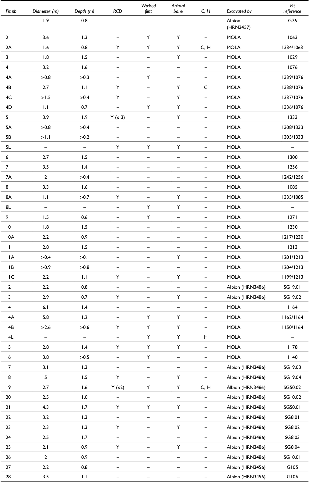


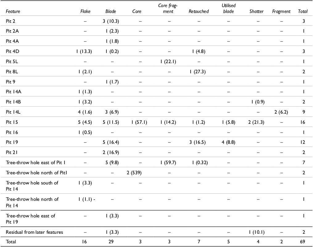
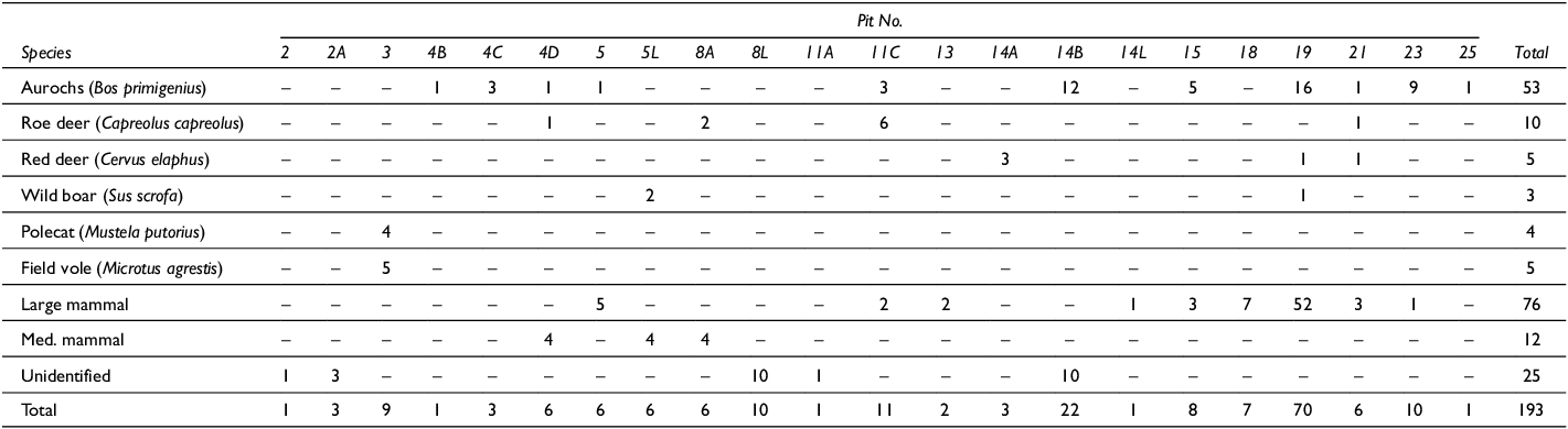
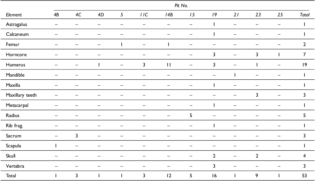
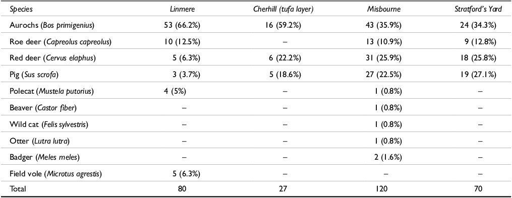


 Open access