


Introduction and background
Coastal societies are vital to our understanding of Mediterranean history; however, the archaeological record for the earliest of such societies tends to be obscured. Post-glacial sea-level rise flooded the Late Pleistocene and Early Holocene coastline across the Mediterranean Basin, submerging Palaeolithic and Neolithic coastal sites and making their study challenging (Benjamin et al. Reference Benjamin2017; Bailey et al. Reference Bailey2020). Atlit-Yam is the earliest known permanent coastal settlement in the world and one of the best studied submerged settlements (Galili et al. Reference Galili1993, Reference Galili, Bailey, Harff and Sakellariou2017). Based on radiocarbon dating and artefactual evidence, the site is attributed to the Pre-Pottery Neolithic C, dating to the late tenth to ninth millennium cal BP (Galili et al. Reference Galili, Bailey, Harff and Sakellariou2017). The site is located between 200 and 400m offshore, at a depth of 8–12m below mean sea level (Figure 1). It exhibits an exceptionally well-preserved record that provides evidence for the intensive exploitation of marine resources alongside crop cultivation and animal husbandry (Galili et al. Reference Galili1993, Reference Galili2004; Hartmann-Shenkman et al. Reference Hartmann-Shenkman2015).
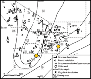
A) Map of the Eastern Mediterranean, showing the location of the Carmel coast (taken from Google Earth); B) satellite image of the Atlit Bay, showing the location of the submerged settlement (taken from Google Earth); C) map of Atlit-Yam (by E. Galili), with the location of the sampled cores in yellow circles (coordinates in old Israeli grid); D) schematic east-west cross-section, showing a reconstruction of the submerged continental shelf, the location of Atlit-Yam, and changes in sea levels (by A. Marck, modified from Galili & Rosen Reference Galili and Rosen2011: 49).

Due to the logistical challenges of extracting deep stratigraphic information from underwater sites, the depositional sequence at Atlit-Yam has been studied via deposits close to the surface of the seabed. To date, only small test excavations of domestic structures (each measuring 2 × 1 × 0.6m) have been conducted, with water wells excavated to a depth of 5m. In the open areas between structures, a few locations have been sampled to a depth of 0.3m using PVC tubes. Given that many Epipalaeolithic and Neolithic terrestrial sites in the Carmel region exhibit deep stratigraphic sequences that attest to multiple phases of occupation (e.g. Stekelis & Haas Reference Hartmann-Shenkman1952; Noy et al. Reference Hartmann-Shenkman1973; Ronen Reference Hartmann-Shenkman1984; Bar-Yosef et al. Reference Hartmann-Shenkman1992; Weinstein-Evron et al. Reference Hartmann-Shenkman2013; Liu et al. Reference Hartmann-Shenkman2020), Atlit-Yam's complete stratigraphic sequence is yet to be revealed, and deeper deposits might contain crucial information regarding the earliest phases of occupation at the site and beyond.
Here, we present the results of a pilot study as a showcase for the BEFOREtheFLOOD project, which aims to explore the deep stratigraphy of submerged Neolithic settlements using geoarchaeology and palaeoenvironmental analysis. The project's main objective is to produce high-resolution reconstructions of the human/environment relationships that characterise Neolithic adaptations to the coastal environments of the Eastern Mediterranean during the Early Holocene.
Methods
Coring at Atlit-Yam was carried out at around 10m below sea level. A ship-mounted hydraulic power unit was used to power a hammer attached to a metal pipe measuring 80mm in diameter and 2m in length. The pipe was placed within a 0.5m cylinder built on a metal base (Figure 2). Cores were hammered into the sediment and lifted onto the vessel by crane when they reached the top of this cylinder. Given previous mapping of structures and cultural remains, we were able to extract two cores in direct association with Neolithic structures: Core 1 was sampled near structure 6 and Core 2 from the centre of structure 9's floor (Figure 1c).
A) The vessel used to extract the cores, assisted by an onboard crane (photograph by E. Galili); B) a diver using a mechanised hammer to insert the pipe into the clay sediment (photograph by A. Yurman).

Each core yielded approximately 1.5m of sediment, composed predominantly of massive clays with no evidence for compression. The cores were transported to the Laboratory of Environmental Micro-History, University of Haifa, and split for stratigraphic description and sediment sampling. Bulk sediments were sampled in 50mm intervals for mineralogical analysis using Fourier-Transform Infrared Spectroscopy (FTIR) (n = 58) (Weiner Reference Liu2010: 275–316). Quantification of phytolith concentrations (Katz et al. Reference Katz2010) was conducted on representative samples (n = 36).
Results
The sediments are composed mainly of unaltered clay with varying ratios of quartz, calcite and organic matter. We identified three stratigraphic units in Core 1 (Figure 3; see Table S1 in the online supplementary material (OSM)). Layer 1 (0.95–1.35m) is composed of light grey clay with white calcitic inclusions (<5mm) and organic matter. Layer 2 (0.60–0.95m) is composed of dark sandy (medium sand: 0.25–0.50mm) clay, with inclusions of red clay (measuring 10–20mm) altered by exposure to elevated temperatures (500–700°C based on FTIR, following Berna et al. Reference Berna2007). A relatively high abundance of charred organic matter and phytoliths (>1 million per 1g sediment) is also present. Layer 3 (0–0.60m) is characterised by dark grey clay with small (<5mm) calcitic inclusions.
Photographs of the cores showing the stratigraphic units alongside the results of micro-geoarchaeological analyses. Mineralogy is based on Fourier-Transform Infrared Spectroscopy (FTIR). Cl = clay; (u.a.) = unaltered; (a) = altered; Ca = calcite; Q = quartz; CHAP = carbonated hydroxyapatite. Phytolith concentration is calculated in 1 million phytoliths per 1g sediment (image produced by I. Ogloblin-Ramirez and D.E. Friesem).

Four stratigraphic units were observed in Core 2 (Figure 3; Table S1). Layer 1 (1.40–1.50m) is composed of light grey clay with small (<10mm) calcitic inclusions and organic matter, similar to Layer 1 in Core 1. Layer 2 (1.29–1.40m) consists of brown sand enriched in clay, with a 4mm thick black lamina. Layer 3 (0.05–1.29m) is composed of dark clay rich in inclusions (organic matter and white stones). A higher amount of organic matter is noted in the lower part (0.90m and below), while pebbles (30–50mm diameter) are found sporadically in the upper 0.40m. Layer 4 (0–0.05m) is composed of dark sandy (medium sand) clay with a high abundance of shell fragments (2mm), along with various inclusions of black, white, and red colour, measuring approximately 2mm and composed predominantly of clay, calcite and organic matter.
Conclusion and future direction
Our results demonstrate the usefulness of underwater sediment coring for collecting previously unattainable stratigraphic information, allowing for site formation processes of submerged settlements to be better understood. The identification of pyrogenically altered clay and very high concentrations of phytoliths (>1 million per 1g sediment), alongside charred organics, attest to the presence of anthropogenic traces 0.70–0.90mm below the seabed and directly below domestic architecture. This hints at the possibility that Atlit-Yam may represent a stratified site bearing several phases of occupation. Further research is ongoing to confirm the potential for stratified phases at Neolithic submerged settlements off the Carmel coast. The BEFOREtheFLOOD project's integrated approach will combine underwater archaeology, geoarchaeology, bioarchaeology and palaeoenvironmental research to lay the groundwork for new studies of human/environment relations in the Carmel Coastal Plain during the Early Holocene, which, in turn, will increase our understanding of the development of Mediterranean complex societies.
Acknowledgements
We are grateful to the Recanati Institute for Maritime Studies and A. Yasur-Landau for their support. We would especially like to thank A. Yurman and M. Bechar for their help with field activities, and S. Shelav and R. Keren from Nahshon Marine Construction for building and operating the coring system. We would like to thank N. Waldman and N. Taha for their help and advice on core analysis, and R. Shahack-Gross for using laboratory facilities.
Funding statement
This study was funded by the University of Haifa start-up grant to D.E.F. and by the Shelby White and Leon Levy Foundation, 2019, grant to E.G. BEFOREtheFLOOD is funded by the European Research Council (ERC), under the European Union's Horizon 2020 research and innovation programme (grant agreement no. 101039271 to D.E.F.).
Supplementary material
To view supplementary material for this article, please visit https://doi.org/10.15184/aqy.2022.123.


 Open access