

HOW TO GET THERE:
NORTH on RT. 29 to Little Patuxent Parkway (175) (Columbia West)
Third right onto GOVENOR WARFIELD PKWY.
First traffic light right onto TWIN RIVERS RD.
Third left onto LYNX Lane
First stop sign left to end
—Promotional flier from 1982 for concert at Slayton House in Columbia, MDFootnote 1From 495 take Little River Turnpike Exit (236) away
from Annandale. Take right on Prince William Dr.
Look for “show” signs before City Hall. In Fairfax, VA. Near YMCA
—Promotional flier from 1986 for a concert at the Mantua Community Center in Fairfax, VAFootnote 2Washington, DC was littered with fliers that promoted the local hardcore punk scene during the 1980s.Footnote 3 Wade Herren, a skater turned punk enthusiast, recalls that he became acquainted with this music while skating downtown and seeing hundreds of fliers hung up on poles, walls, and bulletin boards. It is hard to ascertain where exactly in the city they were posted. One maker in 1981, either genuinely or sardonically, requested that “this flyer is not to be displayed in a public place.”Footnote 4 However, Herren remembers skating and seeing them “everywhere.”Footnote 5 These fliers—much like their counterpart, the infamous fan zines—were integral to the promotion of punk in the city. They were the visual corollary to the fast (approaching 400 bpm), yelled, short (less than 2 min), and minor mode-dominated songs of hardcore.Footnote 6 Although zines, as these homemade magazines were colloquially called, included everything from interviews with bands to original poetry to music reviews, the fliers served one specific purpose: The promotion of a hardcore punk show occurring in the area. This does not mean that fliers were entirely functional documents. Almost exclusively handmade and then printed with the help of a Xerox machine, they frequently contained art, drawings, decoupage, and bricolage—some of it political in nature, other times comedic, provocative, or merely symbolic. Yet whatever artistic license the flier maker took, all fliers needed to contain the relevant show information. The fliers someone like Herren saw posted around his city would have contained information about which bands were playing, the date of the show, entry cost, and the name and location of the performance space.
For famous punk venues in DC such as 9:30 Club, Madam's Organ, and d.c. space (stylized as such), a mention of the name or address usually sufficed; fliers did not need to provide much more information since the makers assumed that audiences would know how to get there. Yet for the punk shows that occurred in the homes, community centers, and schools of suburban Maryland and Virginia, the flier maker often included an address as well as directions. Sometimes these directions took the form of a hand-drawn map. More often, they were written in prose, much like the two examples that began this article.
Punk in DC was not just an urban phenomenon. As scholars have pointed out, punk in the nation's capital was made and listened to by white, middle class, suburban youth. The scene was not so much centered around DC as it was centered around the DC/Maryland/Virginia metropolitan area, also known as the “DMV.” Early releases of Scream's Still Screaming (1983) show the suburbs’ importance to the band since they wrote “bXr” on the album's cover art, a reference to Bailey's Crossroads, a suburb in Fairfax County, Virginia, where bandmembers Pete and Franz Stahl were from.Footnote 7 Punk shows promoted on fliers not only occurred in the city proper but also in the geography that punk musicians and audience members alike knew best.
How did flier makers (who rarely signed their work, by the way) expect attendees to get to the suburbs of the DMV?Footnote 8 All their written directions must begin somewhere—and that somewhere reveals a lot about the spatial logics of the DC punk scene. Although the directions were clear about the final destination (the venue), flier makers had to make assumptions about where an appropriate place to begin their instructions would be. In an era before global positioning satellite could pinpoint a user's exact location, flier designers could begin their directions from anywhere. They could direct audiences to commence their travel to suburban punk shows by starting just few feet from the venue, along a main road adjacent to the venue, from the highway, or even from a different city. These direction-givers made decisions about their real or imagined audience and acted accordingly, beginning their directions with a geographical reference that a group of insiders would all know.
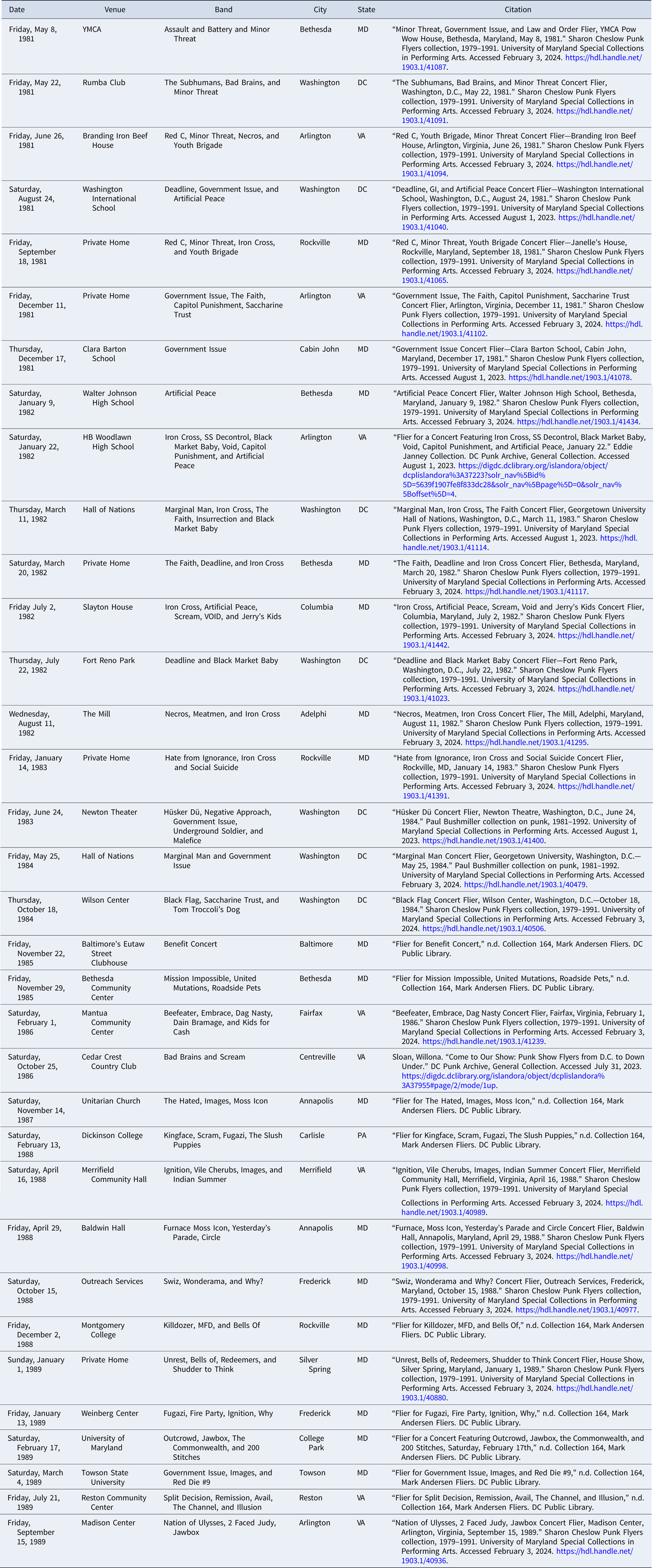
For this article, I examined hundreds of fliers contained within the Sharon Cheslow, Paul Bushmiller, Robbie White, Eddie Janney, and Mark Andersen collections at the University of Maryland and DC Public Library. In them are dozens of fliers that contain directions. Sometimes the directions are not overly specific: “near Union Station,” instructs one flier for a Teen Idles show taking place in 1980 at Reek's.Footnote 9 Sometimes these fliers are for shows in Richmond, Virginia or Baltimore, Maryland and the directions begin in those cities.Footnote 10 Although such directions are instructive and testify to the DC punk's community inclusive sense of geography, I am more interested in the local references specific to the DMV: The local streets, local neighborhoods, and local landmarks that articulate clear points of departure.
With this metric in mind, I found thirty-four fliers that contained directions—written either in prose or drawn as a map—that began in DC, were made during the 1980s, and lent themselves to be easily digitized and spatially analyzed. There were several duplicates that I did not consider. For instance, multiple fliers with directions were made to take people to HB Woodlawn School over the course of the 1980s. However, the directions were mostly the same. This means that readers should view Appendix A, which consists of a table including the fliers analyzed, as thirty-four distinctive “routes” as opposed to a comprehensive list of where punk shows were held.
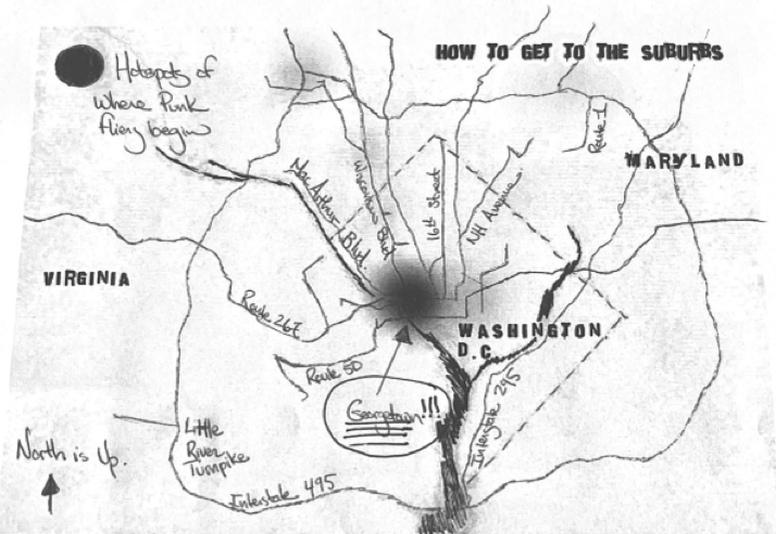
What kind of audiences living in the area get targeted once these directions get analyzed? Figure 1 is a hotspot analysis I made of the starting points of these thirty-four routes, showing that, by focusing on the language of these directions, the unofficial and unassumed starting location for many directions to suburban venues is typically from the suburbs themselves or in and around Georgetown, an upscale neighborhood in the capital. Given what scholars already know about the DC punk scene, this might appear self-evident. These are fliers made by, presumably, suburban white punk fans listening to bands comprised mostly of suburban white musicians playing music that takes place often in suburban white geographies. Understandably, the directions would keep this audience in mind.
Map showing the 34 routes with a hotspot analysis created in QGIS of starting points. Created by author.
However, that such starting points are merely assumed and unspoken recalls the work of Sara Ahmed and George Lipsitz on the unmarked nature of whiteness. “Whiteness is invisible and unmarked, as the absent center against which others appear as points of deviation,” Ahmed writes, while “whiteness never has to speak its name, never has to acknowledge its role as an organizing principle in social and cultural relations” according to Lipsitz.Footnote 11 Here, the suburbs and affluent neighborhoods, themselves overwhelmingly white, operate similarly. Both geographies are unspoken, unmarked, and merely assumed to be the starting point for punk audiences. Perhaps without even realizing it, the racial and economic privilege that many punk musicians grew up inhabiting courses through their promotional fliers. In a segregated city such as DC, something so seemingly apolitical, incidental, and ancillary as the giving of directions can reinforce and bolster spatial inequities. “You're invited,” fliers from the 1980s basically stated; but “you're not.”
The Spatial Logics of DC's Punk Scene
As an introduction to the type of methodology this article employs, take the directions for a concert by Red C, Government Issue, and Minor Threat that occurred in 1981 as an example. It provides an opportunity to discuss how the starting point of directions creates an audience of insiders and outsiders. The show in question occurred at the Imperial 400 Motor Lodge, located on 2201 Arlington Boulevard in Arlington, Virginia and the instructions on the flier merely instruct attendees to take “Route 50 in VA towards Falls Church.”Footnote 12 Although Route 50 is a major west–east path along the United States Numbered Highway System that stretches 3,000 miles from Sacramento, California to Ocean City, Maryland, the directions simply say “towards Falls Church.” Noticeably, these instructions do not give cardinal directions. They do not instruct attendees to take Route 50 “west” or Route 50 “east.” This decision does not discriminate according to directions of travel and instead allows for the possibility of people living east or west of the venue to get to Arlington with ease; all they have to do is go towards “Falls Church.” In just these seven words, several audiences are targeted: Those that are familiar with Route 50 and would be coming from either Route 50 East (i.e., from western areas like Seven Corners, Virginia) or Route 50 West (i.e., via Constitution Avenue in DC) who know where Falls Church is in the first place.
Now see what difference adding a couple of lines at the beginning makes: “Take Florida Avenue to Route 50 in VA towards Falls Church.” The simple introduction of “Florida Avenue,” a major thoroughfare in Northwest and Northeast DC, as a reference changes the entire prospective audience. Suddenly, the instructions no longer invite attendees coming from the city's western suburbs and instead welcome a whole new demographic centered in the city proper, specifically around Gallaudet University and the neighborhoods of Eckington and Trinidad. These audiences would then take Florida Avenue to New York Avenue where they can pick up Route 50. Such a simple change of references makes a world of difference. A city like Falls Church, Virginia in 1980 was 93 percent white with a median household income of $24,517.Footnote 13 Contrast this to Census Tract 85 in DC, which lies just south of Gallaudet and borders Florida Avenue at 4th Street.Footnote 14 The demographics of residents living here were 3 percent white and the median income was $14,681. With every omission and inclusion of points of reference within these directions, some doors open while others close. Some audiences get targeted; others get ignored.
How directions get written matter in a city such as DC, which, thanks to urban renewal policies, inefficient public housing, the development of the interstate system, zoning laws, restrictive covenants, and redlining, was economically and socially segregated during the 1980s.Footnote 15 Social scientists typically use an index to identify distribution of populations within a locale: 0 percent is a random distribution of white and Black peoples across a city whereas 100 percent is total apartheid. According to census data from the 1980s, DC's residential segregation index was around 76 percent, meaning that 76 percent of either demographic would need to relocate to achieve a uniform distribution.Footnote 16 Educational segregation followed this trend, where the index was around 60 percent in 1980.Footnote 17 Ian MacKaye, member of the Teen Idles, Minor Threat, Fugazi, co-founder of Dischord Records, and all around DC punk figurehead, witnessed this educational segregation firsthand. During his teen years, MacKaye attended Woodrow Wilson High School in the city's Tenleytown neighborhood.Footnote 18 In years prior, the school was about 99 percent white. By 1980, around the time MacKaye was attending, it had shifted to 17 percent white.Footnote 19 The district's public schools in general were overwhelmingly Black and in 1974, white enrollment in the school system was just 3 percent.Footnote 20 Economic inequality followed alongside such residential and educational segregation. In general, the city's poorest sections were situated east of the Anacostia River in Southeast DC whereas the more affluent and high-income households were in the Northwest.Footnote 21
Although the city itself was segregated, an urban/suburban divide emerged as well. Beginning in the 1950s and 1960s, federal housing policies—to say nothing of an urban uprising that shocked DC in 1968—helped aid “white flight” to the suburbs. In 1950, around 500,000 white and 280,000 Black citizens lived in DC. By 1970, however, those numbers had basically switched, with the white population relocating to western and northern suburbs like Arlington, Fairfax, and Bethesda whereas Black residents moved in from Virginia and the Carolinas.Footnote 22 The differences between the capital and suburbs had become extreme. Although the Black middle class moved to the suburbs as well, notably in Prince George's County, much of the suburbs were highly uniform. In the 1960s, the city had a 59 percent nonwhite population whereas the suburban population was 94 percent white, reflecting trends across the country.Footnote 23 By 1993, 86 percent of suburban white residents still lived in places with a Black population below 1 percent.Footnote 24 Such segregation manifested itself economically as well. In 1960, more than a fourth of city residents but only a tenth of suburban residents were in the lowest income group.Footnote 25
Punk musicians recognized such racial, economic, and spatial divisions within their community. Despite segregation, the large number of nonwhite residents living in DC meant that the scene was comprised of integrated or even all Black punk bands. Groups like The Enzymes, Scream, Void, and Red C all had one Black member and Bad Brains were a notable example of an entirely Black group. In 1985, punk members organized Positive Force DC, an activist organization that hosted and sponsored benefit concerts across the city, directing much of their attention to South Africa's apartheid state.Footnote 26 Punk musicians were also outwardly supportive of go-go, a style of music performed almost exclusively in Washington, DC, by African Americans, and other forms of Black cultural production.Footnote 27 One could correctly get the impression that white punk musicians were actively trying to counteract the racial and economic injustices present in the city.
Not that such attempts at integration and cross-cultural exchange always succeeded. When Minor Threat and Big Boys, a punk band from Austin, Texas, got together with Trouble Funk, a prominent local go-go band, to play a joint show at DC's Lansburgh Center in 1983, it was a relative disaster. Lyle Preslar, Minor Threat's guitarist, recalled that “there were two audiences there. And the white kids got into Trouble Funk, but the Black kids didn't understand the Big Boys and us at all, they couldn't relate to it.”Footnote 28 Similarly, Dug Birdzell, member of Beefeater, noted that “the DC scene was more integrated than other scenes, but it was integrated like a black and white cookie.”Footnote 29 Preslar also noted, on the back of the Lansburgh Center show, “while there was some integration, if you will, I'd still say it's pretty small.”Footnote 30
More to the point: White punk musicians were cognizant and critical of their city's inequality, but certainly thought they did little to contribute to it. In interviews with scholar Evan Rapport, white punk musicians from northern backgrounds remember segregation as “just the way it was,” rather than a result of intentional discrimination.Footnote 31 Minor Threat's 1984 song, “Guilty of Being White,” captures this outlook perfectly. In it, singer MacKaye abdicated any responsibility in racial segregation and discrimination, stating that “I'm sorry/for something that I didn't do/Lynched somebody/But I don't know who/You blame me for slavery/a hundred years before I was born.”Footnote 32 As Shayna Maskell notes in their study of the DC punk scene, despite MacKaye's attempts to be antiracist, the song still “ignores the cultural and practical privileges that white bodies possess.”Footnote 33
Despite their attempts to abdicate responsibility, an analysis of directions and maps circulating within the DC punk scene shows how punks actively upheld the city's segregated geography. Such contradictions are not unique to the city's history of punk. As scholar Maxwell Woods notes, although they were critical of consumerism and bourgeois economic value systems, DC punks simultaneously contributed to the gentrification of DC by conceiving the city as an empty and decayed locale perfect for masculine frontiersmen like themselves.Footnote 34 Maskell makes a similar comment, noting how “the suburbs were the figurative enemy and ally, rolled into one.”Footnote 35 Rapport echoes this point, remarking that “members of [punk scenes] tend to replicate the broader social environments in which they live, even if they outwardly reject them.”Footnote 36 This article echoes such claims, showing how punk musicians both reinforced spatial segregation while being critical of it.
How to Get to the Suburbs
A flier for a show featuring Outcrowd, Jawbox, the Commonwealth, and 200 Stitches that took place at the University of Maryland, College Park in 1989, shows how punk promotors assumed that audiences going to College Park would already be coming from the suburbs. “Take Beltway to Route 1 South. Take right into main entrance (campus drive). Go about a mile (3 stop signs). On right is The Student Union,” the directions instruct.Footnote 37
Completed in 1961, I-495, colloquially called the Beltway, was constructed in the shape of a ring. “Inside” the Beltway lies both DC and, either in whole or in part, the inner suburbs of Arlington, Fairfax, Montgomery, and Prince George's County. “Outside” the beltway lies outer suburbs like Tyson's Corner and Rockville. Although it was originally intended to facilitate military travel in the event of an emergency that occurred within the nation's capital, it quickly became a local artery that contributed to the growth and expansion of inner and outer suburbs.
Its construction was also fiercely contested. In 1959, three years after the passage of the Federal-Aid Highway Act, the National Capital Planning Commission released its Mass Transportation Plan: A plan that called for 329 miles of freeways in and around DC.Footnote 38 As scholar Kristy Maddux notes, resistance to the idea was led by two local groups: The Committee of 100 on the Federal City (a group of white elites who wanted to protect Pierre L'Enfant's original urban plan of the district) and the Emergency Committee on the Transportation Crisis (a multi-racial group with roots in Black Nationalism and local activism).Footnote 39 Between 1968 and 1972, the latter group staged more than seventy-five protests during which they characterized the freeway program as an example of coloniality that stripped the urban fabric of its life. Group members also printed out fliers that recounted the undemocratic implementation of freeway construction and adopted a slogan that called freeways a “white man's road through Black man's home”—a slogan that referred to the proposed destruction of Brookland, a neighborhood in Northeast DC with a high rate of Black homeownership.Footnote 40 Their protests worked.
Thanks to the work of the Committee of 100 and the Emergency Committee on the Transportation Crisis, the proposed highways—which were supposed to traverse a new “Three Sisters Bridge,” create an “Inner Loop” in Downtown, and then proceed up through Northeast DC—were never constructed. Instead, what was built were several auxiliary interchanges like I-395 and I-695 along I-95, which instead of running through downtown was diverted. In addition to these smaller interchanges, I-295 was built along the Anacostia River in Southeast DC before it linked up with the encircling I-495.Footnote 41
Despite these small victories, as Brett Williams notes in a history of environmental racism in Southeast DC, “the highways demolished poor neighborhoods, quarantining poor people from trendy Capitol Hill and from the Anacostia River on the east.” The Anacostia Freeway (i.e., I-295) “went up the same year as the Berlin Wall. It meant about the same thing,” a local musician recalled to Williams.Footnote 42 For many, the interstate system was an object of scorn.
These interstates did not merely destroy some communities. They bolstered others, and the areas that I-495 intersects are not just some of the richest and whitest counties in Virginia or Maryland. They are some of the richest and whitest in the country. Of the four counties that I-495 passes through—Prince George's, Montgomery, Fairfax, and Alexandria—Fairfax was the country's twentieth richest in the 1980 census with a median income of $25,810. Prince George's was seventy-ninth ($22,935), whereas Alexandria was 136th ($21,016). Home prices were also high along the Beltway. Montgomery ranked thirteenth in the country with the median home price costing $97,400. Fairfax was fifteenth ($95,200) and Alexandria was twenty-second ($92,800).Footnote 43 All the while, cities like Bethesda, Silver Spring, Columbia, Alexandria, and Arlington were anywhere from just 2 to 22.3 percent Black.Footnote 44 Although Prince George's County, as a whole was rather integrated and possessed a thriving Black middle class, College Park was still 82 percent white according to the 1990 census, which was taken just one year after the Outcrowd gig occurred.Footnote 45 Contrast such data with data from the census tracts located either side of the Anacostia River in Washington, DC where non-white residents were 92 percent of the population. Incomes ($14,000) and home prices ($60,000) in Southeast DC were both about 60 percent the income of suburban counties.Footnote 46 But this is not where this flier creator assumed residents would come from. Instead, the concert promoter wanted (or expected) attendees to begin in these suburbs, on the outer edge of DC, and alongside the interstate that helped fuel white flight out of the city.Footnote 47
Not all directions to suburban venues required attendees to begin in the suburbs, though. Many of them required that prospective audiences begin either in or around Georgetown, one of DC's most affluent neighborhoods. These starting points were often unspoken. Take the directions to a show featuring Deadline, Government Issue, and Artificial Peace that took place at the Washington International School at 3100 Macomb Street NW in 1981 as an example.Footnote 48 These directions begin by instructing attendees to “Take Wisconsin Avenue.” The promoter then writes “turn right on Macomb St. past cathedral. Go down 3 blocks almost to Conn. Ave. to iron fences of Wash. Int.” Wisconsin Avenue is a major north–south thoroughfare on the west side of DC that begins just south of downtown Georgetown, where it intersects with K Street, and continues north through Northwest DC. It passes by Observatory Circle, the Washington National Cathedral, and Tenleytown. It then continues into Bethesda, Maryland, where it becomes Route 355. By instructing audience members to “turn right on Macomb St.,” the instructions do not assume attendees will begin north of the school but instead south of it, somewhere between Macomb and K. Streets.
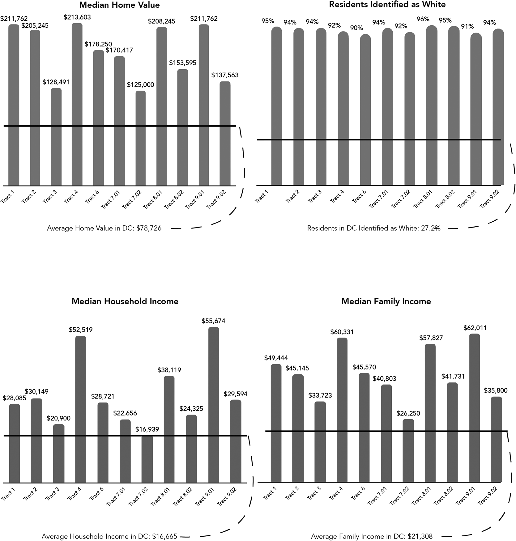
According to the instructions, attendees could start in Georgetown, the terminus of Wisconsin Avenue, or anywhere along Wisconsin Avenue south of the Washington International School. During the 1980s, the neighborhoods that bordered the avenue in this part of the city were some of the wealthiest and whitest. After it leaves Georgetown, but before Macomb Street, Wisconsin passes through four census tracts: 4, 6, 7.01, and 7.02. All four of them were at least 91 percent white. All four of them ranked in the top 20 percent of tracts in the city for median home price and Tract 4 came in second. Three of the four of these census tracts ranked in the top 18 percent in median family income and median household income, with the only outlier being Tract 7.02, a small tract centered around Calvert Street, Davis Place, and Tunlaw Road west of Wisconsin. It ranked sixty-ninth and forty-fifth in the nation in the last two categories.
Another show featuring Government Issue, this time at the Clara Barton School/Clara Barton Community Center in Cabin John, Maryland, also relies on directions that begin roughly in Georgetown.Footnote 49 For this show, which took place in 1981, the poster simply states “on McArthur Blvd, first right after the one way bridge.” MacArthur Boulevard's southern terminus lies just west of Glover Archbold Park where it intersects with Canal Road (which then becomes M Street). Heading northwest, MacArthur Boulevard goes along the Potomac River through Foxhall Village, Berkley, and Palisades. Once in Maryland, it continues through Brookmont, Glen Echoes, and past the “one way bridge,” also known as the Union Arch Bridge or Cabin John Bridge, before ending at the Chesapeake and Ohio Canal National Historical Park. By instructing attendees to take the “first right,” the flier assumes once again that attendees will be coming south of the venue.
According to the instructions, attendees could start just west of Georgetown on the other side of Glover Archbold Park where the terminus of MacArthur Boulevard was; or they could begin, technically, anywhere along MacArthur that was south of the Clara Barton School. No surprise, according to the 1980 census, the neighborhoods that border MacArthur in this part of the city are also some of the wealthiest and whitest. Between Georgetown and Cabin John, MacArthur passes through four tracts within DC: 8.01, 8.02, 9.01, and 9.02. All four of these tracts were at least 91 percent white. They all were within the top 15 percent in median home value, median household income, and median family income. Tract 9.01, which borders MacArthur Boulevard to the east at Palisades, ranked first and third in median household and median family income in the entire city.Footnote 50
A final example makes the centrality of Georgetown within the DC punk scene clear. To go to a show that occurred in 1982 in Arlington by SS Decontrol and Black Market Baby at HB Woodlawn School on 4100 Vacation Lane in Arlington, Virginia.Footnote 51 “From Georgetown,” the instructions state outright, “cross Key Bridge into VA.”Footnote 52 Whether, overtly, such as in this example, or indirectly, via beginning the directions with instructions to take MacArthur Boulevard or Wisconsin Avenue and head north, the directions all begin roughly in the same neighborhood: Georgetown.
That Georgetown exists as the unspoken starting point of so many directions should come as no surprise given its importance to the scene.Footnote 53 Students at Georgetown University ran WGTB, a university-affiliated radio show, where they played early New York punk during the 1970s.Footnote 54 While a student in Georgetown's Foreign Service Program, Robert Goldstein formed The Urban Verbs, an early DC punk group.Footnote 55 Ian MacKaye remembers seeing The Cramps play at the Hall of Nations at Georgetown University—an experience so foundational that he shaved his hair immediately after (to mimic the style of fellow punk fans and musicians).Footnote 56 The surrounding neighborhood itself was also a stomping ground for punk musicians. Brian Baker and Lyle Preslar, members of Minor Threat, attended the Georgetown Day School.Footnote 57 Mackaye worked at the Georgetown Theater and the neighborhood's Häagen-Dazs branch. His brother, Alec, a guitarist and vocalist in the Untouchables, recalls “we were always in Georgetown,” often hanging around the intersections of Wisconsin Avenue and M Street where they frequented the Penguin Theater, Ikaros (a Greek Restaurant), record stores like Record and Tape Ltd. and Orpheus Records, and the fast food chain Roy Rogers.Footnote 58 A flier for a show at Hall of Nations pointed out that the venue was “6 blocks west of Roy Rogers in Georgetown.”Footnote 59
Although Georgetown was a hotbed for DC punks, it was also home to the city's most affluent. Shortly after its foundation in 1791, the neighborhood became home to a few prosperous white residents who built mansions like Dumbarton Oaks and Tudor Place in the area. After the Civil War, newly freed enslaved people moved to the neighborhood primarily to work in the waterfront industries. While the Potomac River giveth, it also taketh away, flooding the neighborhood several times around the turn of the twentieth century, destroying the local economy and helping to create one of the worst slums in the city. An early wave of gentrification occurred as the Black and Irish working class who called the region home were gradually displaced by New Deal-era federal workers. These new residents not only renovated the neighborhood but, aided by racial covenants and Georgetown's new status as a historic district (achieved in 1950), drove up property taxes and housing prices.Footnote 60
By the 1980s, the neighborhood became a symbol of Washington, DC's bourgeoisie culture. Despite the diversity of Georgetown—a place where Marines, punks, and university students all congregated—the neighborhood nevertheless gained a reputation as the city's “preppy playground.”Footnote 61 Georgetown University acted as a “mostly white enclave in a Black city,” as one group of historians noted.Footnote 62 Boutique shops lined the streets and some, such as Commander Salamander, even began to sell “punk fashion.”Footnote 63 As Aaron Goldfarb notes, the bar scene in Georgetown during the 1980s was “a melting pot of fledgling lawyers, bankers and politicos [who] still enjoyed dressing up in boat shoes, blue blazers and Brooks Brothers button-downs.”Footnote 64 Until 1986, the drinking age in DC was only 18 and, on any given Saturday night in 1982, the DC Department of Transportation estimated about 10,000 cars and 6,000 pedestrians traveled through the intersection of Wisconsin Avenue and M Street.Footnote 65 Films like St. Elmo's Fire (1985) dramatized Georgetown bars like The Tombs and Hoya alumni have created vibrant websites dedicated to preserving oral histories and photographs of the “preppy” and “bougie” neighborhood bar scene.Footnote 66
The 1980 census makes the racial and economic exclusivity of Georgetown and the three tracts that comprised the neighborhood—tract 1, tract 2, and tract 3—apparent. Figure 2 shows that, during that census, these three tracts were all around 94 percent white. They also had the third, sixth, and fifth highest percentage of white residents, respectively. Tract 1 had the third highest median home value. With respect to highest median household income and median family income, out of all 182 tracts in Washington, DC, tracts 1, 2, and 3 all scored within the top 20 percent. Tract 2 ranked second.Footnote 67 Whether by starting in the suburbs or in and around Georgetown, directions on punk fliers asked audiences to begin in the region's most affluent and whitest regions.
Four charts showing the status of the census tracts where Wisconsin Avenue and MacArthur Boulevard intersect. Chart created by author.
The way the directions handle (or don't handle) public transportation also show preference for certain modes of travel and certain demographics. To be clear, some fliers, particularly during the late 1980s, gave station names such as Foggy Bottom, Capitol South, Columbia Heights, and U-Street as references, demonstrating that attendees would often take advantage of the Washington Metro that opened in 1976.Footnote 68 Although several suburbanites objected to the construction of the Washington Metro, the transit authority's original Metro plan included “the promotion of orderly growth in suburban areas along well defined and carefully planned lines” as one of its functions.Footnote 69 For instance, the stations at Shady Grove, Rockville, Twinbrook, and North Bethesda all opened in 1983, allowing residents of Maryland's Montgomery County easy access along the Red Line.
In contrast, DC-area fliers rarely included directions for travel via bus, a decision that largely could be attributed to perceptions of the city's Metrobus system. As Zachary M. Schrag notes in his history of the Washington Metro, “because buses are slow and cheap, they tend to attract people for whom money is more valuable than time, which in practice means poorly paid workers or people without jobs.”Footnote 70 In 1977, one local politician predicted the emergence of a “largely segregated transit system, with the poor and Black squeezed into sweltering buses while the rich and white use the fancy new suburban railroad.”Footnote 71 The Washington Metropolitan Area Transit Authority even recognized “the potential creation of at least the image of a two class system, Metrorail for the rich and Metrobus for the poor.”Footnote 72
Although punk fliers throughout the 1980s encouraged attendees to arrive to a concert at George Washington University via the newly constructed rail lines (Foggy Bottom on the Orange, Blue, or Silver Lines, for instance), they rarely provided the equivalent bus lines that would take audiences to the same location (the Pennsylvania Avenue Lines or the Wisconsin Avenue Lines, for instance). Of the thirty-four fliers with geographic information that I analyzed, only a few included directions by bus: Two concerts at the Wilson Center. One flier, from 1984, promoted a Black Flag performance, and instructed attendees to take a “40 or 42 Bus marked ‘Mt. Pleasant’ to 16th and Irving, or any 14th or 16th Street Bus.” The other was from 1988 for a show featuring King Face, False Prophets, and Fugazi and contained similar instructions.Footnote 73
There was probably a good reason why fliers for the Wilson Center, located at the intersection of 15th Street and Irving Street in Northwest DC, occasionally contained bus directions. Compared to the census tracts surrounding Wisconsin Avenue, the census tracts surrounding Columbia Avenue in the Adams Morgan neighborhood, where the 40 and 42 bus shuttles between Dupont Circle and the Mt. Pleasant terminus, contained a higher proportion of non-white residents in 1980 and 1990: 30 percent non-white in the neighborhoods closer to Dupont Circle and up to 70 percent in Mt. Pleasant and Lanier Heights.Footnote 74 It also contained a low rate of vehicle ownership: A little less than half of all households in the area owned no vehicles and thus relied on public transportation, walking, or other modes of transit.Footnote 75
In addition to the area's low rate of vehicle ownership, Adams Morgan and the adjacent Columbia Heights and Mt. Pleasant neighborhoods were becoming increasingly Hispanic. In the late 1980s, when the King Face show took place, some census tracts in the surrounding area would have been around 20 percent Hispanic.Footnote 76 As historian Mike Amezcua writes, the DC punk scene “relied on the local Latinx community” and as early as the mid-1960s, Latinx community leaders had turned “El Centro Wilson” into a base for “community action, organizing rallies and protests on a range of issues including immigrant worker rights and antidiscrimination campaigns in city hiring.”Footnote 77 By the 1980s, amidst President Ronald Reagan's military aggression in Central America, an increasing number of immigrants took refuge in DC, frequently organized themselves in the Wilson Center, and created a “monument to resisting the politics that ascended with Reagan in the ‘80s.”Footnote 78 As several fliers demonstrate, many punk concerts there doubled as protests and benefit concerts. Proceeds went to the Washington Peace Center, Big Mountain Support Group for Indigenous Rights, and the “invisible Americans: illegal immigrants.”Footnote 79 It's a testament to the punk scene's interest in broad coalition building that fliers such as those for the Wilson Center existed. These were fliers that highlighted concerns specific to Central Americans, promoted relevant events in Hispanic neighborhoods, and told its residents—many of whom did not have a car—how to arrive to such events via bus.
Yet, quantitatively, the dearth of fliers that mimic this approach, compared to ones that privilege automobile or subway travel, is telling and speaks to the limits of the punk community's inclusive geography. Refer to the University of Maryland Special Collection's “Persistent Vision” exhibition to see just how automobile-centric the punk community was. The exhibit, which digitized forty-eight fliers that were made in 1981, contains twelve fliers with directions to punk shows.Footnote 80 None of them were made specifically for public transportation in mind and, except for the fliers that simply directed attendees to specific intersections, all of them are written exclusively for automobile travel. Compared to bus riders, audiences coming in cars were more heavily targeted. In this way, punk fliers reinforced segregation not via location (i.e., by taking I-495 or by coming from Georgetown) but instead by not typically including opportunities for bus travel, a mode of transit that coded as nonwhite and poor.Footnote 81
West is up
A final example helps summarize how punk musicians, audiences, and flier designers were conceiving of the geography around them. On October 25, 1986, Bad Brains had a gig at Cedar Crest Country Club in Centreville, Virginia. There, they would perform alongside Scream at a “2 Day Skate Jam” that took place at the club's famous half-pipe skateboarding ramp.Footnote 82 Like many punk shows that took place in the DMV, this concert was promoted on a handmade flier. It provided the date of the jam and promoted the bands performing in big bubble letters. It included a photo of Scream xeroxed on the page. It let prospective attendees know that, additionally, a band from Blacksburg, Virginia called Your Mom was playing. The flier provided the prospective demographics of attendees (“All Ages. All Types.”) as well as the cost to enter ($5.00). Then, of course, it provided the location (“At: Centreville, VA.'s Cedar Crest Ramp.)Footnote 83
Like shows at the University of Maryland, the Washington International School, the Clara Barton School, and the HB Woodlawn School, this show at Cedar Crest required some additional information. Centreville lies about twenty-five miles west of the capital. Regular attendees of the country club's skate ramp said it was in the middle of “Deliverance country,” referencing the 1972 thriller starring John Voigt and Burt Reynolds that takes place in the remote Georgia wilderness. To get to Cedar Crest you had to pass over a “muddy road, bumpy as all hell.” Skaters, bands, and audience members often didn't know if they were going in the right direction. “You had to know where you were going or be with someone who knew where they were going,” one regular visitor recalled.Footnote 84
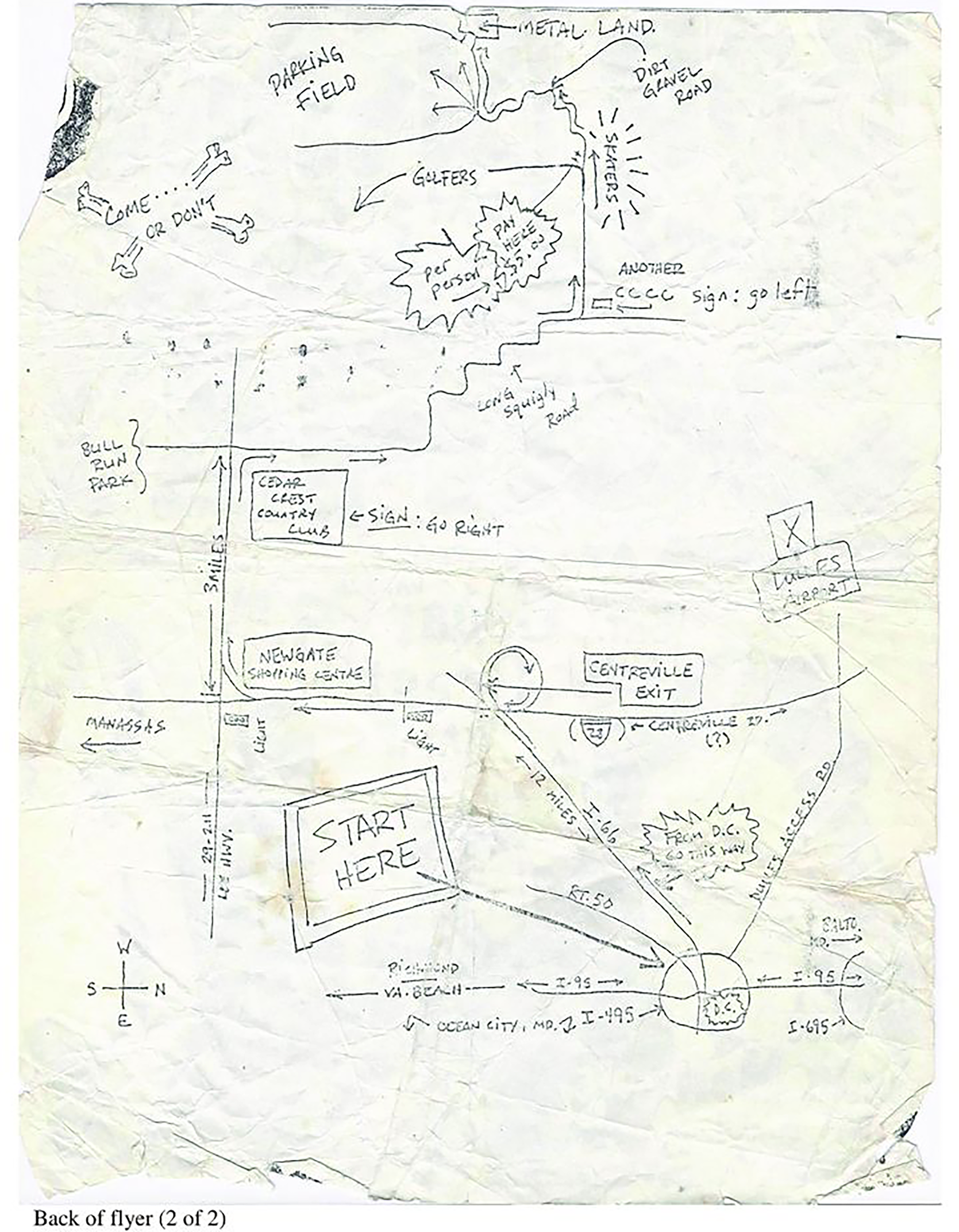
Fortunately, this flier designer had it covered. Instead of including directions written in prose, however, they included a hand-drawn map with an arrow pointing roughly to DC on the backside of the flier. To get to the Bad Brains/Scream/Your Mom triple billing, you had to “start here.” The directions continued: “From DC, go this way.” Take I-66 for twelve miles until you hit the Centreville Exit. Exit onto Centreville Road and head south toward Manassas. Pass by one light. (I am now translating the map into prose.) At the second light, where the Newgate Shopping Center is, take a right. Go west for three miles on Lee Highway/US 29/US 211 until you see the sign for Cedar Crest Country Club. Make a right and continue along a “long squiggly road” (the flier designer's words) until you see another sign for the country club. Make a left at the sign. At the junction that separates the turn off for “golfers” from “skaters” (that the author highlights with halos drawn around the text), pay the entrance fee, then continue along the “dirt gravel road.” There will be a parking field next to “metal land,” the nickname given to the half pipe renowned for its steel bottom that allowed skaters maximum speed.Footnote 85
This map was elaborate. As Figure 3 shows, it included some extra contextual information for attendees arriving from Richmond, Virginia Beach, or Baltimore via I-95. It plotted the location of Dulles Airport. The map maker also circumscribed DC in I-495 and included a line designating Route 50 for people coming from Arlington or the other Virginia suburbs. The map maker could have pursued a career in cartography if they wanted.
Map of how to get to Cedar Crest Country Club. Author unknown. Provenance of Mark Andersen. Source: Willona Sloan, “Come to Our Show: Punk Show Flyers from D.C. to down Under,” DC Punk Archive, General Collection, accessed July 31, 2023, https://digdc.dclibrary.org/islandora/object/dcplislandora%3A37955#page/2/mode/1up.
This map highlights two themes prevalent in the other fliers. First and foremost, the maps and directions included in punk fliers are for residents of DC. Recall where this punk promotor/amateur cartographer wants people to begin their journey. “Start here,” the directions demand—not in Manassas, Arlington, or Richmond. No. “From DC,” the author instead writes. This interest in highlighting DC—all sixty-eight square miles of it—is echoed by punk musicians themselves. Gray Matter's “Oscars Eye” and the title of the album it was on, Food for Thought (1990), were both named after famous venues within the capital. Similarly, Rites of Spring's “Hain's Point” (1985) honored the scenic southern outpost on Roosevelt Island.Footnote 86
However, the language used, and the directions given, are not really for all of DC's 630,000 residents that called the city home in 1980. Instead, these instructions, given either in prose or visually via a map, privilege the geography of some areas over others. Refer one last time to the Cedar Crest Country Club flier. The map on the back, plotted in portrait orientation, takes a unique approach to its layout. In this map, west is up. It is a decision that should not be dismissed.Footnote 87 As several scholars of religion, history, and cartography note, a map's orientation is often a symbolic act. Medieval Christians generally put east at the top of their maps, corresponding to the importance of eastern travel in the Old Testament. Early Muslims tended to put south at the top of their map. Since their conquests typically occurred north (into Spain, for instance), by placing themselves at the top of the map, these Muslim cartographers visually presided over their conquered subjects to the north who were located below them on the page.Footnote 88
That the Cedar Crest Country Club map is oriented west is unique because, for several historical, economic, imperialistic, and cultural reasons, maps in the United States during the twentieth century almost always put north at the top.Footnote 89 Of course, cartographers can reorient their map for less symbolic reasons, namely to save space. However, if this were the case, the flier creator could have easily turned their page ninety degrees and constructed a northern oriented map from landscape orientation. It would have been easier for prospective “2 Day Skate Jam” attendees to read. As several researchers have noted, the fact that “north is up” has been a cartographic standard beginning in the sixteenth century has led to individuals in the West possessing a clear sense of north. The “maps in our head,” as a group of psychological scientists point out, is “oriented north.”Footnote 90 By choosing to not orient their map north, the Cedar Crest Country map maker, therefore, wanted their attendees to struggle. Open a Rand McNally paper map or go visit Google Maps. North is up; but here it is not. West is up. The cartographer wanted attendees to see the map from an untraditional point of view. They wanted to draw attention to the space west of DC; and what exactly lies west of DC? The heavily populated Virginia suburbs like Arlington, Fairfax, and Falls Church. In other words, the suburbs are up.
Historians of cartography have recently noted how everyday individuals design maps as one of many ways to define themselves. Catherine Tatiana Dunlop, for instance, argues that late nineteenth century mapmaking did not exist just in the gilded rooms of palaces and military headquarters but also in schoolhouses where elementary students constructed their own maps. Mapmaking existed in hiking associations where German and French groups created hiking maps that helped define the Vosges Mountains in national ways; and it existed in village communities who published detailed plans of settlements and surrounding farmlands to reinforce notions of Heimat and la petite patrie.Footnote 91 This “popular cartography” can be seen in the United States as well, as historian Susan Schulten notes. During the early nineteenth century, schoolgirls were frequently taught cartography, and the creation of a national map, in specific, was often a demonstration of civic pride, a statement of national coherence, and even a way for students to connect to fellow Americans whom they would never meet.Footnote 92 Some 150 years later, punk musicians relied on maps and directions to likewise imagine a world and construct their identity.
What an analysis of maps and directions in DC punk fliers shows is that the worldview created by such geographies was often at odds with the music that punk musicians made. As Shayna Maskell notes, many punks derided their suburban lifestyles and Georgetown's status as white and upper class. In Scream's “U. Suck A./We're Fed Up” from their 1983 debut album, Still Screaming, lead singer Peter Stahl takes shots at suburban life. “Oh, say can you see/Through intellectual poverty/At your suburban luxuries/ From slimy sea to sea,” he sings, riffing on the lyrics to the national anthem and “America the Beautiful” to comment on economic excess.Footnote 93 Void, a band from Columbia, Maryland released a straightforward song in the early 1980s: “Suburbs Suck.” Similarly, in Government Issue's “Fashionite,” from their 1981 Legless Bull E.P., the lyrics mock Georgetown: “Shops in all the high class stores/All you are is high class whores/ Georgetown's where you spend your time/Think you're cool but you're just slime.”Footnote 94 Furthermore, Evan Rapport speculates that the antidrug and antialcohol “straight edge” movement that coursed through the punk scene in the 1980s, spurned by Minor Threat's song of the same name, was in large part a rejection of the trend of suburban and middle-class families medicating their children. He also thinks of it as a rejection against the war on drugs which disproportionately affected Black men like those living in DC and Baltimore. “Some punks who were interested in repairing the situation caused by white flight chose not to participate in this obvious product of racial inequality,” Rapport notes.Footnote 95 Punks often derided the suburban and middle-class backgrounds from which they came, whether in song or in action; but their punk fliers showed something else.
Scholars have recently devoted increased attention to the sounds of gentrification and the sonic responses by those it impacts. Clare Corbould, Lilian Radovac, Jennifer Lynn Stover, Berta Jottar, and Alex Werth have all written sonic histories on places like New York City and Oakland, California, showing how elites and governmental officials implement noise abatement policies, zoning regulations, park permits, and other legal and nonlegal mechanisms to instill conceptions of what orderly neighborhoods and cities should sound like.Footnote 96 Alex Blue V, in a study of Mic Write and Detroit hip hop, calls techniques to counteract such geographical violence “flipping the script.”Footnote 97 Kavita Kulkarni's study of the Soul Summit Music Festival in Fort Greene Park, Brooklyn, shows how house music acts as resistance to the “revanchist” urbanism of gentrification.Footnote 98 Similarly, Eddy Francisco Alvarez, Jr. shows how “jotería listening” helps queer Chicanx and Latinx folks make audible the histories of exclusion in Los Angeles and turn that history into forms of belonging.Footnote 99 Focusing on Washington, DC, Allie Martin and Brandi Thomson Summers write about how policies such as the Amplified Noise Act of 2018 target Black cultural production and how go-go music helps Black residents in the capital navigate spatial inequities and “reclaim the spaces from which they have been displaced.”Footnote 100
This article shows the opposite side of the same issue. Instead of focusing on how the gentrification of DC manifests itself sonically, this analysis shows how punk musicians and fans in the DC area maintain the exclusivity of suburban communities located in the capital. Despite their interest in critiquing suburbs, in critiquing economic conditions, and in creating an open-scene, directions to venues created an economically and racially distinct group of insiders and outsiders. Punk fliers upheld the same segregationist and discriminatory logic that the music and scene they were promoting were trying to dismantle. Flier makers did not segregate the suburbs through the usual means of zoning regulations, noise ordinances, noise complaints to the police, restrictive covenants, highway construction, or discrimination within credit organizations. Instead, they did it through rather innocent and peripheral means, perhaps unintentionally; but as Sara Ahmed and George Lipsitz note, that's how the power of whiteness works: In silent, quotidian, mundane ways. In the way they conceived of their geography and their prospective audiences, DC punks were very much participating in racial inequality while trying to critique it.
The contradictions of the DC hardcore punk scene recall the contradictions and complexities that lie at the feet of someone like jazz pianist Dave Brubeck. Scholar Kelsey Klotz has noted how Dave Brubeck can, on the one hand, champion antiracist ideas and policies whereas, on the other hand, via the language adopted (or not adopted) to discuss inherited wealth and education, be fundamentally invested in whiteness.Footnote 101 A similar argument emerges after an analysis of written maps and directions in punk fliers. While trying to speak to all interested members of the punk community in the DC area (“Start here,” as the Cedar Crest Country Club map instructs), many fliers do not actually “start here.” Instead, they begin either in some of the city's more affluent neighborhoods (Georgetown) or in the suburbs themselves. It's not that those living in segregated and/or poor neighborhoods of DC would not know how to get to Georgetown, MacArthur Boulevard, or even Arlington, Virginia. However, the maps and directions on punk fliers created a view of DC that articulated and engrained a segregationist, classist, exclusionary logic, even within a progressive, integrated musical scene that existed in DC during the 1980s.
To borrow a quip usually reserved for Carnegie Hall, “how do you get to some of the punk shows in DC's most affluent areas?” The answer was rather straightforward. Dave Brubeck, who built his famous Oakland, California house in 1954 with the help of his father's $1,000 war bond and a Type A rating by the Home Owners’ Loan Corporation, would have known the answer. Ian MacKaye and Jeff Nelson, who came from middle-class backgrounds, would have known the answer as well. In 1981, they moved into a house in Arlington, Virginia and started Dischord Records. It was the same Arlington, Virginia where researchers have found over 800 land records that contain racially restrictive covenants and the same Dischord Records that helped spearhead DC's local punk scene.Footnote 102 According to punk fliers, the answer to the question “how do you get to some of the punk shows in DC's most affluent areas?” is simple. You just start there in the first place.
Acknowledgements
The author thanks Jacqueline Avila, Anna Lopez, and the anonymous peer reviewers who looked over this article. Their collective efforts have improved it markedly.
Competing interests
None.
Rami Toubia Stucky is a NPS Mellon Humanities Postdoctoral Fellow working on a project titled “Documenting Punk and Go-go in the Nation's Capital.” He previously lectured in music at Washington University in St. Louis.


 Open access