


1. Introduction
Mountain glaciers around the world are known to be strongly affected by climate change. From 2000 to 2023, the global mass loss was 5.4%, with a regional maximum of 38.7% in Central Europa (The GlaMBIE Team, 2025). While the largest glaciers of the European Alps still have a chance to persist until 2100, medium-sized glaciers will disappear in this century (Rückamp and others, Reference Rückamp, Cheng, Gutjahr, Möller, Pellikka and Mayer2025) and the vanishing of low-lying cirque glaciers has already begun. The Zugspitzplatt is an undulated but relatively low-sloping, tertiary-aged paleo-surface located within the Wetterstein Mountains, just below the summit of Zugspitze (2963 m a.s.l.), Germany’s highest peak. This karst plateau covers an area of about 6 km2, reaching from approximately 2000 m a.s.l. to roughly 2700 m a.s.l. and is surrounded by steep walls on three sides. During the glacial periods, this high-elevated region acted as an accumulation area for a glacier flowing down the Rein Valley, ultimately integrating into the Pleistocene Alpine ice field. In the Late Glacial, the ice detached again from the ice field and formed a valley glacier named Partnachgletscher. With the beginning of the Holocene, the glacier retreated to the ‘Platt’ (plateau), and was subsequently named ‘Plattachferner’ and later ‘Schneeferner’. Geomorphologic investigations and the evaluation of historical sources like maps and paintings showed that this glacier reached its Little Ice Age (LIA) maximum already around 1820 with a total area of 0.3 km2 (Hirtlreiter, Reference Hirtlreiter1992). Due to the plateau’s gentle topography, the glacier lacked a large elevation range, rendering it highly vulnerable to climatic shifts such as the post-LIA rise in the equilibrium line altitude (ELA). In the following, the glacier evolution during the modern era is illustrated in the context of infrastructural development and tourism.
2. History of surveying and tourism
In 1820, Lieutenant Josef Naus surveyed the Zugspitzplatt for the Topographical Atlas of Bavaria, the first official topographic map of the kingdom. In doing so, he unintentionally documented the approximate LIA maximum and also completed the first ascent of the Zugspitz summit, which was considered unclimbable at the time. A follow-up map produced 55 years later indicated that the glacier had already lost approximately 25% of its 1820 area. Surveyor Anton Waltenberger described the glacier in 1875 as follows: ‘The Plattachferner is a true glacier, although it lacks a glacier tongue, and crevasses are observed only during warm summers when the snow cover melts’ (Waltenberger, Reference Waltenberger1882). The first photogrammetric survey capturing surface elevation data was conducted in 1892 by Sebastian Finsterwalder, who labeled the glacier ‘Schneeferner’ on the resulting map. Shortly thereafter, the glacier split into two separate entities: Nördlicher (Northern) Schneeferner and Südlicher (Southern) Schneeferner. The glacier’s evolution during the first half of the 20th century is poorly documented until a geodetic survey was conducted in 1949 by Richard Finsterwalder. Regular monitoring started in the 1960s by the newly established Commission for Glaciology (now Geodesy and Glaciology) of the Bavarian Academy of Sciences and Humanities. The results have been published in various studies (Finsterwalder and Rentsch, Reference Finsterwalder and Rentsch1973; Finsterwalder, Reference Finsterwalder1992; Hagg and others, Reference Hagg, Mayer and Steglich2008, Reference Hagg, Mayer, Mayr and Heilig2012; Mayer and others, Reference Mayer, Hagg, Weber and Lambrecht2021) and are accessible through the online archive www.bayerische-gletscher.de. In general, the glaciers experienced severe losses of mass and area over the full observation period (Fig. 1).
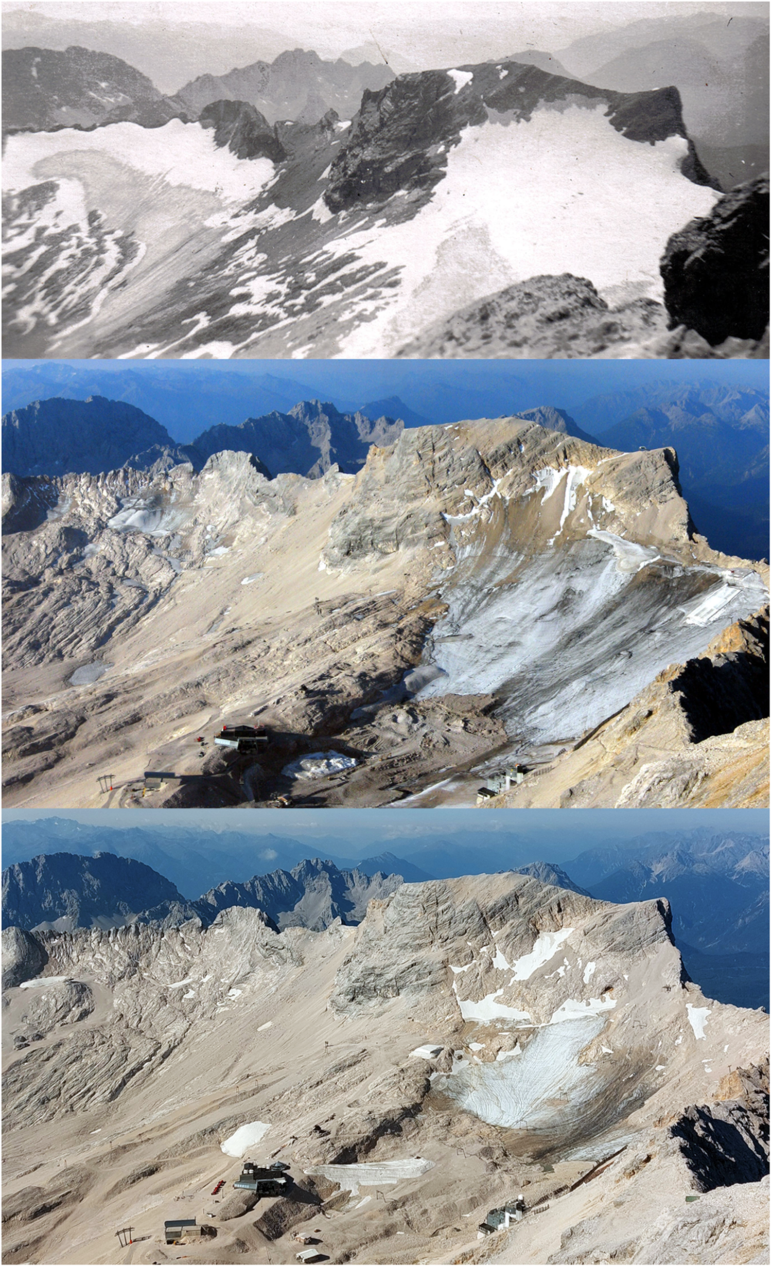
Südlicher (left) and Nördlicher (right) Schneeferner as seen from the Zugspitze summit terrace in 1942 (above, photo: Johann Hagg), 2006 (middle, photo: Wilfried Hagg) and 2025 (below, photo: Wilfried Hagg). In the lower parts of the two younger photos, the “glacier station” Zugspitzplatt of the cogwheel train (ZP, left of the center) and the Environmental Research Station Schneefernerhaus (UFS, right of the center) are visible.
Concerning the technical development of the access to the Zugspitzplatt, a cogwheel railway was opened to this area already in 1930, initiating mass tourism to the ‘Top of Germany’. In 1931, a hotel opened on the slope above Nördlicher Schneeferner and since 1999, this building has been used as the ‘Environmental Research Station Schneefernerhaus (UFS)’. The first ski lift was installed in 1949, followed by several others. In 1956, the first T-bar lift traversed the Nördlicher Schneeferner; two others opened in 1967 and 1976 (Mayer, Reference Mayer, Job, Kempf, Lang-Novikov and Losang2025). The southern part of the Platt became accessible in 1979, with a lift terminating on top of Südlicher Schneeferner. Glacier retreat necessitated relocating this station onto bedrock by 2012. That same year, significant subsidence on Nördlicher Schneeferner led to the dismantling of a lift. Today, five ski lifts are capable of transporting nearly 9000 people per hour (www.skiresort.info), but only one of these is crossing the remnants of Nördlicher Schneeferner and this lift was not running in the season 2024/25 after 57 years of operation. In case it will not reopen, Germany has lost its only glacier ski area. Due to declining snowfall, the operating times of ski lifts have shortened from an average of 240 days in the 1960s to approximately 160 days in the 2020s (Mayer, Reference Mayer, Job, Kempf, Lang-Novikov and Losang2025). Despite its diminished state, Nördlicher Schneeferner is still a year-round tourist attraction (the terminus station of the cogwheel train is called ‘Gletscherbahnhof – glacier station’), although the awareness for the glacier is highest in summer, when an educational trail with six stations provides information about glaciers in the context of global warming. The Zugspitze attracts around 500 000 visitors a year, with more visitors in summer than in winter.
3. Methods
A total of 13 unpublished historical maps from 1892 to 2000, which were only published as paper versions, were scanned and georeferenced according to their coordinate grids. The coordinates are mostly in the outdated Gauss–Krüger system and partly in the even older Bavarian Soldner system. In order to create a standardized reference system, all original maps were reprojected into the UTM grid (Zone 32 N) which is in use today. Subsequently, contour lines and glacier boundaries were digitized manually and a digital elevation model (DEM) with a mesh size of 2 m was interpolated in a GIS system. The surveying technique of the historical maps was terrestrial photogrammetry. Haggren and others (Reference Haggrén, Mayer, Nuikka, Braun, Rentsch and Peipe2007) assessed the accuracy of a historic glacier map comparable with the Finsterwalder map from 1892. They concluded that the uncertainty in elevation can be up to 10 m, but likely is considerably smaller in regions with well identifiable features and short observation distances. For the photogrammetric maps of the second half of the 20th century, a mean elevation accuracy of one meter is estimated (Rentsch, pers. comm., 2006).
Surveys conducted in the 21st century employed terrestrial laser scanning and real-time kinematic Global Navigation Satellite System (GNSS) techniques. These methods have an elevation accuracy of 0.2 m (Lambrecht and others, Reference Lambrecht, Mayer, Wendt, Floricioiu and Völksen2018) and allowed the generation of elevation models with 1-m resolution. The most recent DEM for Nördlicher Schneeferner, from 2023, was derived from digital photogrammetry using a DJI Mavic Pro drone. Flights were planned with 80% image overlap in both, along and across flight directions, maintaining a consistent altitude of 100 m above ground via the “terrain follow” feature. Photogrammetric processing was performed using Agisoft Metashape software. Images captured by the drone’s 20-megapixel Hasselblad camera enabled the generation of a high-resolution elevation model (0.1 m), capable of detecting even small surface features such as rocks or even individual persons. The DEMs used for mass balance analysis were resampled to a 1-m grid. A comparison with a DEM of the surveying authority on surrounding stable rock yielded a root mean square error in elevation of 0.3 m. Since the glaciers no longer have an accumulation zone, a density factor of 0.9 kg m–3 was applied to convert volume changes into mass change estimates for the modern volume change investigations (post 2000). For the earlier maps, we have no direct information, but we can assume that more snow and firn was present. For this reason, we used the mean density factor of 0.85 kg m–3 proposed by Huss (Reference Huss2013).
In November 2006, glacier thicknesses were determined along several profiles on both glaciers using a RAMAC ground-penetrating radar (GPR) system equipped with 200 MHz antennas. Positioning was achieved via differential GNSS positioning using a Leica receiver and a reference station close to the Nördlicher Schneeferner. The radar data were processed with Reflex-W software, and bedrock interfaces were clearly identifiable in the radargrams. A standard radar wave velocity for temperate ice of 0.168 m ns−1 (Hubbard and Glasser, Reference Hubbard and Glasser2005) was used for depth conversion, because the measurements took place in the absence of a relevant snow cover. Ice thickness points were compiled in a GIS system and interpolated into a raster using the multigrid interpolation procedure by Hutchinson and others (Reference Hutchinson, Xu and Stein2011). We tested the uncertainty of this procedure on two cirque glaciers in Italy, considering the determination of the reflection time in the radar data, assumptions on wave velocities and the interpolation of the thicknesses along the tracks to the entire glacier area (Hagg and others, Reference Hagg, Scotti, Villa, Mayer, Heilig, Mayer, Tamm and Hock2017). We trust that the resulting total uncertainty of 2 m, expressed as root sum of squares, is also valid for the glaciers on Zugspitzplatt.
4. Results
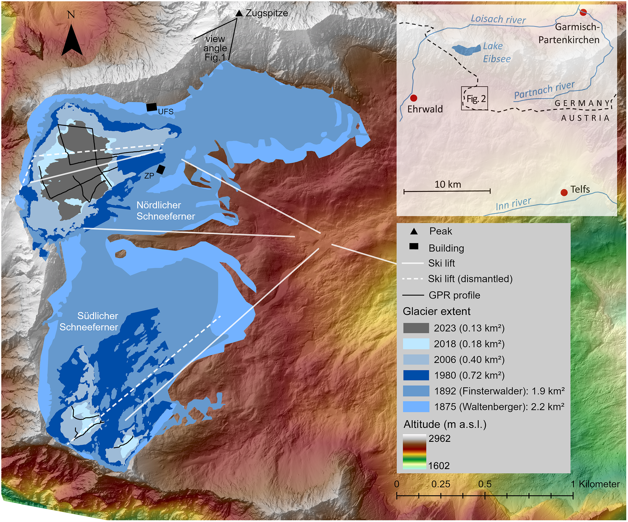
A selection of glacier outlines over the observation period is shown in Figure 2. Extents from 1950 to 1970 are omitted in this figure, because they are smaller than the extent in 1980. A notable temporary advance occurred between 1970 and 1980, when the area increased by approximately 30%, coinciding with a period of positive mass balances. Supplementary material Table S1 summarizes glacier area and mass for all surveys.
Glacier extent and infrastructure on Zugspitzplatt from 1820 to 2023 for selected years (UFS: Environmental Research Station Schneefernerhaus, ZP: Zugspitzplatt station).

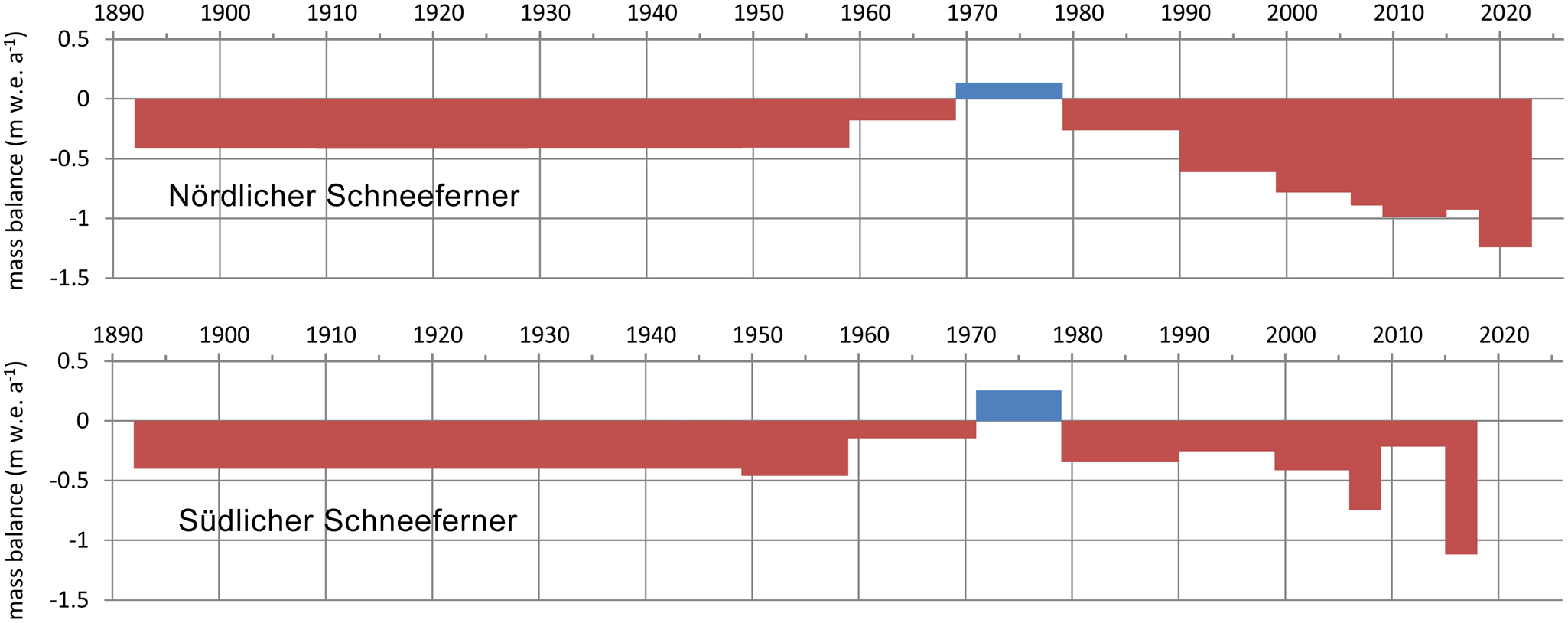
Figure 3 illustrates the geodetic glacier mass balances as bar diagrams of the mean annual change in water equivalent for the individual observation periods. Due to missing contour data, the earliest maps from 1820 and 1875 had to be excluded from this analysis. The first and longest period from 1892 to 1949 already shows high mean annual mass loss rates which did not change in the subsequent period from 1949 to 1959. In the next decade, mass loss rates decrease and in the 1970s, there were even mass gains. Positive mass balances and related glacier advances were very common in this decade across the Alps (Zemp and others, Reference Zemp, Haeberli, Hoelzle, Paul, Orlove, Wiegandt and Luckman2007). They are attributed to reduced solar radiation – referred to as ‘global dimming’ (Wild, Reference Wild2009). From the 1980s onward, the mass losses increase again. Südlicher Schneeferner experienced a curious stabilization between 2009 and 2015, followed by record losses from 2015 to 2018. No further geodetic mass balances were computed beyond this time. In 2022, the remaining ice was observed to be thinner than 2 m in most places and classified as dead ice, but no elevation model was created and it remains unclear exactly when the active flow and thus the existence as a glacier ended.
Mean annual glacier-wide mass balance of Nördlicher and Südlicher Schneeferner from 1892 to 2023. Mass balance is expressed in meters of water equivalent.
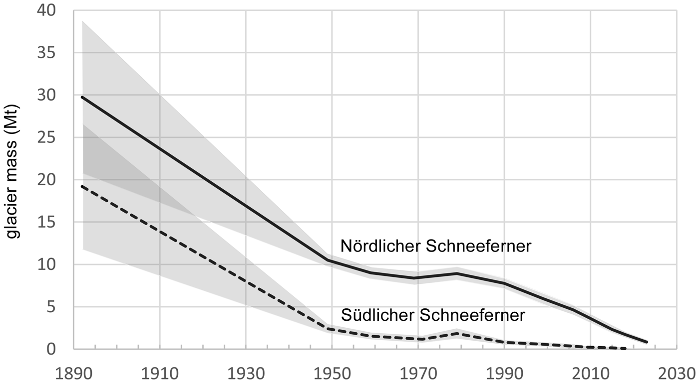
Ground-penetrating radar (GPR) measurements in 2006 revealed maximum and mean ice thicknesses of 17.8 m and 5.2 m, respectively, for the Nördlicher Schneeferner, corresponding to a volume of 5.16 × 10⁶ m3. The Südlicher Schneeferner was considerably thinner, with a mean thickness of 4.6 m and a maximum of 16.5 m, totalling 0.4 × 10⁶ m3 in volume. Combined with a DEM-based volume change analysis, the so derived glacier volumes allowed the reconstruction of glacier mass evolution from 2006 onwards and back in time (Fig. 4).
Evolution of glacier mass in megatons of ice on Zugspitzplatt (1892–2023), the shaded area represents the uncertainty range.

The glaciers show strong and rather similar mass loss rates from 1892 to -1949. At the end of this period, Südlicher Schneeferner contained less than 25% of the total ice mass of 1892, although its extent accounts for 71% of the total glacier area on Zugspitzplatt. This illustrates its considerably lower mean thickness compared to Nördlicher Schneeferner. One reason for this might be that in contrast to its northern counterpart, Südlicher Schneeferner could not excavate a cirque and the ice is situated on the undulated bed, which is less affected by glacial erosion. After the slowdown in mass loss and the gains in the 1970s, Südlicher Schneeferner quickly reduced to a very small volume. From 1990 onward, it contained less than one megaton of ice, but the rate of mass loss was now considerably reduced, compared to Nördlicher Schneeferner. Interestingly, the latter also exhibited lower mass loss rates after 1990 compared to the period before 1949. The large mass loss rates in the earliest period are due to the fact that there was still a lot of ice cover on the lower part of the Zugspitzplatt, which caused a great imbalance after the rise of the equilibrium line altitude after the LIA. However, if these mass losses are normalized to the glacier area, they were lower than after 1990 (Fig. 3). In 2023, Nördlicher Schneeferner had less than one megaton of ice left. The ice loss on Zugspitzplatt in this century (1999–2023) is 88%, which is more than double compared to the mean value for Central Europe of 38.7% (The GlaMBIE Team, 2025). Small glaciers react stronger to climate change than larger ones, because the shift in ELA affects relatively larger areas of the glacier and quickly exposes the entire glacier to ice ablation.
5. The future
The end for the glaciers on Zugspitzplatt is near. If current mass loss rates persist, the last ice will probably vanish around 2030. However, the last remnants of glacier ice in shady hollows and thus protected from solar radiation can last longer than expected. Maybe this was the reason for the slowdown in mass loss rates at Südlicher Schneeferner towards the end of its existence. Nevertheless, it is undisputed that the end of glacier ice on the Zugspitzplatt is imminent. Since many years, no accumulation area exists and the glacier can no longer find an equilibrium in today’s climate. Although the deglaciation of Zugspitzplatt is a significant signal of environmental change and should serve as a wake-up call, the ecological and economical implications remain limited. The entire area is already strongly influenced by anthropogenic activity. Threats to biodiversity in this sparsely vegetated area are limited to specialized microorganisms that are affected worldwide by glacier retreat (Ezzat, Reference Ezzat2025). The ski resort will lose a lift and summer visitors will lose an attraction, but Germany’s highest mountain will remain a crowd-puller even without a glacier. The glacial overdeepening of the bedrock at Nördlicher Schneeferner could be filled by a 16 m deep tarn (Hagg and Krautblatter, Reference Hagg, Krautblatter, Lehmkuhl, Böse and Krautblatter2025), but since the heavily karstified Wetterstein limestone preferably drains underground, it is unlikely that a new tourist attraction in the form of a lake will emerge here in the long run. As a water storage, the glacier is irrelevant, even for the local infrastructure, because the nearby restaurant (Haus Sonnalpin) and the environmental research station (Schneefernerhaus) are supplied via a pressurized pipeline from the valley. So long, mate!
Supplementary material
The supplementary material for this article can be found at https://doi.org/10.1017/aog.2026.10042.
Acknowledgements
The authors thank the Bavarian Academy of Sciences and Humanities for financial support over the past decades. The open access fund of the Munich University of Applied Sciences contributed to the financing of the paper. We also acknowledge the support of the Bayerische Zugspitzbahn and the Environmental Research Station Schneefernerhaus. We would like to thank two anonymous reviewers and the editor for their constructive comments.


 Open access