

Introduction
In December 2008, a 320 km over-snow tractor traverse was conducted by the Centro de Estudios Científicos (CECS) with the support of Antarctic Logistics and Expeditions (ALE), through the southern part of the Ellsworth Mountains, West Antarctica, from Patriot Hills (80˚18’ S, 81˚22’ W) to Union Glacier (79˚46’ S, 83˚24’ W) (Fig. 1). Union Glacier flows into the Constellation Inlet of the Ronne Ice Shelf, which has been stable in recent decades in spite of recent atmospheric warming affecting the Antarctic Peninsula and West Antarctica (Reference Steig, Schneider, Rutherford, Mann, Comiso and ShindellSteig and others, 2009). The Ronne Ice Shelf is fed by several ice streams, Union Glacier being one of the smaller and Rutford Ice Stream one of the main contributors (Reference Rignot and ThomasRignot and Thomas, 2002).
Location map based on a RADARSAT mosaic from West Antarctica with contour lines from RAMP (light grey). The traverse route, where radar and GPS were measured, is shown in blue. Crevasse fields are shown in red. Green line shows stakes installed in 2007 and resurveyed in 2008, yellow circles show other stakes installed in 2008, and light blue dotted line shows the grounding line position. Union Glacier basin is shown in light blue shade. Base camps are indicated by ’X’.

Further north in the peninsula, several large ice shelves (e.g. Wordie, Larsen A and Larsen B) have collapsed in recent decades (Reference Vaughan and DoakeVaughan and Doake, 1996; Reference Scambos, Bohlander, Shuman and SkvarcaScambos and others, 2004). As a consequence, many glaciers have accelerated and thinned (Reference RignotRignot and others, 2004, Reference Rignot2005). The main driving force behind these changes is the rapid recent atmospheric warming trend observed in the Antarctic Peninsula (Reference TurnerTurner and others, 2005). This atmospheric warming has been confirmed further south by borehole measurements performed at Rutford Ice Stream (in a location 182 km north of Union Glacier). However, a similar measurement at Subglacial Lake Ellsworth (173km west of Union Glacier) did not exhibit any significant trend (Reference Barrett, Nicholls, Murray, Smith and VaughanBarrett and others, 2009).
Rutford Ice Stream, which is much larger than Union Glacier, is characterized by tidally modulated ice flow (Reference GudmundssonGudmundsson, 2006) with surface velocities between 87 and 375 ma−1 at distances between 240 and 40 km from the grounding line (Reference KingKing, 2009). Ice-flow velocities are stable over recent decades (Reference Gudmundsson and JenkinsGudmundsson and Jenkins, 2009), and the glacier has a near-equilibrium net balance (Reference Rignot and ThomasRignot and Thomas, 2002). Recent studies indicate that its basin is thickening slightly (Reference ZwallyZwally and others, 2005; Reference Wingham, Shepherd, Muir and MarshallWingham and others, 2006; Reference Vaughan, Corr, Smith, Pritchard and ShepherdVaughan and others, 2008). The Ronne Ice Shelf, in which Rutford Ice Stream flows, is not vulnerable to a disintegration process such as affects ice shelves in the Antarctic Peninsula (Reference Vaughan and SpougeVaughan and Spouge, 2002).
Considering the above characteristics, what kinds of changes are expected at Union Glacier?
Union Glacier has an estimated total area of 2561 km2, according to the RADARSAT-1 Antarctic Mapping Project (RAMP) digital elevation model (DEM), with a total length of 86 km from the ice divide with Institute Ice Stream down to the grounding line at Constellation Inlet. It is composed of several glacier tongues. The main trunks (Union and Schanz; Fig. 1) feed through narrow valleys (9 km wide) from the interior plateau before joining together at the ‘gate’. This gate, which is the narrowest section of the glacier (7 km wide), is characterized by a bare ice surface or blue-ice area (BIA) and a central moraine line (Fig. 2), the latter composed of clasts and small debris. The Union Glacier BIA is located where katabatic winds are enhanced. A 21-stake array for determining ice velocities was installed at this location in 2007, in order to determine surface mass loss.
Ice velocities at the Union Glacier gate measured between December 2007 and 2008. The inset shows the BIA and the GPS rock station installed in 2008 (CECS GPS point as a red dot), which is close to the USGS metal pin installed in 1962/63 (USGS, 1966) and resurveyed in 2008. Dashed blue line shows the surface radar track of the profile shown in Figure 3.

Thus the aim of this research is to study the ice dynamics and basic glaciological characteristics of Union Glacier, providing a baseline for future modelling studies of glacier behaviour. Since the 1962/63 expedition conducted by the US Geological Survey (USGS), and an airborne survey by the British Antarctic Survey in 1974/75 (Reference Lythe and VaughanLythe and others, 2001), very little work has been done on Union Glacier. In 2008, a survey was organized using dual-frequency GPS receivers, a radar for deep ice measurements and a ground-penetrating radar (GPR) for crevasse detection. These sensors were mounted on a convoy pulled by a Camoplast tractor. The traverse, from the Patriot Hills summer camp used by ALE to Union Glacier, lasted 2 weeks. Several stakes were installed along the traverse to measure ice velocities, and continuous GPS measurements were performed all along the track to survey the surface topography.
Methods
Remote sensing
Analysis of satellite imagery has been shown to be especially useful for mapping remote areas in Antarctica (Reference BindschadlerBindschadler, 1998). Applications include monitoring fluctuations in the extent of BIAs (Reference Casassa, Rivera, Acuña, Brecher and LangeCasassa and others, 2004), ice velocity determination (Reference Stearns and HamiltonStearns and Hamilton, 2005) and detecting the position and variations of the grounding line (Reference RignotRignot, 1998). In this work we combine Advanced Spaceborne Thermal Emission Reflection Radiometer (ASTER) satellite images with ground-based GPS and radar data in order to map crevasse fields and plan safe over-snow traverse routes.
Crevasse fields can be detected on the ASTER visible/near-infrared (VNIR) colour composite images and in the RAMP mosaic. They appear as discontinuities on the snow surface, sometimes as open linear features but more often covered by snow and only evident by the shadows cast by snow built up at the edges of the crack. The fact that the crevasses are marked by linear discontinuities on the image allows them to be detected (Reference Bindschadler and VornbergerBindschadler and Vornberger, 2005), both visually and by applying filters (e.g. high-pass).
Differential GPS
A 21-bamboo-stake network was installed on Union Glacier in December 2007, using Topcon GR3 dual-frequency GPS receivers (Fig. 1, green colour). Due to logistic/weather constraints, differential GPS measurements lasted <30 s per stake, yielding position errors of the order of 1 m. An independent survey was done in December 2008, with dual-frequency Javad GPS model Lexon GD receivers, used to survey the ice surface as well as the stakes installed in 2007. To improve the accuracy of the second-year survey, a new GPS base metal pin was drilled and glued to a rock outcrop located near the base camp at Union Glacier (Figs 1 and 2). This point was used as a GPS base station, and was surveyed simultaneously with the other measurements (i.e. kinematic for radar and stop-and-go for the stakes). Each stake was measured for approximately 30 min, allowing a precise positioning of all of them (better than 10 cm accuracy). Comparing the position of these 21 stakes yields a detailed record of ice velocities over the 12 month period, with an estimated combined error of 1 m. In 2008, 13 stakes were also installed along the convoy track (Fig. 1, yellow colour), which will allow a better understanding of the ice dynamics in the future.
Ice thickness
A pulse-compression radar depth sounder (ULUR-1.5) was designed and built by CECS for thickness measurements in deep cold ice. The radar operates at a central frequency of 155 MHz, with a bandwidth of 20MHz, a sample rate of 100 MHz and peak power of 200 W. Eight-element Yagi antennae were used for both the transmitter and receiver. Post-processing included an adjustment of the gain function to the raw data, mainly to enhance the bedrock echo.
Results
Subglacial topography
During the radar survey, data were collected over 320 km (Fig. 1). The first part of the surveyed profile, crossing the Horseshoe Valley, yielded a maximum thickness of 2120 m, in an area where previous radar campaigns were unable to penetrate the total ice thickness (Reference Casassa, Rivera, Acuña, Brecher and LangeCasassa and others, 2004).
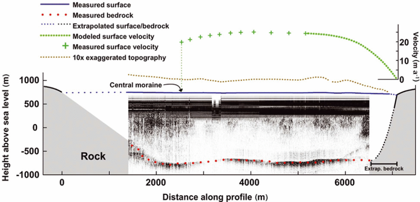
The smaller glaciers situated at the northern flank of the Horseshoe Valley (Plummer and Seal Glaciers) have maximum ice thicknesses at their centre flowline of 386 and 428 m, respectively. Several profiles were surveyed on Union Glacier, yielding a mean ice thickness of 1450 m along the gate (Fig. 3), where the stake network was installed in 2007. The subglacial topography of the valley has U-shaped flanks and very small roughness.
Cross-section (gate) where ice flux was calculated. Surface topography measured with GPS is shown in blue. The blue dotted line is the surface topography extrapolated to the rock margins, and the brown dotted line shows the same topography with vertical exaggeration. Black lines represent rock at the glacier margin. Black dotted line shows the interpolated subglacial topography data as described in the text. Green crosses show measured surface velocities, and green dotted line shows modelled values. The radargram of the glacier cross-section is also displayed, indicating the interpreted subglacial topography as red dots. The banding that obscures the uppermost 500 m in the radargram is due to system saturation.
Mass balance
The stakes installed in 2007 at the glacier gate (Fig. 2) were resurveyed after 1 year, when a negative mass balance was detected, with a lowering of 16 ± 1 cm of the ice surface (error of 4 cm in each stake height difference). This value is consistent with the prevailing BIA condition in this sector of the glacier.
Ice-flux computation
The main input to compute the ice flux is the horizontal displacement of the 21 stakes. The mean displacement of the stakes is 22.6 m a−1, with maximum velocities of 2 4 . 5 ± 1ma−1 and minimum velocities of 19±1ma−1 at the central moraine of the glacier. These velocities are one order of magnitude lower than those of Rutford Ice Stream, and are typical for ice frozen to the bed (Reference Vaughan, Corr, Smith, Pritchard and ShepherdVaughan and others, 2008).
Ice flux was modelled through the gate where ice surface velocities were measured between 2007 and 2008 (Fig. 2). The glacier width at this gate is 7 km, and the model domain covers a subsection of 4.59 km from the central moraine (where the main flow of Union Glacier joins Schanz Glacier) to the lateral side (Fig. 3). Surface topography was measured with GPS, allowing positions to be determined approximately every 9 m along track, covering most of the modelled section. The 150 m separating the end of the surface topography profile and the glacier margin (where the terrain was inaccessible for the surveying system) were extrapolated with a sinusoidal curve, resulting in a 24 m height drop, approximately matching field observations.
Ice thickness at this gate, measured with the radar system, was approximately 1456 m. Over the last part of the profile before the glacier margin (approximately 550m horizontally), where the radar profile was obscured by lateral reflection coming from the rock wall, the bed elevation (-697 m) was interpolated up to the ice/rock margin contact by a parabolic function (X distance 6500–7000 in Fig. 3).
Ice velocities were computed in two steps: (1) by defining the surface velocities across the gate by combining measured with modelled values and (2) by estimating the vertical change in horizontal velocities.
1. Surface velocities
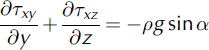
The surface velocities between the measured stakes along the profile (Fig. 3) were linearly interpolated. For zones lacking stakes (the last 2 km), ice velocities were calculated using the model for valley glacier velocities described by Reference NyeNye (1965), where the horizontal and vertical variations are governed by
where rxy and Txz
are shear stresses ![]() α is the surface slope along the flowline, g is the gravitational acceleration constant and A is Glen’s flow-law parameter. z is the vertical coordinate measured upwards, x is measured in the flow direction and y is the horizontal coordinate measured from the centre of the glacier towards the side perpendicular to the flux; u is the ice velocity along the x axis.
α is the surface slope along the flowline, g is the gravitational acceleration constant and A is Glen’s flow-law parameter. z is the vertical coordinate measured upwards, x is measured in the flow direction and y is the horizontal coordinate measured from the centre of the glacier towards the side perpendicular to the flux; u is the ice velocity along the x axis.
We used ρ = 900 kg m−3, g=9.81ms–2 and A=1.7×10⁻¹⁶ kPa−3 s−1, which is recommended for ice at –20˚C (Reference PatersonPaterson, 1994). The slope a in the profile section was estimated for the section immediately upstream of the gate, where slopes of 0.5–108 were found, with an average value of 1°.
Since Txz = 0 at the surface (Reference PatersonPaterson, 1994), Equations (1) and (2) can be rewritten as
Both equations were numerically integrated, using the measured surface velocities as initial condition, in order to complete the surface velocities to the gate margin. Integration constants were numerically adjusted during each iteration to match the boundary condition of u = 0 at the rock/ice contact (assuming no basal sliding).
2. Integrating velocities through the vertical column
Using the above surface velocities, subsurface velocities were calculated analytically, using Glen-type rheology under steady laminar flow for n = 3. Under these conditions, depth-averaged velocities are 80% of surface velocities (Reference PatersonPaterson, 1994). This results in a total flux of 0.10 km3 a−1 w.e. (using ρ = 900kgm−3). Figure 3 shows the geometric setting of the gate with the surface measured velocities. Considering that the basin upstream of the modelled gate has an area of 559 km2, a mean net surface mass balance of 0.18 m a−1 w.e. is needed to keep the glacier in a steady state. This average net mass includes high spatial variability, with areas of net accumulation at the plateau at the top of the basin and areas with strong ablation/sublimation evidenced by the BIAs near the measured gate.
Multiple error sources remain in the total modelled ice flux, including differences between modelled and measured surface velocities. As a result, it is very difficult to assess the magnitude of this difference. However, it is very easy to establish a reasonable maximum value by considering a constant surface and subsurface ice velocity of 22.6 m a−1 (the mean value of the 21 measured stakes), leading to a flux of 0.13 km3 a- 1 w.e., 30% more than the modelled flux. Assuming a 30% relative error, the total flux would be 0.10±0.03 km3 a−1 w.e., yielding an equilibrium net mass balance of 0.18±0.05 ma−1 w.e.
Discussion and Conclusions
Surface and subglacial topographies
The surface and subglacial topography measured during the 2008 campaign provide more precise and detailed results than those available until now (Fig. 4).
Surface and bed profiles collected along the CECS 2008 traverse from Union Glacier to Patriot Hills, and compared to ICESat and BEDMAP data.
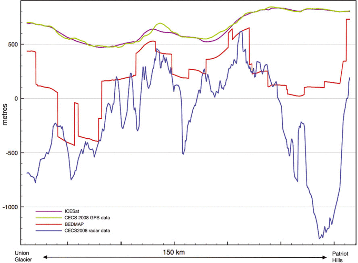
Surface topography, resulting from the GPS survey in 2008 (decimetre precision), is similar to the available Ice, Cloud and land Elevation Satellite (ICESat) data general topography (500 m pixel size), with some anomalies in areas characterized by a rougher topography, but generally consistent with a mean difference of <5m.
Subglacial topography obtained in 2008 is, however, very different to the BEDMAP data (Reference Lythe and VaughanLythe and others, 2001), which is to be expected in view of the sparsity of available measurements in this area prior to the 2008 campaign. Comparison between BEDMAP and the new dataset shows differences of >50% along the same track where subglacial topography is below sea level (Fig. 4). For example, the deep valleys along this track are not represented correctly in BEDMAP. Thus it seems that Union Glacier is located in a much deeper subglacial valley than previously estimated.
Comparing 2008 ice-thickness measurements with BED-MAP shows a reasonable relation in general, but in areas with steep basal slopes and deep subglacial beds, differences are as high as 66% of the ice thickness. The difference between BEDMAP and the new ice-thickness data is most pronounced in the vicinity of Patriot Hills, where the comparison exceeds 1300m (Fig. 4).
Glacier mass balance
It is not yet possible to establish the net mass balance of Union Glacier, but most evidence suggests a near-equilibrium state. Accumulation for this area inferred from regional atmospheric models indicates values of 0.09–0.34m a−1 w.e. (Reference Van den Broeke, van de Berg and van MeijgaardVan den Broeke and others, 2006), consistent with the range of the estimated equilibrium net mass balance inferred from our ice-flux model (equivalent to an accumulation of 0.13–0.23 m a−1 w.e. neglecting ablation/sublimation). These values are similar to the results obtained at the Horseshoe Valley, where GPS surveys have been done in addition to stake mass-balance measurements since the mid-1990s, resulting in a balance accumulation of 0.17 ma−1 w.e. (Reference Wendt, Casassa, Rivera and WendtWendt and others, 2009).
In order to determine more precisely the present mass balance of Union Glacier and its possible future trends, it will be necessary to further constrain the bedrock topography (to anticipate dynamic glacier responses), as well as to acquire more representative accumulation/sublimation measurements. For this purpose, new radar profiles from the Union Glacier gate down to the local grounding line, following the central flowline, as well as along several transversal cross-sections, will be necessary. These profiles seem feasible in areas where crevasse fields are lacking. In addition, radar profiles and GPS surveys for both velocity determination and surface accumulation should complete the analysis.
Acknowledgements
The field campaign was funded and supported by Antarctic Logistics and Expeditions (ALE). The research was funded by CECS; the Bicentennial Science and Technology Programme of CONICYT (Scientific and Technological National Commission of Chile)/World Bank; and INACH (the Chilean Antarctic Institute). The project is within the framework of the International Polar Year 2007–09. CECS is sponsored by the Millennium Science Initiative (ICM), the Excellence Centers of CONICYT Basal Financing Programme and the Regional Government of Los Ríos, among many others. J. Wendt (deceased) and A. Wendt provided valuable help with the analysis of GPS data. C. Bravo collaborated on the figures. We thank F. Pattyn, the Scientific Editor, and also N. Ross and an anonymous reviewer for comments that improved the manuscript. M. Sharp and ALE staff at Patriot Hills provided valuable help during the field campaign.


