


Introduction
While it is valuable to compare the movements of people and the trajectories of trade in prehistory, it is even more intriguing to investigate their reorganisation after periods of geopolitical instability. The Final Bronze Age (second half of the twelfth century BC) in northern Italy saw the collapse of the Terramare settlement system and the rise of Frattesina as a nodal centre between the Mediterranean and continental Europe. Here, we use strontium isotope analysis to investigate the origins of elite and non-elite individuals in this community, and to investigate the role that outsiders may have had in the rise of Frattesina.
Collapse of the Terramare system and regeneration
The middle centuries of the second millennium BC (1650–1150 BC) saw the rise and flourishing of the Terramare settlement system in the Po River plain of northern Italy. The Terramare can be defined as mainly quadrangular settlements surrounded by an artificial embankment and ditch into which the waters of a nearby river or natural canal were re-routed. Approximately 200 of these sites are currently known in the central Po Plain: they could reach 20ha in size and occupied the territory very densely. The level of social and economic organisation of these communities was unprecedented in Italian prehistory, and thus the Terramare have long attracted the attention of European prehistorians.
The collapse of the Terramare system c. 1150 BC was followed by a sudden and substantial depopulation of the central part of the Po Plain (Cardarelli Reference Cardarelli2009). At the beginning of the Final Bronze Age, the southern part of the Po Valley was almost abandoned. In contrast, in the northern part of the Po Valley, some villages survived: the large terramara at Fondo Paviani (16–20ha), for example, continued through the transition between the Recent and Final Bronze Age, and experienced a crisis in the early stages of the latter (Final Bronze Age 1–2), leading to the abandonment of the site. Concurrently, a new territorial system arose, pivoting around the socio-economic pole of Frattesina (Calzavara Capuis et al. Reference Calzavara Capuis, De Guio and Leonardi1984; Bietti Sestieri et al. Reference Bettelli, Cupitò, Levi, Jones, Leonardi, Leonardi and Tinè2015; Cupitò et al. Reference Cupitò, Leonardi, Longa, Nicosia, Balista, Corso and Kirleis2015). Therefore, within the area of the wider Terramare ‘culture’, local responses to the crisis led to different outcomes, some of which were relatively successful and others catastrophic. Economic factors—both in terms of internal carrying capacity and degree of openness to external relations—probably played a key role in determining different responses to the tensions.
It has been repeatedly stated that the collapse of the Terramare system may have been triggered by a series of concurrent factors, including environmental crises (e.g. prolonged drought), over-exploitation of the land, and famine or epidemic (Cardarelli Reference Cardarelli2009; Cremaschi Reference Cremaschi2009; Leonardi Reference Leonardi2010). Nevertheless, while such environmental factors were probably involved, a key explanation arguably lies in the socio-political and economic organisation of the Terramare system (Cardarelli Reference Cardarelli2009: 471–72). The communities of the Terramare, especially in the southern area, were probably not flexible enough to adapt their political structure and modes of production to the needs of a rapidly changing world. Moreover, the domino effect from the overall geo-political instability of the twelfth century BC, in a highly interconnected system such as the Mediterranean, was undoubtedly another factor (Cardarelli Reference Cardarelli2009). The lack of evidence in the southern Terramare area for connections with the Aegean and the Levant suggests a more ‘closed’ system located on the edge of the ‘globalised’ world of the Late Bronze Age. In contrast, there is well-documented evidence from the largest terramare on the northern side of the Po River for possible incipient institutionalised, well-connected elites—particularly at Fondo Paviani, which has yielded locally produced pottery in Levantine and Late Helladic IIIC Aegean-Mycenaean styles (Bettelli et al. Reference Bettelli, Cupitò, Levi, Jones, Leonardi, Leonardi and Tinè2015). During the last phase of the Terramare (1300–1150 BC), however, individual burials do not exhibit the wealth or reflect the social power of society that is suggested by the monumental and material evidence of these settlements (Cardarelli et al. Reference Cardarelli, Cavazzuti, Quondam, Salvadei, Salzani, Leonardi and Tinè2015).
The display of austere equality that dominated the Middle and Late Bronze Age ‘urnfields’ (Salzani Reference Salzani2005; Cardarelli Reference Cardarelli2014) strongly limited funerary expressions of social differentiation. Internal inequalities nonetheless existed between different co-resident extended families and lineages comprising tens of individuals at most (e.g. at Casinalbo; Cardarelli et al. Reference Cardarelli, Cavazzuti, Pellacani, Poli and Cardarelli2014: 722–28), and, above all, between large centres, such as the terramara at Fondo Paviani and dependent satellite settlements (Balista et al. Reference Balista, Guio, Vanzetti, Betto, Angeli and Sartor2005; Cupitò et al. Reference Cupitò, Leonardi, Longa, Nicosia, Balista, Corso and Kirleis2015). It seems reasonable therefore to hypothesise that groups based at nodal sites in the system attracted more prestige goods from exotic places, along with individuals from distant areas, while small villages attracted people mainly from within a local radius (Cavazzuti et al. Reference Cavazzuti, Skeates, Millard, Nowell, Peterkin, Bernabò Brea, Cardarelli and Salzani2019a). Within this dynamic cultural context, the Final Bronze Age funerary evidence from Frattesina documents a more elaborate display of power and wealth concentrated in the hands of elites. At Le Narde (Frattesina's cemetery), this privileged segment of society, probably with its own entourage, is clearly represented by a small number of burials with several indicators of prestige.
Archaeological debate over the last decade has concentrated on the origin of these elite individuals and, more intriguingly, the founders of Frattesina. Was Frattesina a primarily indigenous community, which developed out of local dynamics and regeneration from the ashes of the Terramare system? Or did non-local groups from the Eastern Mediterranean contribute to its rise, and if so, to what extent?
Frattesina: between the Mediterranean and Central Europe
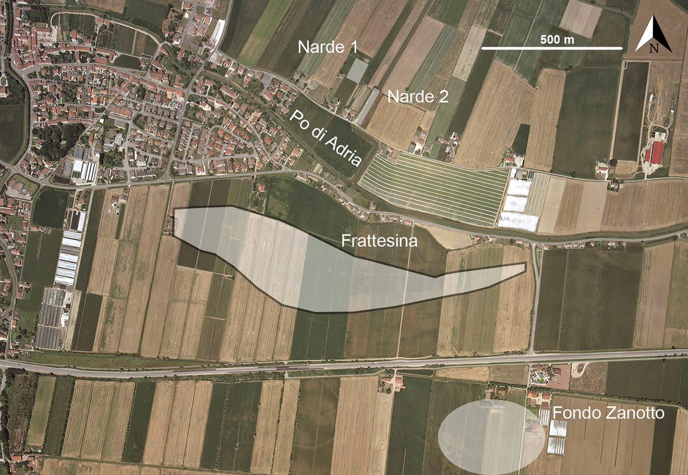
Frattesina di Fratta Polesine is unique among Late Bronze sites in northern Italy for its outstanding evidence of specialised workshops, exotic imports and rich cemeteries (Bietti Sestieri Reference Bietti Sestieri2008; Bietti Sestieri et al. Reference Bietti Sestieri, Bellintani, Salzani, Angelini, Chiaffoni, De Grossi Mazzorin, Giardino, Saracino, Soriano, Leonardi and Tinè2015). The settlement is located on the southern bank of the Po di Adria palaeochannel (Figure 1), 30–40km from the Bronze Age Adriatic coastline and the River Po delta. Extending over 20ha, the site is divided equally between a 10ha core and peripheral areas for cattle penning and agricultural production. Frattesina's economic prosperity must, in part, have been due to its strategic position at the crossroads between mainland, fluvial and maritime routes from the Alps to the Mediterranean. Definitions of Frattesina as a ‘central place’, ‘primary node’, ‘port of trade’ or ‘emporium’ recur frequently in the scholarly literature (e.g. Pearce Reference Pearce and Pare2000; Bietti Sestieri Reference Bietti Sestieri2008; Harding Reference Harding2013; Kristiansen & Suchowska-Ducke Reference Kristiansen and Suchowska-Ducke2015).
Aerial photograph of the Frattesina site (courtesy of the Regione Veneto website: http://mapserver.iuav.it/website/foto_aeree/). The white areas show the extent of the settlement and the two burial areas: Narde (comprising Narde 1 and 2 sectors) and Fondo Zanotto.
Since the late 1960s, a series of archaeological investigations has been conducted on the settlement and its two associated urnfields, Fondo Zanotto and Le Narde. Le Narde has been more extensively excavated and analysed, both archaeologically and osteologically (e.g. Salzani Reference Salzani1989, Reference Salzani1990; Salzani & Colonna Reference Salzani and Colonna2010; Cavazzuti Reference Cavazzuti2011; Cardarelli et al. Reference Cardarelli, Cavazzuti, Quondam, Salvadei, Salzani, Leonardi and Tinè2015).
Excavations at Le Narde have targeted two distinct sectors, Narde 1 and 2 (Figure 1), which have yielded, respectively, more than 600 and 200 urn cremations, plus 3 and 22 inhumations. These features extend from the Final Bronze Age 1 (c. 1150 BC), soon after the collapse of the Terramare culture, to the earliest phases of the Early Iron Age (c. 950/925 BC). In both sectors, the ratio between Final Bronze Age 1–2 (phase 1) and Final Bronze Age 3 to Early Iron Age 1 (phase 2) burials is balanced, with a slight increase in the number of burials in the latter phase (40 and 60 per cent, respectively). At Narde 1, the large and dense burial groups expand both horizontally and vertically. The outcome of this progressive vertical growth is a mound of up to five levels of depositions (Figure 2). This indicates a strong desire to emphasise membership of a specific corporate group (Leonardi & Cupitò Reference Leonardi and Cupitò2004; Cardarelli et al. Reference Cardarelli, Cavazzuti, Quondam, Salvadei, Salzani, Leonardi and Tinè2015).
Top) map of the Narde 1 burial sector, with the location of burials Narde1-168 and 227; bottom) section of the mound formed by the superimposition of urns (after Salzani Reference Salzani1989, Reference Salzani1990).
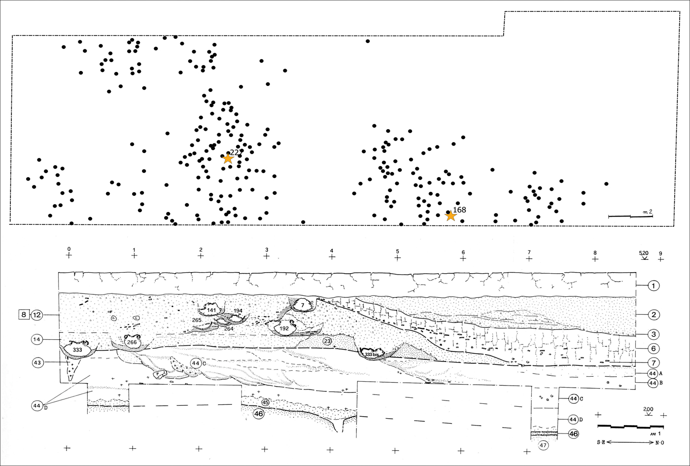
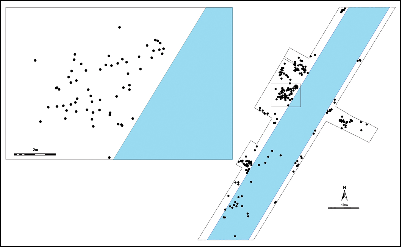
Despite the damage caused by the recent insertion of a drainage channel across the cemetery, the spatial organisation of Narde 2 is quite clear and rather different to that of Narde 1. Burials are organised spatially in larger and smaller groups, which range from 15–60 graves each. These groups tend not to be superimposed, but rather to expand horizontally (Figure 3). A recent analysis of grave goods and the sex/age categories of individuals from Narde 1 and 2 identifies five different ranks of adult males, females and sub-adults, ranked on a scale of 1–5 depending on the increasing quantity and quality of grave goods (Cardarelli et al. Reference Cardarelli, Cavazzuti, Quondam, Salvadei, Salzani, Leonardi and Tinè2015). The richest burials among the adult males—characterised by the presence of swords and toiletry objects—are represented by two ‘warrior-chief’ graves (Narde1-168 and Narde1-227). Both are located in Narde 1 at the centre of two distinct burial groups comprising more than 100 graves (Salzani Reference Salzani1989; Bietti Sestieri Reference Bietti Sestieri2008) (Figure 2). Another four graves contain only the rivets from a sword in place of a whole sword—probably a pars pro toto symbolising the warrior status of the deceased (Narde1-32, 154, 177, 273) (Leonardi Reference Leonardi2010). Similarly, the nine richest female graves, containing prestige goods such as amber and glass beads, are located almost exclusively in Narde 1, with only one in Narde 2. Thus, Narde 1 appears to be an area designated for elite groups and their entourage, while Narde 2 could have been reserved for less prestigious yet still dominant social groups.
Map of the Narde 2 burial sector, crossed by a modern irrigation channel (in blue); inset shows the detail of one burial group (after Salzani & Colonna Reference Salzani and Colonna2010).
Demographic data and first indicators of mobility
Osteological analyses have been undertaken on 472 burials: 266 from Narde 1, and 206 from Narde 2 (Table 1). Sex and age were determined through a combination of methods analysing morphological and metric traits (Ferembach et al. Reference Ferembach, Schwidetzky and Stloukal1980; Gonçalves et al. Reference Gonçalves, Thompson and Cunha2013; Cunningham et al. Reference Cunningham, Scheuer, Black and Liversidge2016; Cavazzuti et al. Reference Cavazzuti, Bresadola, D'Innocenzo, Interlando and Sperduti2019b).
Frequency of categories of individuals at Narde 1 and 2.
For both Narde 1 and 2, the sex ratio is close to 1:1, with slightly more adult males at Narde 1, and more adult females at Narde 2. The most marked difference between the two sectors is the frequency of sub-adults, who comprise 21 per cent of the burials at Narde 1 and 31 per cent at Narde 2. While this discrepancy is observed in all the sub-adult age classes, it is most clear among older infants (Infans 2 class; 7–12 years); these individuals are twice as common at Narde 2.
These divergent mortality rates among children may mirror different life expectancies and conditions (Cardarelli et al. Reference Cardarelli, Cavazzuti, Quondam, Salvadei, Salzani, Leonardi and Tinè2015), albeit with different degrees of inclusion of adult strangers and newcomers, as migrants are more likely to be adult. In this scenario, Narde 1's elite groups might have incorporated significant immigration, while those buried at Narde 2 remained closer to the traditional demographic structure of kinship-based societies. In this article, isotopic analysis is used to test these demographic and social ‘inequalities’ that emerge from the two sectors of Le Narde.
Materials
Our sampling strategy aimed to analyse the strontium isotope ratios of individuals—and therefore their mobility—in relation to osteological and archaeological data (Table 2). Samples were selected on the basis of burial sector (Narde 1 and 2), funerary rite (cremation vs inhumation), sex, age at death, chronology and class of grave goods. In order to facilitate data correlation, the five previously published grave goods classes (Cardarelli et al. Reference Cardarelli, Cavazzuti, Quondam, Salvadei, Salzani, Leonardi and Tinè2015) were merged into three broader groups:
• Class 1) comprising exceptional combinations of fibulae and ornaments in female burials, and weapons, utensils and other prestige indicators in male burials.
• Class 2) comprising pins or fibulae (the latter sometimes combined with smaller ornaments and/or a spindle whorl) in male and female graves, respectively.
• Class 3) characterised by the absence of grave goods or very few and/or poor-quality artefacts.
Sampling strategy. Number of individuals sampled for each archaeological and osteological parameter.
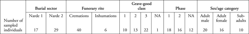
Of the 46 sampled individuals, 40 were cremated and 6 inhumed. Given the almost total absence of tooth enamel in cremations, we targeted the pars petrosa (petrous portion) of the temporal bone, which is frequently preserved in urn cremations. The petrous portion begins forming in utero at approximately 16–18 gestational weeks, and is fully ossified by the time of birth. The otic capsule in the inner part of the petrous portion undergoes no further remodelling after the age of two years (Sørensen et al. Reference Sørensen, Bretlau and Jørgensen1992; Sørensen Reference Sørensen1994; Jeffery & Spoor Reference Jeffery and Spoor2004). Considering that the petrous portion forms primarily before the end of weaning, its strontium isotope ratio is assumed to reflect the origin of the food consumed by the woman who breastfed the infant (Sørensen Reference Sørensen1994). It also seems reasonable to assume that, in the vast majority of cases, the infant's mother/wet nurse did not change over the duration of breastfeeding, did not move long distances and did not consume foods of a different origin. The petrous portion is suitable for strontium isotope analysis, as calcination of the bone increases its resistance to diagenesis while not significantly changing its strontium isotope composition (Harbeck et al. Reference Harbeck, Schleuder, Schneider, Wiechmann, Schmahl and Grupe2011; Harvig et al. Reference Harvig, Frei, Price and Lynnerup2014; Snoeck et al. Reference Snoeck, Lee-Thorp, Schulting, Jong, Debouge and Mattielli2015). In order to test the reliability and consistency of the pars petrosa results, we also sampled and analysed the surviving first permanent molar (M1) crowns of two sub-adults (burials Narde2-197 and Narde2-208); these two elements form at approximately the same age.
In the case of the prestigious ‘warrior-chief’ burial (Narde1-168), the cortical tissue of the femur was also sampled. As bone tissue remodels in life, its biogenic strontium isotope ratio reflects the place(s) where he spent the last decades of life (Hedges et al. Reference Hedges, Clement, Thomas and O'Connell2007). Grave Narde1-154, which contained only rivets to symbolise warrior status, was also sampled. For inhumations, we sampled enamel from permanent second molars (M2), the crowns of which develop between three and eight years of age (AlQahtani et al. Reference AlQahtani, Hector and Liversidge2010). Thus, the effects of breastfeeding on the isotope ratios of the M1 enamel are negated for planned future oxygen isotope analysis. In two cases (Narde1-25 and Narde1-59), we also analysed the enamel of permanent third molars (M3), which form between 8 and 15 years of age—to identify possible migration between childhood and adolescence. In order to represent all the geolithological units of the region, biologically available strontium baselines were collected from a database of 199 87Sr/86Sr values gathered from the existing literature, and 35 values produced in the Ex-SPACE project framework (Table S1 in the online supplementary material (OSM); Cavazzuti et al. Reference Cavazzuti, Skeates, Millard, Nowell, Peterkin, Bernabò Brea, Cardarelli and Salzani2019a).
Results
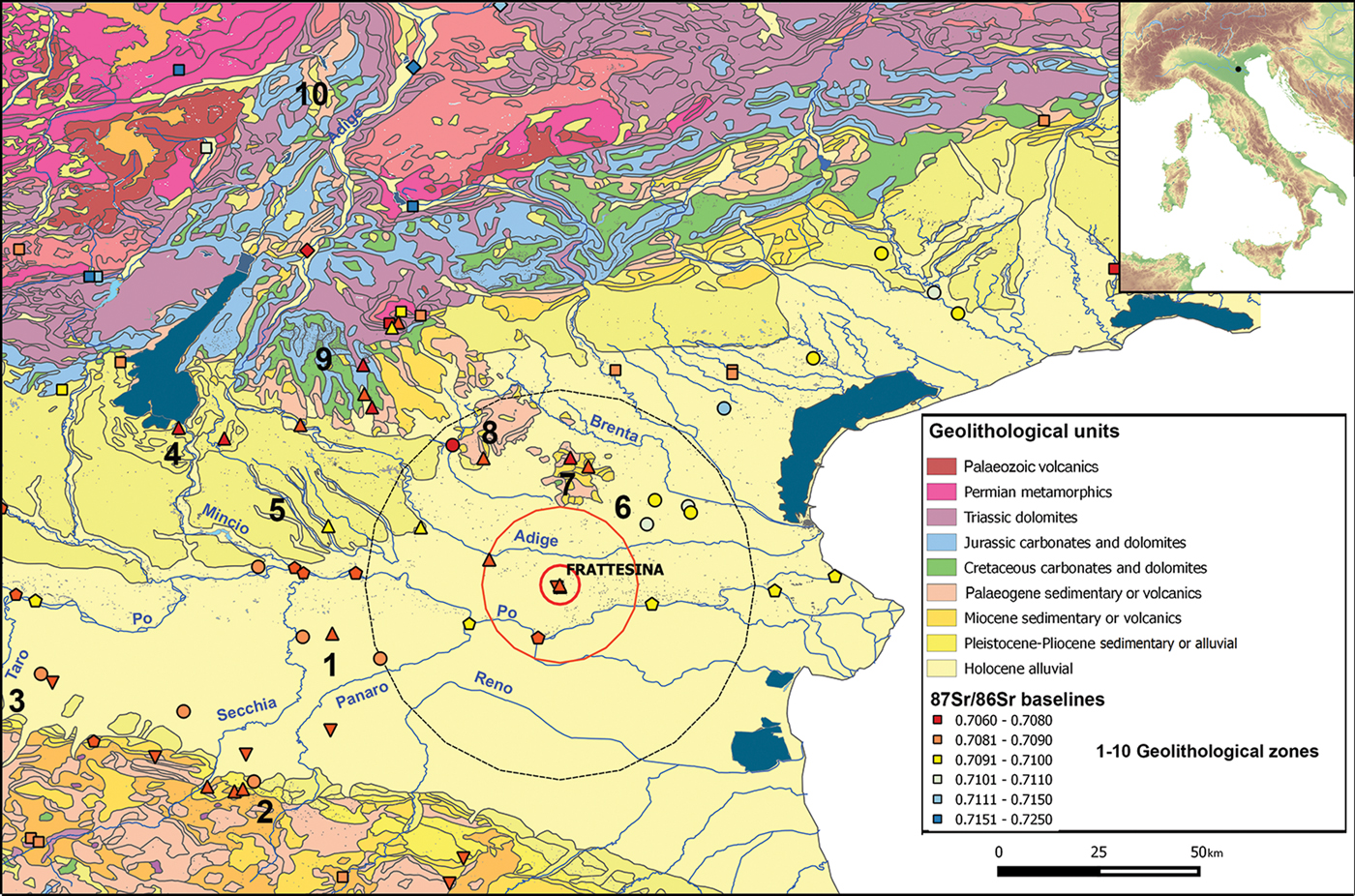
Full details of the methods used, including general principles and their specific application in northern Italy, are provided in the supplementary material (OSM). The results of the strontium isotope analysis in relation to archaeological and osteological data are shown in Table 3. The ‘isoscape’ of the Frattesina area—and more generally for north-eastern Italy—is shown in Figure 4.
Geolithological map of Frattesina and its surroundings. Circles around the site represent the two buffer zones (immediate hinterland and broader hinterland); markers indicate the 87Sr/86Sr baseline samples (dots = modern plants; squares = spring waters; pentagons = river waters; triangles = snails; inverted triangles = archaeological fauna; rhombi = soil leachates). Numbers indicate the zones detailed in Table S1 in the OSM (map under a CC BY licence, with permission from http://wms.pcn.minambiente.it/ogc?map=/ms_ogc/WMS_v1.3/Vettoriali/Carta_geolitologica).
Results of the 87Sr/86Sr analyses (Rite: C = cremation, I = inhumation; Sex/age: Inf1 = 0–6 years; Inf2 = 7–12 years; Juv = 13–20 years; Ad = 21–40 years; Mat = +40 years; Ad = adult; F = female; M = male; I = indeterminate).
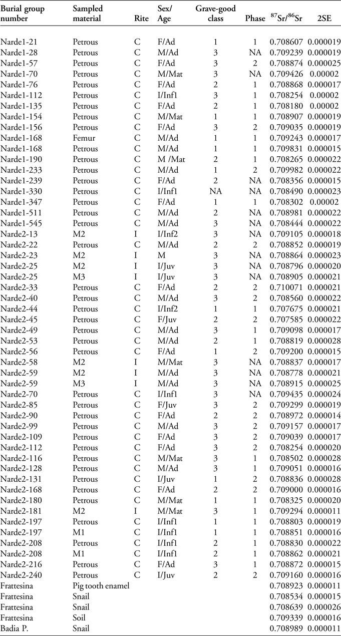
Two tests were performed on sub-adult burials Narde2-197 and Narde2-208 to verify the correspondence between the 87Sr/86Sr values measured on petrous portions and first molar crowns. Encouragingly, in both cases, the values are very similar (0.708803 and 0.708851; 0.708830 and 0.708862), thus confirming that the petrous portion represents a good indicator of childhood origin (Harvig et al. Reference Harvig, Frei, Price and Lynnerup2014). The inhumations with both M2 and M3 (burials Narde1-25 and Narde2-59) show no significant shift in the strontium isotope composition in the two phases of life represented by these molars.
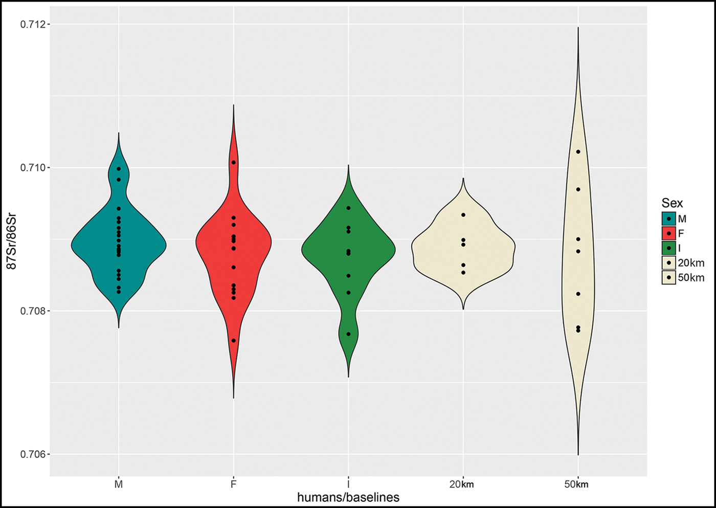
Of the 46 analysed individuals, 29 (63 per cent) are compatible with the 0–20km range 87Sr/86Sr baselines (0.70853–0.70934) surrounding Frattesina, while the other 17 (37 per cent) are incompatible (Figure 5). The strontium isotope ratios of these ‘outsiders’, however, fall within the 20–50km range baseline (0.70772–0.71022), with only two exceptions (Narde2-44 and Narde2-45), which fall just below this range. While the community of Frattesina therefore appears to have been largely ‘local’, it included a significant number of people from the broader hinterland—potentially from both north and south of the Po River. The patterns of mobility among males and females do not differ significantly. Notably, some sub-adults—despite their young age—also moved to Frattesina, where they died within a few years of arrival (unless their cremated remains were brought from elsewhere). This probably indicates that mobility involved entire family groups, not only individuals.
Violin plot of strontium isotope ratios for baseline samples (for references, see Table S1) and humans grouped by sex/age category (M = adult male; F = adult female; I = indeterminate sex, sub-adult). Each dot represents a single individual/baseline sample, and the width of the outer curve represents the kernel density of the distribution.
Diachronic variations in the percentage of non-local individuals may reflect the transition from an early stage, in which immigrants contributed to the growth of the settlement, to a phase of stabilisation and internal growth, with only a few newcomers to maintain the relationship with the hinterland; for example, through intermarriage, fosterage practices or other forms of social relationship (Figure 6: top). The rare inhumations are all compatible with the 0–20km baselines, while cremated individuals represent more widespread origins, both local and from a broader radius (Figure 6: bottom).
Violin plots of strontium isotope ratios of baseline samples (for references, see Table S1) and humans grouped by chronological phase (top) and type of funerary ritual (bottom). NA refers to burials that could not be assigned to a specific chronological phase.
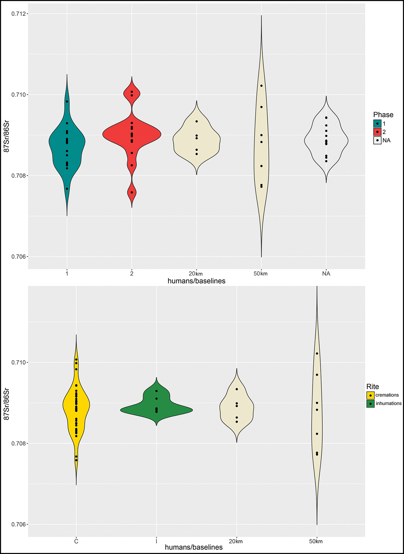
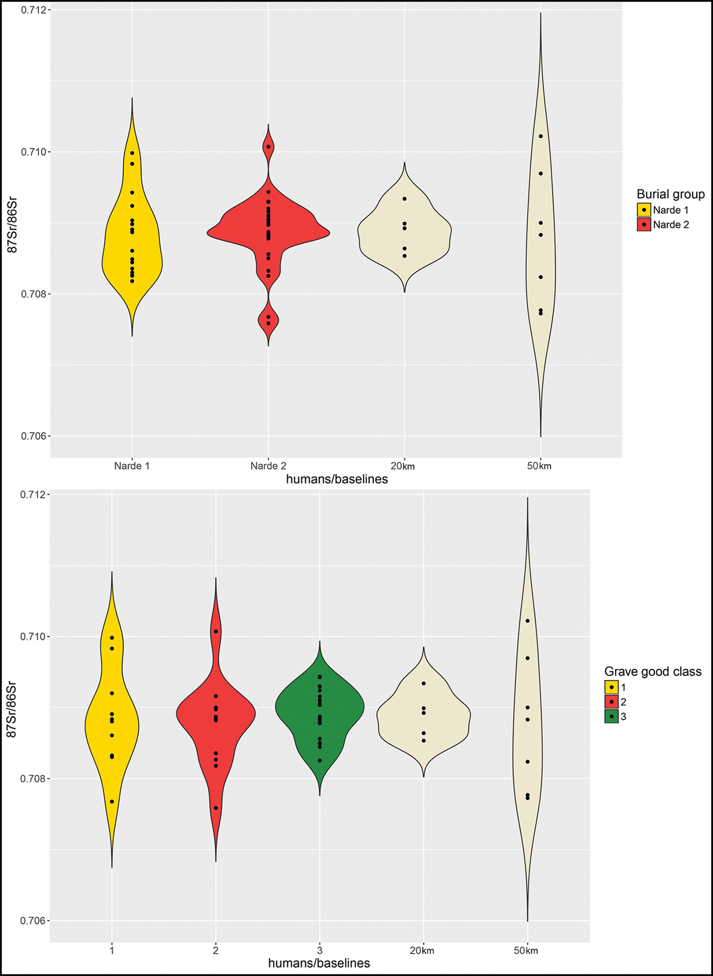
The grouping of 87Sr/86Sr values by burial ground (Narde 1 and 2) and grave-good class identifies further important distinctions. While Narde 2 individuals mainly concentrate within the interval of the local strontium isotope ratio—except for a few outliers (15 per cent), the Narde 1 group includes a higher proportion of people of different origins (33 per cent), although this latter group are all compatible with origins in the broader hinterland (Figure 7: top)—including Narde1-154, marked as a warrior by the presence of sword rivets (Figure 7: top). Considering the grave-good classes (Figure 7: bottom), mobility is more evident among the ‘richer’ burials (classes 1 and 2), while class 3 burials are mostly of individuals of local origin.
Violin plots of strontium isotope ratios of baselines (for references, see Table S1) and humans grouped by burial area (top) and grave good classes (bottom).
The concentration of non-local individuals amongst Narde 1 burials could also provide an explanation for the anomalously high proportion of adult individuals—mostly males—buried in this sector. The Narde 2 sector may be characterised as representing a local, kinship-based population, while the more privileged social groups of Narde 1 show a greater degree of mobility—and therefore tend to incorporate more non-local adults. From this perspective, growing social inequality may have triggered mobility, both among the members of the elite themselves and in the subaltern classes, the latter now probably more strongly tied to the elite by constraints of power and economic bonds than in the past. Thus, our analyses document the extent to which social inequality and mobility were interconnected in the Late Bronze Age, and the geographic scale of the social network, at least in relation to the flow of people. On the one hand, for a well-placed community to participate in the ‘global’ arena of trade, maintenance of the socio-political order in the polity's territory was decisive; on the other hand, wealth and prestige derived from trade probably reinforced this position of power.
Mobile elites and the ‘warrior-chief’ at Frattesina
As noted above, the individual in burial Narde1-168 may have achieved the status of a ‘warrior-chief’, as symbolised by the presence of an Allerona-type sword (Bianco Peroni Reference Bianco Peroni1970). This was ritually broken and deposited in pieces inside the grave, along with a bronze pin, a pair of tweezers and other ornaments (Figure 8). For this individual, identified osteologically as an adult male, we analysed both the petrous portion as an indicator of childhood origin, and the femoral cortical bone as a possible proxy for the place where he spent his last years of life. The former yielded a strontium isotope ratio (0.70983) that is incompatible with the local 0–20km baseline (Table 3), but fits within the 20–50km range. By contrast, the value obtained from the femoral cortical bone (0.70924) is consistent with the local range of Frattesina. This means that this individual moved to the site after early childhood—possibly during youth or early adulthood—and he probably spent the last years of his life there, at the apex of the community.
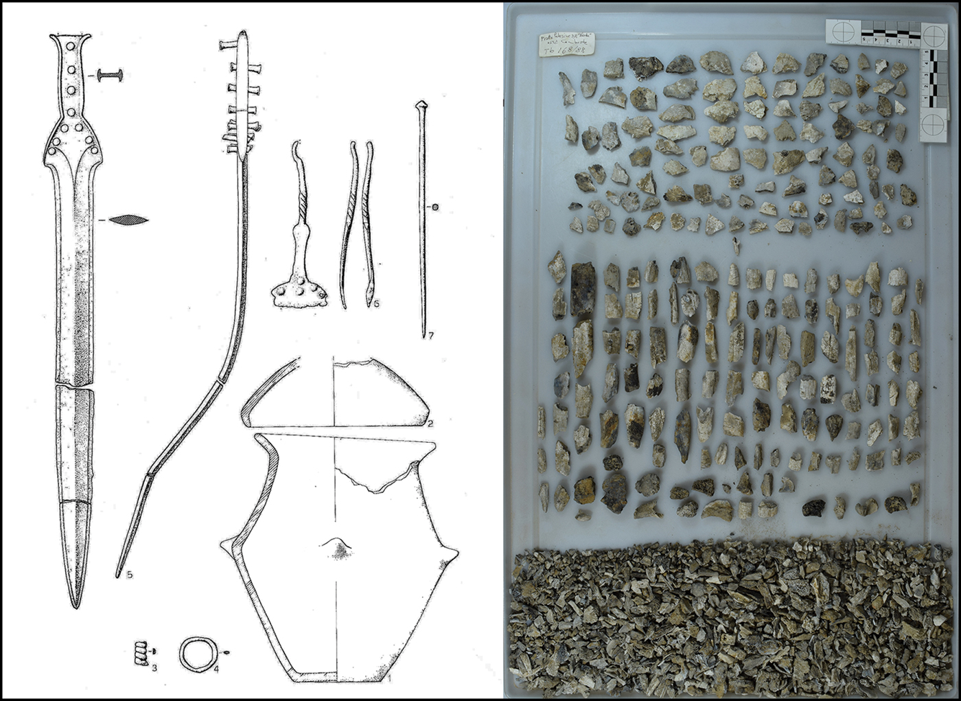
The grave goods and cremated bones of burial Narde1-168 (after Salzani Reference Salzani1989). Urn height is 0.26m, sword length is 0.46m.
Assessing the provenance of an individual through strontium isotope analysis alone is not straightforward, as different locations can be characterised by similar ratios. Our interpretation considers only the closest possible places of origin. The nearest geolithological zone in northern Italy with the closest 87Sr/86Sr baseline to Frattesina is, however, the easternmost part of the Verona plain, approximately 50km to the west. In particular, the baselines from the Middle–Late Bronze Age terramara at Fondo Paviani/Scalvinetto (0.7097–0.7101; Cavazzuti et al. Reference Cavazzuti, Skeates, Millard, Nowell, Peterkin, Bernabò Brea, Cardarelli and Salzani2019a) seem to correlate with the ratio obtained from the petrous portion of burial Narde1-168.
Marshall Sahlins (Reference Sahlins1981), in his famous article ‘The stranger-king: or Dumézil among the Fijians’, compares the dynamics of power in the Fiji Islands to the Indo-European tradition, arguing that human societies tend to locate power as originating from the outside (Sahlins Reference Sahlins1981, Reference Sahlins2008; see also Ling & Rowlands Reference Ling, Rowlands, Ling, Skoglund and Bertilsson2015). Sahlins focuses on origin myths across ancient polities in the Indo-European language area, which systematically feature a dichotomy between what the Romans called gravitas and celeritas. The former refers to the conservative, peaceful and productive character of an established native community, while celeritas represents the disruptive, transformative violence personified in the stranger king, who “erupts upon a pastoral scene of peaceful husbandry and political equality (or at least limited authority)” (Sahlins Reference Sahlins1981: 112).
The individual buried in grave Narde1-168 at Frattesina was probably neither a true ‘king’, nor a true ‘stranger’. Despite its uniqueness, his grave resembles those of the rest of the community and is included within a large collective—or at least not evidently exclusive—burial mound. ‘Warrior-chief’ perhaps would be a more appropriate definition for this individual. Moreover, his place of origin was not so distant as to define him as a ‘stranger’. Nonetheless, Sahlins's archetype of the ‘stranger-king’ evokes the power of alterity; burial Narde1-168 perfectly embodies celeritas, which breaks with the gravitas of the former Terramare tradition and guided whatever survived the collapse towards a new social model.
Since the discovery of Frattesina and its cemeteries, Italian scholars have debated the mechanisms underlying the origin and economic success of the settlement, and the degree of foreign (i.e. Cypriot and Levantine) involvement in this process as suggested by archaeological finds (Cupitò et al. Reference Cupitò, Leonardi, Longa, Nicosia, Balista, Corso and Kirleis2015). The new isotopic data presented here demonstrate that even though some individuals may have come from the Levant—where the available 87Sr/86Sr baseline ranges from 0.7079–0.7086 (Sheridan & Gregoricka Reference Sheridan and Gregoricka2015; Gregoricka & Guise Sheridan Reference Gregoricka and Guise Sheridan2016)—or were from other exotic places, they nonetheless represent a minority of the population and, in any case, not the upper elite. The latter appear quite mobile, although probably from within the broader hinterland radius.
Conclusions
Recent advances in mobility studies, isotopes and ancient DNA have revived the interpretative tensions between the paradigms of migration and local development. The current results from Frattesina display a complex pattern, in which regional mobility, territorial organisation, socio-economic growth and political power are deeply intertwined. We may infer that mobility patterns during Frattesina's formative phase are compatible with the local and regional dynamics of an area, concurrent with a phase of political re-organisation. Through a system of alliances, the nascent elite of Narde 1, which was less reliant on traditional kinship ties than the population represented by Narde 2, extended its influence over wider territories. Thus, Frattesina developed as a recognised partner in long-distance trade networks, inheriting the role previously held by centres such as Fondo Paviani—a legacy that might also have included a degree of elite transfer from the latter, as tentatively suggested by the isotopic evidence.
With regard to the concept of elite mobility, the rich ensemble of myths concerning the origins of Rome demonstrates that, at the formative stages of a new centre, even an outsider could rise to the apex of political power. The legend of Titus Tatius, the king of the Sabines, tells how, as a result of the chain of events generated by the rape of the Sabine women, he reigned over Rome with Romulus for five years (Carandini Reference Carandini2010). Beyond the historicity of the character, the story of Titus Tatius offers an example of Sahlins's concept of new powers (or allies) coming from outside, and accounts for the varied origins of Rome's first lineages, even at the highest social levels. The evidence presented here suggests that a similar scenario may have played out at Frattesina.
Acknowledgements
The strontium isotope analyses presented in this paper were conducted in the context of the Marie Skłodowska-Curie Action ‘Ex-SPACE’ (‘Exploring Social Permeability of Ancient Communities of Europe’, number 702930), funded by the European Commission.
Supplementary material
To view supplementary material for this article, please visit https://doi.org/10.15184/aqy.2019.59


 Open access