


Introduction
The ancient ruins known as Darazya are located 100km west of Alexandria on the coast of the Arab's Gulf (Figure 1). They are interspersed today with impressive Second World War structures from the Battle of El-Alamein. The remains of Greco-Roman buildings, corresponding with the location of Darazya, were mentioned by early nineteenth- and twentieth-century travellers to the Mediterranean coast of Egypt. References to the port of Derhis, made by ancient authors such as Strabo (Geographia 17.1.14; Jones Reference Jones1949), Claudius Ptolemaeus (Geographia 4.5.6; Müller Reference Müller1901) and the author of Stadiasmus maris magni (Müller Reference Müller1855: 427–514), may also refer to the site. The most complete descriptions of the area come from Jean Raimond Pacho, who travelled there in 1824 (Pacho Reference Pacho1827: 13–18), and Anthony De Cosson's account more than a century later (De Cosson Reference De Cosson1935: 123–26). Both mention the nearby tombs of El Qassabat el Gharbiya that still exist today, while De Cosson also describes the neighbouring remains of an ancient town that he identifies as Leukaspis, corresponding to the present Marina el-Alamein site. Vestiges of ancient settlements located further east are also described, such as Plinthine (Redon et al. Reference Redon2023), Taposiris Magna and Marea (Gwiazda & Derda Reference Gwiazda and Derda2021). The research undertaken in Darazya in 2021 and 2022 fills a gap in the wider picture, extending knowledge of ancient settlement along the maritime and land routes between Alexandria and Cyrenaica.
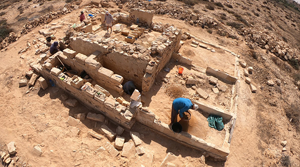
Location of the Darazya site in the Mareotis region (top) and a site plan (bottom) with highlighted structures: H1–H3 houses; C1–C2 cisterns; S shelters from the Second World War (drawing by S. Popławski).

The project aims to better understand the economic and civilisational importance of this densely populated region, with a focus on explaining the functioning, planning and culture of the small towns that drew on different traditions. Architectural studies, stratigraphy and anastylosis (reconstruction using original materials) will enable a better reading and understanding of how ancient structures were arranged. Interpretation of artefacts will help to comprehend the role of specific rooms or buildings and to determine how households functioned. By exploring one of the well-preserved Second World War structures, we can also answer questions about the organisation of the Battle of El-Alamein and construction techniques of the allied forces.
While securing the site during the construction of a tourist resort, Egyptian archaeologists uncovered house H3, part of house H1 and cistern C1. Above all, the aim of the current work is to explore and conserve the structures and to understand the topography and character of this surviving part of the settlement.
Results
The first season of work focused on analysing and valorising the site in terms of the requirements of future conservation and exhibition, as well as research. In the subsequent season, architectural, archaeological and technological investigations were undertaken, and the conservation began.
The main features are vestiges of an ancient settlement (Figure 1)—residential houses, other above-ground structures and two large underground cisterns—and Second World War monuments. Among the remains of the ancient settlement, the outer walls of the habitation-sized buildings dominate. The walls of three structures are more clearly defined, with remains reaching a height of up to 1.6m (Figures 2 & 3).
Remains of House H1 undergoing conservation (photograph by P. Zambrzycki).

Plans of the structures H1–H3 (drawing by S. Popławski).

House H1 appears to have functioned as an oikos-type residential house—organised around a main reception hall. To the west of the hall is a stairwell and to the south are three interconnected rooms. Two entrances from the north lead to the main hall and the stairwell from the rest of the house, the full extent of which remains undetermined.
House H3 is also an oikos-type dwelling, with a main reception hall to the south opening onto a courtyard surrounded by four smaller rooms. House H2 appears to have had a function beyond residential use. The most extensive building visible today (H2) is located in the centre of the site and consists of three main interconnected rooms. An in situ fragment of a column anticipates the discovery of developed layouts on the site.
The main walls of the houses were constructed using rubble masonry, bonded with clay and plastered with lime mortar. Some walls of limestone ashlars are also preserved. Internal partitions were built with stone slabs, while the floors were made from either limestone slabs or rubble.
Two large underground cisterns with central rectangular pillars are carved into the limestone bedrock (Figure 4). These distinctive structures could only be accessed through narrow shafts from above. Each is about five metres high and quadrangular in plan, with walls (10.5–14.5m long) that were originally covered with hydraulic mortar. These well-preserved cisterns and channels provide a better understanding of the extensive water supply systems of the settlements in this semi-arid area.
The underground cisterns (C1 on the left and C2 on the right) (photographs by P. Zambrzycki & S. Popławski).

The plan and construction of houses H1 and H3 are similar to those of residences from the Marina el-Alamein site (Bąkowska-Czerner & Czerner Reference Bąkowska-Czerner, Czerner, Bąkowska-Czerner and Czerner2019: 28–29). Fragments of architectural decoration also feature geometrised forms, as at the Marina el-Alamein site, permitting an initial date estimate in the Hellenistic-Roman period. This date is supported by the archaeological surface survey and preliminary stratigraphic excavations in some rooms of house H1.
Surface pottery includes sherds of amphorae, cooking pots and frying pans, as well as imported a pareti sottili (thin-walled) bowls. Of note are numerous fragments of good-quality Cypriot sigillata. House H1 contains material from the first–second centuries AD. Other finds include fragments of small, decorated stone altars (Figure 5) and cornices, possibly from cult niches, which would suggest domestic worship.
This fragment of a stone altar is a surface find from a residential area (photographs by R. Czerner).

Numerous military structures from 1941–1942, when British Army units were stationed there, are also preserved at the Darazya site. The main monument is a complex of 17 underground shelters linked by corridors, with three entrances from ground level (Figure 6). These were built of limestone blocks and covered with reinforced concrete coatings.
The underground shelters from the Second World War (drawing by S. Popławski).

Conservation
On-site thermograms and material analyses were carried out to differentiate between the types of stone and mortar used. This is important for the conservation that has begun, which includes wall protection, local filling, coping and partial anastylosis. These measures will also enhance the legibility of the remains.
Conclusion
The 2021 and 2022 seasons confirmed the considerable historical value and research potential of the site. After conservation, the site is sure to become a regional tourist attraction and it is anticipated that it will be possible to establish routes for visiting the site, moving between the ancient Mediterranean and the Second World War.
Acknowledgements
We would like to express our gratitude to the authorities of the Egyptian Ministry of Tourism and Antiquities, as well as those in the Marina Archaeological Area for their generous help and support. This article represents the completion of the work that Grażyna Bąkowska-Czerner and her late husband Prof. Rafał Czerner (the founding director of the Polish-Egyptian Conservation Mission El Darazya – Marina el-Alamein) were engaged in at the time of his passing. It is dedicated to his memory.
Funding statement
Wrocław University of Science and Technology fund the research.


 Open access