


Introduction
With the death of Charlemagne in AD 814, and the accession of Leo V the Armenian to the throne in Constantinople the previous year, the Carolingian and Byzantine Empires were at a crossroads. A third power, however, was gradually gaining strength: the Bulgarian Empire. The ambitions of pagan Bulgaria were clearly declared with the defeat of the Byzantine army in the Varbitsa Pass in AD 811, and through Khan Krum's subsequent plan to conquer Constantinople (Zlatarski Reference Zlatarski1970: 333–37 & 360–62). Krum's sudden death in AD 814 thwarted this plan, however, and his successor, Khan Omurtag, dramatically changed policy by concluding in AD 815 a 30-year peace treaty with the Byzantine Empire and redirecting the efforts of the young Bulgarian Empire in another direction. Economic resources were mobilised to upgrade and strengthen the state (Andreev Reference Andreev1994: 37–40). Wooden and earthen fortifications, for example, were replaced in stone, and state centres and residences, such as Pliska, Drustar and the Aul of Omurtag, near the village of Khan Krum, were completely rebuilt (Rashev Reference Rashev2008: 49–119). A column with a commemorative inscription, discovered at the Palace of Omurtag, provides evidence of the founding of the Aul at Ticha in AD 822, later called Veliki Preslav (Uspenskiy & Shkorpil Reference Uspenskiy and Shkorpil1905: 544–54, tab. CXVII, 3, 4) (Figure 1).
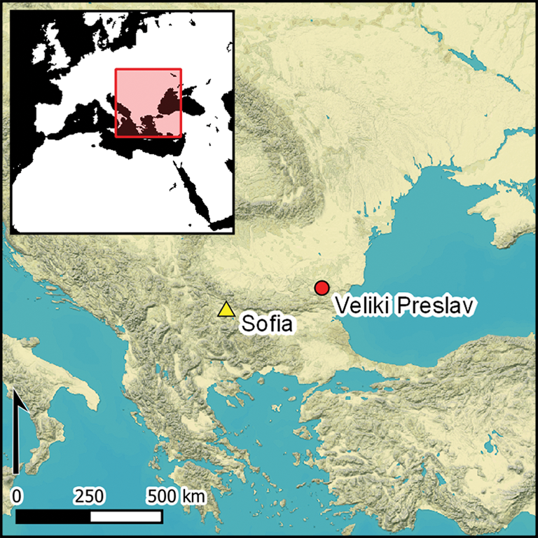
Map showing the locations of Veliki Preslav and important contemporaneous sites, alongside modern political borders and main rivers (figure by the authors).

Veliki Preslav: historical sources and archaeological excavations
The Bulgarian emperor, or tsar, Simeon I the Great (AD 893–927) transformed the Aul at Ticha from what was originally a fortification guarding the passes through the Balkans into a new capital for the First Bulgarian Empire (AD 681–1018), after Pliska. Consequently, the city represents the rise of the Bulgarian state and its material and spiritual development in the ninth and tenth centuries AD—a symbol of the Bulgarian Golden Age (Bozhilov Reference Bozhilov1983). In fewer than 80 years (AD 893–971), the site grew rapidly from a military fortress of 14.6ha into a vast, three-part urban centre consisting of an Inner City of 24.3ha, an Outer City of more than 300ha, and suburbs of up to 2500–3000ha (Bonev Reference Bonev and Rashev1995: 175–89). At its peak, Veliki Preslav was comparable in size to other contemporaneous cities, such as Constantinople and Baghdad.
V. Zlatarski conducted the first archaeological excavations at Veliki Preslav in 1897, which have since been continued by several generations of Bulgarian and foreign researchers (Bonev et al. Reference Bonev, Slavov, Goryanova, Goryanova and Grozdanova2019). A number of important structures have been discovered, including complexes associated with the emperor and church patriarchy, aristocratic houses, production centres and monasteries, and numerous churches. There is also considerable evidence for activity in later periods, after it had ceased to be a capital: Byzantine (AD 971–1040); Late Nomads (eleventh to twelfth century AD); and Second Bulgarian Empire (twelfth to fourteenth century AD). Despite nearly 125 years of regular archaeological excavation, more than 90 per cent of the city remains to be investigated. Several questions therefore still require answering: does the entirety of the Inner City consist of stone architecture? What is the density and structure of settlement in the Outer City and what types of features are located there? Can we define functionally specific areas? And to what extent can any newly identified structures help us understand features of urban life, such as transport infrastructure, economic activities or the social relationships of the population? In this article, we present the results of a large-scale geophysical survey of Veliki Preslav intended to answer some of these questions, at least in part.
Survey methods
Our approach combines geophysical investigations with the results of previous excavations and surface (fieldwalking) surveys. Geophysical investigation offers the ability to explore large areas by non-destructive means (Scollar et al. Reference Scollar, Tabbagh, Hesse and Herzog1990; Clark Reference Clark1996; Gaffney & Gater Reference Gaffney and Gater2003; David et al. Reference David, Linford and Linford2008; Campana & Piro Reference Campana and Piro2009; Schmidt et al. Reference Schmidt2016). Given the nature of the excavated archaeological structures at Veliki Preslav, which include stone buildings and wood/clay features, we conducted both ground-penetrating radar (GPR) and magnetometer surveys. While magnetometry can be used to survey large areas quickly and is able to identify a wide range of archaeological features, GPR can provide an estimate of the depth of these features. We also hoped that geophysical survey of the site would detect features, such as fire pits and destruction layers, due to thermoremanent magnetisation (Le Borgne Reference Le Borgne1960), as well as hoards and individual iron objects. Sunken features containing secondary fills of darker soils, which can incorporate both organic remains and magnetic minerals, can also be easily detected (Fassbinder & Stanjek Reference Fassbinder and Stanjek1993; Fassbinder Reference Fassbinder2015). The remains of stone architecture (predominantly limestone at Veliki Preslav) and fortifications, such as ramparts and ditches, should also be easily detectable. The detection of graves, however, can be difficult.
The GPR survey covered 1.44ha of the Inner City (Area 1) (Figure 2). Survey was conducted using a Raptor–45 multichannel georadar (Impulse Radar, Sweden) with eight antennas, using a central frequency of 450MHz. Measurement resolution was 0.1 × 0.1m. Data were processed using GPR Slice software (v.7MT, Geophysical Archaeometry Laboratory/Screening Eagle).
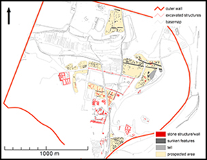
Plan of Veliki Preslav, showing surveyed areas. Excavated structures mentioned in the text are labelled (data sourced from Maxar; figure by the authors).

The magnetometer survey was conducted across part of the Inner City (Area 1), as well as in four separate areas of the Outer City (Areas 2–5). The total surveyed area was 24.2ha (Figure 2). The magnetometer survey used a LEA MAX fluxgate gradiometer (Eastern Atlas, Germany) with 10 fluxgate probes (FEREX CON 650, Foerster, Germany). Sampling density was 0.5 × 0.1m. Data positioning was provided using an RTK GNSS (Real-Time Kinematic Global Navigation Satellite Systems) and resulting data were processed using standard procedures in Eastern Atlas LEAD2 software (v2018). Measurements were interpolated to a raster format (cell size = 0.25 × 0.25m).
Geophysical measurements were processed and further visualised using ArcGIS (ESRI ArcMap v10.8). Anomalies interpreted as features with archaeological potential were digitised as vectors. Based on their physical properties—shape, dimensions, context and distribution in space—anomalies were classified as specific archaeological features, such as sunken houses, trenches, burnt features, fortifications and stone architecture. It should be stressed, however, that the classification of these magnetic anomalies involves interpretation, drawing on all available archaeological background information (Fassbinder Reference Fassbinder2015). Consequently, some of the anomalies interpreted as archaeological features may not be of anthropogenic origin.
Results
Inner City (Area 1)
Area 1 is situated within the Inner City walls and is divided in two by a modern road (Figure 2). Results from the magnetometer survey indicate disturbance across the entire area. Based on excavation records, these strong magnetic variations relate to a 0.1–0.5m-thick layer of stone debris from collapsed buildings (Vaklinova et al. Reference Vaklinova, Shtereva, Dimitrov, Manolova-Voykova and Gyurova2011: 407). Nonetheless, it is possible to identify several subsurface structures (Figure 3). Primarily, these relate to linear features with negative magnetic values, which may pertain to stone walls. Most are identified by long, straight lines that are often perpendicular to each other. Thinner linear features (0.7–1.4m) are suggested to represent the outlines of buildings and the perimeter walls of courtyards, while thicker features (approximately 2m) possibly relate to fortifications. Several buildings were thus identified, including some with narrow walls delineating internal spaces. Clearly defined rows of what appear to be uniform connecting rooms also can be observed (Figure 3: structure 2). Based on excavated examples of similar structures near the fortifications of Veliki Preslav and other centres of the First Bulgarian Empire, such as Pliska (Dimitrov Reference Dimitrov and Rashev1995: 247–54) and the aul at Khan Krum village (Antonova & Dremsizova-Nelchinova Reference Antonova and Dremsizova-Nelchinova1981), these features are interpreted as so-called ‘chain’ buildings, which were used mainly as barracks. At Veliki Preslav, they are present in both the pre-capital (AD 822–893) and capital (AD 893–971) periods: two similar examples were built along the inner facade of the eastern and southern fortress walls of the earlier aul; another three are located either side of the southern wall of the Inner City (Changova Reference Changova1957: 233–72; Vitlyanov Reference Vitlyanov2004); and a further example is found inside the Inner City's eastern wall.
Veliki Preslav: Inner City (Area 1), showing the results of the geomagnetic survey (top) and its archaeological interpretation (bottom). Numbered structures mentioned in the text are labelled accordingly (figure by the authors).

Two free-standing buildings, one of which features two rows of rooms, have also been discovered to the north and south of the so-called ‘Square with Phiale’ (Bonev Reference Bonev1998). Chain buildings such as these may also have served a secular function, and they have been documented in association with several civil and monastic complexes in the Outer City and beyond, including Pod Manastira, Selishte, Cheresheto, Patleina, Tuzlalaka, Avradaka and Valkashina (Shkorpil Reference Shkorpil1930: 208–11; Ivanova Reference Ivanova1948: 13–64; Ognenova & Georgieva Reference Ognenova and Georgieva1955: 373–417; Vazharova Reference Vazharova1960: 393–405; Chaneva-Dechevska Reference Chaneva-Dechevska1980: 140–43; Totev Reference Totev1998). Judging by the location, orientation and overall correlation of the newly identified chain buildings to the general plan of the Inner City, we suggest that they date to the end of the ninth or the first half of the tenth century AD. Excavation is required to confirm the presence of these structures, their chronology and function.
Magnetically positive curved and sinuous lines represent possible roads. Of these, we can say with near certainty that there was a road leading from south to north-east, towards the gate in the north Inner City wall (Figure 3). A total of six roads (or alleyways) have been excavated within the Inner City and shown to be paved with stone slabs. Two of these connect the ‘Throne Palace’ with the north gate; one was associated with the initial aul, while the other was added with the extension of the Inner City. Another road is located south-east of the ‘Ruler's Church’ (Vaklinova et al. Reference Vaklinova, Shtereva, Dimitrov, Manolova-Voykova and Gyurova2013: 377–79 & fig. 2) and more link the area north of the ‘Square with Phiale’ with the building complexes to the north-west (Aladzhov Reference Aladzhov and Aladzhov2013). A final example, previously partially excavated, is located over the already demolished initial northern Inner City wall, which was apparently constructed after the latter's removal (Nesheva Reference Nesheva1979: 47–60).
Besides linear structures, several strong thermoremanent anomalies were detected. These are suggested to represent the interiors of buildings filled with fired material, such as roof tiles, floor tiles and pottery. Strong bipolar anomalies at the eastern edge of the survey area are modern in origin.
In comparison to magnetometry results, the GPR survey captured fewer anomalies in Area 1 (Figure 4). This was mainly due to soil conditions, which were dry, resulting in weakened penetration of the electromagnetic signal and low conductivity. In the western part of Area 1, the results indicate one significant linear anomaly, which is identical to the wall identified by the magnetometer survey. A larger number of features was identified in the eastern part of Area 1, where some walls correspond with the remains of buildings detected by magnetometry. The approximate depths of these remains fluctuate between 0.9m and 1.4m below the current ground surface. Other anomalies are apparent, but their significance is unclear, possibly due to a lack of contrast between subsurface materials.
Veliki Preslav: Inner City (Area 1). Comparison of the interpretation from GPR (left) and magnetometer survey (right) (figure by the authors).

Outer City (Area 2)
Area 2 is situated outside the north-west corner of the Inner City and consists of four individual fields (Figure 2). Unlike Area 1, there is no evidence of subsurface stone debris. A total of 328 anomalies were detected and interpreted as having archaeological potential. The majority are characterised by positive values. Most (n = 316) can be explained as pits of various function and date (Figure 5), of which two main types can be distinguished. The first includes household storage pits, middens and limekilns. Previous excavation demonstrates that these features usually have a regular round or oval shape, with a diameter of 1–1.5m. They generally date to between the eleventh and thirteenth centuries AD, while limekilns were constructed and used between the eleventh and twentieth centuries AD. The presence of these features within the Outer City is comparable with excavated areas of the Inner City, which demonstrate high concentrations of similar features; we therefore suggest a similar chronology (Dimitrov & Manolova-Voykova Reference Dimitrov, Manolova-Voykova and Popov2020: 1117–21). The second type of anomaly includes approximately 20 pits with larger dimensions and of irregular quadrangular, polygonal or oval shape. We assume these to be sunken huts, similar to those previously excavated in both the Inner and Outer Cities (Bonev et al. Reference Bonev, Rashev and Rusev2004; Shtereva Reference Shtereva2006: 63–73; Vaklinova & Goryanova Reference Vaklinova, Goryanova and Vagalinski2018: 456–59; Dimitrov & Manolova-Voykova Reference Dimitrov, Manolova-Voykova and Popov2020: 1117–21). It is difficult to suggest a chronology, however, though their sporadic occurrence and limited numbers suggest they are of a later date—perhaps the early post-capital period (the end of the tenth to beginning of the eleventh century AD).
Veliki Preslav: Outer City (Area 2). The results of the geomagnetic survey (top) and its archaeological interpretation (bottom) (figure by the authors).

Besides settlement pits, the survey detected two anomalies of high thermoremanent magnetism, possibly representing ovens or furnaces. We also detected anomalies with negative values—possibly limestone structures. The same interpretation is applied to the linear structure to the south. This is approximately 50m long and shares the same orientation as the buildings in the Inner City. Given its relatively regular rectangular shape, as well as its considerable length and the presence of partition walls (courtyards?), we offer two hypotheses for its use. The first is that it forms a workshop complex, or ergasterion, analogous to those already excavated, one of which is located immediately to the west, in the Pod Manastira. The other possibility is that it forms part of the fortifications, such as a garrison camp.
Outer City (Area 3)
Area 3 is situated around the north-east corner of the Inner City and consists of three individual fields (Figure 2). Magnetometer survey identified 462 potential archaeological features (Figure 6). Most (n = 390) are interpreted as settlement pits. These are predominantly round to oval in shape and approximately 6m2 in area. In the northern part of the eastern-most field we also identified a concentration of at least 22 rectangular anomalies, each approximately 17m2. These are suggested to represent sunken huts, which are concentrated in groups and sometimes arranged in rows. It is currently unknown whether these represent individual huts or are parts of more complex structures.
Veliki Preslav: Outer City (Area 3). The results of the geomagnetic survey (top) and its archaeological interpretation (bottom). Numbered structures mentioned in the text are labelled accordingly (figure by the authors).

Several linear structures were also identified in this area, mostly related to the pedological processes. Two, however, are orientated east–west and appear to be anthropic in origin. One is interpreted as a road (Figure 6: structure 1), which passes through an inhabited area in the northern part of the surveyed area; to the east, it bends around a stone building (Figure 6: structure 3). The second anomaly (Figure 6: structure 2) runs straight. This probably represents a fortification ditch in front of the Inner City. At the western edge of this ditch, several strong thermoremanent magnetic anomalies are observed. These may indicate potentially burned structures, possibly of wooden construction.
In two areas, several negative magnetic anomalies were identified, indicating the presence of stone structures. At least four buildings can be identified in the north-eastern of these two areas. One measures 7 × 11m and is orientated east–west (Figure 6: structure 3). The other three are long, rectangular structures, measuring 5 × 37m, 4 × 16m and 5 × 16m, respectively, and are comparable to the chain buildings built en masse during the capital period. Of the at least two structures identified in the south-eastern area, one consists of several walls, an ‘apse’ and a stone foundation for columns (Figure 6: structure 4). This structure, which is only partially visible, is approximately 20m wide. The location and orientation of the apse does not necessarily imply its interpretation as part of a church, and the date and function of the building are unknown. The same applies to the complex of other stone buildings in the south-east.
A distinct structure, consisting of numerous strong anomalies detected along the eastern edge of the survey area, requires comment. These are undoubtedly the remains of prehistoric clay buildings on the western periphery of the Neolithic/Eneolithic tell, Gebe Klise (Gospodinov Reference Gospodinov1940: 154–55; Raduncheva Reference Raduncheva1967: 6; Georgiev & Dimitrov Reference Georgiev and Dimitrov2004: 79). The central part of the tell was destroyed in the third quarter of the ninth century AD, during the construction of the monumental basilica which carries the same name (Shkorpil Reference Shkorpil1930: 183–275). Most of the anomalies are of thermoremanent origin, with high magnetic values (over 100nT). Such strong magnetisation indicates a burning event, and it is likely that, at the end of the tell's final occupation, the fortification and dwellings attached to it were burnt.
Outer City (Area 4)
This area is situated in the southern part of the Outer City and consists of two individual fields (Figure 2). The results of the survey in the smaller field (south-west of Church No. 3 in Selishte; Shkorpil Reference Shkorpil1930: 197–98, tab. XVII) reveal it to be heavily disturbed by recent waste and building debris. The survey was insufficiently extensive to identify any patterns or structures that might indicate archaeological features (Figure 7).
Veliki Preslav: Outer City (Area 4). The results of the geomagnetic survey (left) and its archaeological interpretation (right) (figure by the authors).

In the larger field to the south, we identified 187 positive anomalies, which are interpreted as possible sunken archaeological features, most of which are probably settlement pits. They are primarily round or oval in shape and approximately 2–5m in diameter. In the southern part of this field, a concentration of approximately square anomalies was observed, each measuring around 3–5m. A similar, albeit smaller, concentration was detected to the north. These are interpreted as sunken huts. Overall, we detected at least 14 of these dwellings. In the northern part of this field we also identified two linear positive magnetic features, which might represent roads or pathways, given that they run parallel to each other and are respected by other anomalies (Figure 7).
Outer City (Area 5)
Area 5 is situated to the south of the Outer City wall, next to the North gate (Figure 2). Magnetometer survey identified 112 positive anomalies with archaeological potential (Figure 8). The majority (n = 109) are interpreted as settlement pits of various shape (primarily oval or round). In addition, we identified three bipolar anomalies, which we interpret as burned dwellings, or as ovens, furnaces, or other pyrotechnic structures.
Veliki Preslav: Outer City (Area 5). The results of the geomagnetic survey (left) and its archaeological interpretation (right) (figure by the authors).

The survey also revealed several linear features, the most prominent of which is a rectangular ditch system in the southern part of the survey area. The width of the ditches is estimated to be 2–5m, and the overall dimensions are 40 × 80m. Its shape and size are characteristic of the earthen (or possibly wooden) fortifications associated with early medieval military camps (Rashev Reference Rashev1982). The date of the feature—whether Old Bulgarian or Byzantine—is uncertain, but if it is a camp, it would be the first of its kind found in the territory of Veliki Preslav. Among the other linear features detected, one running parallel to the city wall in the northern part of the survey area is probably a road leading around the city's perimeter.
Discussion
Veliki Preslav features three well-defined cultural layers relating to the First Bulgarian Empire (ninth to tenth century AD), Byzantine rule (end of the tenth to eleventh century AD), and the Second Bulgarian Empire (twelfth to fourteenth century AD). These layers display characteristic building traditions, evidenced by specific architecture, infrastructure and production facilities (or the lack thereof). These features define: 1) a military fortress (AD 822–893); 2) a capital centre (AD 893–971); 3) a civil-craft town (AD 971 to mid eleventh century AD); 4) a nomadic settlement (mid eleventh to twelfth century AD); and 5) a rural village (twelfth to fourteenth century AD).
The surveyed areas of the Inner City indicate the presence of a regular road network and characteristic ‘chain’ buildings (Figure 9). Most of the latter structures are rectilinear and orientated along the fortified wall. The Inner City, like Pliska during its capital period, was a ‘closed’ area, and can be characterised as a ‘forbidden (or palace) city’, designed to shelter only the emperor and his entourage, the high clergy and the state administration, alongside their associated architectural complexes. No elements typical of medieval cities can be found within this area, such as residential neighbourhoods for craftspeople and merchants, nor any public architecture, such as squares or marketplaces. The first evidence for the presence of non-elites, in the form of craftworking, appears only in the early post-capital period, when, following its conquest by John I Tzimiskes (AD 971), the city became a strategic centre and was renamed Ioanopolis.
Plan of Veliki Preslav, showing significant archaeological features and new structures discovered using geophysics (figure by the authors).

The geophysical survey results indicate that the Outer City was also densely populated (Figure 9). Although there was some stone architecture, sunken huts were more typical. These appear to have been organised in rows, clustered together or loosely dispersed. Variations in the structure and orientation of some of these houses appear to reflect the road network, property boundaries and the topography of the site. So far, excavations indicate that during the ninth and tenth centuries AD, the site was occupied by large production complexes (in the Pod Manastira, Selishte and Kamenarya localities), monasteries (the Round Church and Cheresheto) and mansions of the civil and military aristocracy (Mostich). During the tenth century, these complexes spread beyond the fortified boundaries of the Outer town (e.g. to Byal bryag, Tuzlalaka, Avradaka, Valkashina and Patleyna). Except for a few sunken structures dated to the end of the tenth and the eleventh centuries AD, no consolidated settlement relating to the non-elite population of the capital period has yet been excavated at Veliki Preslav. The lack of settlement evidence for this period is corroborated by the dearth of cemeteries dating to the ninth to the tenth centuries AD. The newly discovered settlement structures may therefore relate to different periods. Some may represent neighbourhoods that appeared at the very end of the tenth and eleventh centuries, or even in the thirteenth century, especially as settlement dated to this period is usually accompanied by high numbers of pits (e.g. farm pits and middens).
When we compare the urban design of Veliki Preslav with the nearby, equally important site of Pliska, a number of parallels can be observed. As the presumed first capital of early medieval Bulgaria, Pliska also comprises an inner and outer city. Within the former, dozens of monumental stone buildings are enclosed by a massive stone fortification. Outside this wall, the huge settlement complex that comprises the outer city is protected by earthen ramparts. Various areas within Pliska have been excavated, including buildings associated with imperial, ecclesiastical, monastic and aristocratic groups (Aladzhov Reference Aladzhov and Aladzhov2013). Similar to Veliki Preslav, previous archaeological research has focused mainly on Pliska's inner city, and excavations of the outer city have predominantly targeted the visible remains of stone buildings (Dimitrov Reference Dimitrov and Rashev1995). Nonetheless, as at Veliki Preslav, large-scale geophysical survey at Pliska has contributed significantly to a wider understanding of the settlement (Henning Reference Henning and Henning2007; Filzwieser et al. Reference Filzwieser2019). Similarly, geophysical survey at Pliska has identified several types of building, including multi-room stone houses, often surrounded by numerous simple sunken huts. Similarly, there are areas devoid of permanent settlement at both sites. These may have served various purposes, the exact natures of which are currently unknown; however, we raise their presence here in respect of the ongoing debate surrounding empty space within settlement archaeology.
Veliki Preslav was one of the largest cities of its time and can be compared to other urban centres, such as Constantinople (approximately 1470ha; Magdalino Reference Magdalino and Laiou2002) and Pliska (approximately 2188ha; Aladzhov Reference Aladzhov and Aladzhov2013: 190). The specific layout of Veliki Preslav does not allow us to equate the boundaries of its fortified area (approximately 300ha) with the city's full extent. Many features, such as production and monastic complexes, and monumental Christian basilicas (Sakalova Mogila, Stambol Yolu), were located outside the walls of the Inner City but undoubtedly form part of the city's urban area. In terms of its fortified area, Veliki Preslav compares with the second largest Byzantine city of the Middle Byzantine period, Thessalonike, whose fortifications also enclosed an area of approximately 300ha (Bakirtzis Reference Bakirtzis and Henning2007). Veliki Preslav significantly exceeds the size of other centres in Western and Northern Europe at the time, such as Madīnat az-Zahrā’ (medieval Cordoba, 110ha; Arnold Reference Arnold2019), Anglo-Saxon Hamwic (45ha; Brisbane Reference Brisbane, Hodges and Hobley1988; Andrews Reference Andrews1997) or Danish Hedeby (24ha; Jankuhn Reference Jankuhn1986; Hilberg Reference Hilberg, Brink and Price2008). The centre of Frankish power in neighbouring Pannonia, Mosaburg (Zalavár-Vársziget), covers a fortified area of only approximately 10ha (Szőke Reference Szőke2020). The largest fortified settlement of Great Moravia, Břeclav-Pohansko, covers an area of only 52ha (Macháček Reference Macháček2010). The size of Veliki Preslav points to the cultural and political ambitions of Simeon, who made Veliki Preslav the capital of his empire in an effort to reconcile the Bulgarians with Constantinople (Bozhilov Reference Bozhilov1983: 55–56). From written sources, we know that, in many ways, he succeeded, and Veliki Preslav made a striking impression on its visitors (Mavrodinov Reference Mavrodinov1955).
Conclusions
Extensive geophysical surveys of the urban landscape of Veliki Preslav, the second capital of the Bulgarian Empire, significantly expands our knowledge of the settlement, its organisation, development and context. Previous investigations focused on the Inner City, limiting our understanding of the wider urban landscape. By conducting survey across all three elements of the site—the Inner City, Outer City and suburbs—we have expanded our knowledge of the site as a whole. Combining the results of our geophysical survey with previous excavations, we demonstrate that the Inner City was constructed entirely of stone and characterised by various residential and religious buildings. Despite the presence of empty space in the Outer City, it also appears to have been densely populated at some period. This is indicated by the various settlement features identified in all the surveyed areas. Stone architecture is found in smaller numbers. Wooden sunken huts are a dominant feature, surrounded by numerous settlement features of various function (e.g. workshops, storage pits). Roads suggest organised development in the area of the Outer City. The fact that this area of the city was spatially structured is also indicated by the discovery of a ditch that may not only have played a defensive role.
Given the specificity of its architectural plan and vast size, Veliki Preslav will remain a scientific challenge for decades to come. Non-destructive survey provides the opportunity to elucidate some of the various problems presented by its archaeology and can guide any future excavations. Indeed, such research is already underway. The results of the first large-scale geophysical survey of Veliki Preslav therefore represent a significant advance in our knowledge of this important early medieval European city.
Funding statement
This publication is based on research supported by the Ministry of Culture Czech Republik, programme NAKI III under Grant no. DH23P03OVV051 and by the Slovak Research and Development Agency, Contract no. APVV-19-0563.


 Open access