


Background
Situated on Lednica Lake, the island of Ostrów Lednicki and its early-medieval settlement complex constitute one of Poland’s most important archaeological sites. It was here that the foundations of Polish statehood were laid. In much of Europe, including the Piast state, island centres of power played a central role, often combining religious, political and economic functions. In the late ninth or early tenth century, a stronghold was built in the southern part of Ostrów Lednicki, and an internal stone palace and church were constructed in the second half of the tenth century. This undertaking has been directly linked to Mieszko I, the first ruler of Poland (Kurnatowska & Wyrwa Reference Kurnatowska and Wyrwa2016). It is highly likely that his son, Bolesław the Brave, the first king of Poland, was born on the island, c. 967, and oversaw further enhancement of the stronghold. Excavations at the site began in the mid-nineteenth century and have been ongoing ever since (Pydyn & Lewek Reference Pydyn, Lewek, Leighton, Różycki and Pranke2022).
The remains of two bridges, linking the island to the eastern and western shores of the lake, were discovered in the late 1950s and early 1960s, but systematic underwater archaeological research has been possible only since 1982, conducted by Nicolaus Copernicus University in Toruń. More than 40 years of underwater research have permitted a thorough analysis of three early-medieval bridges (Figure 1) and uncovered seven logboats and the largest collection of early-medieval weapons in Central Europe, comprising 141 axes, 50 spearheads, three fully preserved spears, seven swords and a helmet (Kurnatowska & Wyrwa Reference Kurnatowska and Wyrwa2016).
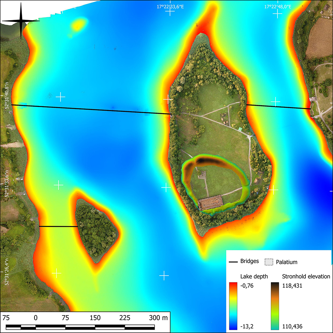
Map of Ostrów Lednicki with marked medieval hillfort, palace and bridges (figure by M. Popek).

Figure 1 Long description
A heat map of Ostrw Lednicki displays the lake depth and stronhold elevation. The map uses a color gradient to indicate varying depths and elevations, with red representing shallow areas and blue representing deeper regions. Bridges and a palatium are marked on the map. The lake depth ranges from -0.76 meters to -13.2 meters, while the stronhold elevation ranges from 110,436 to 118,431. The map includes geographical coordinates and a scale for distance measurement.
The eastern bridge was 187m long, the western 438m long, and both were around 5m wide. They were erected on piles and yoke beams in the 960s and rebuilt several times until the 1030s (Kurnatowska Reference Kurnatowska2000). Sessile oak (Quercus patraea) was used for the bridges, selecting trunks up to 14–15m long and 120–220mm in diameter (Kola & Wilke Reference Kola and Wilke2014). Non-invasive surveys and underwater prospection carried out in 2017 revealed another bridge, which actually turned out to be two bridges running along the same course. These crossings connected the neighbouring Ledniczka island with the western shore of the lake. The bridges were dated to the beginning of the tenth century and the turn of the fourteenth century, respectively (Pydyn & Popek Reference Pydyn and Popek2020).
Methods
Underwater and terrestrial geospatial methods were first combined to create an accurate map of the area: a multibeam echosounder provided a bathymetric lake map, a sub-bottom profiler produced an image of sediments, and both airborne laser scanning and georadar were used to map surface topography. All data were completed with archival documentation and transferred to a GIS (geographic information system) environment, where they were combined and correlated. This has helped address research problems at the water/land border (Pydyn et al. Reference Pydyn, Popek, Janowski, Kowalczyk and Żuk2024).
Terrestrial and underwater trenches were then established along a shared axis near the palace (Figure 2) to examine the archaeological situation in both environments. To explore the uncovered relics with maximum accuracy, the same documentation standard was adopted on land as underwater. All exposed construction layers were documented photogrammetrically and linked together. Key elements were also documented three-dimensionally. Soil stability tests were carried out, and samples were taken from most construction beams for dendrochronological dating.
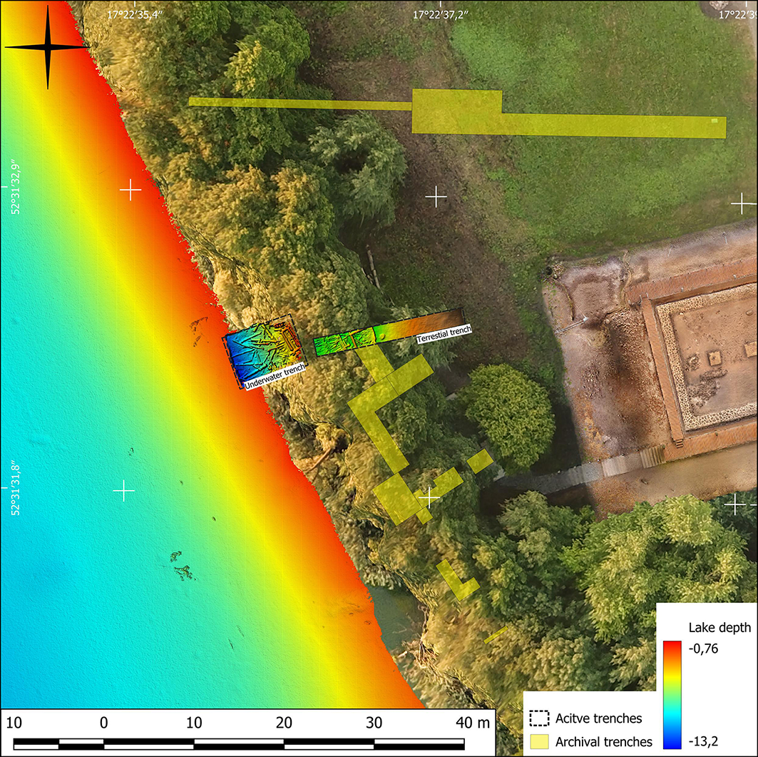
Western shore of Ostrów Lednicki island with marked archival and active archaeological trenches (figure by M. Popek).

Figure 2 Long description
A heat map of the western shore of Ostrw Lednicki island with marked archival and active archaeological trenches. The map shows a color gradient indicating lake depth, with red representing shallow areas and blue representing deeper areas. The depth ranges from -0.76 meters to -13.2 meters. The map includes labels for underwater and terrestrial trenches, with active trenches marked by dashed lines and archival trenches marked by solid lines. The trenches are distributed across the island and the adjacent lake area, with some extending into the water. The map also includes a scale bar and a compass rose for orientation.
Results
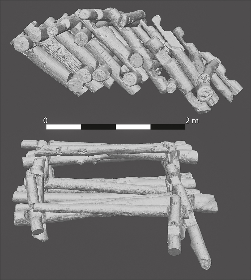
The excavations revealed part of a wooden fortification built at the end of the tenth century as part of a major undertaking by Mieszko I and Bolesław the Brave. The subsequent collapse of the structure is indicated by debris—structural beams and piles—found both underwater and on land. While upper layers of these elements are disorganised, influenced by post-depositional processes, a fallen box-construction wooden wall was uncovered below (Figure 3). Notched beams were stacked in a repeating box formation and the internal space was filled with stones and the remains of wood. It is difficult to determine whether the wall slipped (bottom first) or toppled (top first) into the water; ongoing geophysical survey will provide more information. The fallen boxes, which were recorded in the trench and trench profiles, had been strengthened with wooden piles, which were also documented in situ.
3D documentation of the remains of the hillfort construction collapse from Lake Lednica (figure by M. Popek).

Figure 3 Long description
The image presents a 3D model showcasing the remains of a collapsed hillfort structure from Lake Lednica. The model includes two views: an overhead perspective displaying a pile of logs and a side view illustrating a partially reconstructed log framework. The logs vary in size and are arranged in a manner that suggests the original construction of the hillfort. A scale bar at the bottom indicates measurements, with a length of 2 meters for reference.
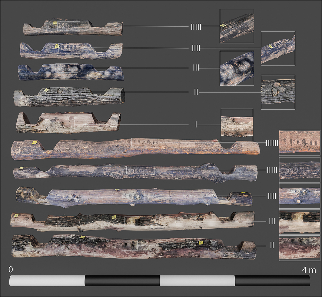
The wooden construction elements are preserved in perfect condition. They are made of either oak or elm and, in the lower layers of the excavation, bark remains on the beams. Incised markers, identified as numbers, are present on beams (Figure 4). The system of numbering beams, using incremental numbers of incisions from lowest to uppermost layers presumably to indicate to constructors the level at which each beam should be laid, is a unique find on an early-medieval site. The foundation beam was marked with the symbol ʌ. Dendrochronological dating suggests that this construction was erected in the final years of the tenth century.
The incremental numbers of incisions used to number the beams from lowest to uppermost layers (figure by M. Popek).

Figure 4 Long description
The image presents a detailed illustration of wooden beams from an archaeological site, each marked with incremental numbers of incisions to indicate their position from the lowest to the uppermost layers. The beams are arranged vertically, with close-up views of specific sections highlighted to show the incisions in detail. This illustration is part of an archaeological study of Ostrw Lednicki, an island on Lednica Lake in Poland, which is one of the country's most important archaeological sites. The site includes an early-medieval settlement complex and is linked to the foundations of Polish statehood. The stronghold on the island was built in the late ninth or early tenth century, with a stone palace and church constructed in the second half of the tenth century. These structures are associated with Mieszko I, the first ruler of Poland, and his son, Bolesaw the Brave, the first king of Poland. Excavations at the site began in the mid-nineteenth century and have been ongoing.
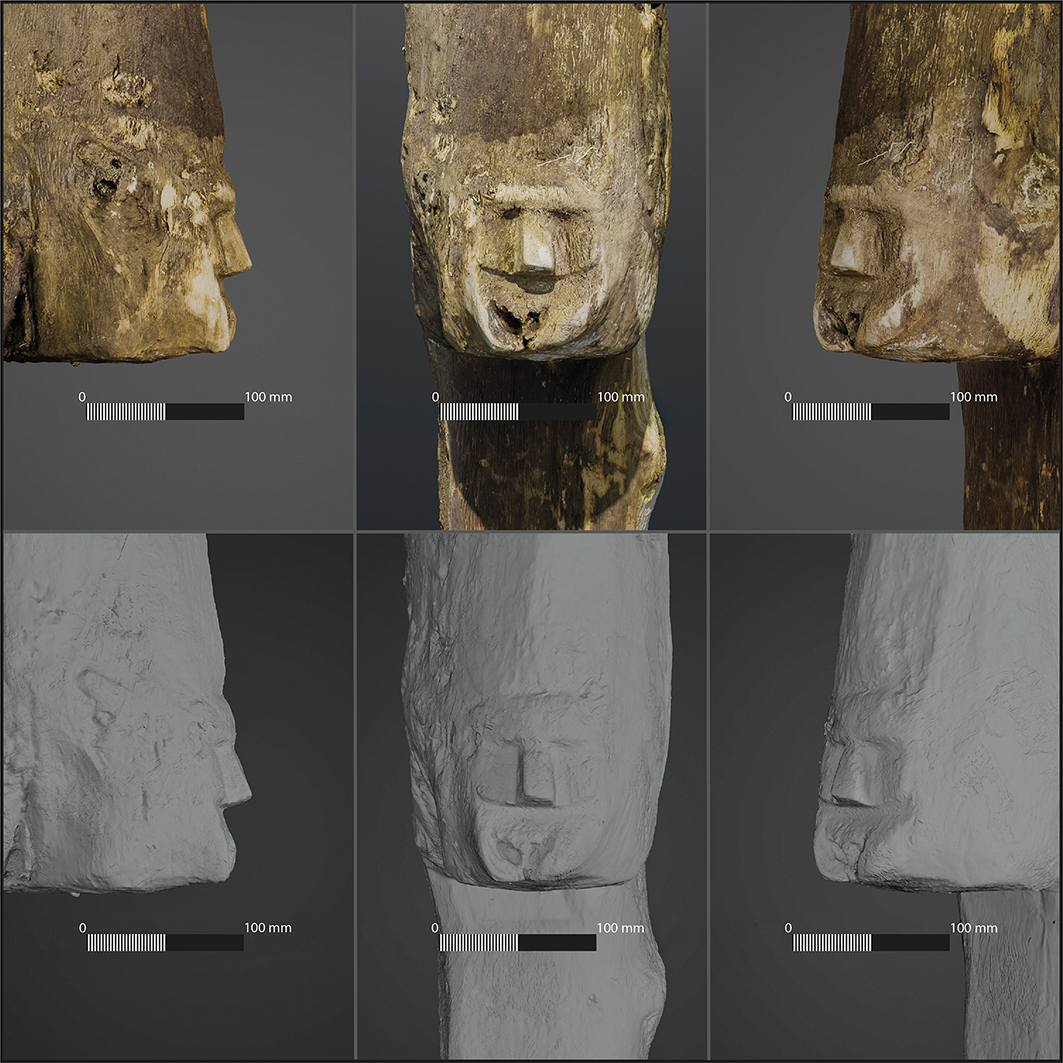
Only a few other artefacts were found in the immediate vicinity of the structure, predominantly ceramics and metal objects. A wooden hook, an important structural element with a less utilitarian human face carved on its surface (Figure 5), was encountered under the collapsed rampart structure. Dendrochronological dating of this element indicates that the tree for its production was felled in AD 967 (-7/+8 years). Figural representations from the Early Middle Ages are sporadic, with parallels found at other Slavic sites in Germany, Poland and Russia (Szczepanik Reference Szczepanik2020) (Figure 6). However, this object is unique for its detailed context, in situ documentation and absolute dating.
Representation of a human face on a construction element from the fortifications (figure by M. Popek).

Figure 5 Long description
The image displays a human face representation on a construction element from fortifications. The face is depicted in three different views: left profile, front view, and right profile. Each view is shown in two versions: a colored photograph and a grayscale 3D model. The construction element appears to be made of wood and shows signs of wear and aging. The face has distinct features, including a prominent nose and lips, and is likely part of a historical or archaeological study.
Representations of the human face in figurative art at medieval sites in central and eastern Europe (figure by M. Popek & K. Lewek).

Figure 6 Long description
A map of central and eastern Europe showing various medieval sites where representations of the human face in figurative art have been found. Key locations marked on the map include Wolin, Lednica Lake, Riga, Fischerinsel, Veliky Novgorod, and Staraya Ladoga. Each location is associated with an image of a human face representation from that site. The map also includes surrounding countries and geographical features, providing context for the distribution of these artifacts across the region.
Conclusion
Ostrów Lednicki was important to the formation of the early Piast state and laid the foundations for the development of Polish statehood. Development of the island centre was a success story but a major construction failure was also experienced, resulting from ignorance of the underlying geology. However, this failure is fortuitous as it reveals nuances in the construction of the early-medieval defensive fortifications. The preserved structural element bearing a representation of a face is probably related to the symbolic sphere of the stronghold inhabitants. Statues are mentioned in written texts by Widukind of Korbea, Thietmar of Mersburg, Herbord, Helmold, Sakso the Grammarian, Ebo and Nestor (Szczepanik Reference Szczepanik2020). These narratives also reveal that human and animal images covered building walls and stood inside buildings as freestanding pillars.
Funding
The research is funded by the Museum of the First Piasts at Lednica and Nicolaus Copernicus University’s ‘Excellence Initiative – Research University’ programme.
Author Contributions: using CRediT categories
Andrzej Pydyn: Conceptualization-Equal, Formal analysis-Equal, Funding acquisition-Equal, Investigation-Equal, Project administration-Equal, Writing - original draft-Equal, Writing - review & editing-Equal. Mateusz Popek: Data curation-Equal, Formal analysis-Equal, Investigation-Equal, Methodology-Equal, Visualization-Equal, Writing - original draft-Equal. Konrad Lewek: Data curation-Equal, Formal analysis-Equal, Investigation-Equal, Project administration-Equal. Andrzej Kowalczyk: Data curation-Equal, Formal analysis-Equal, Funding acquisition-Equal, Investigation-Equal, Project administration-Equal.


 Open access