


Introduction
Histories of ancient empires often begin with a dated event—such as a decisive battle or coronation—that signals the growing dominance of a new dynasty. These foundational chronicles synchronise early regional records with the Gregorian calendar, promoting a sense of chronological precision that obscures the self-interest of ancient rulers, priests and state officials in recording their own past and present. As archaeology plays an increasingly active role in the reconstruction of imperial societies, many scholars still concede the accuracy of historical chronologies, which can seem more reliable and more precise than the ranges derived from scientific dating methods. Despite substantial improvements in sample processing and calibration in recent decades, research on ancient empires is just beginning to actively incorporate archaeological dates into the reconstruction of imperial expansion, administrative consolidation and decline (e.g. Brock & Terrenato Reference Brock and Terranato2016; Webster et al. Reference Webster, Smith, Dee, Hajdas and Schwartz2023). A robust radiocarbon chronology might not unseat dynastic calendar dates, but archaeologists can use it to situate royal biographies, state annals and other historical texts within a material context that can engage with different scales of change—from long-term climatic processes to local developments involving non-elite groups, families and individuals.
This article presents 18 new radiocarbon dates from a series of test excavations at Ak'awillay, the first large pre-Inca site excavated in the Xaquixaguana Valley, 20km west of Cuzco, the capital of the Inca Empire. The new dates indicate abandonment and reoccupation, encouraging the reinterpretation of regional settlement patterns and the ways in which Inca identity developed as rulers intervened in rural landscapes surrounding their capital. The occupation history at Ak'awillay adds nuance to the growing understanding of how group interactions contributed to Inca state development and imperial expansion, drawing attention to the value of radiocarbon dates for reconstructing social processes that are typically overlooked in the histories of imperial elites.
Radiocarbon dating and Inca origins
During the early sixteenth century AD, the Inca dynasty governed the largest empire in the pre-contact Americas, a realm that extended more than 1500km to the north and south of the Cuzco region in what is now Peru. Oral histories of Inca origins and imperial expansion were first transcribed during the Spanish colonisation of the Andes, but calendar dates for individual Inca reigns did not appear in these records until the 1570s, 40 years after Pizarro invaded the region. Until recently, most archaeologists dated Inca imperial expansion using a chronology derived from a 1586 Spanish chronicle (Rowe Reference Rowe1945), which uses 1438—the date given for the accession of the ninth Inca, Pachacuti Inca Yupanqui—to mark the start of conquests beyond the Cuzco region. For decades, the assumed precision of the historical timeline discouraged many excavators from processing radiocarbon dates; a 1996 compilation identified just 24 ‘imperial phase’ dates (Adamska & Michczyński Reference Adamska and Michczyński1996). Since then, the sample of Inca archaeological dates has grown steadily, and Bayesian modelling of dates from distant Inca sites in Argentina, Ecuador and the south coast of Peru now indicates an Inca provincial presence several decades prior to the chronicle dates (Marsh et al. Reference Marsh, Kidd, Ogburn and Durán2017; Valdez & Bettcher Reference Valdez and Bettcher2023).
The ongoing reassessment of Inca provincial chronologies complements archaeological research near Cuzco. Archaeologists have used radiocarbon dates from Machu Picchu—a country palace of Pachacuti Inca Yupanqui—to modify the dynastic timeline (Burger et al. Reference Burger, Salazar, Nesbitt, Washburn and Fehren-Schmitz2021; Ziółkowski et al. Reference Ziółkowski, Abuhadba, Hogg, Sieczkowska, Rakowski, Pawlyta and Manning2021; Lane & Marsh Reference Lane and Marsh2024). Augmenting this biographical approach, researchers working outside of royal estates emphasise how interactions between the Incas and the many named groups living in the Cuzco region during the Late Intermediate Period (c. AD 1000–1400) established Inca elite prominence and contributed to the expansion strategies used in campaigns of imperial expansion. Building on earlier research (Rowe Reference Rowe1944), a series of full-coverage pedestrian surveys employed the same field methods (a targeted 50m interval with purposive surface collections) to register approximately 1000 Late Intermediate Period sites and 1500 Inca-era (c. 1400–1530s) sites in the Cuzco area (Figure 1; Covey Reference Covey2014; see also Bauer Reference Bauer1999, Reference Bauer2004; Bauer et al. Reference Bauer, Silva and Hardy2022; Kosiba Reference Kosiba2010). The resulting settlement patterns indicate substantial variation in the Inca impact on local populations (Table 1). Under Inca rule, some areas became more hierarchical and populous, while others experienced a reduction in site counts and settled area. These distinct trajectories were undoubtedly influenced not only by the actions of Inca rulers, but also by local farmers and herders who engaged with the changing political climate while maintaining distinct cultural identities and pursuing subsistence practices tailored to dynamic landscapes.
Map of the Cuzco region showing areas covered by regional survey projects and the locations of sites mentioned in the text (figure by R. Alan Covey).

Late pre-Hispanic settlement changes in Cuzco subregions. LIP: Late Intermediate Period.

* Tier 1: <5ha; Tier 2: 5–10ha; Tier 3: 10–30ha; Tier 4: 50+ha. Sources: Bauer Reference Bauer1999, Reference Bauer2004; Bauer et al. Reference Bauer, Silva and Hardy2022; Covey Reference Covey2014; Kosiba Reference Kosiba2010.
The coarse-grained chronologies and settlement patterns developed by survey archaeology offer a context for excavations at large villages and towns associated with non-Inca groups mentioned in Spanish chronicles and archival documents, including the Pinagua, Mohina, Ayarmaca, Cuyo and Quilliscache. Site stratigraphies provide a more sensitive chronology, and artefacts from local households, tombs and public spaces offer perspectives on how individuals and families interacted with neighbouring groups, including the Incas. Horizontal excavations at Chokepukio (McEwan et al. Reference McEwan, Oviedo and Chatfield2005), Wat'a (Kosiba Reference Kosiba2010) and Pukara Pantillijlla (Covey Reference Covey2015) have investigated the largest pre-imperial sites in the Lucre Basin, the Ollantaytambo area and the upper Sacred Valley, respectively. Smaller-scale excavations at the centres of Minaspata (Hardy Reference Hardy2019) and Yunkaray (Quave et al. Reference Quave, Covey and Durand Cáceres2018) encountered artefacts and architectural remains and contributed additional radiocarbon dates.
More than 100 radiocarbon dates from Late Intermediate Period excavation contexts and standing architecture throughout the Cuzco region inform a group-oriented, regional synthesis of archaeology and the colonial chronicles. Although additional excavations are necessary to address the strategies of individuals and kin groups, research to date indicates general patterns that enable an understanding of the processes of Inca imperial expansion. Dates from prominent ridgetop villages indicate the early appearance of Inca-style buildings and material culture, and Inca-style pottery is associated with uncalibrated dates of 700–650 BP (or AD 1256–1417) at Ancasmarca, Wat'a and Pukara Pantillijlla (Kendall Reference Kendall1985: 332, 349; Kosiba Reference Kosiba2010: 236; Covey Reference Covey2015). These early Inca associations with decentralised agropastoral groups living in the uplands contrast with the persistence of non-Inca architecture and ceramic styles at large valley-bottom sites. At Chokepukio, McEwan and colleagues (Reference McEwan, Oviedo and Chatfield2005) identified construction and maintenance of non-Inca monuments as late as AD 1470. Excavations at the nearby site of Minaspata encountered a feature dating to 1424–1541, which Hardy (Reference Hardy2019: 327) interprets as evidence of the establishment of Inca sovereignty, while Quave and colleagues (Reference Quave, Covey and Durand Cáceres2018) identify late non-Inca floors at Yunkaray that date to 1404–1465. These large valley-bottom sites experienced substantial disruption with Inca conquest; Yunkaray and its surrounding villages were abandoned, and the population of Chokepukio was resettled and replaced by Inca colonists (McEwan et al. Reference McEwan, Chatfield, Oviedo, Isbell and Silverman2002). By the time the Incas oversaw this population displacement, they already ruled an empire that extended hundreds of kilometres beyond the Cuzco region.
Local groups in the Xaquixaguana Valley
Colonial chronicles offer limited details on groups living in the Xaquixaguana Valley, which lay just to the west of Cuzco (Figure 2). Francisco Pizarro and his Inca allies passed through the valley on their way to Cuzco in 1533, and Pizarro made lavish encomienda (Indigenous labour) grants to his brothers Hernando and Gonzalo soon after, listing several caciques and principales (local nobles and officials) and the towns in the valley that served them. These officials ranged from Abiacaxa, the principal of the small village (poblezuelo) of Yquico, to the cacique Curiara, “lord of the towns of Mayo and Sierra [Circa] and Tomebamba with all the natives and principales subject to them” (Platt et al. Reference Platt, Bouysse-Cassagne and Harris2006 [1540]: 290; our translation). Gonzalo Pizarro's encomienda included a cacique named Ancaipullo, who governed the town of Sanco. Although it is not possible to determine the Inca-era population of Sanco, 1572 tribute records list a population of 3877 individuals for the town and its outlying hamlets, which made annual tribute payments in maize, wheat, potatoes and Spanish sheep (Cook Reference Cook1975: 155–56).
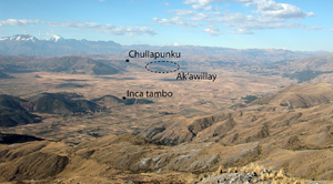
View of the Xaquixaguana Valley, facing north-east toward Cuzco (figure by R. Alan Covey).

Early Inca histories did not discuss local Xaquixaguana Valley populations. Juan de Betanzos (Reference de Betanzos and Hamilton1996: 27–38 [1550s], part 1, chapters 8–9) mentions a town called Jaquijaguana that supported the invading forces of the Chancas during the legendary battle that brought Pachacuti Inca Yupanqui to power. Another early writer, Pedro de Cieza de León, states only that the valley was once heavily populated (Reference de Cieza de León1553: chapter 91). Drawing on the testimony of elite Inca men, sixteenth-century Spaniards paid little attention to how individuals from Xaquixaguana Valley groups interacted among themselves, or with Inca elites, before or during the imperial period. One exception was the town of Anta, whose elite women convinced their male relatives to forge an alliance with the Incas that was consolidated through the marriage of a local woman, Mama Runtucaya, with the eighth Inca, Viracocha Inca (Sarmiento de Gamboa Reference Sarmiento de Gamboa, Bauer and Smith2007 [1572]: chapter 24).
Some Xaquixaguana group names appear in the context of the 1570s Spanish resettlements (reducciones), as Inca-era communities became ayllus (extended kin groups) in the towns of Anta, Zurite and Huarocondo (Covey & Quave Reference Covey and Quave2017). The diverse settlements in the valley included the autochthonous communities of Anta, Circa, Mayo, Hequeco, Conchacalla and Sanco, as well as royal estates and settlements of labour colonists and artisans from Cuzco and provincial regions (Covey Reference Covey2014). It is possible to locate areas associated with different groups using colonial land delimitations and the shrine locations listed in a 1585 visita (Figure 3; Bauer & Barrionuevo Reference Bauer and Orosco1998). The site of Ak'awillay, discussed here, lay within the 1590 boundaries of the Sanco group (Títulos de Eqquecco [1590] f. 10v-11).
Local Xaquixaguana Valley groups mentioned in Spanish chronicles (figure by R. Alan Covey).

During the early seventeenth century, men of Andean heritage offered a new vision of how Xaquixaguana Valley groups related to the Inca dynasty. The Inca Garcilaso de la Vega (1609, book 1, chapter 20) states that the founding ruler, Manco Capac, settled the towns of the Mayo, Sanco and other groups along the royal Chinchaysuyu road as he established dominion over the Cuzco region. Felipe Guaman Poma de Ayala (Reference Guaman Poma de Ayala and Pease1980 [1615]) also mentions the Mayo and Sanco when referring to low-status Incas, an identity that included the Equeco, Anta and Huarocondo. Guaman Poma includes some of these Xaquixaguana Valley groups in lists of (1) second-class Incas recognised by Manco Capac (85, 337[339]), (2) military conquests during the reign of the second Inca (148), and (3) minor imperial officials established by the tenth Inca (183[185]). He also contributed a watercolour illustration of a victorious Pachacuti to the chronicle of Martín de Murúa (Reference de Murúa and Ossio2004 [1590–1598]: f. 34), who listed the Mayo, Sanco and Equeco among the conquests of the ninth Inca (Figure 4).
Guaman Poma's depiction of Pachacuti Inca Yupanqui's conquests, which list several Xaquixaguana Valley groups. Galvin Murúa, f. 34v. (reproduced with permission of private collector).

Inca witnesses and Andean elites identified multiple groups living in the Xaquixaguana Valley before Inca expansion, but they disagreed about the nature of the association of these groups with Inca elites and the imperial state. Whereas early chronicles mention Inca marriage alliances and annexation occurring as late as the early 1400s, seventeenth-century sources treat the same groups as ethnic auxiliaries who lived under Inca domination from ancestral times. Even if these contradictory perspectives could be reconciled, the chronicles offer almost no information about the internal organisation of these groups and the ways in which different individuals engaged with Inca expansion and imperial consolidation in the valley. Only archaeological research can reconstruct the pre-imperial (Late Intermediate Period) social landscape of the Xaquixaguana Valley and how Inca statecraft transformed it.
Xaquixaguana Valley settlement patterns
Survey work in the Xaquixaguana Valley registered 156 Late Intermediate Period sites, concentrated on undefended alluvial terraces near the valley floor (Figure 5; Covey Reference Covey2014). The local settlement hierarchy appeared to have three tiers, dominated by Ak'awillay, a site where Late Intermediate Period pottery was scattered across more than 14ha. Second-tier sites included Chullapunku (8.5ha), a hillside village located a few kilometres north of Ak'awillay, as well as two other villages, Qhakyaurqu (6ha) and Antaq Urqu (6.25ha), situated on low hills within a three- to four-hour walk to the west and south, respectively. Below these second-tier sites, approximately 150 small villages and hamlets occupied the alluvial terraces and low hillslopes near the valley floor.
Late Intermediate Period settlements in the Xaquixaguana Valley (figure by R. Alan Covey).

The Inca-era settlement pattern in the Xaquixaguana Valley differed in notable ways (Figure 6). Site counts dropped by roughly one-third, to 101 sites, shifting toward valley-bottom locations near the new royal road to Chinchaysuyu. The Incas constructed a tambo (waystation) at Xaquixaguana to serve travellers, and the tenth Inca, Topa Inca Yupanqui, built a country palace nearby at Tambokancha (Farrington & Zapata Reference Farrington and Zapata2003). These became the largest sites in the valley, with a combined occupation area of almost 20ha, while four villages of 6–7ha each were settled near the royal road. The Incas strategically established their own shrines at the margins of the valley, replicating elements of the Cuzco sacred landscape and celebrating places associated with Pachacuti Inca Yupanqui's victory over the Chancas (Bauer & Barrionuevo Reference Bauer and Orosco1998). Intensive surface collections at sites larger than 1ha indicate that the largest Late Intermediate Period sites became smaller in Inca times, suggesting the reorganisation of local populations (Covey Reference Covey2014: 167). Inca ceramics are uncommon in collections at Chullapunku, representing an estimated occupation size of 1.5ha. At Ak'awillay, Inca pottery is more prevalent, appearing in 27 collection units, indicating an occupation size (6.5ha) roughly half the extent of the Late Intermediate Period ceramic scatter at the site (see online supplementary material (OSM)).
Inca period settlements in the Xaquixaguana Valley (figure by R. Alan Covey).

Surface collection data suggest that Ak'awillay, already a major settlement before AD 1000, continued to function as a local centre that was larger than ridgetop villages such as Wat'a and Pukara Pantillijlla, but smaller than the valley-bottom towns of Chokepukio, Minaspata and Yunkaray. The apparent depopulation of Ak'awillay and Chullapunku in Inca imperial times was consistent with similar processes of resettlement and social subordination observed at the large valley-bottom centres (e.g. McEwan et al. Reference McEwan, Chatfield, Oviedo, Isbell and Silverman2002; Quave et al. Reference Quave, Covey and Durand Cáceres2018). To describe and date changes at Ak'awillay under Inca rule, test excavations were conducted in areas where surface collections indicated late pre-Hispanic occupation.
Ak'awillay
Ak'awillay occupies a low promontory projecting out of the northern slopes of the Xaquixaguana Valley. The nearby hillsides and valley floor lie at the upper altitudinal margins of the maize-producing kichwa ecozone, while the rolling plains to the north are suitable for dry-farming tubers, quinoa and other suni zone crops. Surface collections indicate a large settlement from Late Formative (c. 800 BC–AD 300) through Inca imperial times (Figure 7). Sector I, comprising the hilltop and upper slopes, yielded the largest concentration of the earliest ceramics (Late Formative–Middle Horizon (AD 600–1000)); Sector II, on the lower slopes, contained mostly Late Intermediate Period and Inca styles.
Heat map of occupation components in intensive surface collections at Ak'awillay. EIP: Early Intermediate Period; MH: Middle Horizon; LIP: Late Intermediate Period (figure by Véronique Bélisle).

Horizontal excavations in Sector I confirm the presence of a local centre from the Late Formative to the Middle Horizon and indicate that Ak'awillay was settled around 200 BC and grew during the Early Intermediate Period and Middle Horizon, reaching at least 10ha (Bélisle Reference Bélisle2011, Reference Bélisle2015). During the Middle Horizon, domestic and ritual activities show strong continuity from earlier periods. The excavations in Sector I demonstrated the presence of an extensive and long-lived settlement prior to the Late Intermediate Period, but new excavations were needed to evaluate the late pre-Hispanic occupation shift to Sector II. In 2012 and 2016, the authors conducted a series of test excavations to confirm general features of the Late Intermediate Period and Inca occupations.
The 2012 excavations consisted of 12 test units, 1 × 1m each, three of which were expanded to 2 × 2m, for a total of 21m2. Test units yielded 9505 potsherds (20.8kg) with 1771 diagnostic sherds belonging to all periods of the Cuzco ceramic sequence. The artefact assemblage indicates a small Late Formative component (n = 17) in Sector II, which spread during the Early Intermediate Period and Middle Horizon, indicated by Waru and Qotakalli pottery and local variants of those styles (n = 170). The few sherds diagnostic of the Araway style (n = 4) suggest the possibility of a more restricted occupation during the latter part of the Middle Horizon and the early part of the Late Intermediate Period (c. 800–1200), which needed verification with radiocarbon dates. The early occupation in Sector II corresponds well to the growth of Ak'awillay as a local centre from the Late Formative into the Middle Horizon, already attested in Sector I excavations (Bélisle & Quispe-Bustamante Reference Bélisle and Quispe-Bustamante2017).
The sizeable sample of Late Intermediate Period pottery present in the 2012 test units reinforces the overall picture that Ak'awillay remained a large settlement through late pre-Hispanic times, although decorated Inca sherds were seven times as common (see OSM). The co-occurrence of some Late Intermediate Period material with Inca-style sherds raises new chronological questions; both pottery styles sometimes appear together in well-preserved contexts at other sites, which can date to before or during the imperial period (Covey Reference Covey2018: 269). In some test units at Ak'awillay, deep strata that were associated with habitation features (walls, packed-earth floors) contained materials from both periods, although several units had shallow deposits where erosion and agricultural use had potentially mixed different occupation levels.
Eight additional test units were excavated in 2016, focusing on areas with a substantial Late Intermediate Period component in surface collections. All units were 1 × 1m, one of which (PP5) was expanded to a 2 × 2m unit. Despite the smaller overall excavation area (11m2), several of the test units had deep and well-preserved cultural deposits. However, the overall ceramic sample (nearly 2900 sherds) was considerably smaller than the 2012 excavations, and the proportion of decorated fragments was lower (8% in 2016, compared to 14% in 2012). As with the earlier excavations, the 2016 test units indicate two clear pre-Hispanic occupation phases: an early one that included small samples of Early Intermediate Period/Middle Horizon styles (Waru, Ak'awillay, Qotakalli, Muyu Urqu and Araway), and a late one that included Late Intermediate Period and Inca imperial ceramics (see OSM). Inca pottery was approximately three times as common as Late Intermediate Period styles. In some units, Inca-style pottery appeared directly atop the Early Intermediate Period/Middle Horizon stratum, suggesting abandonment and reoccupation of the locale. The excavations also yielded colonial sherds mixed with Inca pottery, probably related to the continued occupation of the site up to the 1570s, when Spanish officials forcibly resettled residents to the nearby town of Anta. A 1774 silver real coin appeared in PP5, and there were several examples of green-glazed pottery in the upper strata of some units, indicating the continued use of the site in the late Colonial and Republican periods.
Taking advantage of the stratigraphic quality encountered in several units, we selected 18 charcoal samples from the 2016 excavations (Table 2), focusing on contexts that would permit us to date the early and late occupations and to resolve some questions about how Late Intermediate Period and Inca contexts relate to one another.
Radiocarbon dates from Sector II at Ak'awillay.

Note: mixed curve based on Marsh et al. Reference Marsh, Bruno, Fritz, Baker, Capriles and Hastorf2018, using OxCal v.4.4.2 (Bronk Ramsey Reference Bronk Ramsey2020) and the IntCal20 (Reimer et al. Reference Reimer2020) and SHCal (Hogg et al. Reference Hogg2020) calibrations. See Table S1 for full calibration results.
Results
The radiocarbon dates (Table 2) reconfirm the initial occupation of Sector II at Ak'awillay during the final years of the Early Intermediate Period and the first part of the Middle Horizon (c. AD 425–775). The earliest samples (AA113131, AA113134, AA113148) were excavated in association with Waru, Qotakalli and Araway-style pottery, and these results concord with the chronology from Sector I (Bélisle Reference Bélisle2015), indicating that the early occupation was larger than previously thought. The new dates suggest that the break between the earlier and later occupations identified in the 2012 excavations lasted longer than previously thought in this part of the site, from as early as the late eighth century until the start of the fourteenth century. In fact, except for one sample (AA113140: 646±37 BP) that dates to the time when early Inca interventions were intensifying at some nearby ridgetop villages, all late dates correspond to the imperial period (Figure 8).
Multi-plot of all late pre-Hispanic calibrated radiocarbon dates from Ak'awillay (figure by Kylie Quave).

Rather than supporting the interpretation that Ak'awillay persisted as an ancient population centre throughout the Late Intermediate Period before declining to a medium-sized village under Inca rule, the new dates suggest a more restricted or ephemeral Late Intermediate Period occupation, followed by the rapid and late growth of an imperial-era community that was occupied into the early colonial period. Except for AA113140, samples associated with Inca-style ceramics yielded uncalibrated dates younger than 500 BP—the approximate time that the Incas conquered and resettled their last local rivals—clustering in the final decades prior to the European invasion. The new dates come from contexts with a high proportion of Inca polychromes relative to Late Intermediate Period ceramics, and it is possible that other parts of Sector II might yield dates indicating an earlier Late Intermediate Period occupation. Nevertheless, the dates from the 2016 test excavations indicate that Late Intermediate Period settlement at Ak'awillay was neither extensive nor continuous.
Discussion
The new dates from Ak'awillay suggest that this early centre declined in the final years of the Middle Horizon, long before Inca elites in the Cuzco Basin began to exert a regional influence. The site remained sparsely settled for centuries as Xaquixaguana Valley populations established new communities at nearby hillside villages. Although it would be difficult to demonstrate archaeologically, Ak'awillay's decline might be associated with the growth of Chullapunku, a Late Intermediate Period site (8.5ha) located on the nearby hillslopes with access to maize lands and areas of rolling hills suitable for rainfall-fed agriculture and herding (Covey Reference Covey2014: 131). Paleoclimatic data from Lake Huaypo, located less than 3km from Chullapunku, indicate an arid period from 1100–600 BP that might have encouraged the adoption of more diverse agropastoral practices (Sublette Mosblech et al. Reference Sublette Mosblech, Chepstow-Lusty, Valencia and Bush2012: 1370). The reoccupation of Ak'awillay took place during the onset of wetter conditions, coinciding with royal construction and resettlement projects in the valley.
Reinterpretation of the local settlement pattern adds new perspectives on Inca expansion and consolidation in the valley. Rather than contending with a well-established local centre in their early phase of alliance building and raiding, the Incas instead targeted several small groups occupying a politically decentralised landscape. Variations in the proportion of Killke-style pottery (Cuzco Basin Late Intermediate Period) at Xaquixaguana Valley sites indicate distinct local experiences that remain to be reconstructed archaeologically (Covey Reference Covey2014). At Ak'awillay, the Inca-era community continued to use local Late Intermediate Period pottery morphologies and decoration styles, as well as a larger proportion of Killke pottery than has been excavated at the nearby Ayarmaca centre of Yunkaray (Quave et al. Reference Quave, Covey and Durand Cáceres2018). This might indicate that the Sanco maintained comparatively closer ties to the Cuzco Basin while also producing and exchanging their own material culture. The abundance of Inca polychrome pottery and the presence of gold and Spondylus shell at Ak'awillay contrasts with the absence of such high-value goods in the Inca-associated assemblage at Pukara Pantillijlla, a ridgetop village associated with the Cuyo, a group that did not become honorary Incas.
The settlement discontinuity at Ak'awillay and other Xaquixaguana Valley sites encourages the reassessment of chronicle claims that the Sanco were low-status Incas who lived in the same place since ancestral times. During the early colonial period, the ‘native’ communities in the Xaquixaguana Valley used their shrines and boundary markers to claim what they said were long-established territories. The archaeological record appears to affirm some claims of consistent habitation and early Inca connections, while suggesting that other groups sharpened their Inca identities later, in the context of ongoing royal interventions in the valley. Some tantalising details about these processes can be extracted from Spanish legal proceedings where Andean men identified themselves when giving testimony. Almost 200 men appeared before the Spanish viceroy in 1571 to affirm claims about Inca tyranny, including several witnesses from the ‘native’ Xaquixaguana Valley towns of Anta, Huarocondo, Mayo and Sanco (Levillier Reference Levillier1940: 108–118). Two men claimed ancestral associations with Viracocha Inca, including a man from Anta who said that his great-aunt had married that Inca. Men from local groups did not identify a connection with Pachacuti Inca Yupanqui, the ruler mentioned in Inca narratives of the valley's conquest. However, witnesses from Mayo and Sanco testified that their grandfathers had been named to positions by Topa Inca Yupanqui. One served as a military captain, another as a guard, and a man from Sanco was named as a local official (curaca).
These personal histories of imperial appointments are compatible with the late timing of the reoccupation of the ancient ruins at Ak'awillay, which took place as part of the Inca reorganisation of the Xaquixaguana Valley. Topa Inca Yupanqui built country palaces at Tambokancha (10km to the west) and Chinchero (14km to the north-east). His son Huayna Capac brought large numbers of servants to the area during his reign. Several men from towns in or near Xaquixaguana Valley testified in 1571 that Huayna Capac resettled their fathers there from Inca provinces (Sora, Collagua, Huaylas, Chachapoya) (Levillier Reference Levillier1940: 108–18). The association of ‘original’ groups with an Inca identity might have coalesced once the Incas were already an imperial society, in response to the influx of a cosmopolitan population that included Inca elites from Cuzco, as well as populations of provincial servants and artisans who had close connections to the imperial elite but lacked ancestral claims to the local landscape.
Conclusion
The new dates from Ak'awillay enrich our understanding of the fluctuations occurring across the Cuzco region as the Incas built alliances, conquered rivals and consolidated sovereign control over their capital region. Ongoing efforts to excavate and date the Late Intermediate Period and Inca occupations at key sites throughout the Inca heartland will improve chronologies, adding new data on how ecology, social organisation and proximity to Cuzco influenced local strategies to compete with or resist Inca dominance. As more data accumulate, archaeologists will be better positioned to move beyond the scale of group interactions, to consider variations in the strategies and experiences of individuals and kin groups. Although many archaeological questions remain, the growing radiocarbon database from the Cuzco region highlights the possibilities for synthesising material and textual evidence in other imperial capital regions, developing new perspectives on the long-term processes that built the heartlands of other ancient empires.
Acknowledgements
Excavations at Ak'awillay were possible thanks to the contemporary rural community of Piñanccay, whose members welcomed the project and participated in the excavations and lab work. Peru's Ministerio de Cultura granted excavation permits in 2012 (Resolución Directoral N° 337-2012) and 2016 (Resolución Directoral N° 449-2016) and approved the export permit for charcoal samples in 2018 (Resolución Viceministerial N° 264-2018-VMPCIC-MC). We are grateful to the four anonymous reviewers who provided comments on earlier versions of this manuscript.
Funding statement
Dartmouth College funded the 2012 excavations in Sector II at Ak'awillay, and the University of Texas, Austin supported the 2016 excavations and analysis.
Supplementary material
To view supplementary material for this article, please visit https://doi.org/10.15184/aqy.2024.236 and select the supplementary materials tab.


 Open access