

Introduction
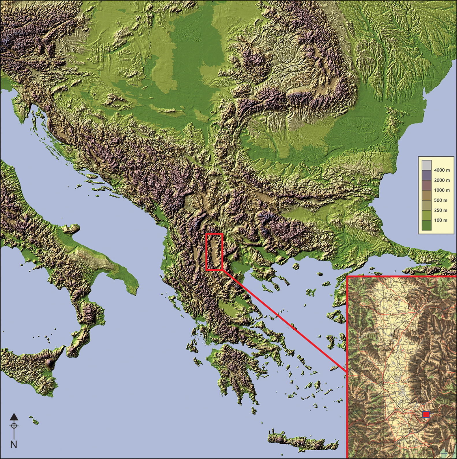
Pelagonia is one of the Balkan regions in which the first farming societies settled (Simoska & Sanev Reference Simoska and Sanev1976). It is formed of an elongated valley measuring approximately 80km, which spans the geographical region of Macedonia (Figure 1). Surrounded by high mountains, this valley functioned as an enclosed cultural area during the Neolithic, containing distinct material culture and architecture (Garašanin Reference Garašanin and Benac1979; Sanev Reference Sanev, Koco and Grozdanov1994).
Map of the Balkans, indicating the location of Pelagonia and the site of Vlaho (inset) (map from www.treehousemap.com, amended by G. Namov).
In the Early Neolithic, Pelagonia was settled by agricultural communities that constructed a number of tells along the valley floor. Due to the frequent advance of wetlands and the accumulation of resources (e.g. fertile soil, reeds, fish and birds), many tells were enclosed by one or more ditches (Naumov Reference Naumov2016). Alongside such tells, flat or tell settlements were established on the surrounding mountainous slopes, demonstrating settlement within a range of environments (Simoska Reference Simoska, Koco and Grozdanov1996). The buildings these farmers constructed and the artefacts they produced are, however, comparable to those from the valley floor, suggesting a shared identity that is manifest within the material culture.
Vlaho
One of the settlements established on the mountain slopes is the site of Vlaho, located south of Živojno village in south-eastern Central Pelagonia (Figure 1, inset). Positioned on a rocky sandstone terrace surrounded by two small rivers, this tell settlement faces destruction as a result of coal extraction initiatives in its vicinity (Figure 2). Due to the lack of a national preservation strategy and the need to study this Early Neolithic settlement, reconnaissance of the area began in 2020, followed by systematic prospection, excavation, geoarchaeological coring and magnetic scanning between 2021 and 2022. This fieldwork is complemented by post-excavation study of the finds, radiocarbon dating, and archaeozoological and archaeobotanical analyses (Naumov et al. Reference Naumov2021).
View of Vlaho from the east (after Naumov et al. Reference Naumov2021: fig. 2).

Initial survey indicated that Vlaho was a particularly large settlement for the Early Neolithic Balkans, with pottery scattered across approximately 6ha. This assessment was supported by a magnetic survey of 4.5ha of the terrace that revealed the presence of 13 semi-circular ditches—an unusually high number for Balkan and European prehistoric sites (Figure 3). While enclosures are a typical phenomenon for the Neolithic, and many settlements have similar circular ditches, these generally number between one and seven (Harding et al. Reference Harding, Sievers and Venclova2006). In the case of Vlaho, there are up to 13 ditches in the southern part of the settlement, with some smaller ditches joined with or penetrated by larger ones. Furthermore, a large, quadrangular, double-ditched enclosure is present within the same area; however, it cannot be determined at present whether this was constructed before or after the excavation of the semi-circular ditches. To the north of this enclosure there is a further large, circular ditch. This makes Vlaho unique, displaying a complex system of ditches that enclose either a settlement or another form of symbolic or economic setting.
Results of magnetic scanning, with anomalies related to ditches highlighted (figure by M. Przybyła and G. Naumov).

Stratigraphy and chronology
In 2021 and 2022, five 1 × 1m test trenches and one 10 × 5m context trench were excavated in order to understand the stratigraphy of the site. Trench 1 was positioned at the southernmost periphery of the settlement and uncovered 1.36m of cultural layers, while in Trench 3, positioned at the easternmost edge, these layers extended to a depth of 0.63m. Taking into account geoarchaeological coring conducted in 2022, which demonstrates an even greater depth of cultural deposits (2.40m) approximately 100m north-west from Trench 1, these trenches reveal archaeological layers that indicate the outline of the tell. The excavated layers in Trench 1 comprise 14 cultural layers above sandstone bedrock and contain seven architectural features that could belong to a number of individual buildings or represent the renewal of several structures (Figure 4).
Harris Matrix showing the stratigraphy of the layers in Trench 1 (figure by G. Naumov).
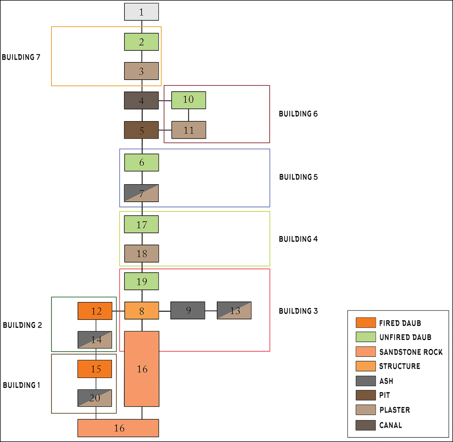
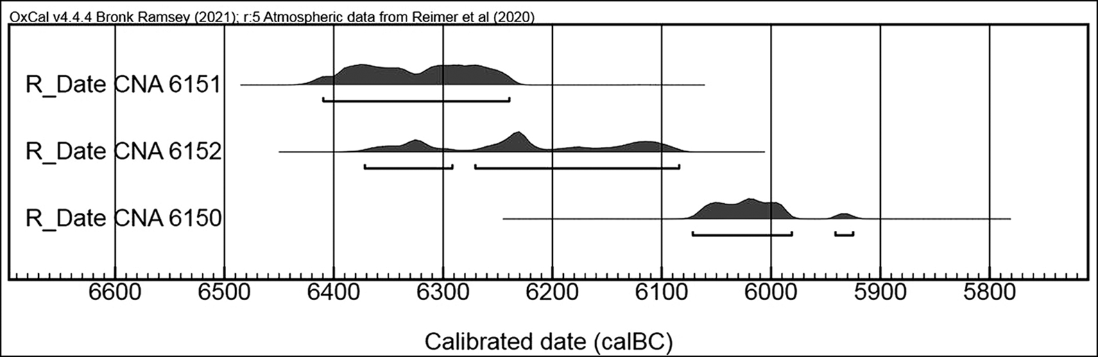
All the archaeological layers contain solely Early Neolithic material. An Early Neolithic date for the site is supported by radiocarbon dates obtained from charred cereal grains. The earliest date, which is related to Building 3 in Trench 1, provides a range of 6410–6240 cal BC at 95% probability (CNA 6151: 7460±36 BP; all dates produced using OxCal v4.4.4 (Bronk Ramsey Reference Bronk Ramsey2021) and calibrated using atmospheric data from Reimer et al. (Reference Reimer2020)) (Figure 5). This date is, so far, the earliest for the Neolithic in North Macedonia and one of the earliest in the Balkans as a whole, indicative of an early stage of the Neolithic Transition both in Pelagonia and the wider Balkan region (Naumov Reference Naumov2016; Reingruber & Thissen Reference Reingruber and Thissen2016). The latest date from Vlaho comes from Building 7, located within the topmost architectural layer in Trench 1, providing a date range of 6072–5982 cal BC at 90% probability (CNA 6150: 7151±36 BP), corresponding to the period when tells began to be established across the valley floor (Figure 5).
Chronological sequence of radiocarbon dates from Vlaho, produced using OxCal v4.4.4 (Bronk Ramsey Reference Bronk Ramsey2021) and calibrated using atmospheric data from Reimer et al. (Reference Reimer2020) (figure by G. Naumov).
Society and economy
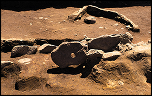
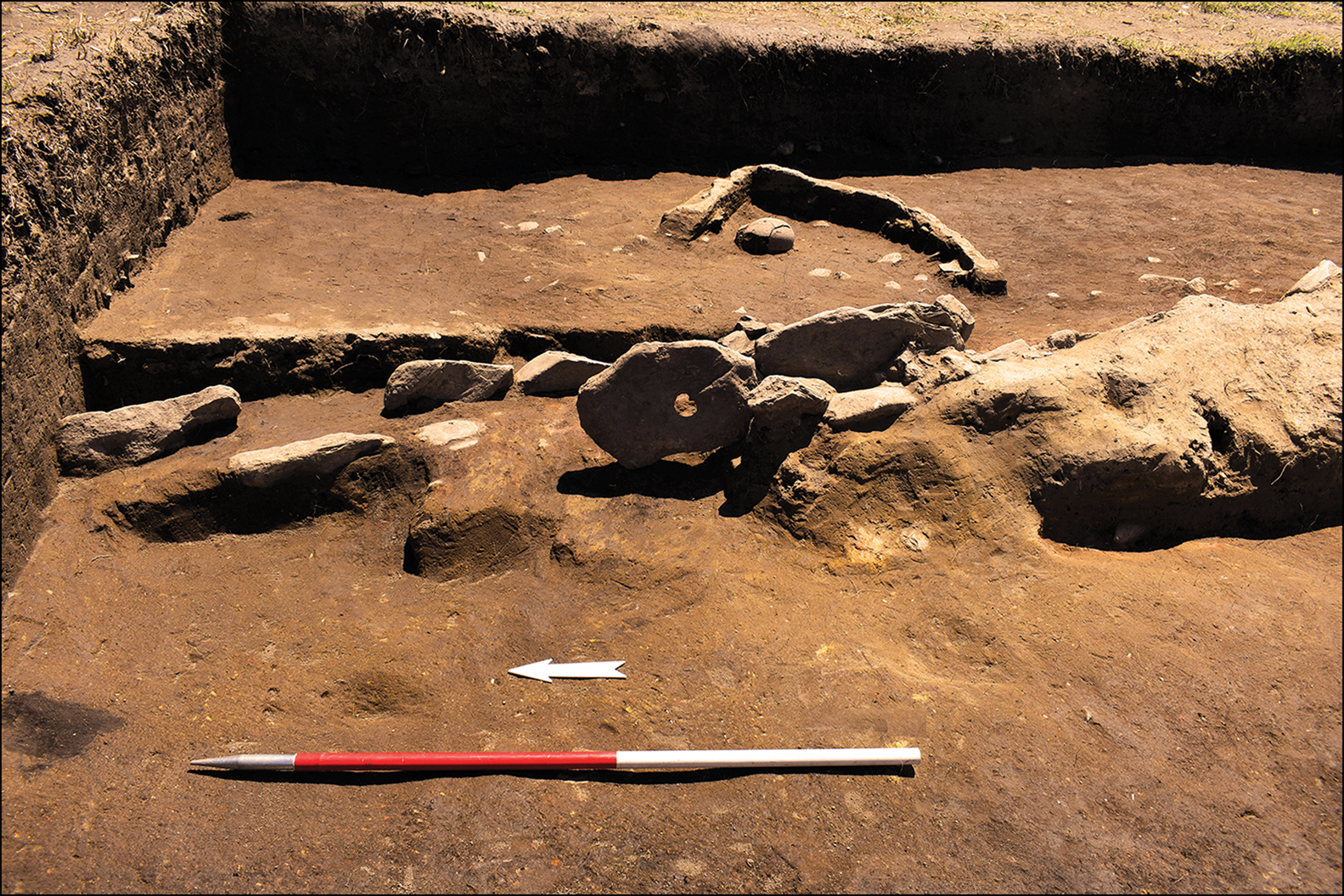
Although small in scale, the excavation of Vlaho has provided information about the community inhabiting this Early Neolithic settlement (Naumov et al. Reference Naumov2021). Their buildings were constructed of unfired daub, with posts used to outline and reinforce them, while hearths were dug into the sandstone bedrock. Another large structure, located in Trench 5, comprised walls formed by large, laterally inserted grindstones (Figure 6). A complete fine clay vessel was positioned upside down within this structure, alongside a large cattle horn. Pottery mainly consists of plates and jugs in a fine fabric, while jars and pots were made using coarse clay. Some plates are painted with white patterns (e.g. zigzags, triangles and ‘c’ motifs) or have impressed decoration (regularly referred to as impresso). There are also six clay figurines, four anthropomorphic models and nine house-like altars, which demonstrate symbolic engagement. A large quantity of stone axes (n = 17) and a modest assemblage of lithic and bone tools (n = 8) were also uncovered.
Structure with laterally set large grindstones in Trench 5 (photograph by G. Naumov).
The frequency of faunal remains was surprisingly large compared with other sites from Pelagonia. These belong predominantly to ovicaprids, cattle and pigs, and were highly fragmented. Boar and deer bones were also detected, suggesting diverse sources of meat. Archaeobotanical analysis demonstrates an abundance of wheat, barley, peas and lentils, in addition to dogwood, blackberries and white goosefoot.
Conclusion
The multidisciplinary research at Vlaho continues to improve our understanding of the Neolithic Transition in Pelagonia. Its establishment and continuation between 6400 and 6000 BC require a reconsideration of the demographic routes employed by the first agricultural communities in the Balkans, and a particular focus on the societies settled within this valley. Regarding its spatial organisation, with dozens of semi-circular and quadrangular ditches, Vlaho is considered to be unique within the Balkan Neolithic. The site's potential destruction due to coal mining in the immediate vicinity will, however, obstruct further research. As a result, the preservation of Vlaho is essential in order to secure future study of the site and to understand the uncommon quantity of ditches and their function within the settlements of the first agricultural societies in Pelagonia.
Acknowledgements
The authors are grateful to the Institute and Museum of Bitola and students from Ss. Cyril and Methodius University, Goce Delčev University, the University of Belgrade and the University of Tirana for their contribution to the research of Vlaho.
Funding statement
The research has been made possible by the kind support of the Foundation for the Study and Preservation of Tells, Western Balkans Fund, the Macedonian Ministry of Culture, the Ministry of Science and Innovation and State Research Agency of Spain and the University of Basel.


 Open access