


Introduction
The Neolithic period in south-eastern Arabia (c. 6500–3300 BC) diverges from traditional markers of Neolithisation such as sedentism, plant cultivation and the production of ceramics (Crassard & Drechsler Reference Crassard and Drechsler2013; McCorriston Reference McCorriston2013). Instead, this period saw unique local adaptations, including innovations in lithic technology, cultural transmission, migration, pastoralism and specialised coastal fishing strategies. These adaptations coincided with shifting climatic conditions from the Holocene Humid Period to increasing aridity in the fourth millennium BC (e.g. Lezine et al. Reference Lézine, Ivory, Braconnot and Marti2017; Maiorano et al. Reference Maiorano, Crassard, Charpentier and Bortolini2020). While coastal surveys and excavations have provided a foundational understanding of the chronology and material culture of the south-eastern Arabian Neolithic (e.g. Charpentier et al. Reference Charpentier, Maiorano, Marchand, Vosges and Borgi2023), the inland regions remain underexplored. Only a handful of inland sites have been identified (Figure 1), including Hayy al-Sarh in Oman (Bretzke & Parton Reference Bretzke and Parton2020) and Jebel al-Buhais, Jebel Faya and Wadi Hilo in the United Arab Emirates (Uerpmann et al. Reference Uerpmann, Uerpmann, Kutterer and Jasim2013, Reference Uerpmann2018). The discovery of a large, repeatedly occupied Neolithic site at Al-Khashbah (KHS-A), securely dated through radiocarbon analysis, presents a crucial opportunity to study inland Neolithic lifeways and their adaptations to climate change. Our project investigates how mobile hunter-herder communities adapted to Holocene climate deterioration through mobility, seasonality and/or flexibility between hunting and herding. By conducting a multidisciplinary analysis of KHS-A, we aim to reshape narratives of Neolithic desert-dwelling populations and archaeological conceptions of resilience in Arabia.
Overview of the KHS-A site looking north, with an inset map of northern Oman showing the location of KHS-A and inland Neolithic sites in the study region (in red) (figure by M.P. Maiorano & L. Proctor).

Investigating Neolithic Al-Khashbah
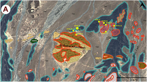
KHS-A is 4km north-east of Al-Khashbah village, in the southern piedmont of the Hajar Mountains (Figure 1) close to a large Early Bronze Age complex (Schmidt et al. Reference Schmidt2021). In the Neolithic, this area may have been an attractive location due to chert-bearing geological formations and its position at a crossroads of east–west piedmont routes and the north–south Samad al-Shan pass. In February 2022, we surveyed several Pleistocene alluvial terraces north-east of Al-Khashbah, mapping geomorphology and identifying three possible Neolithic sites (Figure 2A: KHS-A, B & G) and five chert outcrops (KHS-C–G). These sites featured stone alignments, hearths and lithic scatters (Figure 2B). Based on size (approximately 3600m2) and feature density, KHS-A was selected for further study.
A) Map of identified archaeological sites, the main chert-bearing lithological units and ancient fluvial terraces. B) Portion of KHS-A showing trenches and visible stone features (figure by T. Beuzen-Waller & M.P. Maiorano).

After documenting visible features and collecting artefacts, we placed a 2 × 2m test trench around structure KHS-A.1 to assess preservation potential (Figure 3A). Excavations revealed at least two occupational phases, the second fireplace (B) was well-preserved with abundant charcoal fragments, and a sterile gravel layer was reached at a depth of about 0.3m.
KHS-A.1 and section of the deepest sounding (A.1–2). Plan of KHS-A.13 showing the distribution of features and the largest ground stone tools (B). South (C.1) and west (C.2) sections of test-pit A (TP-A) (figure by L. Proctor & M.P. Maiorano).

In 2023, we excavated KHS-A.13 to expand our understanding of the Neolithic site. This trench consisted of a 3 × 4m exposure (Figures 1 & 3B) and a test pit (TP-A) in the north-east corner to assess the depth of the archaeological deposit (Figure 3C). Ashy deposits alternated with sandy layers and small gravels, revealing multiple well-preserved fireplaces, ash pits, post-holes, large grinding stones and a possible tethering stone.
Radiocarbon results (Figure 4) suggest KHS-A was occupied at least twice over 1000 years. The oldest date (5753–5657 cal BC) came from TP-A (Figures 3C.1 & 4), while the most recent date (4040–3805 cal BC) came from Fireplace C in KHS-A.1. Remaining fireplaces consistently date to the sixth millennium BC suggesting that they were used simultaneously or repeatedly over a relatively short period.
Calibrated radiocarbon dating results from KHS-A.1 and KHS-A.13 (figure by L. Proctor).

A diverse range of materials was recovered from the excavations. Twenty-five beads, made by perforating the shells of marine gastropods, were found throughout the excavations along with several unworked shells and preforms (Figure 5A). The lithic material consists of a largely homogeneous, opportunistic assemblage of 2519 elements, mostly chert (98%, of which three-quarters are from the red radiolarite chert in the local Ar1 formation, Figure 2A), along with limestone (from Si 1-2, Figure 2A), quartz and basalt. The most common retouched pieces include perforators and notches, followed by scraping tools, denticulates and retouched flakes (Figure 5B). Unlike at most sixth–fifth millennia BC sites in Oman, bifaces are rare. Cores and debitage elements are currently being analysed (Figure 5C) to reconstruct production techniques. Hammers and grinding stones (Figure 5D) are also present, suggesting activities related to the processing of organic materials.
Shell beads (A), retouched flakes (B), cores (C) and ground stone tools (D) found at KHS-A.13 (figure by M.P. Maiorano).

Archaeobotanical remains include more than 500 identifiable charcoal fragments (Figure 6a–c). Seventy-five per cent of the charcoal from KHSA-13 is acacia (Vachellia sp.) from fireplaces 5, 6, 7, 9 and 11. Meanwhile, a more diverse range of taxa, including Prosopis cineraria, Ziziphus, acacia and, notably, white mangrove (Avicennia marina; Figure 6a) are identified in KHS-A.1. White mangrove grows only in coastal wetlands, and therefore provides evidence for connections between the Al-Khashbah and the Omani coast.
Transverse sections of identified wood charcoal (a–c) and tooth fragments (d) from KHSA-13 (figure by L. Proctor & E. Maini).

Faunal remains consist of 278 fragments of long bones and teeth of which we identified 36 post-cranial bone elements. Teeth, maxillary and mandibular elements (n = 34) could only be attributed to small to medium-sized herbivores. High fragmentation prevents conclusive distinction between domestic (caprines) and wild (oryxes or tahrs) herbivores (Figure 6d).
Discussion and future development
In summary, the site of KHS-A promises to enhance our understanding of the Arabian Neolithic in inland Oman. Initial results suggest that the site was periodically occupied during the sixth and fifth millennia BC and was likely a short-term camp where people were engaged in stone tool/bead production and animal processing. Lithic remains from the site show unique characteristics that differ from contemporaneous sites on the coast, while seashell ornaments and mangrove wood hint at direct connections with the coast. Questions remain about Neolithic subsistence strategies, mobility and the environmental conditions in which they lived. However, the preserved stratified features containing artefacts and plant and animal remains present an unprecedented opportunity to ask these questions in central Oman.
Acknowledgements
We thank the Ministry of Heritage and Tourism of the Sultanate of Oman for supporting this research. Further thanks go to Conrad Schmidt for assisting with imagery and GIS recording. We also wish to express our gratitude to Marlisa Mazzola and Beatrice Demarchi of the ArchaeOBiomics Laboratories at the University of Turin, Italy, for conducting the ZooMS analyses.
Funding statement
The project was funded by the German Research Foundation (DFG), the Humboldt Foundation, the German Ministry for Education and Research (BMBF), and the Institute of Archaeology of the Czech Academy of Sciences (ARUP).


