


Introduction
The number of protected areas has increased rapidly since the late 19th century, and particularly since the 1980s. From c. 4 million km2 in 1982 (Harrison et al., Reference Harrison, Miller and McNeely1982), protected areas now cover c. 19.8 million km2 (14.7%) of terrestrial and inland water area, as well as 10.2% of coastal and marine areas under national jurisdiction and 4.1% of the global ocean (UNEP-WCMC & IUCN, 2016). The Aichi targets set out under the Convention on Biological Diversity require countries to protect 17% of their land and 10% of their marine areas by 2020 (Juffe-Bignoli et al., Reference Juffe-Bignoli, Burgess, Bingham, Belle, de Lima and Deguignet2014; UNEP-WCMC & IUCN, 2016). The Democratic Republic of Congo (DRC) has committed to set aside 17% of its area for conservation to meet its Aichi target by 2020.
Establishment of protected areas in Africa has had a long and controversial history, from the establishment of the Sabi Game Reserve in 1898 (which became Kruger National Park) and Virunga National Park, the continent's first National Park, in 1925. Many protected areas were created in response to an observed decline in numbers of large mammals as a result of hunting, the increasing human population, and associated land conversion. Their aim was to keep people out and preserve the ‘pristine wilderness’ of Africa, an approach that has been called fortress conservation (Hulme & Murphree, Reference Hulme and Murphree1999, Reference Hulme and Murphree2001). Rightful criticism has been made of this exclusionary process, which led to many human rights abuses and forced evictions in the first half of the 20th century. However, even some of the early protected areas considered the needs of local communities; for example, Queen Elizabeth National Park in Uganda shared 50% of revenues with local communities when it was first established (Willock, Reference Willock1965). The focus on winners and losers in protected area establishment has been challenged more recently, with studies showing that communities can gain benefits from protected areas at certain times and not at others, depending on the social and political context (Kelly & Gupta, Reference Kelly and Gupta2016). Others have decried the lack of robust data on the impacts of protected area creation (West et al., Reference West, Igoe and Brockington2006). Community conservation through integrated conservation and development projects has been struggling to have an impact, and it has become clear that engaging individual communities in protected area management is critical (Horwich & Lyon, Reference Horwich and Lyon2007). There is increasing recognition of the need for conservation to focus on landscapes for people and nature (Palomo et al., Reference Palomo, Montes, Martín-López, González, García-Llorente, Alcorlo and Mora2014; Cumming et al., Reference Cumming, Allen, Ban, Biggs, Biggs and Cumming2015), taking a more holistic approach to people and the management of nature.
It is widely acknowledged now that protected areas need to be established in consultation with local communities, ensuring that human rights and socio-economic needs are respected throughout the process. Here we describe the establishment of the Itombwe Natural Reserve, in eastern DRC, which has had a chequered history, having initially been imposed upon the people living in the Itombwe Massif (a classic case of fortress conservation). Subsequent engagement of local people led to a better outcome both for the people and for biodiversity conservation, through the creation of a protected area that was supported by the people living within and around it.
Study area and biodiversity surveys
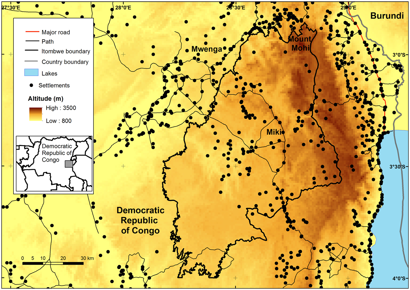
The Itombwe Massif is located on the western escarpment of the Albertine Rift at the northern end of Lake Tanganyika (Fig. 1). It is thought to have been a Pleistocene refugium during the last glaciations, which led to speciation and may explain the high numbers of endemic species confined to the Massif (Laurent, Reference Laurent1964; Prigogine, Reference Prigogine1971, Reference Prigogine1978, Reference Prigogine1984, Reference Prigogine and Ouellet1986; Greenbaum & Kusamba, Reference Greenbaum and Kusamba2012). Doumenge (Reference Doumenge1998) noted that ‘the Itombwe Mountains have the second largest, if not the largest, actual area of submontane, montane, and subalpine forests in continental Africa.’
The original boundary of the Itombwe Natural Reserve as designated in the 2006 gazettement document by the Minister of Environment of DRC.
The Itombwe Reserve has been identified as a site of significant importance for the conservation of threatened and endemic birds (Wilson & Catsis, Reference Wilson and Catsis1990; Doumenge, Reference Doumenge1998; Omari et al., Reference Omari, Hart, Butynski, Birhashirwa, Upoki and M'Keyo1999) and amphibians (Laurent, Reference Laurent1964; Evans et al., Reference Evans, Carter, Tobias, Kelley, Hanner and Tinsley2008; Greenbaum & Kusamba, Reference Greenbaum and Kusamba2012). In an assessment of the Albertine Rift region, Plumptre et al. (Reference Plumptre, Davenport, Behangana, Kityo, Eilu and Ssegawa2007) found it contained more endemic and threatened species than any other region in Africa, and that Itombwe was one of the richest sites for biodiversity in the Albertine Rift (Table 1). The site is an Endemic Bird Area, an Important Bird Area, an Alliance for Zero Extinction site and a Key Biodiversity Area under the Eastern Afromontane Hotspot. Surveys of the large mammal fauna conducted by the Wildlife Conservation Society (WCS) in 1996 recorded the presence of several large mammals of conservation concern, notably the Critically Endangered Grauer's gorilla Gorilla beringei graueri, and increased the number of bird species known from the Massif to 588 (Omari et al., Reference Omari, Hart, Butynski, Birhashirwa, Upoki and M'Keyo1999). The region has suffered the impacts of regional armed conflict among refugees who fled the Rwandan genocide in 1994, and subsequent surveys made by WCS during 2003–2006 found increasing threats and the presence of several armed groups controlling various parts of the Massif.
Known numbers of terrestrial vertebrates and plant species occurring in the Itombwe Massif in DRC (Fig, 1), with numbers of species endemic to the Albertine Rift and numbers of species that are globally threatened (WCS, unpubl. data).

*CR, Critically Endangered; EN, Endangered; VU, Vulnerable; DD, Data Deficient
Given the high biodiversity of the region the Minister for the Environment in Kinshasa declared unilaterally that a reserve would be established in Itombwe Massif, and a gazettement document was written in October 2006. No boundaries were delimited in this document, although it included a map from a WCS report (Fig. 1), and this created confusion and anger amongst the communities of the Itombwe Massif, who had not been consulted about the reserve.
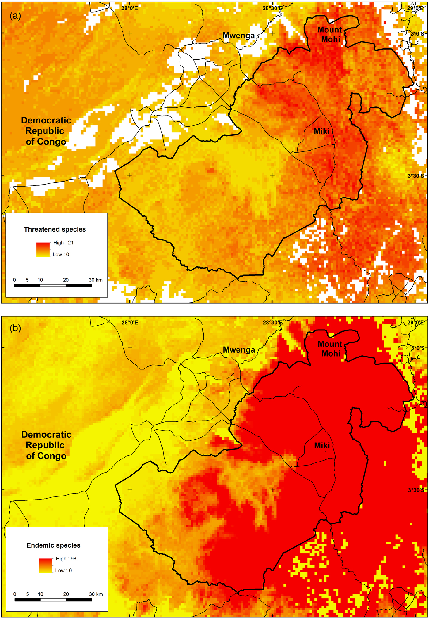
Data from surveys made by WCS, as well as from historical surveys, were used to develop species distribution models for species that are categorized as threatened on the IUCN Red List (IUCN, 2016) and endemic to the Albertine Rift region (Plumptre et al., Reference Plumptre, Davenport, Behangana, Kityo, Eilu and Ssegawa2007). The methods used to develop these models are described in detail by Plumptre et al. (Reference Plumptre, Kujirakwinja, Ayebare, Mitamba, Muhindo and Twendilonge2013) and Ayebare et al. (unpubl. data). The distribution maps were combined to identify hotspot areas for species of conservation concern in the Itombwe Massif (Fig. 2). These identified that habitat on the escarpment above Lake Tanganyika was particularly important for conservation and that the initial boundaries in the 2006 gazettement did not capture the most important areas for some of the endemic and threatened species (Plumptre et al., Reference Plumptre, Kujirakwinja, Ayebare, Mitamba, Muhindo and Twendilonge2013). This finding was used to redefine the boundaries following a consultative process with local communities (see next section).
Predicted richness of (a) threatened and (b) endemic species of the Albertine Rift in the Itombwe Massif, with the revised boundary of the Itombwe Natural Reserve derived from consultations with local communities.
Political challenges and approaches
The declaration of the Itombwe Reserve in 2006 led to consternation among the people living in Itombwe. They had not been informed about any plans to protect the area, nor had the protected areas authority in DRC, Institut Congolais pour la Conservation de la Nature, or its conservation partners (WWF and WCS) who had been working in the area. A local NGO, Africapacity, supported by Rainforest Foundation UK and Rainforest Foundation Norway, wanted to take the issue to court and degazette the Reserve, whereas conservation partners were unsure how to proceed but did not want a total degazettement, as it would then be more difficult to establish any sort of protected area. In 2007 the United States Agency for International Development (USAID) was supporting conflict resolution projects in eastern DRC, and WCS obtained a grant to tackle conflicts over access to natural resources in the Albertine Rift region. The International Institute for Sustainable Development together with the Conservation Development Centre developed a process that provided a conflict-sensitive approach to conservation (Hammill et al., Reference Hammill, Crawford, Craig, Malpas and Matthew2009). During 2008–2009, using the funding from USAID, WCS tested this approach in several sites in eastern DRC, including the Itombwe Massif, following the unexpected gazettement.
In 2008 WCS initiated a dialogue process in which the international NGOs WWF, Rainforest Foundation UK, Rainforest Foundation Norway and WCS, together with Africapacity and Institut Congolais pour la Conservation de la Nature met to discuss issues related to the creation of the Reserve. Specifically, these meetings provided a forum in which all sides could express their concerns and hear the real (as opposed to perceived) views of the other stakeholders. Rainforest Foundation UK, Rainforest Foundation Norway, and Africapacity wanted to make sure that the rights of the people living inside the Reserve were respected, and to annul the arrêté (gazettement document) that created the Reserve. WWF and WCS were opposed to the way in which the Reserve had been created, without consultation, but were also concerned that annulling the arrêté would potentially mean that the opportunity to create a protected area in the Itombwe Massif would be lost. None of the NGOs were happy with the way in which the Reserve had been gazetted, and all of them considered it to be an infringement of the rights of the people living in the Massif. A meeting was held in London in March 2009 between Rainforest Foundation UK and WCS at which positions were shared and it was agreed that a meeting near Itombwe should take place to discuss the issue and agree on a way forward. Agreed terms of reference were established between the five NGOs (Africapacity, Rainforest Foundation UK and Rainforest Foundation Norway, WCS and WWF) to articulate the aims of the planning meeting and the joint mission to the field that would take place in July 2009, and present the idea of using participatory mapping to identify zones for the Reserve. In July 2009 a meeting was held between the NGOs and Institut Congolais pour la Conservation de la Nature in Bukavu to obtain agreement on the desired outcomes. Once the NGOs and Institut Congolais pour la Conservation de la Nature were in agreement a larger meeting was organized in July 2009, to bring together the major stakeholders from Itombwe community to discuss the problem, to share the various positions about the arrêté, and to decide on a way forward that could be acceptable to everyone. A larger meeting was held in late 2009 to bring together a wider group of stakeholders and plan together for the Itombwe process. This meeting brought together traditional leaders from the Massif, the NGOs, and Institut Congolais pour la Conservation de la Nature to plan a way of demarcating the boundaries of the Reserve in a participative manner. The process used during these meetings was based on the conflict-sensitive conservation approach developed by the International Institute for Sustainable Development and WCS, and tested by WCS in the eastern DRC, including Itombwe (Hammill et al., Reference Hammill, Crawford, Craig, Malpas and Matthew2009; Kujirakwinja et al., Reference Kujirakwinja, Shamavu, Hammill, Crawford, Bamba and Plumptre2010). At each stakeholders’ meeting the social and ecological importance of the Reserve and the history of its creation were outlined. Discussion topics were oriented towards the current status of the forest, and benefits that communities may have gained from the destruction of the forest. Transparent and open discussions were encouraged, and the recognition of cultural values and beliefs was a key element in helping build consensus. These open discussions facilitated a better understanding of the positions and interests of various parties, and identification of areas of consensus that could be built upon. In some instances meetings were held informally with conflicting groups prior to the wider meetings if it was felt that these conflicts could de-rail the larger meeting if left unresolved.
As a result of the meetings, all parties agreed to support the establishment of Itombwe Natural Reserve, review the arrêté with more local participation, and ensure that local communities were consulted at each stage so that their concerns were taken into account. An action plan was developed and the roles of the various stakeholders agreed. Specific actions included:
• An agreed joint mission to the field to meet with local community leaders to obtain their inputs into the idea of zoning the Reserve using a participative approach.
• Gathering existing biological and socio-economic data and assessing gaps in the data.
• Developing a joint work plan to ensure local participation and protection of biodiversity.
• Producing a baseline map of the Reserve, from which discussions could be undertaken with the local communities.
• Obtaining feedback and views from local communities about the work plan and activities to be implemented.
• Eliciting the support of the provincial government, to ensure field activities were supported at a political level.
• Working with communities to agree on the boundaries of the Reserve and discuss the plans for zoning the Reserve.
The four NGOs also agreed to share data that had been gathered in the Reserve, and use it in establishing a baseline for zoning (a process of land allocation to various uses with different management objectives; Lockwood et al., Reference Lockwood, Worboys and Kothari2006). The zones were to be defined based on biodiversity data and the locations of existing settlements with associated development zones. At the time, agreed zones were to represent three types of land use: (1) a conservation zone with no human use; (2) a multiple-use zone with limited human use and sustainable harvesting of resources, and (3) a development zone, in which sustainable development projects would be encouraged and supported in villages. More detailed zoning would take place within these types following discussions at village level.
An estimated 675,800 people live in or around the Itombwe Reserve. A process of participatory mapping of the boundaries of the Reserve was started in 2010, with Africapacity, Institut Congolais pour la Conservation de la Nature, WCS and WWF staff participating in consultations with each of 550 villages within and around the proposed boundary of the Reserve, and meeting with c. 200,000 people during these consultations (an estimated 29.5% of the population). Given the size of the area and the number of villages (some visited more than once) this process took several years, and was completed in 2014. However, this resulted in a better outcome for conservation because it gave time for further analysis of the biodiversity data and led to the inclusion of more of the higher altitude habitat where many of the endemic and threatened species occur (Fig. 2) as well as a region that is predicted to be important for Itombwe's species under future climate change scenarios (Plumptre et al., Reference Plumptre, Kujirakwinja, Ayebare, Mitamba, Muhindo and Twendilonge2013). In June 2014, after the boundaries were agreed and mapped, a political process was instigated at provincial level to formalize the boundaries legally. In DRC a protected area must be established by a Province before it can become legally established nationally (a law that was put in place after the initial gazettement of Itombwe in 2006). A provincial committee (Conseil Consultatif Provincial des Forêts) had to be established for the Province of South Kivu to review the documentation and ensure the consultations were adequate before the Governor of South Kivu signed the official designation of the boundaries of Itombwe Natural Reserve on 23 June 2016.
Zoning planning
It was agreed with communities that once the boundary was agreed and the Reserve officially established that a zoning process would be implemented, taking into account the needs of people and wildlife. The Wildlife Conservation Society had developed ideas for the zoning process, which were shared with partners and leaders of the community (Plumptre et al., Reference Plumptre, Kujirakwinja, Ayebare, Mitamba, Muhindo and Twendilonge2013) in several presentations and meetings in 2013 and 2014. A local NGO, Réseau des associations pour la conservation communautaire du Massif d'Itombwe (RACCOMI), was engaged to work on a pilot project in 2015 for zoning of the West Mwana Valley, and they in turn collaborated with several other local NGOs (Groupe d'Expertise et de Capacitation des Entreprises et Organisation Non Gouvernementale, Recherche Action pour la Conservation et le Développement, Itombwe Génération Humanitaire, and Action de la Jeunesse d'Itombwe pour le Développement). This approach demonstrated the methods and started the process of zoning the Reserve. This valley was one of the regions where Grauer's gorilla and elephant Loxodonta cyclotis signs were known, and was considered to be an important area for the conservation of these two species.
Mapping methods were based on International Fund for Agricultural Development best practices (IFAD, 2009) and included:
1. A technical meeting, including facilitators and financial supporters, to develop appropriate methods in the context of Itombwe.
2. Planning meetings with traditional chiefs to ensure they were aware and approved of activities related to participatory mapping. This is mandated in DRC, as traditional chiefs have power over people and land.
3. Community meetings to explain the importance of mapping the forest, and to elicit local people's views regarding the use of the forest. During these meetings, cultural sites and key sectors for livelihoods (e.g. bushmeat hunting, mining, timber) were identified. Communities chose among themselves people who would be involved in data collection for mapping, and these people were trained in the use of a global positioning system (GPS) for data collection. During these preliminary meetings, communities sketched maps of their land.
4. GPS data collection was conducted based on proposed zones and cultural sites. A map was then produced using a geographical information system, to represent zones within the forest (Fig. 3).
5. Meetings were held to review the map, make changes where necessary and agree on zones and a local governance committee.
The proposed core zone for the Itombwe Natural Reserve, which was discussed at the time of the delimitation of the boundary of the Reserve, with the zoning of West Mwana Valley for various land uses identified by the local communities.
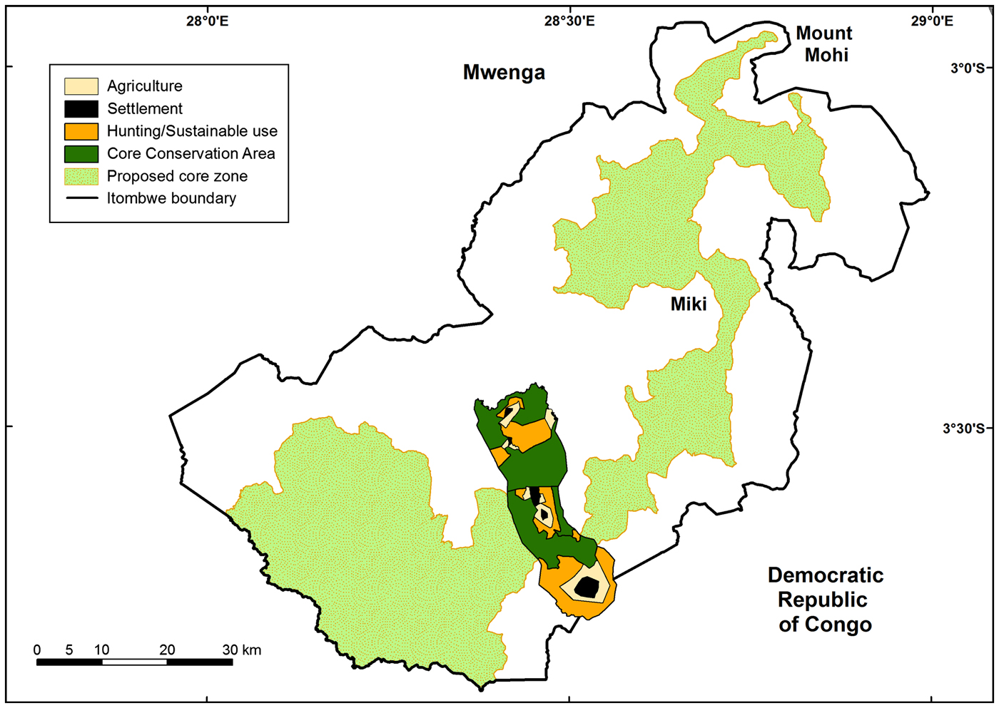
Together with members of the Mwana community, RACCOMI explained the zoning process to the communities in the valley and presented to them the results of the biological surveys and the mapping of the Reserve boundary. They then discussed the types of zones that the community would want to consider and identified the following options: core protected zones, sustainable use of non-timber forest products, sustainable use of timber, sustainable hunting areas, sites of cultural importance, expansion areas for agriculture, and expansion areas for villages. The Mwana Valley communities opted to increase the area of core habitat to protect the gorillas and elephants in their area as well as identifying areas for sustainable hunting and agriculture (Fig. 3). The total area zoned in the Mwana Valley for all of the various land uses was 106 km2, c. 1.8% of the Reserve.
Lessons learned from the establishment of Itombwe Reserve
The Itombwe Massif is one of the most biologically rich sites in Africa and, with several species confined to this region, it is important that it should be conserved and managed both for the species of conservation concern and for the people living in the region. Although Itombwe Reserve was initially created using a top-down approach, the process described here is an example of how the data from biological surveys and species distribution mapping, together with a conflict-sensitive conservation technique and participatory approaches, can bring people at a site together to produce a result that benefits both people and conservation (Fig. 4). By engaging communities in the process, not only was the protected area expanded but local ownership and participation in managing the Reserve were also ensured. Zoning is still ongoing but in Mwana Valley it was led entirely by community members, with training and guidance from WCS. A local committee was established, and meets regularly to evaluate progress and address issues that arise. It is too early to assess the impact on wildlife but communities now allow rangers to visit the core protection areas.
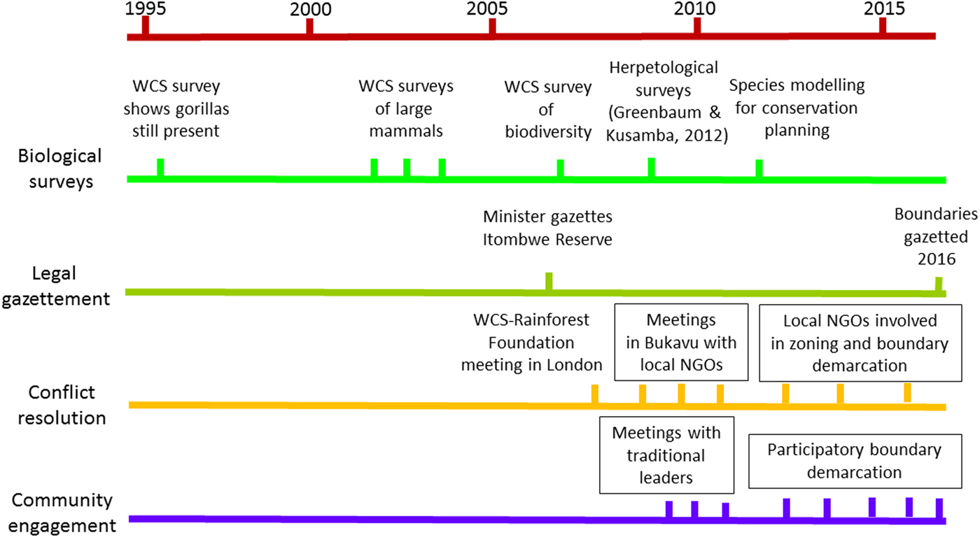
A timeline of the key activities that led to the creation of the Itombwe Reserve. Boxed text indicates that activities took place over several visits.
The conflict resolution approach used in this process was useful in analysing the conflict, the underlying causes and the main actors involved. Using an approach that brought all stakeholders together and gave them an equal say in the process, it was possible to move beyond the initial confrontation to identify solutions that would be acceptable to everyone. Having the biological data available showing the global importance of the site for conservation helped focus people on how best to conserve the area without excluding the rights of the people living there, and explore ways they could benefit from the establishment of the Reserve.
One of the key reasons why communities were willing to set aside land for conservation in eastern DRC is that the insecurity since the influx of Rwandan refugees, the war in the country and the establishment of many armed groups has led to large movements of people seeking secure areas. Various ethnic groups have moved to new areas and attempted to settle where there is space; however, they do not always integrate within the existing communities and this leads to conflict. People are recognizing that establishment of protected areas is one way to retain some control over their ancestral lands and to limit immigration, particularly among the more marginalized peoples in the country, a view expressed during some of the meetings.
A second reason is that communities hope to attract some international attention to their area by establishing a protected area, and that the region will benefit financially as a result. The development of tourism in Itombwe is likely to take time; however, the establishment of the Reserve is bringing attention to a region that historically has been ignored by aid agencies and the government because of its remoteness. There are clearly expectations that people will benefit from development support and it is important that conservation agencies try to link with development groups to bring in funds to support this. Ongoing funding will be needed to fully establish the site as a Natural Reserve, ensure its sustainability, and employ people locally. There is also a need for improved security in the area, as there are remnants of the forces that carried out the genocide in Rwanda, as well as other armed groups, present in the Massif. However, the fact that all the ethnic and political groups have come together and agreed to the establishment of the Reserve is an indicator of how the community could move forward and attract support for the region.
The lessons learned from this process that could be applicable elsewhere include the following:
1. It is important to have scientific evidence that shows the importance of the site, particularly its global importance. In the case of Itombwe, scientific data were used as the baseline to bring people back to a common goal when arguments became heated: given the importance of the site, how could we all work together to protect it?
2. It was important to bring everyone together in a forum that was neutral and where they could voice their concerns and feel they were being listened to. Initially there were many false perceptions among the various groups, but these were diffused when it became clear they were false. Having a good facilitator who understood the local politics and people was important in ensuring that meetings remained focused and worked towards a clear goal.
3. Ensuring that people were consulted regularly and were able to actively participate in designing the Reserve was important, as the process took c. 6 years to complete. This was achieved through regular meetings and visits to the villages.
4. A good understanding of the social and cultural values in the communities was a key to success in the participatory boundary mapping and the start of the zoning process because it helped negotiate the underlying politics between ethnic groups.
5. Conflict resolution skills were important to facilitate completion of the participatory mapping and to start the zoning, and the experience of WCS staff in developing and using these skills was useful (Hammill et al., Reference Hammill, Crawford, Craig, Malpas and Matthew2009).
If Itombwe Reserve is to be conserved in the long term it is important that the zoning that was started in the Mwana Valley is completed within the next few years, and WWF is being funded by the USAID Central Africa Forest Ecosystems Conservation project to continue this work within the communities. It will also be necessary that communities realize tangible benefits from the Reserve beyond its ability to protect their ancestral land from immigrants. There is a need to engage development agencies and plan development projects that will support the communities so that they in turn will continue to support the Reserve. This will require sustained funding, which will have to come from international donors initially until security and the possibilities of tourism and other sustainable funding can be investigated.
Acknowledgements
We are grateful for the support for the establishment of Itombwe Natural Reserve provided by the Critical Ecosystem Partnership Fund (Grant 62610), Institut Congolais pour la Conservation de la Nature, the IUCN Save Our Species Programme (2011A-012), Prince Albert Monaco II Foundation, Rainforest Foundation UK, Rainforest Foundation Norway, Rainforest Trust, the United States Agency for International Development (64788), U.S. Fish and Wildlife Service (F12AP00192), WCS and WWF. We are also grateful for the comments received from two anonymous reviewers.
Author contributions
DK led much of the work to establish the Itombwe Reserve for WCS. AJP oversaw his work, raised funds and wrote the article. AT and GM (WCS) worked with the communities to agree on the Reserve boundaries, together with LM (WWF), JDDW (Rainforest Foundation UK and Rainforest Foundation Norway initially, then Africapacity) and OB (Institut Congolais pour la Conservation de la Nature). OK and BS (RACCOMI) led the pilot zoning in Mwana, SA created the species distribution models and RT led the project in DRC for WCS.
Biographical sketches
D. Kujirakwinja is interested in ways of engaging local people in conservation, and his research focuses on political ecology. A.J. Plumptre has been involved in using biodiversity surveys to identify key biodiversity areas in the Albertine Rift region. A. Twendilonge, G. Mitamba and S. Ayebare collected biodiversity data and modelled the species distributions for the Wildlife Conservation Society (WCS), and AT and GM engaged communities in mapping the limits of Itombwe Natural Reserve. L. Mubalama manages the WWF project in Itombwe and is interested in ways of engaging communities in conservation. J.D.D. Wasso, O. Kisumbu and B. Shamavu lead local NGOs from the Itombwe region and are interested in engaging their respective communities in conservation of Itombwe. O. Bitomwa is the Institut Congolais pour la Conservation de la Nature director of Itombwe Reserve and is interested in ways of managing such a reserve with the involvement of local people. R. Tshombe is the Democratic Republic of Congo country director for WCS and for over 25 years has had an interest in engaging communities in conservation.


