




In 1914, J.H. Stephens, who had served as an engineer in the Public Works Department in the Madras government and had spent time from the late 1890s to 1912 as a municipal engineer in Bangalore, authored a book titled Plague Proof Town Planning in Bangalore. In his own words, he had ‘had the opportunity of studying the plague in its native element’ and argued that any ‘permanent improvement’ to the city of Bangalore also had to be ‘plague proof’.Footnote 1 Focusing on the building of the suburb of Fraser Town as a response to the plague, Stephens argued that the town was ‘both plague proof and a health resort’.Footnote 2 Stephen's book came at the end of an era when disease dominated discussion on how to rethink urban space. Successively, cholera, dysentery, malaria and then the bubonic plague had hit the city of Bangalore and cities across the world.Footnote 3 Focusing on Bangalore city, this article shows how this era of disease has broader implications for studying urban space in South Asia and beyond. More specifically, it follows the flows of water and the built form, namely housing, to argue that the ‘sanitary city’ reveals how colonial ideas of health encountered complex urban environments, infrastructure and non-humans.Footnote 4
This article takes the British colonial and princely Mysore state's long engagement with disease and public health, the advent of new piped water systems as a response and the new moment of town planning arriving at the turn of the century to rethink three different kinds of literature on urban history and the geography of public health.Footnote 5 Urban historians of South Asia have often focused on the idea of colonial discourse and its implications for urban planning. Specifically, in an important article, Prashant Kidambi showed how the idea of disease as a problem of ‘locality’ emerged among colonial officials as a term to denote the unhygienic conditions that poor Indians inhabited and created.Footnote 6 Connected to this, urban geographers have argued that the late nineteenth and early twentieth centuries was the era when ‘health’ as a category was mobilized to produce difference.Footnote 7 Urban historians and geographers of South Africa, for instance, posit that the plague led to the planning and development of new kinds of racially segregated urban settlements.Footnote 8 In Cape Town, for instance, difference manifested through the creation of suburban white neighbourhoods and African townships.Footnote 9 Furthermore, other scholars have suggested that new water supply systems, as a response to disease-ridden cities, were ‘imperfect’ instances of European modernity.Footnote 10 These studies of water systems have been enveloped within the concerns of ‘moral and material progress’, or the idea of British liberalism infiltrating the colonies. This further created racial categories and divisions, namely that the British labelled natives as ‘insanitary’ and ‘dirty’, while the new water supply systems were to civilize the savages.Footnote 11
While scholarship has so far focused on ideology and identity in the city, I argue that foregrounding the urban environment, namely water bodies, biota and non-humans (such as cows and rats), sheds light on the entrenched genealogies of modernist projects in cities. More theoretically, I focus on concepts of flows of water and fixity of infrastructure through ideas of the metabolic city and the techno-sphere. The concept of the metabolic city focuses on the flows between nature, humans and non-humans. In other words, space is forged through this encounter, which is, however, not devoid of difference.Footnote 12 The idea of the ‘techno-sphere’ shifts the focus from social, political and institutional structures such as colonialism and nationalism producing urban space, which has so far dominated the literature, to showing how tangible infrastructures, such as housing, pipes, ports and transport systems are agentive, in and through their material life.Footnote 13 As Christopher Otter argues, I show how ‘rematerializing space’ can reveal ‘locality’ and ‘environment’ not as discursive categories alone, but continuously changing, and exceeding colonial calculability.Footnote 14 I suggest that this is a useful framework for historians to bridge the nature/city divide, and instead look to socio-natures.Footnote 15 First, metabolism and techno-spheres, and therefore an attention to how the flows of nature and infrastructures interact, lend socio-natures a more concrete conceptual and methodological direction. Secondly, while the creation of difference was a central aspect of responding to a public health crisis in this city, I suggest that this moment of disease revealed the plurality and layered complexity of difference, namely with an attention to the flows of water and non-humans. In turn, this sheds light on the conceptual frame, not only of modernity, but the confluence between metabolism and techno-urbanism. Thirdly, the response that the disease-ridden city provoked changed the long-term historical trajectory of water supply, housing and planning in cities such as Bangalore, produced through interactions between human, non-human and material life. As Otter suggests, these changes are at once ‘biological, technological, and geological, no longer ontologically insulated from wider earth processes’.Footnote 16 These two theories, then, allow for the city to relate to a wider set of planetary transformations.
The article is divided into three sections. The first section introduces the city of Bangalore, and the various diseases that colonial medical officers identified in the barracks and cantonment region from the 1860s. It shows how concerns around sanitation emerged in the British-controlled cantonment, as soldiers and military officials suffered from diseases such as typhoid, cholera and enteric fever. The second section focuses on water more specifically. Flowing water mixed waste, refuse and vegetation between the cantonment and the native parts of Bangalore city. Stagnant water was a vector for disease, especially cholera and malaria. Furthermore, the section shows how colonial medical officers argued that a variety of materials, including buckets, ropes and pots and pans all were easily contaminated as they came into contact with water. Therefore, due to the metabolic nature of water, and its interactions with humans, non-humans and materials, officials started a search for ‘pure’ water from outside the city. The third section turns its attention to the bubonic plague, which hit Bangalore in the 1890s. The plague, and the impossibility of knowing its origins – whether in water, soil or non-human life – prompted sanitary officials to turn to fixed infrastructures, namely housing. The logic of ensuring that water did not stagnate in the moist soil that comprised people's dwellings, during the plague years witnessed a wholesale rethink of housing. In other words, the section shows how the metabolic city sought solutions through fixed infrastructure.
Disease in the cantonment
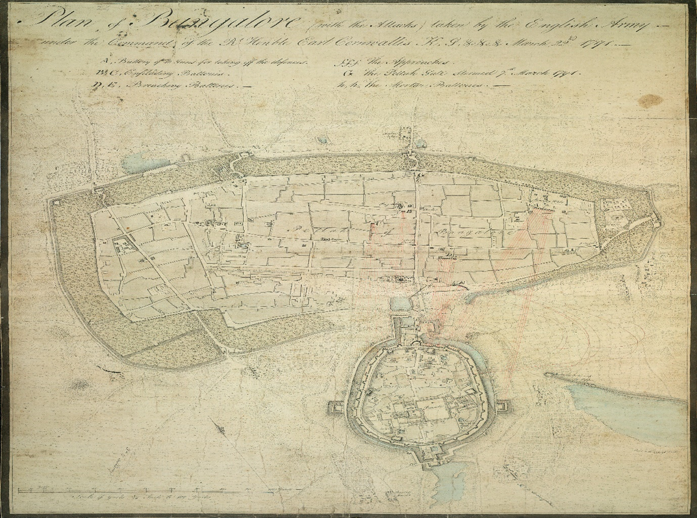
The colonial entry into Bangalore occurred in 1809, when military officials found the nearby swampy islands of Seringampatam ‘unfit for European habitation’. A 50,000 strong garrison established itself near the Halsoor Tank in 1811, accompanied by a host of services provided by natives, including washermen (Dhobies), grocers, porters, construction workers and many others.Footnote 17 A fort, which was the seat of governance for the Mysore king, was situated west of the Halsoor Tank and the cantonment. South of the fort were the two main Pettai or villages, Chika-Pettai and Doda-Pettai, both boasting lively markets for grain, cotton, vegetables and various other items.Footnote 18 The 1875 Gazetteer of Bangalore estimated the population of the two areas combined as 227,425 persons, with Hindus comprising the majority of the population.Footnote 19 Under partial colonial occupation, Bangalore, as Figure 1 shows, was slowly divided into two portions, a colonial cantonment, and multiple native Pettai. The two regions were administered by two boards, one for the cantonment and the other for the town, both under a central municipal commissioner.Footnote 20
Plan of Bangalore fort, 1791.
Source: British Library, IOR/X/14628/48.
This pattern of Pettai and cantonment was often seen in other colonial towns as a division between ‘black town’ and ‘white town’.Footnote 21 The major dividing line, which was racial in nature, for most Europeans was that of sanitation. First, Europeans believed that tropical weather in itself led to disease for the European body.Footnote 22 Secondly, major changes in sanitary works had occurred in European cities in the nineteenth century. As Matthew Gandy shows, the French baron Hausmann and his sanitary engineer rebuilt Paris’ sewers. Concurrently, the Victorian engineer Joseph Bazalgette re-engineered London's sewers and built an embankment across the Thames river.Footnote 23 The ‘sewerization’ of European cities sought to close open drains across the city, and was predicated on conceiving a new relationship between body and city based on health.Footnote 24 Similarly, on the back of the industrial revolution and overcrowding of British cities in the nineteenth century, a major effort at sanitary reform, i.e., the laying of closed sewers, provision of ‘pure’ water and cleansing of waste was attempted.Footnote 25 Thirdly, alongside these sanitary reforms, was the science of contagion and bacteriology. From the 1850s onward, European science, and various theories of contagion that connected disease to the air, animals and eventually water emerged.Footnote 26 These included theories of miasma, or air monsoons, as a disease carrier, forms of germ theory, animal and insect disease vectors and John Snow's theory of water as a carrier of cholera and other diseases.Footnote 27 It was these changes that British colonial officials looked to transpose on cities like Bangalore.
In the late 1860s, the celebrated sanitary commissioner of Madras, J.L Ranking, visited the city of Bangalore.Footnote 28 Ranking's brief was to look into the increasing number of deaths in the Bangalore cantonment, due to a variety of diseases, most likely typhoid. Ranking's visit to Bangalore followed on the heels of a typhoid epidemic, but also a series of other diseases, including cholera, diphtheria and enteric fever. Considering the state of bacteriology, Ranking was not fully sure how these diseases spread.
It is still a disputed point whether the virus of such diseases is a potential agent, an organized germ or particle capable of being diffused by means of the air, or whether it is simply a chemical product of decomposition of filth and matter.Footnote 29
However, Ranking argued that while not widespread, these diseases were endemic to Bangalore, and that it was the characteristics of the city itself that led to disease.Footnote 30 Indeed, he traced the outbreak of typhoid to a lapse at the horse-keepers’ stables. As Colin McFarlane remarked in an article on sanitation in nineteenth-century Bombay, ‘sanitation brought city and nature together’.Footnote 31 While this article proceeds along this theoretical line, little scholarly attention has focused on exploring the sanitary regime in cities outside Delhi, Calcutta and Bombay. While all three were the largest cities in population terms, and the colonial sanitary regimes were broadly similar in nature, the question of locality differed in each space and place. Furthermore, practices of religion, caste and definitions of ‘pollution’ and ‘toxicity’ were at once secular but also differentiated and varied across cities.Footnote 32
While reporting extensively on typhoid, Ranking's report was also a general commentary on the state of the local environment in the cantonment and Pettai. Ranking had visited Bangalore earlier, in the 1850s, to report on diphtheria in the station. Lamenting the lack of conservancy measures:
as a rule, both in the bazaars, and houses in the Cantonments, that the cess-pit system was in operation; that night soil was not removed from the neighbourhood of the dwellings; that in the bazaar it was stored for sale; and that dung heaps were the rule, the refuse of the stables being carefully hoarded for manure of grass lands from successive crops from which tenants looked to defray part of their house rent.Footnote 33
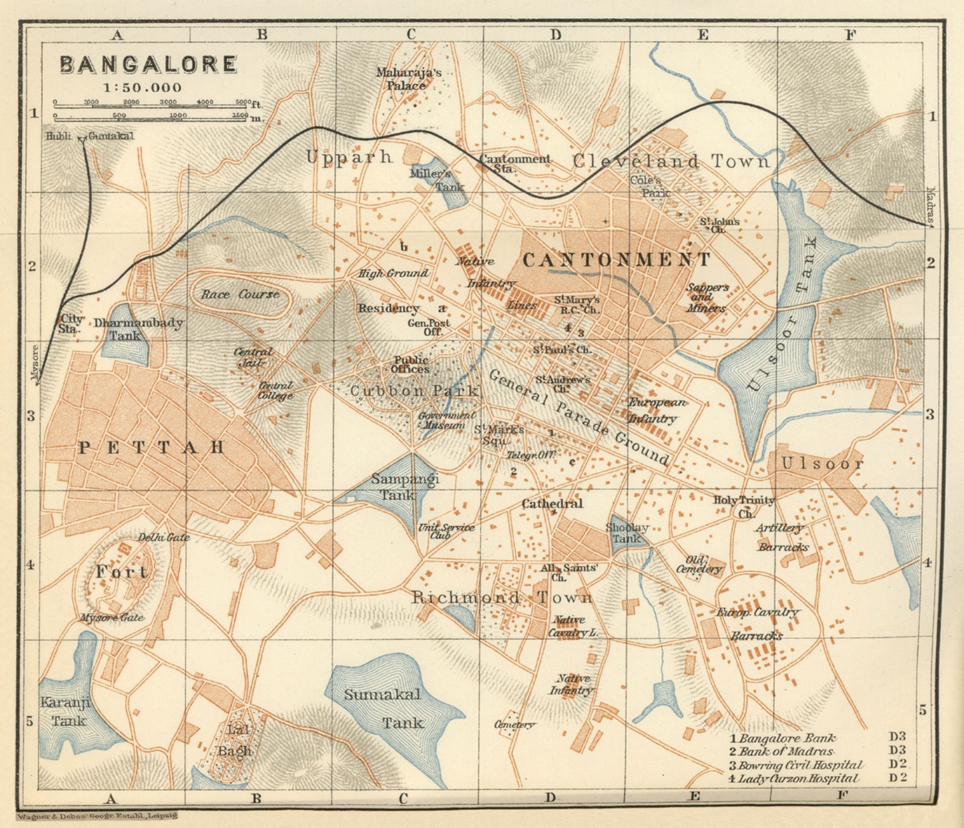
While a new ruling was to come into place in 1870 regulating storage of night soil, Ranking argued that several problems remained in the cantonment and town. The three factors he identifies as responsible for carrying disease within the cantonment were the storage of stable manure, problems with drainage and the location of the houses of the horse-keepers and grass-cutters. The 1870 municipal rules, while regulating human night soil disposal, did not however refer to the subject of storing stable manure. The manure, which was used as a fertilizer on small plots belonging to native officers and retirees in the cantonment, would fetch them additional income. Ranking suggested that there was no ‘question of purity in the atmosphere’ in the presence of manure, and that any attempt to curb this right would be met with ‘determined resistance from the community’.Footnote 34 Drainage was in a much better position than even five years ago. ‘V’ shaped drains were introduced to carry water away from the Ulsoor Tank (marked in Figure 2), which was the principal source of water supply to the cantonment. A channel allowed for sewage to move south of the Domlur Tank, and into ‘lands beyond’.Footnote 35 Further, the horse-keepers’ and grass-cutters’ houses were located on the slope of a ravine within the cantonment. While military authorities attempted to prevent it, the slopes were also used as public latrines, and refuse gathered at the base of the ravine.Footnote 36 In 1865, the village had suffered an epidemic of typhoid, resulting in 106 deaths. The reason was that many afflicted with the fever continuously ‘pour[ed] the contents of their bowels’ into the ravines. Thus, Ranking argued that ‘the whole locality was infected with the germ’, and he had no hesitation in recommending that the houses in the area be removed altogether.Footnote 37
View of ‘Pettah’ and ‘Cantonment’, Bangalore, 1914.
Source: Perry-Castañeda Library, https://legacy.lib.utexas.edu/maps/historical/baedeker_indien_1914/txu-pclmaps-bangalore_1914.jpg.
The greatest jeopardy to public health, however, according to Ranking, was not within the cantonment. Rather, it was the nearby village of Ulsoor. Indeed, Ranking even advocated for the ‘removal’ of the village in order to keep the cantonment free of disease. Ulsoor village was located only 160 metres away from the horse artillery barracks, which housed British troops. It was a village of milkmen.Footnote 38 Ranking pulled no punches in his description of the village:
Every house is reeking with excreta of cattle. In the paved yards urine stands in pools and dung in heaps, while every available square foot of wall is plastered with cowdung in various stages of desiccation in preparation of bratties. The soil is absolutely saturated with filth and the stench is most overpowering…Officers residing near these villages complain that at times the effluvium wafted from them to considerable distances.Footnote 39
Ranking argued that even sanitary improvements proposed by the military would not help the situation. However, he admitted that, shockingly enough, the inhabitants of the village were ‘exceptionally healthy’. Yet, their dirty lifestyles, wandering cattle and proclivity in using the village wastelands as areas of refuse dumping, he suggested, could not be tolerated. The people and their cattle were too ‘proximate’ to the cantonment, Ranking claimed, and had to be removed.
Ranking's report, which several other sanitary reports in subsequent years cited as authoritative, brought together a number of problems that urban space posed for colonial officials. This included native settlements, faecal matter, urine, animals (cattle and horses) and the geography and weather patterns of Bangalore. The health of Bangalore, for colonial officers, was therefore connected to a set of physiological and human and non-human materialities. ‘Improvement’ and modernity could solve some of the health problems faced by the city. Nevertheless, for colonial officials, natives and their animals were only part of a larger problem – that of water.
Water as problem agent
Following Ranking's report on typhoid in Bangalore, C.A. Gordon, principal medical officer of the British armed forces, visited Bangalore and wrote a report on the general sanitary condition of the station. Both Ranking and Gordon devoted considerable space in their reports to examining water.Footnote 40 The way in which water flowed, its tendency to sink into the ground, to carry impurities from one part of town to another, were all concerns for both medical officers. Simultaneously, ‘purified’ water was also the solution to the number of problems that water posed in the city.
Scholars have long recognized the flows of water as critical to the making of urban space. For instance, scholars have suggested that the technologies such as piped water, harbingers of modernity, were imbricated in the socio-cultural fabric of the city, such as the need to put out fires.Footnote 41 Writing on water in colonial Delhi, Awadhendra Sharan argued that the study of water was ‘the first science of the environment’, which focused ‘not so much on the extent of water supply and drainage, and its (in)adequacy in the colonial city, as on concerns around the (im)purity of water, narratives of pollution, technologies of purity and the transformations they effected in a colonial context’. Sharan, therefore, calls for urban history to not simply be reduced to colonial equality. Rather, there were broader (racialized) links that water science drew ‘between urban environments and human health’.Footnote 42 While this article draws on these literatures, it suggests that this link, between urban environments and human health, had both a specific spatial dimension particular to the city, but also articulated a broader idea of piped water supply and housing, closely connected to events such as water famines and new emergent logics of urban expansion. Here, the British military cantonment can be seen to represent a techno-sphere. Its layout was planned. Settlements were carefully constructed, separating the officers' bungalows, native army men's houses and various kinds of worker housing. Furthermore, the colonial government deployed various technologies such as a steam-powered water pump and sand filters to separate and filter the water consumed in certain areas within the cantonment. However, the metabolic city, or the flow of people and substances, continuously disrupted these efforts.Footnote 43
The city of Bangalore got its water supply from a number of sources, including the inter-connected tank system comprising of the Sampengy Tank, Millers Tank, Dharmabudhi Tank, Ulsoor Tank and wells around the city. Geologically, Bangalore was located around 3,000 feet above sea level, and had no perennial river running through it.Footnote 44 The two reports by Ranking and Gordon focused particularly on the state of water supply in the cantonment, and particularly the barracks. The inhabitants in the cantonment were served with water from two different sources, i.e., the Dhobies wells and the Ulsoor Tank. The Sampengy Tank and wells near the race course were a reserve system.Footnote 45 There were 31 wells in all, and the laterite gravel surface meant that water percolated underground from the Ulsoor Tank into the wells. Several wells lost and regained function at different moments. While the water supply was relatively clean according to Gordon, there was little use in increasing the number of wells, and the quantum of water that would be available, drawn using steam pumps, remained the same.Footnote 46 Until 1860, the Ulsoor Tank was the primary source of supply for the wells. It collected rain water from an area of around 3,200 acres, while the tank itself was ‘said to be’ 100 square acres and had a depth of 8–13 feet depending on the season. It supplied troops anywhere between 700,000 to 800,000 gallons of water per month. In addition, as Gordon noted, there was considerable ‘decrease of water by evaporation, by percolation and by consumption on the part of the native population who resort to it in larger numbers than previously believed’.Footnote 47 Furthermore, Gordon observed that prior to its use by British troops for their water supply, the tank was a depository of rubbish for the native population, and would have been entirely filled with debris by 1908.Footnote 48
Numerous reports were authored by medical officers and engineers in the Madras government and the Indian government delving into how the Dhobies wells and the Ulsoor Tank were contaminated.Footnote 49 One well, near the horse artillery barracks for instance, was contaminated through mixing of sewage. The well, which was used by troops, received drainage from the lines of the horse-keepers’ and grass-cutters’ villages. During the dry season, sewage that reached the well was minimal. However, during the rainy season, overflows of the Ulsoor Tank washed sewage from the villages as well the nearby bazaar into the well.Footnote 50 In another case, as a different report observed, one of the wells was located close to the bazaar, and ‘resorted to by cattle’. As a result of the presence of cattle, the well water became undrinkable. However, colonial engineers subsequently dug around the well, laying down a wall made of sand and charcoal, thereby preventing cattle from coming into direct contact with the well. All percolation into the well, the report argued, now passed through a ‘purifying’ medium.Footnote 51 The wells therefore, at different times, were considered pure, but at others closed down or remodelled to ensure water purity.
Most reports, however, were unequivocal that the water from the Ulsoor Tank was contaminated. The problem at Ulsoor lake, as identified early on in 1865, was also seasonal. In the months of February and March, when Bangalore's weather turned hot, decaying vegetable matter found its way into the lake.Footnote 52 For Ranking, the public health crisis caused by impure water was also a result of the behaviour of native troops. Lake water was brought to the barracks and accompanying houses using standpipes. The troops were warned by sanitary engineers not to use the water for cooking or drinking, but only for other domestic purposes such as washing. As Ranking stated, ‘I think it must be admitted that it is more than probable that they drink it also.’Footnote 53 Following Ranking's report, another survey of Ulsoor water 10 years later reached a similar conclusion. The survey traced the origins of the lake water, which passed through ‘streets and alleys, receive[d] the surface drainage and household liquid refuse’, and eventually drained into Ulsoor lake.Footnote 54 A new drainage system that the municipality had constructed diverted some water from an open sewer that emptied into the drain. However, the report confirmed that ‘admission of sewage through apertures in the drain precipitated to the bottom, and the water percolating through the bed so formed carries with it into the deeper soil and a large amount of the products of decomposition’ made Ulsoor lake water unfit for consumption.Footnote 55
Colonial medical officers and engineers relied largely on chemical analysis of water in the city, and identified contaminants on this basis. Ranking largely relied on a method developed by Dr Angus Smith, a chemical advisor to the Army Sanitary Commission, who had conducted experiments in Manchester on clean water, and established a standard.
In sum, Ranking concluded that:
If then the water of the dhobies wells even, be judged by Dr. Angus Smith's standard, it must be pronounced unfit for drinking. Indeed, the same may be said of every water that has been submitted for analysis in this Presidency. None will stand the test…and if we wait will we attain to such purity our troops must, I fear, go without, drinking water at all!Footnote 56
Contamination occurred through flows and percolation of water, the permeation of vegetation and faecal matter into water and air and ‘faulty’ human behaviour, much of which mirrored the tide of urban life.
Other experiments were tried but failed, or were never taken seriously. In 1865, drawing from a successful experiment in Malta, Ellis’ report suggested that rain water be collected on the roof-tops of the barracks, and then stored in underground reservoirs. It was, however, abandoned in favour of the Ulsoor water works project.Footnote 57 Gordon, the then surgeon general, believed that the means to improve water had ‘hitherto been attached to artificial, and too little to “natural” means’. Gordon argued that ‘the purity of water is most effectually assured by the establishment in it of a proper balance of its proper organisms – molluscs and fish to keep down confervae, and certain oxygen evolving plants to induce oxidization of impurities. The presence of aquatic birds furnishes an important means of preserving the balance of life’.Footnote 58 This was a departure and in stark contrast to his own report, and the series of reports on sanitation prior to his own, which had focused on the science of pure water, and its contamination due to urban density and life.Footnote 59
However, purity was not the only concern around water. Availability of water itself was a growing concern for the cantonment and town. From the late 1870s, a famine prevailed across the south of India. Mike Davis, calling the famines ‘The Great Victorian Holocausts’, stated that the Great Famine slowly spread from Madras, and was fully manifested in the Deccan and Mysore by 1875. The drought forced ryots or cultivators, especially smallholders, who dominated the Mysore district to sell their implements, cattle, bullocks and surviving crops, and migrate to towns and cities.Footnote 60 The population of Bangalore city had reduced in number from 1860 to 1870, but grew exponentially afterwards up until 1900.Footnote 61 A year following Gordon's report in 1876 on water resources in Bangalore, a famine was officially declared across Mysore. C.A. Elliot, who would go on to draft the general famine code for all of British India, drafted the first Mysore famine code in 1877.
However, many of the news reports had already observed ‘famine like conditions’ through narratives and impressions of what was going on in the city. One news report, as early as 1876, painted a bleak picture of the city:
owing to the scarcity of water, people in the city are almost in a famine plight. I heard from a friend only yesterday that tanks and principal wells are dry…Cholera I am sorry to say is approaching our cantonment. It seems to be on our Northwest frontier towards Toomkoor and our southwest frontier also.Footnote 62
Cholera was a serious fear as people began drinking water from ditches and puddles.Footnote 63 The situation persisted in the year 1877. In an article titled ‘Scarcity in Mysore’, the same correspondent claimed that little had changed, and ‘no rain had fallen’ since their last letter. The famine, according to the report was also a story of water inequality. While the troops, and even horses, were supplied with water drawn from carts outside Bangalore, little was done to help the booming local population. ‘Water supply’, the article argued, was ‘the question of the day’. In 1878, a correspondent of the Times of India similarly stated that they ‘had never before experienced such weather in Bangalore as we are having now, and the heat is fearful’.Footnote 64 By the early 1880s, police were appointed to guard the Ulsoor Tank to prevent consumption, as well as bathing and any other domestic use by inhabitants outside the cantonment.Footnote 65
The rainfall statistics from the cantonment administrative report backed up these statements. The year 1881–82 was a particularly bad one. From 1876, rainfall had been consistently low, and below average, leading to water shortages. In the year 1881–82, however:
the quantity of rainfall during the year was considerably below the average, it fell short of that by of 1880 by 24.33 inches and of that of the average of the past three years by 12.87 inches. Rain fell on 73 days and was not only deficient in quantity but was very unseasonable, for, during the months of June and July when rain was most needed, only 2 inches in the former and 23 cents in the latter month were gauged.Footnote 66
Broadly, the occurences in Bangalore mirrored George Adamson's and Richard Grove's idea of El Niño as critical to a general crisis during the late nineteenth century in both of Britain's prized imperial colonies, India and Ireland.Footnote 67
The years from the 1860s to the early 1880s saw the development of a close focus on public health as well as mitigating famine. Common to both was the question of water, both its ‘purity’ and availability. Water as an agent, as I have shown in this section, adopted a multiplicity of roles and similarly evoked a multiplicity of responses. The flows (and stagnancy) of water carried along with it rotten vegetation, animal waste, human faeces, bacteria and rodents into the infrastructures of human drinking water, such as pipes. This was rendered possible due to the geological structure and tank-based water supply of Bangalore. The colonial state sought to ‘fix’ the public health of Bangalore cantonment through a variety of measures, including looking for new sources of water, preventing ‘pollution’ and trying to chemically purify water. By 1880, the famine that hit several parts of the global south compounded this problem. That is, water was not only a matter of public health, but also availability.
After the plague
In 1883, at the height of the water crisis, a young medical officer, Dr Ronald Ross, was appointed as the acting garrison surgeon in Bangalore. Ross was a product of the empire, his father having served in the British Indian army. He was, of course, most famous for identifying ‘certain species of mosquitoes as the vectors for transmitting malarial parasites between human bodies’.Footnote 68 After holding other appointments across south India, Ross returned to Bangalore in 1894 to help deal with a severe outbreak of cholera. Like Ranking's and Gordon's reports, Ross’ report was another landmark moment in the history of public health in Bangalore.Footnote 69 Yet, it was different, as for the first time, a major report was not restricted to protecting the garrison. Instead, Ross was clear that the problem of public health was a city-wide issue, and he suggested that public health could only be tackled when understood as such. By the end of the decade, Bangalore became a city that was fighting the bubonic plague. In quick succession, the problem of disease and preserving the ‘healthy body’ became one of urban planning.
Reflecting on his second stint in Bangalore, Ross pointed out the unusual degree to which he was involved with sanitary measures and the Bangalore municipality. Upon arrival, Ross describes how he was granted ‘astonishingly ample and indeed dictatorial powers’. His instructions were to
direct and enforce the sanitary operations conducted by the Municipality in consultation with the Residency Surgeon; to submit a report to the Resident on the present state of affairs…To examine thoroughly the constitution of the Sanitary Department and to suggest in full detail the changes needed to improve its efficiency.
Ross’ report was comprehensive, focusing on conservancy, drainage, water supply and food contamination. While all sections of the report deserve close examination in order to fully understand the imbrication of medical science within urban space, this article will take up only the subject of water, in the ‘native’ part of Bangalore. Ross covered wells and tanks and finally made the case for piped water supply. He began with developing a typology of wells in the city. These included wells in the garden and in open grounds, wells in the streets and wells in native houses and courtyards.Footnote 70 Ross argued that the wells of the cattle-keepers in the city were the most insanitary. The cattle urine and dung not only mixed with the water in the wells, but also the milk supply and vegetables washed in the water from wells. These were sold across the town, and thus circulated cholera, enteric fever and other diseases.Footnote 71 As John Broich has shown, these efforts to close wells, which provided easy access to water, did not go down well with city-dwellers. In addition to providing water for domestic use, well water was used widely for religious ceremonies.Footnote 72 For Ross, however, it was pointless to chemically examine water in over 2,000 wells across the city. His recommendation, not based on ‘scientific’ evidence, but a general observation on the landscape of the city, was to close every single well in the native town.Footnote 73
Ross commented on the way in which water reached houses and its final source in the native town, a subject most other reports had not touched upon. Ross pointed to the water carts, the pots in which water was carried around and the bhishtas (water carriers), who were invariably insanitary when handling water. The taps on pots and carts, he claimed, were usually plugged with a sodden rag.Footnote 74 Every time the rag was removed by a new person, new kinds of bacteria and dirt entered the water supply. The bhishtas’ leather bags were slightly better, but the organic nature of the bags still concerned Ross. Well water was drawn via ropes, brass pots, buckets and tin pans. The ropes, which Ross stated often become ‘soiled with the discharge of patients’, frequently then contaminated entire wells. Poorer families, moreover, used the same vessel for drinking, washing and disposing human waste.Footnote 75
Finally, Ross linked water and water bodies to his favourite subject, malaria. On arrival, Ross was informed that malarial fever was not of great concern in Bangalore. However, having conducted tests across the cantonment and the bazaar areas, Ross concluded that the fever did indeed affect much of the population.Footnote 76 Drawing from Patrick Manson's research, he was clear that water was the agent of contagion. Ross again directed his attention at the ‘pots of water, yards of houses and small puddles of water’ that fostered the parasite. In open tanks, he argued, the malarial parasite was eaten by frogs and small fish.Footnote 77
Ross admitted that bacteria generally did in fact slowly purify inside water. The cholera bacteria for instance, he suggested, lost their potency within the span of three weeks in water. Furthermore, the larger the body of water (well, tank or river) was, and the more exposed it was to sunlight (as opposed to wells and small tanks which were often under the shade of trees), the quicker the bacteria would die. Ultimately, Ross found that ‘the natural forces of purification will not be able to cope with an incessant influx of impurity’.Footnote 78 Ross was, however, not simply reporting upon a situation, but involved uniquely with a municipality that was fast transforming the nature of Bangalore city. He was appointed as a member of the council, and, to his own surprise, found himself giving orders to the municipal public works engineer and sanitation engineer.Footnote 79
Meanwhile, concurrent with the municipality attempting to reshape urban public health was the emergence of a calculative apparatus around water supply. In the 1870s and then 1880s, when concerns around water purity and quantity were growing, Colonel Sankey, an engineer in the Public Works Department, attempted to create a new source of water supply within the city. The reservoir, however, failed as the engineers did not correctly estimate the rainfall run-offs from fields nearby, which were to supply the reservoir with water.Footnote 80 Sankey's scheme, however, was one of the first attempts at calculating the overall required capacity of water for the military and civil stations. Sankey put the capacity of the tank at 47 million gallons of water annually, which could supply 80,000 people 10 gallons of water a day.Footnote 81 This also coincided with the first Census of India undertaken between 1865 and 1872, whereby population estimates became available to engineers.Footnote 82
While exploring the full engineering logic of urban water supply is beyond the scope of this article, the 1880s and 1890s witnessed a major upheaval in municipal investment in water supply schemes. Numerous factors, including the inability of sanitary officials to prevent the contamination of water flows, the famine and diminished rainfall, the failure of the Ulsoor Tank improvement scheme and Sankey's scheme (which were the largest water supply schemes within the city) and the continued contamination of wells for multiple reasons led to a firm conclusion among engineers and sanitary officials that water supply was required from outside the city. Four different schemes were considered, all towards the north of the city.Footnote 83 These were the Hebbal, Rachenahalli, Maligal and Hesseraghatta schemes. Eventually, after much deliberation, Public Works Department engineers, in consultation with the municipality, chose the Hesseraghatta scheme.Footnote 84 Conversely, it now meant that water bodies within the city were available as land to be filled and reclaimed, while wells in courtyards were shut and ordered to be repurposed.
The end of the century witnessed further chaos in Bangalore city. The third wave of the bubonic plague hit the city. While cities on the port were the worst affected, the plague did not spare Bangalore. Bangalore was located at the intersection of four main railway lines, and had three major stations, at the cantonment, city and an area called Yeshwantpur in the north-west.Footnote 85 While attempts were made to check incomers and inoculate them, this proved an impossible task for plague officers. The mortality rate started, in 1899, to approach over 700 persons per week. Disinfection of houses was a priority, but, again, proved an impossibility, and a security apparatus around medical services emerged, in the face of non-cooperation from everyone from undertakers to sweepers.Footnote 86 According to colonial reports, the plague inspired awe and fear, and natives invoked religion as the main way of dealing with death and probably fate that awaited them.Footnote 87 For the newly created plague department however, disinfection, which was the only known way to prevent the spread of the plague, was an onerous task due to the nature of the urban settlement. As one report put it,
The intercourse between them [the cantonment and the city] is so diverse, and so many of the inhabitants of each have ties of occupation or of relationship in the other that it was from the first recognized that one could not escape that if the other were attacked by plague.Footnote 88
As one officer remarked, the plague in effect would have to lead to stripping the city and rebuilding it.
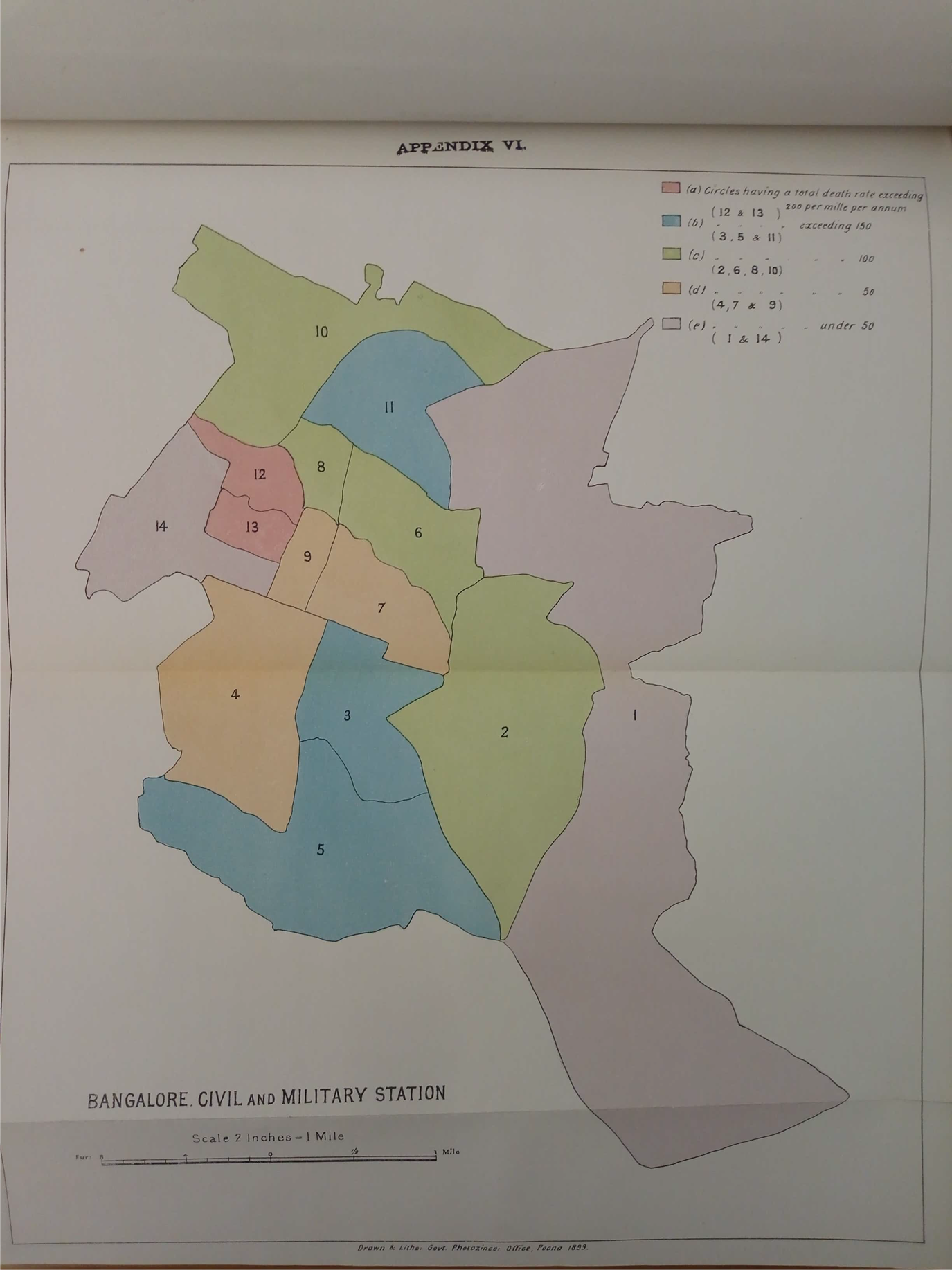
The plague first appeared in Bangalore in 1897, when the first cases were recorded. Figure 3 shows that the plague was most prevalent in the area of Blackpully. Municipal officials were most concerned about infection spreading across houses, streets and railway and bus stations, the spaces of dwelling and circulation that were the nerve centre of the city.Footnote 89 As the plague crisis grew, its management was transferred in October 1898 from the president of the Bangalore municipality to a chief plague commissioner. During the year, the plague severely affected the city, with records showing 3,364 attacks and 2,665 deaths.Footnote 90 The government, under the supervision of the plague commissioner, made several provisions to combat the plague. This section shows how the plague foregrounded new forms of building. Rather than an emphasis on water purity, which had characterized the response to cholera and the famine, sanitary officials focused on housing. The plague, as Sheetal Chhabria has shown in the case of Bombay, did not simply endanger the body, but also networks of circulating capital within the city.Footnote 91
Plague map of Bangalore.
Source: J.H. Stephens, Plague Proof Town Planning in Bangalore, South India (Bangalore, 1914).
The city administration report made it clear that the plague had brought to the fore concerns among residents about their own dwellings. In the year 1900–01, there was a surge in building petitions, and over 700 were approved. These were focused on improvements in lighting, ventilation and replacement of earthen floors with stone. Donald Robertson, the resident during the year, however, believed that the ‘neglect in the past was so bad’ that there remained much to do, especially with regard to congestion.Footnote 92 The Times of India, an English language daily, often representing the views of an emerging native middle class in the city, stated:
During the past three or four years several sanitary experts have reported on the crowded state of the local bazars, including Major Ronald Ross, who was specially deputed here in 1895 during the cholera outbreak. The more recent experience of plague scares has shown that people are not only willing but eager to evacuate their dwellings when an epidemic threatens and in Bangalore plague is now yearly a standing menace.
The report argued that while the municipality had spent vast sums in giving people open sites to build on, little could be done without the aid of the Indian government itself, and that a large-scale reordering of cities was required.Footnote 93
Indeed, when Ross was made sanitary inspector with special powers, he argued in 1897 that municipalities often sought funds for large-scale projects such as drainage and water supply. However, they paid little attention to building, a subject over which they had ample control. A problem Ross identified was that a collective of ‘waste’ was often dumped in heaps in the house yard, including horse manure, garbage and refuse, which ‘soaked the ground with offensive matter’, and proceeded to contaminate wells. The municipality, Ross noted, had powers to pass by-laws, which were precisely designed to ensure compliance, rather than a municipality having to carry out work for which residents would be taxed. The plague rules, which were specific to the two cities of Mysore and Bangalore, had already bestowed on the municipality, powers of emergency removal, modification and right to information.Footnote 94 The new by-laws, prescribed by Ross and adopted by the municipality, went a step further. The municipality forced house-owners to build latrines, and connect them to drains and mechanisms for the disposal of faecal and organic waste. While Ross argued that the requirements and fines were not ‘beyond the means’ of the poorest people, it was hardly so, and large-scale dispossession occurred on account of the by-laws. The rules further reinforced caste prejudice and codified the same. A clause ordered that ‘separate entry shall be made for scavengers (when required by notice) in order to obviate the caste prejudice against such entering by the front door’. Having overcome sustained resistance, Ross hoped that other municipalities would follow the city of Bangalore.Footnote 95
Following the by-laws and plague rules, inspectors and the Sanitary Department used coercive means of evacuation and disinfection to ‘suppress’ the plague. The measure, inspectors found, was popular among people who waited earnestly for the department to find and clear their accommodation of dead rats. In the Civil and Military Station (CMS), Bangalore, between 18 November 1902 and 15 January 1903, a huge staff was deployed for this process, and 16,270 houses were ‘disinfected in a little under than two months’.Footnote 96 In the outlying villages, however, the scenario was different. In the year 1904, only 121 houses were disinfected, and 3,000 odd houses received some form of chemical treatment.Footnote 97 While the municipality and colonial government naturally allocated greater resources to the CMS, disinfecting villages was also a space-based problem. Only villages surrounded by fields, where a temporary camp could be set up, could be successfully disinfected. As Sonali Dhanpal shows, these camps were created as ‘ephemeral architectures’, with little invested in permanent and durable structures. Rather, accommodation in these camps was stratified and divided along race, class, gender and caste lines. The caste and class divisions were particularly stark, with separate kitchens, latrines and even water supply taps for different sections of the camps.Footnote 98
If this was indeed the case, rarely were new cases of plague reported. In contrast, in the CMS, Bangalore, while disinfection was thorough, it was difficult to move people into camps, and they would simply reside in a different neighbourhood temporarily, either spreading the infection, or catching it and bringing it back into the disinfected portion.Footnote 99 For upper-caste residents, this was a ‘pollution’ problem, and camps represented ritual contamination, which superseded catching plague.Footnote 100 This was in effect a double bind. The government was not willing to commit enough resources to thoroughly disinfect villages, and indeed found that unless there were fields that could be occupied with temporary camps, it could not successfully carry out disinfection. In contrast, the rush to disinfect the CMS Bangalore is striking. Yet, to actually preserve immunity in this space was proving practically impossible. Therefore, a slow consensus emerged that regulation of these multiple spaces was an impossibility – and therefore plague proof spatial reordering was the only way out.Footnote 101
Plague was not the only disease that the municipality worried about. Malaria, which was now medically accepted to be spread by the anopheles mosquito, was prevalent, especially in the Blackpully, Benson Town and Cleveland Town areas. In 1905, for instance, two thorough surveys of native regiments were undertaken within the CMS. During the survey, the municipality issued ‘6050 special notices issued for the improvement of private houses against 4003 issued in the previous year. It also prosecuted 1540 house-owners for non-compliance.’Footnote 102 The municipality also began draining wells, pools and pits wherever it was possible to do so, and treating these with kerosene oil. Sanitation officials, in a survey, discovered that maximum breeding occurred in the low-lying grounds near the Shoolay and Millers Tanks and Ulsoor lake. As a result, disinfection was carried out almost every 8–10 days. But this only drove the mosquitoes to laying eggs in the drains, pots and cisterns in houses nearby, which were also disinfected. In all, the municipality used around 500 gallons of kerosene oil for the work, and found that the fever rate came down considerably.Footnote 103
During the years of the plague, the different governments in Bangalore proposed ‘extensions’ in various parts of the city. In order to plan suburban extensions, the Mysore government acquired ‘dry’ agricultural lands south of the large Malleshwaram temple. Yet, in Bangalore, unlike in larger cities like Bombay, the Mysore government subsidized these housing schemes. State servants, especially the clerical classes, who were largely upper-caste south Kanara Brahmins, were given house plots, stratified by income and occupation. In both the extensions, the roads were designed to be one hundred feet wide, tree-lined avenues, open spaces, lines for tramways and conservancy lanes at the back of houses. The ‘makers of new Bangalore’ as one newspaper article christened them, believed that these amenities would make Bangalore an attractive place for wealthy migrants to leave behind colonial towns. Extensions, unlike the town, were also sharply segregated, with Muslim weavers, whose houses were demolished on a large scale due to the plague, allowed to only buy houses in one corner of the extensions.Footnote 104 As the plague commissioner Madhava Rao opined, extensions would ‘bid farewell to the present size of the town’.Footnote 105
As city officials rushed to build new extensions, it was Blackpully, and its teeming bazaars, that once again were central to remaking the city. This area, shown in Figure 4, and located in the north-east of the city, came to be known as Fraser Town. The plan, proposed in the early 1900s, had three central aspects: (1) the creation of a ‘healthy locality’ with the aim of the poor building houses for themselves, (2) the demolishing of congested lanes and houses to create air passages in congested localities and (3) the granting of loans by the state to those who wished to build houses in the extension.Footnote 106 Fraser Town, which was largely Ragi (millet) fields prior to the new extension being laid out, emerged as a sought-after locality among locals. Stephens, who wrote extensively on the plague, praised the ‘capitalist classes’ of Bangalore for making the township. This class, he argued, were not millionaires, but small native artisans and the poorer among the Europeans who decided to invest in housing.Footnote 107 The town itself was comprised of around 400 houses, and several official and non-official members of government were closely involved in its construction. For instance, they recommended builders and contractors. The builders made around a 100 per cent profit from selling their houses, which was in itself financed through government loans.Footnote 108 The town was lauded in the second All India Sanitary Conference as ‘plague proof’, and a model for other towns to construct similar extensions.Footnote 109 Fraser Town was presented as a two-way remedy. Residents were cleared from areas, dispossessed of properties through sanitation and building regulations and were given incentives to reside in new extensions. This new planning regime allowed the city to occupy new lands and created new circuits of capital. One administrator praised the township's ‘civilizing’ functions: ‘The plague, though bad in other directions, has been helpful in this respect, and people, especially the poorest Mahomedans, who were wilful and stubborn before, are beginning to see that sanitation in buildings is a plague preventative, as well as a general improvement to the health all round.’Footnote 110
View of the grid of Fraser Town.
Source: Bangalore cantonment (1920–22) 16" = 1mile.
Source: British Library, IOR/X/9613/3.
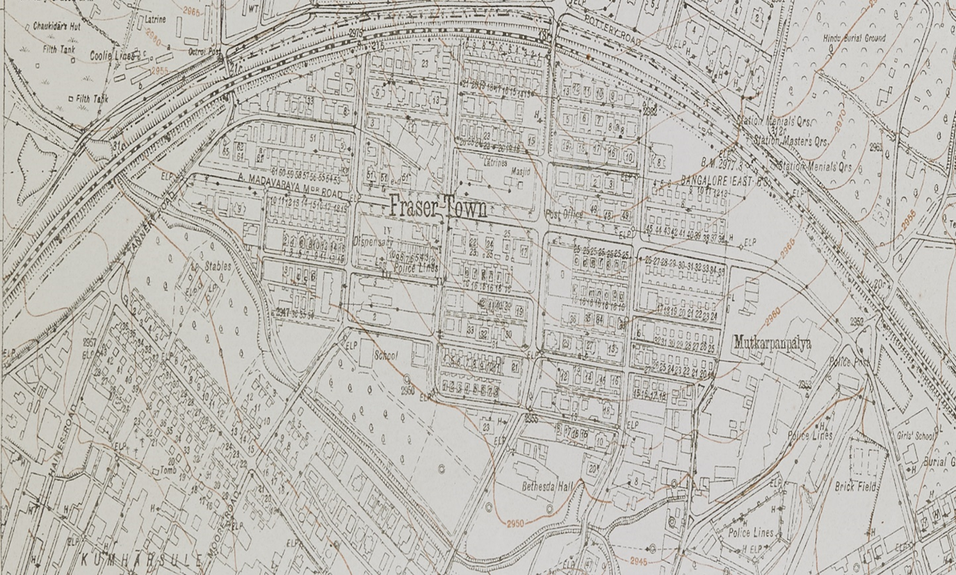
The techno-sphere here operated in two ways. First, the terms ‘extension’ and ‘townships’, which materially manifested in areas such as Malleshwaram, Basavanagudi and Fraser Town, created fixed infrastructure. This was to resolve the environmental conditions that produced contagion. However, these new extensions and townships led to new environmental demands on the city, such as the need for new sources of water supply. Furthermore, as Dhanpal argues, the measures to deal with contagion, and specifically the plague, led to an ephemeral, temporary and intentionally more unstable techno-sphere.Footnote 111 Structures in camps such as hospitals, kitchens, water taps, latrines and housing were all temporary, to be removed when the city recovered from the plague.
Yet, despite the success of Fraser Town, for Stephens, the plague was still a mystery. Stephens argued that the rat was simply the first victim of the plague, and Fraser Town was not an intervention in pathogenic life, but simply preventive. ‘So also, with the plague and the rat. The rat is not the cause; it is merely the first victim.’ Instead, Stephens argued, ‘Enough has been stated to show that there is a wide field for more minute investigations; beginning with mother earth herself and extending right up to the tree tops; from the bottom burrow of the rat hole to the top-most waving branches of the huge Indian Ficus tree.’Footnote 112 The expansion and plague proofing can only solve so much, argued Stephens, and a solution to the plague was about biotic life itself. The environment and non-human life, in a way, seemed to be eating away at the city, and in effect humans. More practically, as another critic of the extensions and suburbs argued, water supply and sanitary drains had not been laid out prior to residents starting construction on housing. This in turn defeated a key reason as to why extensions were laid out in the first place.Footnote 113 Furthermore, the state-subsidized construction boom invited over 5,000 workers to migrate into the city.Footnote 114 In effect, the plague, while decongesting the city, had expanded it into new frontiers, with the city doubling in size.
Conclusion
In conclusion, this article uses the site and specificity of Bangalore city to make three arguments. First, it points to the long-term implications of the emergence of piped water supply schemes for urban environments. Specifically, it locates the logic of the draining of tanks and wells in the logic and grain of colonial public health in the second half of the nineteenth century. If studied over longitudinal time spans, the draining of tanks and wells led to the decline in urban species diversity as well as making new lands available for building, and eventually speculation.Footnote 115 The intense scrutiny of both the health of the city and the famine had consequences for the material space of the city. The consequences, as this article has shown, was on the built form of the city, and its drawing on the resources of a supposedly more pure and controllable countryside. Secondly, it suggests that the continuous public health crisis and consequent search for pure water, which had persisted for over 30 years, was productive in nature. That is, the failure of rainfall and dirt or waste created new fields of power where government and other agencies, such as private builders, operated. The reordering of city space through piped water supply, demolition of housing and rebuilding new neighbourhoods in the form of extensions and townships was made possible due to both a persistent and contingent crisis. Thirdly, the examination of water flows and blocks in the city reveals a theoretical entry-point into urban space, which seeks to bring together ideas of metabolism and techno-urbanism.Footnote 116 For instance, it brings to light the diverse materials used to carry water, such as leather, tin, brass and cloth, all of which were understood to contaminate. However, metabolism as a concept seeks to capture the far more complex ways in which flows, contamination, the city and the body were linked. In the case of the famine years, the unavailability of potable water meant that poorer residents had to consume water from ditches and troughs. Rather than ‘native habit’, produced scarcity of water created conditions for the spread of cholera. Simultaneously, techno-fixes, namely water pipes and housing projects, were deployed as ‘permanent’ solutions to the instability posed by the metabolic city. Yet these new housing extensions and piped water systems resulted in new water flows and inequalities.


 Open access


