




Introduction
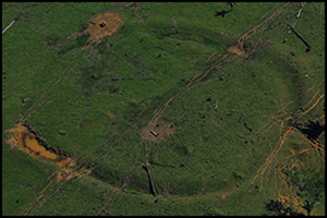
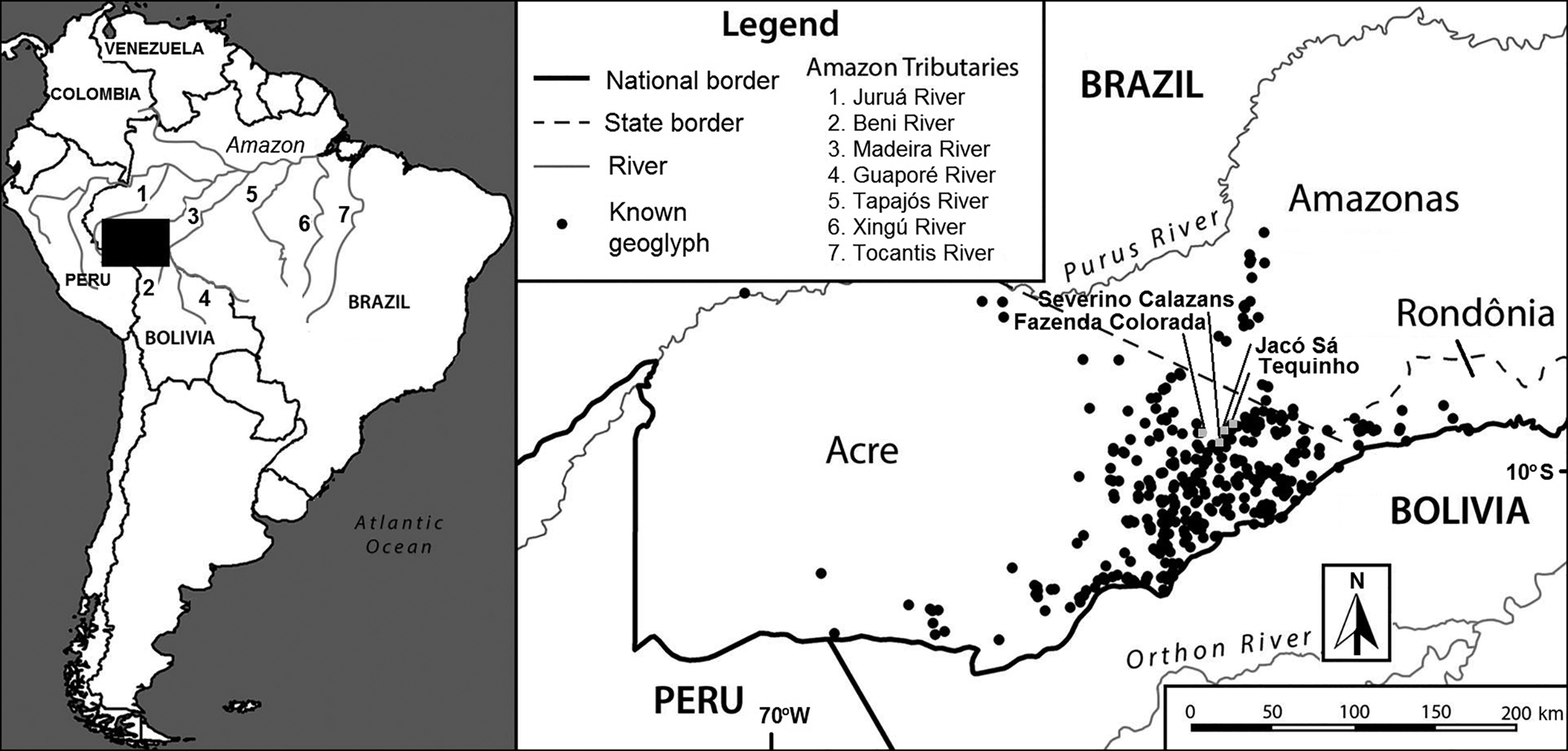
The discovery of hundreds of geometrical earthworks (geoglyphs) with an associated system of roads in the state of Acre, Brazil, has been labelled the “the most recent and dramatic discovery” in Amazonian archaeology (Mann Reference Mann2008: 1148). Together with similar discoveries in the Lower Amazon, Central Amazonia, Xingu, and Mojos and Baures in Bolivia, the Acre geoglyphs have radically changed our understanding of the long-term human impact on the Amazonian rainforest: namely, that the Amazon floodplains and non-flooded terra firme hinterlands were not completely covered by pristine forest (see Balée Reference Balée1989; Denevan Reference Denevan1992; Roosevelt et al. Reference Roosevelt1996; Heckenberger et al. Reference Heckenberger, Kuikuro, Kuikuro, Russell, Schmidt, Fausto and Franchetto2003; Dias Reference Dias, Dias, Carvalho and Zimmermann2006; Erickson Reference Erickson, Balée and Erickson2006; Neves Reference Neves2007; Pärssinen et al. Reference Pärssinen, Schaan and Ranzi2009; Schaan et al. Reference Schaan, Pärssinen, Saunaluoma, Ranzi, Bueno and Barbosa2012). To date, more than 450 prehistoric earthwork sites have been identified in the state of Acre alone (Figure 1), all of which seem to belong to the same ceramic tradition, with affiliations to ancient, Western Amazonian Formative styles. Ceramics dating to c. 2000 BP and resembling other widespread Amazonian styles, including Incised-Rim, Polychrome and Corrugate styles, have also been recovered during excavations of sites, such as Severino Calazans and Tequinho (Pärssinen & Ranzi Reference Pärssinen, Ranzi, Vilaça and Simas de Aguiar2020). Calibrated radiocarbon dates indicate that the first Acre earthworks were initiated by c. 2500 BP, with construction continuing until 1000 BP. Some were still in use at the end of the thirteenth century AD and, according to recent radiocarbon dating, were re-used until as recently as the nineteenth century (Saunaluoma et al. Reference Saunaluoma, Pärssinen and Schaan2018).
The area of known geoglyphs in South-western Amazonia discussed in the text (drawing by S. Saunaluoma, M. Pärssinen & W. Perttola).
Haffer (Reference Haffer1969) initiated the debate on Amazonian savannah formation with the introduction of a biogeographic refuge theory. This theory assumed that the savannah expanded during the cooler, arid glacial periods of the Pleistocene, fragmenting the continuous lowland forest and forming smaller, isolated forest refuges. The resulting isolation stimulated biological differentiation and biodiversity. Our intention here is not to discuss the climatic aridity of the Pleistocene. Nevertheless, Meggers (Reference Meggers1975, Reference Meggers1977) subsequently adopted this theory to explain patterns of cultural and linguistic diversity during the Holocene period, supposing that climatic oscillations would also have affected native lowland forest populations and the observed linguistic differentiation through isolation effects caused by expanding savannahs and isolated forest refuges.
Although Meggers's proposition has gained few followers, some correspondences with global climate fluctuation (especially Atlantic) are documented in the Amazonian evidence. The strength of the Atlantic monsoon winds and displacement of the Inter-Tropical Convergence Zone affect the South American summer monsoon, which usually brings a dry season (at its maximum in July) after a wet season (maximum in January). The circulation system of the South American summer monsoon brings moisture from the tropical Atlantic Ocean across the Amazon Basin (Marsh et al. Reference Marsh, Bruno, Fritz, Baker, Capriles and Hastorf2018), and fluctuations normally cause opposite effects on different sides of the equator, between the southern and northern lowlands. The same may be true for Western and Eastern Amazonia (Marsh et al. Reference Marsh, Bruno, Fritz, Baker, Capriles and Hastorf2018: fig. 2)—a fact that may explain the various contradictory pieces of evidence for wet and dry periods when applied to all of Amazonia (e.g. Cruz et al. Reference Cruz2009: 210; Vonhof & Kaandorp Reference Vonhof, Kaandorp, Hoorn and Wesselingh2010: 204; this article). Although the extent to which Amazonia was covered with savannah during the Pleistocene remains under discussion (e.g. Colinvaux et al. Reference Colinvaux, De Oliveira and Bush2000; Irion & Kalliola Reference Irion, Kalliola, Hoorn and Wesselingh2010), one may speculate as to whether less dramatic Holocene climatic oscillations, compared to the Pleistocene Ice Age, in global temperature and regional precipitation would have been sufficient to turn huge areas of savannah into a neo-tropical biome during the Holocene. While geochemical δ18O isotope analysis from Eastern Amazonia provides independent evidence of regional wetter and drier periods in the Holocene (Cruz et al. Reference Cruz2009), the extent to which this fluctuation changed the vegetation patterns over the entire area remains unknown. Much palaeobotanical evidence for radical climatic change is based on the assumption that the presence of open-land vegetation and charcoal from forest fires provides proof of much drier periods (e.g. Hermanowski et al. Reference Hermanowski, Costa, Carvalho and Behling2012; Carson et al. Reference Carson, Whitney, Mayle, Iriarte, Prümers, Daniel Soto and Watling2014). These circular theories, however, do not take into account the presence of humans in Amazonia throughout the Holocene, and that fires may have been used by Amerindians for clearing forests and maintaining open grasslands (see also Piperno Reference Piperno2011; Bush et al. Reference Bush, McMichael, Piperno, Silman, Barlow, Peres, Power and Palace2015). Amazonia, or at least part of it, was already occupied by the Late Pleistocene period, c. 13 000–10 000 BP, and in the Early Holocene, c. 10 000–8000 BP (Miller et al. Reference Miller1992, cited in Neves Reference Neves2007; Roosevelt et al. Reference Roosevelt1996; Roosevelt Reference Roosevelt2013; Lombardo et al. Reference Lombardo, Szabo, Capriles, May, Amelung, Hutterer, Lehndorff, Plotzki and Veit2013; Watling et al. Reference Watling, Shock, Mongeloâ, Almeida, Kater, de Oliveira and Neves2018a).
While the earthworks sites of Acre have so far yielded no evidence of Pleistocene ash and charcoal accumulations that could have been caused by prolonged natural or anthropogenic fires, thick Holocene ash and charcoal layers are present at many of these sites. In this article, we present evidence for such an accumulation from the Severino Calazans site in eastern Acre, dating to as early as c. 10 000 cal BP, and continuing, with some possible intervals, until the geoglyphs were abandoned. This represents some of the first evidence for an Early Holocene human presence from the Amazonian upland (terra firme)—far from the main riverine routes.
Terra preta vs terra mulata
Over the past 20 years, research on Amazonian Dark Earths—terra preta—has advanced our knowledge of ancient Amerindian landscape management practices, both in riverine bluffs and upland terra firme forests near Amazonia's main riverine routes (see McMichael et al. Reference McMichael, Palace, Bush, Braswell, Hagen, Neves, Silman, Tamanaha and Czarnecki2014a: fig. 1). The dark earths are anthropogenic, highly fertile soils created by centuries of soil mulching over the otherwise poor Amazonian latosols. These anthropogenic black soils were created by Amerindians using fires to produce pyrogenic carbon, which lowers soil pH and gives stability to soil nutrients and micro-organisms (Woods & Denevan Reference Woods, Denevan, Woods, Teixeira, Lehmann, Steiner, WinklerPrins and Rebellato2009). Although the presence or absence of dark earths has also been used in Amazonian studies as a measure of human occupation density (e.g. McMichael et al. Reference McMichael, Piperno, Bush, Silman, Zimmerman, Raczka and Lobato2012), it seems to be absent in Acre. Watling et al. (Reference Watling2017) have nevertheless proposed that at least 4000 years ago, the first inhabitants of Acre created small open patches within forests by burning, in order to attract useful trees, such as palms, long before the first earthwork-building projects commenced. Furthermore, the presence of only a few imported, small stone axes found during our archaeological investigations indicates that no local, large-scale tree-cutting activities were undertaken. Indeed, the cultural landscape may have been created through the use of controlled burning. An anthropogenic forest, for example, covers the geoglyph of Três Vertentes. This forest comprises numerous palm species, along with semi-domesticated and domesticated dicotyledonous species, including Brazil nuts (Bertholletia excelsa), rubber trees (Hevea brasiliensis), caucho (Castilla ulei) and numerous moraceous (fig family) vines and trees (Balée et al. Reference Balée, Schaan, Whitaker and Holanda2014)—a ‘legacy’ of the geoglyph-building societies of the past (Watling et al. Reference Watling2017; Watling et al. Reference Watling, Mayle and Schaan2018b).
According to Watling et al. (Reference Watling2017; see also Watling et al. Reference Watling, Mayle and Schaan2018b), the earliest fires in the geoglyph region have been recorded at the Fazenda Colorada site, dating to c. 4701–4535 cal BC. In addition, Watling et al. (Reference Watling2017) recorded a piece of charcoal giving a radiocarbon age of 6984±33 BP (5981–5770 cal BC, according to the corrected IntCal13 calibration curve used by Watling et al. Reference Watling2017), although the authors question the reliability of this date due to the sample's uncertain stratigraphic position. While no human artefacts were found at Fazenda Colorada, burning activities increased on such a large scale from 4500/4000 BP onward (Watling et al. Reference Watling2017) that they were undoubtedly associated with human presence and intentional landscape modifications, including a decrease in bamboo and an increase in edible trees such as palms. The notion of a 4500-year-old human presence in Acre had been previously proposed by Schaan et al. (Reference Schaan, Pärssinen, Saunaluoma, Ranzi, Bueno and Barbosa2012) based on our initial radiocarbon evidence from the Severino Calazans site. Indeed, we suggest that the local inhabitants seem to have used these former grassland patches as favoured sites upon which to build ditches, embankments and roads.
In this article, we present supporting evidence that the geoglyph-building populations of Acre used fire in their horticultural practices and for clearing vegetation from ceremonial sites. Although this activity did not produce Amazonian dark earths, the result resembles lighter-coloured terra mulata soil (see e.g. Denevan Reference Denevan2001; Kämpf et al. Reference Kämpf, Woods, Sombroek, Kern, Cunha, Lehmann, Kern, Glaser and Woods2003; Arroyo-Kalin Reference Arroyo-Kalin2010), containing ash and tiny fragments of charcoal accumulated over a long period of time. While this soil is less fertile than dark earth, it has a comparably low pH and stabilises soil nutrients. Our primary research questions stem from this interpretation. If we accept that Acre had savannah-like patches at least 4000 years ago (or even much earlier), then an obvious question concerns whether the region had larger anthropogenic savannah formations, such as those found widely today as a result of current burning activities conducted by modern ranchers and farmers. Or were these pre-Colonial savannah areas created by climatic change, as proposed by Pessenda et al. (Reference Pessenda, Gomes, Aravena, Ribeiro, Boulet and Gouveia1998) and Carson et al. (Reference Carson, Whitney, Mayle, Iriarte, Prümers, Daniel Soto and Watling2014) in reference to the pre-Colonial open grassland in nearby areas of Brazilian Rondônia and Bolivia? Finally, when did the first Holocene savannah-like patches appear in the geoglyph zone of Acre? These questions are critical, as they relate to the much broader and strongly debated issue of climatic fluctuation and its effects on Amazonian vegetation, biodiversity and human history.
Excavations at the Severino Calazans site
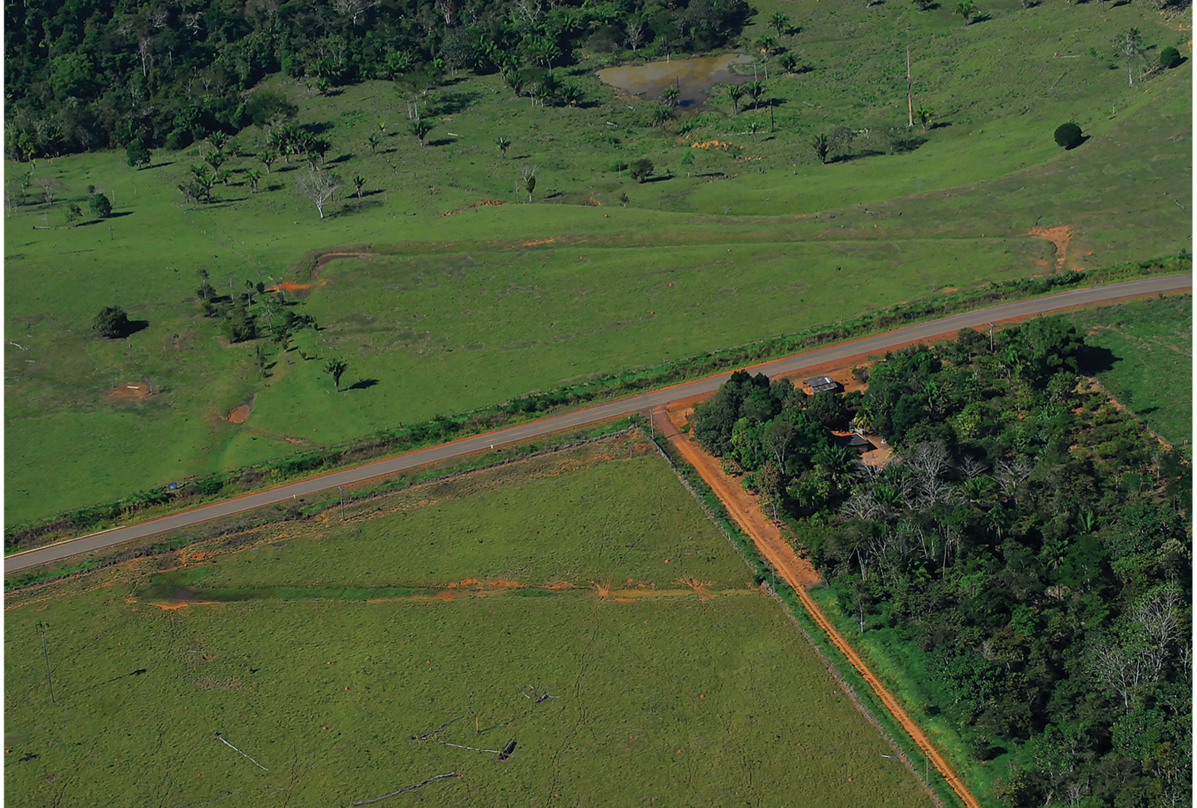
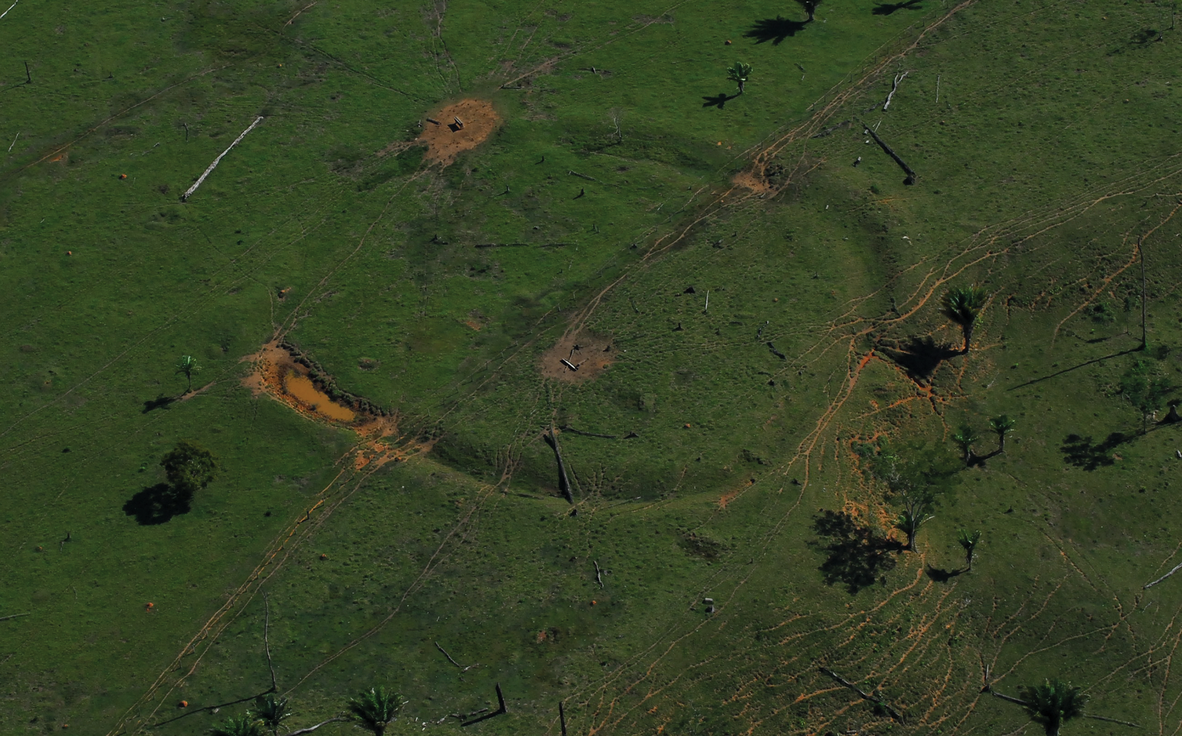
The Severino Calazans site comprises a square, ditched enclosure, 230 × 230m that is bisected and partially destroyed by the modern BR-317 highway (Figures 2–3). The 12m-wide ditch was dug on a plateau adjacent to a slope that descends towards the Iquiri River. Most of the sediment excavated from the ditch was used to build an external bank. Originally, the ditch would have been more than 5m lower than the top of the bank. Attached to the north side of the main structure is a 100m-wide, earthen enclosure, with an 8m-wide entrance at its northern mid-point. Approximately 700m to the south of the main enclosure is an archaeological site known as Severino Batista (Figure 4), which comprises a sub-circular ditch approximately 80m in diameter, with rounded corners. The ditch is flanked by earthen banks.
Aerial photograph of the Severino Calazans site, looking south (photograph by D. Gurgel).
Plan of the earthworks at Severino Calazans (drawing by M. Pärssinen, S. Saunaluoma & W. Perttola).

Aerial photograph of the Severino Batista earthwork (photograph by D. Gurgel).
During our initial excavations at Severino Calazans in 2007, we noticed that the ash and charcoal accumulation was surprisingly deep on the western side of the site. In this area, we also discovered a circular, approximately 0.20m-wide pre-Ceramic hearth feature, 1.10m below the ground surface (pit 4). In 2014, and later in 2017–2018, additional trenches and test pits were excavated in different parts of the site to refine the chronology of Severino Calazans. In total, four trenches measuring 12 × 1m (trenches 6A-F, 7A-F, 20A-F) and 12 × 2m (trench 13A-F), and eight pits measuring 2 × 1m (pits 1–5, 8, 9 and 10) were excavated. We also excavated a further six 1 × 1m pits (pits 11–12 and 14–18), and two 2 × 2m pits (19A–B) to the south, west and north of the enclosure. At nearby Severino Batista, we excavated two 1 × 2m pits (pits 1–2). The trenches and all of the pits except pits 11 and 15–18 contained cultural remains, predominantly comprising undecorated ceramics and burnt clay, along with occasional fragments of grinding stones and burnt bone fragments. It is notable that whenever cultural layers with associated ceramics were identified, they always continued well below the level containing ceramics and burnt clay, often without any observable change in the soil colour until sterile soil was reached.
In general, the modern greyish surface layer of the Severino Calazans site was 0–0.10m thick (Figure 5). Below this was a 0.10–0.60m-thick layer of yellowish red (5YR 5/8; 5YR 5/6 by the Munsell soil colour chart) or reddish yellow (5YR 6/8)/strong brown (7.5YR 5/6) soil, often containing ceramics, burnt clay, occasional fragments of grinding stones, bones, charcoal, macrofossils and ash. This anthropogenic layer and materials resemble terra mulata and are generally representative of ancient activity at the site. Beneath this was a 0.10–1.20m-thick layer of red (2YR 4/6; 2.5YR 5/8) or yellowish red (5YR 5/8; 5YR 5/6) soil that also resembles terra mulata. This layer contained small fragments of charcoal, ash, gravel and small conglomerate pebble stones, as well as occasional pieces of amber and fossilised wood. The layer's upper part (varying in depth between 0.10 and 0.60m) contained few ceramic sherds. The underlying aceramic section varied in depth from 0.10–0.90m. The only exceptions to these measured depths were observed at the deepest points of the three trenches, where the ceramic-containing layers reached approximately 4.70m below the current ground's surface due to the presence of an ancient ditch. Finally, the sterile soil layer was a red colour (2YR 4/8), with mixed clay and gravel, or with light yellowish-brown silt spots (2.5Y 6/4).
The western profile of pit 19A and the locations of four radiocarbon samples (denoted by the star symbols) listed in Table 1 (drawing by M. Pärssinen).

Radiocarbon dates with δ13C values (Bronk Ramsey Reference Bronk Ramsey2009; Hogg et al. Reference Hogg2013) from Severino Batista and Severino Calazans (all collected by M. Pärssinen). All the pits, except 1, 17 and 18, are denoted on Figure 3.

Radiocarbon dates
Samples for radiocarbon dating were collected in 2007, 2014, 2017 and 2018 from the Severino Calazans and Severino Batista sites. These were analysed in the Ångström Laboratory of the University of Uppsala, and calibrated using the OxCal v4.3 program, using the SHCal13 curve (Bronk Ramsey Reference Bronk Ramsey2009; Hogg et al. Reference Hogg2013). The results are shown in Table 1.
The two samples (Ua-59605 and Ua-59604), taken from pits 19B and 19A, at 1.34m below the surface, provide dates of 8238–7844 and 8203–7721 cal BC (at 95.4% confidence), respectively. No lithics or other artefacts were discovered in this layer. Nevertheless, in the western profile of pit 19A, a greyish soil lens stained by clay, ash and small pieces of carbon—as is often found in human settlement sites in the Andes and Amazonia (see Pärssinen & Siiriäinen Reference Pärssinen and Siiriäinen1997: fig. 3; Schaan Reference Schaan2004: figs 37, 45 & 47)—was recorded at the same level, approximately 1.30m below the surface (Figure 5). Furthermore, a sample (Ua-50106) taken from pit 12 (Figure 6), approximately 0.10m above the sterile soil layer, gives a date of 7543–7190 cal BC (at 95.4% confidence). Again, no human artefacts were present in this layer. Unfortunately, it seems that not even similar durable lithic artefacts to those found, for example, at Rondônia (Watling et al. Reference Watling, Shock, Mongeloâ, Almeida, Kater, de Oliveira and Neves2018a) were used at Severino Calazans. This is perhaps unsurprising, however, given the lack of local, natural lithic sources. Nevertheless, as the date derives from the lower section of the very same soil layer that included ceramics in the upper section, it is probable that the soil accumulated due to human activities. Furthermore, the date fits into the chronological sequence provided by sample Ua-50102 (5999–5757 cal BC) taken from trench 7, approximately 0.50m above the sterile layer.
The northern and western profiles of pit 12 and the locations of four radiocarbon samples (denoted by the star symbols) listed in Table 1 (drawing by M. Pärssinen).

Currently, we have no evidence for soil accumulation between c. 4000 and 3000 cal BC. Evidence for fires and the presence of a (new?) intensive phase of soil and ash accumulation began c. 2872–2581 cal BC and continued, with fluctuating intensity, until cal AD 681–876. In addition, four ceramic-associated radiocarbon samples from pit 20A provide evidence that the initial construction of the embankments situated inside of the current ditches may have started c. 751–402 cal BC. Finally, various samples indicate that the current ditched geoglyphs at Severino Calazans (samples from pits 3, 6B, 12, 13C, 13D, 14) and Severino Batista (sample from pit 1) were built and used between c. 350 BC and AD 850. Together with the radiocarbon dates and stratigraphy from Severino Calazans described above, these samples further support pre-ceramic human activity in the region, even though we have found no pre-ceramic lithic tools. With the exception of occasional fragments of non-local grinding stones, lithics were also absent from the upper ceramic-bearing layers. Most of the tools and utilitarian objects were therefore probably made from local, organic materials.
In summary, we can propose no explanation for the accumulations of ash and charcoal at the Severino Calazans and Severino Batista sites, other than that they must have resulted from periodic, anthropogenic burning episodes. Although we have excavated test pits down to 3m below the darker, ash- and charcoal-containing ‘cultural’ soil, no charcoal has been recovered from these sterile soils. Thus, the accumulation of the soil containing ash and charcoal is definitely a Holocene phenomenon. The two oldest samples—from pits 19B and 19A—give dates of 8238–7844 and 8203–7721 cal BC, respectively. Hence, the first inhabitants may indeed have arrived in the region c. 10 000 years ago. Compared to Watling et al.'s (Reference Watling2017) evidence of heavy landscape transformation occurring during the transition period between the Middle and Late Holocene (4500/4000 BP), this process seems to have started centuries later at Fazenda Colorada and Jaco Sá than at Severino Calazans.
Whereas a period of intense burning began at Fazenda Colorada and Jaco Sá c. 4000 BP (Watling et al. Reference Watling2017), at Severino Calazans, such activity had already started by 4500 BP (Table 1). Thus, the timing of these landscape-transforming activities appears to be localised and varied. Nevertheless, it is notable that Pessenda et al. (Reference Pessenda, Gomes, Aravena, Ribeiro, Boulet and Gouveia1998) recorded similar but larger-scale soil accumulation processes over the past 7000 years in Rondônia. Although Pessenda et al. (Reference Pessenda, Gomes, Aravena, Ribeiro, Boulet and Gouveia1998) considered that these accumulations resulted from climatic change and natural fires, the presence of humans in Rondônia 10 000–9500 years ago (Watling et al. Reference Watling, Shock, Mongeloâ, Almeida, Kater, de Oliveira and Neves2018a) suggests that at least part of the accumulation process at Rondônia may be attributable to human activity. There is no evidence at Severino Calazans for natural accumulation, as there was no observable change in soil composition between the lower pre-ceramic ash-and-charcoal layer and the ceramic-containing layer. It is also notable that the soil-accumulation thickness varied greatly in different pits, indicating the localised and controlled use of fire.
Carbon isotope δ13C fluctuation and supposed climate change in South-western Amazonia
Earlier we demonstrated that the accumulation of anthropogenic soil in Acre seems to have started at the beginning of the Holocene. In this section, we analyse geochemical evidence for Acrean forest structures across the entire Holocene according to data obtained from carbon isotope (δ13C) records from our radiocarbon samples from Severino Calazans and other archaeological sites in the region. If the first savannah-like patches had already appeared c. 10 000 years ago in Acre, do we have evidence of much drier climatic periods in the Holocene that would have accelerated environmental change towards the vast open savannah? As will be seen, the answer seems to be ‘no’.
Researchers have traditionally studied climate oscillation by using variation in oxygen isotope (δ18O) values of, for example, cave stalagmites and lake sediments. Seltzer et al. (Reference Seltzer, Rodbell and Burns2000) note that fluctuations in δ13C ratios correspond strongly with the variations in δ18O values. In particular, it has been found that δ13C values predominantly reflect precipitation, with higher values indicating less precipitation and lower values, reflecting more humid conditions (e.g. Kohn Reference Kohn2010). Most of the world's vegetation comprises C3 plants, including our samples of Amazonian vegetation and their seeds. These have their own δ13C standards (O'Leary Reference O'Leary1988: 334) that vary normally between −20 and −37‰. C3 plant values above −23‰ are restricted to very dry environments, such as savannah and desert. Furthermore, in savannah, subtropical grasslands and seasonally flooded tropical environments, C4 plant species may dominate. Their δ13C values are higher than C3 plants ranging between −9 and −16‰ (Pessenda et al. Reference Pessenda, Gomes, Aravena, Ribeiro, Boulet and Gouveia1998; Kohn Reference Kohn2010; Hermenegildo et al. Reference Hermenegildo, O'Connell, Guapindaia and Neves2017).
It is notable that the δ13C values of our samples from Severino Calazans (predominantly small charred branches and sticks) indicate no significant changes in precipitation during the 10 000–1100 cal BP time period (Table 1). Hence, there is no evidence for a major shift in vegetation towards open savannah. On the contrary, C3 vegetation of the forest environment continued to dominate and the small, savannah-like patches seemingly did not greatly affect the general forest composition—not even during the geoglyph-building period. Similar results have been obtained for the Late Holocene period at Fazenda Colorada and Jaco Sá (Watling et al. Reference Watling2017, Reference Watling, Mayle and Schaan2018b).
The same interpretation applies for the values of other samples collected by us and our colleagues from different archaeological sites dating from 1631 cal BC–cal AD 1891 in eastern Acre and from nearby areas of tropical northern Bolivia (Siiriäinen Reference Siiriäinen, Siiriäinen and Korpisaari2003; Schaan et al. Reference Schaan, Pärssinen, Saunaluoma, Ranzi, Bueno and Barbosa2012; Saunaluoma Reference Saunaluoma2013: 30–31; Saunaluoma et al. Reference Saunaluoma, Pärssinen and Schaan2018). Of these additional samples, the only exception derives from the site of Balneário Quinauá in Acre, excavated by Saunaluoma (Reference Saunaluoma2012). There, one sample (Ua-37260), dated to cal AD 431–602, gives a value of −13‰, which is typical of dry regions, such as Bolivian Chuquisaca. Nevertheless, this particular sample was obtained from the sooted surface of a ceramic sherd (Saunaluoma Reference Saunaluoma2012), and may originally have derived from a C4 plant such as maize, which was known to be exploited at the nearby Tequinho geoglyph site in Acre (Watling et al. Reference Watling, Saunaluoma, Pärssinen and Schaan2015). Other than this outlier, all the values from our total of 78 samples from South-western Amazonia fluctuate around −27‰ (consistently −23 to −30.6‰), without any clear long-term trends observable. The variation is comparable with the results derived from forest and forest-transition regions of the adjacent state of Rondônia, but differ radically from drier wooded savannah (cerrado) and tropical, semi-deciduous forest (cerradão) sites in Rondônia. This is probably due to the radically different type of vegetation (C4 plants) (Pessenda et al. Reference Pessenda, Gomes, Aravena, Ribeiro, Boulet and Gouveia1998).
Conclusions
Excavations in Severino Calazans produced new evidence of Early Holocene human presence in the interfluvial terra firme tropical forest region of South-western Amazonia. It appears that below the known geoglyph was a cultural layer that pre-dates the geoglyph by more than 7000 years. Periodical forest burnings produced anthrosol that resembles terra mulata. Apparently these kinds of soil patches were used as favoured sites upon which geoglyph-type ditched embankments were built.
During our excavation, we collected samples for radiocarbon dating and carbon isotope (δ13C) measurements covering c. 9000 years. By combining these data with earlier measurements (Siiriäinen Reference Siiriäinen, Siiriäinen and Korpisaari2003; Schaan et al. Reference Schaan, Pärssinen, Saunaluoma, Ranzi, Bueno and Barbosa2012; Saunaluoma Reference Saunaluoma2013: 30–31; Saunaluoma et al. Reference Saunaluoma, Pärssinen and Schaan2018; this article) covering more than 3000 years, we can argue that the geochemical δ13C data show no obvious long-term changes in precipitation or in the tropical forest composition in eastern Acre or northern Bolivia. On the contrary, the evidence presented here strongly indicates periodic and repeated low-intensity burning events that opened small savannah-like patches in the tropical forest of eastern Acre throughout the entire Holocene. More precisely, our radiocarbon dates indicate that by the Early and Middle Holocene (c. 10 000–4200 BP), this part of Amazonia may already have been populated, and small patches of the tropical forest (including bamboo-dominated C3 forest; see McMichael et al. Reference McMichael, Palace and Golightly2014b) may have been opened for human purposes. Watling et al. (Reference Watling2017, Reference Watling, Shock, Mongeloâ, Almeida, Kater, de Oliveira and Neves2018a) note an increase in the number of phytoliths of edible palms after each Late Holocene major fire event at the Fazenda Colorada and Jacó Sá sites. The same probably occurred at Severino Calazans, which yielded evidence for edible oricuri (Attalea phalerata) and peach palm (Bactris gasipaes), as well as Brazil nut (Bertholletia excelsa), during our archaeological excavations. Even today, these three species, along with ivory nut palm (Phytelephas macrocarpa), are commonly encountered close to ancient geoglyphs (Virtanen Reference Virtanen, Hornborg and Hill2011).
Ancient Acrean land-use techniques may have been comparable with those of the modern indigenous Kayapó (Posey Reference Posey1985; Hecht & Posey Reference Hecht and Posey1989; Denevan Reference Denevan2001: 68–69), which include intensive swiddening to clean and fertilise agricultural patches. This technique was based on the annual use of controlled burning of the upland (terra firme) forest in regions of moderate or high seasonality, mixing dry and fresh vegetation. This system is still used by some local Indigenous people, such as the Manchineri and the Apurinã in the states of Acre and Amazonas (Pirjo K. Virtanen, pers. comm.).
We are aware that the evidence presented here is not yet conclusive and that we require more archaeological data and additional radiocarbon and carbon isotope δ13C measurements from Western Amazonia. In every instance, however, our results so far clearly suggest the potential need for the re-evaluation of previous studies, which assume that charcoals are evidence for radically drier periods in the South-western Amazonian Holocene and do not take into account the possibility of anthropogenic activity. Further, such a re-evaluation may also have consequences for our understanding of Amazonian climate change and even for the modelling of past climate fluctuations on a global scale.
Acknowledgements
Denise Pahl Schaan co-directed the research project, but passed away in 2018. In Brazil, the research was authorised by the Instituto do Patrimônio Histórico e Artístico Nacional (IPHAN). The University of Helsinki, Instituto Iberoamericano de Finlandia, Universidade Federal do Acre, Universidade Federal do Pará, Prefeitura de Rio Branco and the Governo do Acre also contributed to the project. We wish to thank them all for their support.
Funding statement
The research on pre-Columbian geometric earthworks in the Western Amazon was funded by the Academy of Finland (decisions 2567481 and 297161).


 Open access

