




Introduction
For sailing, 12 August 1993 was certainly not an ideal day. The sea was still rough as typhoon Robyn had just passed by. Nevertheless, the ocean scientists who gathered at the port of Busan in South Korea were eager to embark on a cruise over the bumpy sea. Aboard the research vessel Professor Khromov, Russian crews from the Far Eastern Regional Hydrometeorological Research Institute (FERHRI) were preparing the ship for the voyage. Masaki Takematsu and his colleague from Kyushu University were loading the current meters they hoped to moor in the deep waters beyond the Russian border. Kuh Kim and his students from Seoul National University were busy testing the winch and rosette bottles, which they would use to collect seawater samples.
Together, the international team of Korean, Russian, and Japanese oceanographers travelled across the national boundaries of the East Sea (also known as the Sea of Japan, hereafter the East Sea). From Busan to near the Tsugaru Strait of Japan, and then to the waters off the coast of Vladivostok, Russia, they collected samples of seawater and measured their chemistry (Figure 1). They named their research CREAMS, an acronym for Circulation Research of the East Asian Marginal Seas. The first phase of CREAMS international cooperation, which lasted from 1993 to 1996, resulted in a fascinating finding that the oxygen-rich water at the bottom of the East Sea has decreased over the past few decades.Footnote 1 This result drew significant attention from the international oceanographic community, as it was regarded as direct evidence that atmospheric climate change is affecting the chemical make-up of the ocean. CREAMS scientists argued that the small basin could be considered a ‘natural laboratory’ or a ‘miniature ocean’, a scale model to predict the fate of global oceans in a rapidly warming world.Footnote 2 In 1996, US scientists joined the second phase of CREAMS to further explore the oceanic circulation of the region, making the small, marginal sea an unexpected epicentre of international scientific collaboration on global climate change.Footnote 3
The cruise route of R/V Professor Khromov for the CREAMS research in 1993. Kuh Kim et al., Tonghaeŭi haesu mit mulchilsunhwane kwanhan yŏn’gu (Kwahakkisulch’ŏ, 1995), 5.

Figure 1. Long description
The map illustrates the cruise route of the research vessel R/V Professor Khromov during the CREAMS research conducted in 1993. The route spans the East Sea, also known as the Sea of Japan, covering areas from Busan in Korea to near the Tsugaru Strait of Japan, and extending to the waters off the coast of Vladivostok, Russia. The map includes various symbols indicating different types of measurements: CTD (Conductivity, Temperature, Depth), Surface Chemistry, Full Chemistry, CM Deployment, and Drifter locations. Key labeled locations such as 16, 45, 30, 27, 20, 15, 53, 69, 89, 38, K1, 9.7, 6, 80, 76, and 8 are marked along the route. The map provides a detailed overview of the international collaborative effort involving Korean, Russian, and Japanese oceanographers to collect seawater samples and measure their chemical properties.
What made CREAMS especially interesting was that it was a rare case of international cooperation in a region long characterized by intense geopolitical struggles. Surrounded by four historically conflicted nations—South Korea, North Korea, Russia, and Japan—the East Sea has been a stage of intense territorial struggles throughout the Korean War and the Cold War.Footnote 4 Despite vast oceanographic interests in this region, a complete scientific survey of the East Sea has been practically impossible due to the difficulty of moving across national boundaries. CREAMS cruise was certainly a rare form of scientific cooperation that overcame the historically sustained geopolitical tensions. As two US scientists aptly exclaimed in 1996, ‘given the political differences that have existed in this part of the world over most of the twentieth century, it is heartening to see the beginning of important international collaborations in the region’.Footnote 5 CREAMS, in short, was a victory of borderless natural science over geopolitical conflict.
A closer inspection, however, reveals a more complicated relationship between geopolitics and transboundary ocean science. Like any other geoscience in conflicted regions, CREAMS was never insulated from the geopolitical context of the time. What international teams of scientists could and could not research in the 1990s was often circumscribed by shifting diplomatic situations from the collapse of the Soviet Union to the establishment of the Exclusive Economic Zone (EEZ). In order to make their research possible, the international team of scientists had to devise various tactics to cope with the complicated border problems. This involved cleverly designing the cruise routes of their research vessels as well as actively aligning their research with nation-specific motives. When presenting their work to international oceanographic communities, on the other hand, the scientists framed East Sea oceanography as an apolitical study of the global ocean by utilizing the imaginary of ‘natural laboratory’ and ‘miniature ocean’. In sum, CREAMS was made possible, not solely by the border-crossing friendship, but also by the various tactics of international scientists to circumvent and even appropriate the geopolitical tensions.
In this article, I argue that new geoscientific knowledge about the East Sea was constructed as the ocean scientists devised material, political, and rhetorical strategies to bypass and utilize its geopolitical conflicts.Footnote 6 For CREAMS scientists, navigating geopolitical hurdles was a core challenge of transnational geoscience as much as actually steering ships across turbulent waters. How well the international team coped with the territorial tensions directly shaped what they could and could not know about the basin. The case study on East Sea science highlights territorial conflicts and diverse strategies to manage them as critical factors that shape the production of transnational scientific knowledge. It also contributes to global maritime history by suggesting conflicted marginal basins like the East Sea as promising stages to observe transnational mediation and confrontations.
In examining the history of transnational ocean science in East Asia, this article draws upon literature that has studied how geopolitical conditions have shaped the course of border-crossing scientific research throughout the Cold War and post–Cold War eras. Challenging nationalistic narratives on Cold War science, recent literature has analysed how the context of global rivalry structured the mobility of scientific knowledge beyond national boundaries.Footnote 7 Between the US and the Soviet blocs, concerns about national security have challenged border-crossing scientific cooperation.Footnote 8 The Cold War conflicts, however, did not completely prevent transnational collaborations between the competing blocs.Footnote 9 International organizations and politically neutral states served the role of mediators for transboundary cooperation in nuclear physics, nuclear medicine, and meteorology.Footnote 10 The literature has also highlighted the lived experiences of transnational scientists who managed to work across borders under severe geopolitical tensions by reconfiguring their political identities and reframing the implications of their work.Footnote 11 Rather than considering geopolitical boundaries as fixed, these studies direct us to investigate the institutions, actors, and practices that make certain border-crossing scientific collaborations possible and ask how the very meaning of science, border, and cooperation is reconfigured throughout the negotiation process.Footnote 12 The studies also direct our attention to actors in more diverse geographical settings and their various attempts to construct transnational knowledge.Footnote 13
Oceanography is an adequate field to observe the multifaceted impact of geopolitics on transnational science. Military and economic needs to study interconnected oceans often require transboundary research on conflicted seas. However, competing territorial interests on maritime spaces create practical challenges to the production of border-crossing environmental knowledge. During the Cold War, military projects to surveil submarine mobility provided both motives and means for ocean science.Footnote 14 Yet, the classification of geophysical data has also generated a critical hurdle for international cooperation as well.Footnote 15 The complex interaction between geopolitics and geoscience is especially discernible when we examine the history of transnational research at geopolitically strategic sites. A historical study of Mediterranean Sea oceanography has shown that while the Cold War propelled transnational cooperation to surveil the strategically important Gibraltar Strait, the project was challenged by the long-standing territorial conflict between Britain and Spain.Footnote 16 This article draws upon these studies to understand how territorial conflicts in the East Sea both propelled and challenged the scientific research on its oceanic properties.
Compared to the vast studies on the mobility of knowledge during the Cold War, the scholarship has paid less attention to how the mode of scientific collaboration shifted in the post–Cold War era. Bibliometric studies have pointed out that, since the 1990s, the increased mobility of Russian scientists has led to a significant growth of transnational cooperation between Russia and the United States.Footnote 17 While these studies provide valuable insights on general changes in knowledge mobility during the post–Cold War era, more historical case studies are required to understand the social and political meanings of such newly emerged transnational science. Historical case studies on South Korea, for instance, have emphasized that South Korean scientists considered scientific cooperation with Russia as a valuable opportunity for national economic development through technology collaborations and resource development.Footnote 18 Drawing upon these studies, this article pays attention to how maritime scientific collaborations among previously hostile nations produced new political and cultural imaginations on the conflicted sea.
The geophysics and geopolitics of the East Sea
The East Sea, though small in size, is filled with a deep history and interesting scientific features. From the horizontal view, the East Sea is a marginal basin connected to the Pacific Ocean through three narrow and shallow straits. The surface current of the East Sea is affected by a branch of the warm and saline Kuroshio current. This northward warm water encounters the descending cold current in the middle of the basin, creating dynamic eddies and a subpolar front. The mixture of cold and warm currents generates a favourable environment for plankton growth and results in a biologically productive ocean. Due to such dynamism, the East Sea has interested a diverse range of ocean scientists, from marine biologists to physical oceanographers.Footnote 19
The sea is even more interesting when examined vertically. Despite its small size, the East Sea is quite deep, with a maximum depth of 3,742 m. Since the basin is connected to the ocean through only a few shallow straits, there exists a large body of deep water relatively isolated from the global oceanic circulation. The deep water of the East Sea is an interesting irregularity in the northern Pacific due to its high level of dissolved oxygen, even at a significant depth.Footnote 20 Deep waters are generally deprived of oxygen because they do not contact the fresh atmosphere for a long period of time. The high oxygen level at great depth, therefore, indicates that there exists strong vertical ventilation that transports fresh surface water to the bottom of the East Sea (Figure 2).Footnote 21
The average oxygen density of the Pacific Ocean at 1,000 m. Note that the oxygen-rich East Sea (top-left) is a major outlier within the northern Pacific region, where most of the basin is depleted of oxygen at the bottom. Lynne D. Talley et al., ‘Japan/East Sea Water Masses and Their Relation to the Sea’s Circulation’, Oceanography 19, no. 3 (2006): 32–49, 33, accessed 6 May 2026, https://doi.org/10.5670/oceanog.2006.42.
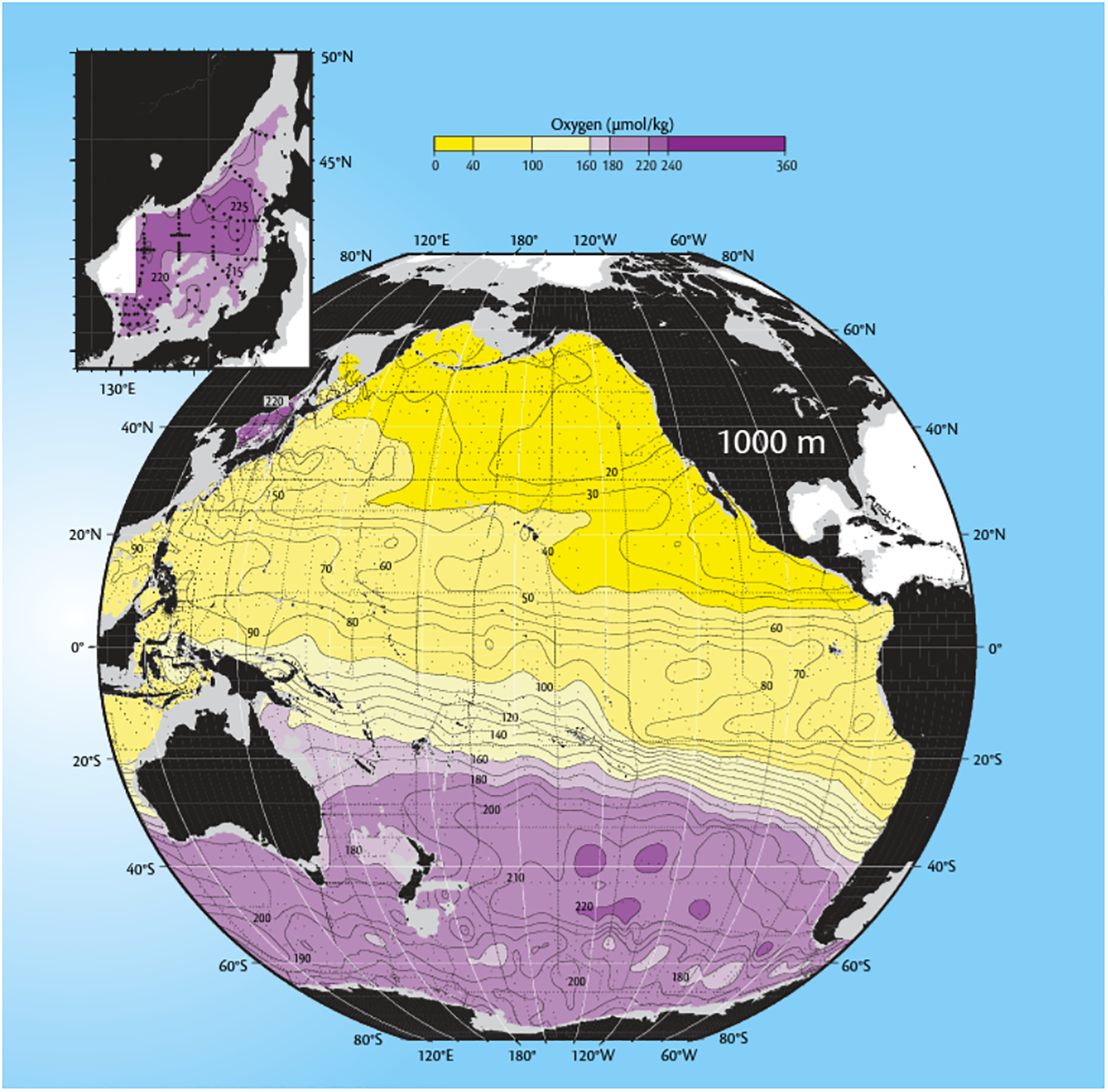
Figure 2. Long description
A heat map of the Pacific Ocean showing oxygen density at 1,000 meters depth. The map uses a color scale ranging from purple to yellow, indicating oxygen levels from high to low. The East Sea in the top-left corner is highlighted in purple, indicating high oxygen density, making it a major outlier. Most of the northern Pacific region is depicted in shades of yellow, indicating depleted oxygen levels. The map is overlaid on a globe with latitude and longitude markers, and an inset zooms in on the East Sea region. The data is presented in a grid layout with contour lines showing oxygen concentration levels in micromoles per kilogram.
How and where the ventilation happens in the East Sea is a topic that intrigues many physical oceanographers. We now know that oxygenated water is generated during the winter in waters near the Russian coast, as sea ice and cold winds cool down the surface water. The chilled seawater then descended to the bottom of the basin along the continental slope to renew the abyssal East Sea.Footnote 22 The exact mechanism of the vertical convection and abyssal circulation, however, remained a mystery before the CREAMS research in the 1990s. In order to understand the mechanism, it was essential to examine the waters of the northern East Sea, where the deep convection takes place. Yet, strict military security around the Soviet Union’s Pacific Navy at Vladivostok prohibited scientists from investigating this region.Footnote 23 The Iron Curtain worked not only as a geopolitical barrier but also as a hurdle for geoscience.
A synoptic survey of the East Sea was, in fact, practically impossible for most of the latter half of the twentieth century. Throughout the Russo-Japanese War, the Pacific War, and the Korean War, the East Sea had become one of the hot spots of global territorial conflicts.Footnote 24 During the Cold War, the sea was fragmented along the conflicting territorial claims by South Korea, North Korea, Japan, and Russia. The geopolitical division resulted in the fragmentation of oceanographic knowledge as well. In a 1984 study, for instance, Kuh Kim’s team identified an unusually cold body of water on the eastern coast of the Korean peninsula and named it East Sea Intermediate Water (ESIW). Kim suspected that the cold water originates from the northern East Sea and might be a key to understanding the oxygenation of deep water.Footnote 25 Yet, since their access to North Korean and Russian waters was strictly prohibited at the time, Kim’s team could not fully understand the oceanic process that governs the basin-wide circulation. A paper led by Kyung-Ryul Kim, another important CREAMS member at Seoul National University, stated in 1991 that ‘revealing the origin of the East Sea Intermediate Water is one of the top priorities of research … when it is possible to conduct the oceanic survey of the northern East Sea through scientific cooperation with North Korea or Russia’.Footnote 26
Even when comprehensive surveys were conducted, the data were not disclosed publicly. Soviet scientists, for instance, conducted various oceanic measurements on the East Sea to assist the operation of the Russian Navy fleet at Vladivostok. These data were mostly classified as military secrets. In 1956, for instance, the FERHRI published an important collection on East Sea oceanography. However, this monograph is ‘considered confidential even today and not generally available to the wider oceanographic community’.Footnote 27 The difficulty of international cooperation was exaggerated due to the language differences among East Asian nations. ‘Because papers in Japanese, Russian and Korean are very difficult to understand by anybody other than native Japanese, Russian and Korean authors, it is possible that the results of these investigations must await translation before they are used more widely in other countries.’Footnote 28 The secrecy and language barrier aggravated the already fragmented study on the troubled waters.Footnote 29
Due to these multilayered hurdles, the scientific understanding of the East Sea before the CREAMS expedition remained more or less similar to that of the early twentieth century. Interestingly, even in the 1990s, East Asian ocean scientists considered data from the 1930s as a valuable reference to the East Sea oceanography. The geopolitical situation in East Asia in the 1930s was in many ways different from that of the 1990s. After its victory against Russia in 1905, Imperial Japan quickly consolidated its maritime control over the East Asian marginal seas. Japan’s territorial power spanned from Taiwan to the Korean peninsula and northern islands. With uninterrupted geopolitical control over the East Asian waters, the Japanese empire was in a unique territorial position to conduct a synoptic survey of the current system.Footnote 30
Japan had strong economic motivations to study the East Sea as well. In the 1930s, the East Sea was one of the world’s largest fishing grounds for pelagic fish, such as sardines.Footnote 31 Sardines were processed into canned food, but they were much more valuable as a source of fish oil and fertilizer. At the height of the Pacific War, fish oil was even chemically treated to replace the shortage of petroleum.Footnote 32 However, the wartime usage of sardines was often troubled as their catch fluctuated due to changing oceanic conditions. The Japanese Imperial Fishery Experimental Station was commissioned to conduct a comprehensive oceanographic survey of currents and plankton, the primary food for fish.Footnote 33 This form of ocean science, like other state-driven earth sciences at the time, was part of Japan’s geopolitical campaign of making nature more legible and predictable, thereby transforming it into a territory that could be appropriated.Footnote 34
In the 1930s, Michitaka Uda, a young physicist enlisted at the experimental station, conducted large-scale surveys of the East Sea and its adjacent waters.Footnote 35 Uda’s multi-ship cruise is impressive even by contemporary standards. It involved three research vessels and fifty fishing boats from Japan, Korea, and Taiwan to survey the East Sea and its connected systems.Footnote 36 More than 10,000 current bottles were deployed to reveal the surface current of the East Sea. Uda’s survey produced fundamental data and theories frequently cited throughout the twentieth century. Relatively less acknowledged than this monumental scientific achievement, however, were the geopolitical conditions that made such large-scale surveys possible. The cruises were both enabled and motivated by the imperial desire to territorialize and economize the East Asian maritime space.
The fall of Imperial Japan brought an end to the territorial gaze that saw the East Sea as a connected whole. As the basin was separately occupied by four nations with unfriendly relationships—South Korea, North Korea, Russia, and Japan—the oceanographic research of this region remained dormant for decades. Although there were attempts for international oceanic studies in the later part of the twentieth century, these projects were often collections of national research programmes rather than transnational cooperations. In the 1960s and 1970s, for instance, UNESCO initiated a major international project to study the East Asian seas titled Cooperative Study of the Kuroshio and adjacent regions (CSK).Footnote 37 The study, however, focused on enhancing the national ocean science capabilities of East Asian nations, rather than producing a general understanding of the current system. A new wave of geoscience required a new geopolitical condition that would once again allow the border-crossing study of the fragmented sea.
CREAMS: Charting the shattered East Asian sea (1993–96)
That novel form of cooperation in East Asian oceanography began to appear in the final decade of the twentieth century. What signalled an essential change in both geopolitics and geoscience was the collapse of the Soviet Union. With the end of the Cold War, the East Asian nations began to establish official diplomatic ties with the Russian Federation. Compared with the 1980s, when interaction with communist societies was strictly prohibited, the changed geopolitical situation generated a more amiable mood for scientific cooperation. South Korea, for instance, established its diplomatic relations with Russia in 1990. The same year, the official shipping routes between Busan and Vladivostok were established. The shifting geopolitical atmosphere allowed scientists to move across national borders much more easily.Footnote 38
The dissolution of the Soviet Union brought abrupt economic changes to the Russian research community that led them to participate in international research. Oceanic research institutes at Vladivostok once owned and operated one of the largest research fleets in the world to support its Pacific Navy. Yet, along with the fall of the Soviet Union, funding from the government plummeted in the 1990s. The maritime scientists and technicians at FERHRI and Pacific Oceanological Institute (POI) had to either leave the institutes or get a second job to make their day-to-day living. Two Russian participants of the CREAMS later recalled that they ‘worked at the institute in the morning and built a Canadian motel on Okeanskaya in the evening’ to maintain their lives as professional scientists.Footnote 39 Faced with such extreme economic difficulty, Russian experts began considering foreign research institutes as their new financial source. By leasing their research vessel to Korean and Japanese scientists, they sought to acquire the budget to maintain their office. The change in financial sources shifted the academic agenda of Russian scientists as well. Before the Soviet collapse, most Russian ocean scientists at Vladivostok preferred to conduct research on the Pacific Ocean, which often resulted in larger financial returns than the studies on the marginal sea. However, the changing economic situation led them to follow the academic interests of Korean and Japanese scientists and to study smaller basins like the East Sea.Footnote 40 For Korean and Japanese scientists, on the other hand, the participation of Russian institutes provided a brief economic opportunity to lease their research vessels at a lower cost.Footnote 41 The fluctuating economic conditions after the Soviet dissolution generated new motivations and opportunities for border-crossing ocean science.
The third circumstance was the unexpected environmental consequences of the Soviet dissolution. In 1993, a white book published by the Russian government revealed that the Russian Navy at Vladivostok had been dumping radioactive waste into the East Sea and Okhotsk Sea since the 1960s.Footnote 42 The disclosed documents caused intense public anxiety about maritime safety in South Korea and Japan. The dumping continued even after the problem was made public. In October 1993, the Russian Navy, with no financial means to contain the accumulating materials from retired nuclear submarines, dumped 900 tons of liquid radioactive waste into the East Sea.Footnote 43 The dumping greatly disturbed the Korean and Japanese governments, who worried that deep ocean currents might spread the radioactive material into their territorial waters. In 1994, the three countries formed a joint research team to examine the impact of dumping. The joint team concluded that ‘there was no clear evidence of an increase in radionuclide concentrations due to the dumping of radioactive wastes by the former Soviet Union and Russian Federation’.Footnote 44 While the public fear of nuclear waste quickly faded, the incident provided a major motivation for East Asian nations to closely monitor the marine environment of the northern East Sea. The changing geopolitical situation, combined with economic interest and environmental concerns, made the East Sea an increasingly important site for international scientific research.Footnote 45
Within the shifting political circumstances, the collaborative study in the East Sea was also made possible by the advancement of technologies for ocean science research that happened around the late 1980s. In the field of physical oceanography, the improvement of temperature, salinity, and dissolved oxygen sensors allowed scientists to make much more precise measurements aboard research vessels. High-accuracy data was particularly useful to CREAMS scientists, since the temperature and salinity gradient within the East Sea basin was far less dramatic than larger basins like the Pacific Ocean.Footnote 46 The development of remote measurement technologies like satellites, drifters, and deep-sea moorings provided further information to measure currents in less accessible parts of the East Sea.Footnote 47 The popularization of oceanic simulation models in the late 1980s also made the East Sea basin an appropriate object for numerical study.Footnote 48 The advancements in science and technology provided material means to the East Asian scientists as they planned to utilize the changing diplomatic situations as their window of opportunity.
As the academic interest in the East Sea accumulated, ocean scientists with similar motives began to gather at international workshops. PAMS/JECSS (Pacific Asian Marginal Seas/Japan East China Sea System), a biannual international ocean science workshop convened by Japanese oceanographer Takashi Ichiye, was a particularly important stage of social networking for East Sea oceanographers.Footnote 49 Throughout the 1980s, PAMS/JECSS became an important meeting ground for scientists interested in the marginal sea. The fifth workshop, held at Kangnung, South Korea in 1989, was particularly successful.Footnote 50 South Korean local organizers led by Kuh Kim invited scientists from various East Asian nations, including the Philippines, Taiwan, and Japan. The Kangnung workshop, most importantly, was the first time the scientists from the Soviet Union participated in the meeting. That year, Kangnung became an important venue for the multinational group to build social networks and share their common scientific interest in the East Asian marginal seas.Footnote 51
Who were the scientists that participated in the PAMS/JECSS meeting? It is interesting to note that the scientists who gathered to study the marginal sea were themselves somewhat peripheral to the mainstream academic society in their respective fields. Masaki Takematsu and his team at the Research Institute of Applied Mechanics (RIAM) at Kyushu University were well known for their fluid-mechanics approach to the ocean. However, they were hardly mainstream researchers within the Japanese ocean science community, which was primarily led by Tokyo-based oceanographers and fisheries scholars.Footnote 52 Jong-Hwan Yoon, another CREAMS member at Kyushu University, was a Korean scientist in Japan who wished to utilize transnational ocean science as a means to reconcile the troubled history between Korea and Japan.Footnote 53 Fluent in Korean, Japanese, and English, he played a crucial role as a transnational communicator. Kuk Kim was a respected faculty member at Seoul National University in South Korea, yet he was struggling to lead his poorly funded department. In order to cope with a relatively small budget and the absence of a research vessel, international cooperation was a means for his team to participate in cutting-edge science.Footnote 54 The peripheral status of each scientist was a factor that nudged the CREAMS members to form a highly original and somewhat eccentric multinational group. The members acknowledged their unusual characteristics and would jokingly call themselves ‘Crazy and Ridiculous East Asian Marine Scientists’, which is also abbreviated into CREAMS.Footnote 55 Marginality, personal backgrounds, and economic situations drew these scientists together besides their common scientific interests.Footnote 56
With personal ties established through international workshops, the momentum for the CREAMS study started in Japan. Takematsu won a grant from the Ministry of Education, Culture, Sports, Science, and Technology for his proposal on the East Sea study. As a simulation expert, he believed that the East Sea is an ideal subject for the model study because of its moderate size. His idea was to develop a complete numerical model of the East Sea that includes the deep current in the Russian sector. In order to develop this model, he would need to take direct measurements of the deep-sea current, especially in Russian waters. For this, he would need to collaborate with a physical oceanographer who could design and lead the cruise. Kuh Kim, a physical oceanographer he knew from the PAMS/JECSS workshop, was an ideal collaborator for Takematsu. A graduate of the Woods Hole Oceanographic Institution (WHOI), Kuh Kim had solid experience in fieldwork. Plus, his position at a Korean university would be highly beneficial in acquiring clearance to access Korean waters. Takematsu asked Kim to visit his institute in Fukuoka, Japan, to discuss a plan for collaborative study. Kuh Kim, at the time fascinated by the dynamic water structure of the East Sea, responded with enthusiasm. He drafted a cruise route for their study over a night at his hotel in Fukuoka.Footnote 57
In making the border-crossing cruise possible, the most critical part was getting access to the northern part of the East Sea. The waters off the coast of Vladivostok were a scientifically important target, where the scientists suspected that the initiation of the deep convection was taking place. Thus, the investigation of the northern East Sea would be vital to understanding how the deep-water formation is being impacted by changing climate conditions. Takematsu and Kim contacted Yuri Volkov, the director of FERHRI, who they also knew from the previous PAMS/JECSS meeting. Volkov, at the time, was striving to maintain the research institute and welcomed their proposal for international research. In 1992, Kuh Kim and Jong-Hwan Yoon visited Vladivostok to discuss their work and plan the international cruise.Footnote 58 The budget and more specific plans for the cruise were consolidated when Takematsu visited Vladivostok in July 1993 to sign the agreement with FERHRI.Footnote 59
Throughout the planning phase of CREAMS, the most crucial decision scientists made was to use a Russian research vessel rather than a Japanese one. Under the Russian flag, the international team believed, the CREAMS cruise would be ‘released from the spell of EEZ’ and ‘run around almost freely in the basin’.Footnote 60 The use of a Russian vessel was also economically beneficial to FERHRI. By leasing their rusting ship to the international team, Volkov aimed to assist his institute financially. In July 1993, RIAM and FERHRI signed an agreement on the cost of the CREAMS cruise. The contract dictated that FERHRI would be responsible for preparing the research vessel Professor Khromov and ‘provide authorities approval for measurements in Russian economical zone’. In return, Kyushu University would provide ‘2000 US$/day for operating the research vessel assigned for this cruise’. In total, Takematsu agreed to provide 42,000 USD to the Russian research institute.Footnote 61
The decision to use R/V Professor Khromov, however, created an unexpected problem in the Japanese part of the East Sea. Initially, the team planned to port to Hakata, Fukuoka, to ship the necessary laboratory equipment from Kyushu University. However, the Japanese government, at the time irritated by the nuclear dumping incident by Russia, did not allow Takematsu’s proposal for the entry of R/V Professor Khromov into its territorial waters. The CREAMS team had to find an alternative way to load the equipment from Japan. They decided to use the port of Busan, where Kuh Kim succeeded in getting the approval of the port authorities for the Russian ship. However, transporting laboratory gear from Japan to Korea required a significant budget. National geopolitics became a direct financial burden for international science.Footnote 62
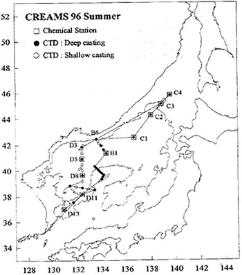
In 1996, the CREAMS team faced more profound challenges as the Japanese government declared and enforced its exclusive economic zone (EEZ). The newly enforced international treaty on the law of the sea at the time stipulated that states can designate an EEZ up to 200 nautical miles from their coasts. Within the EEZ, states are guaranteed legal rights to permit or decline hydrographic surveys. Japan’s declaration of its EEZ in 1996 significantly restricted the area that R/V Professor Khromov could cover. In the 1996 study, the international team departed from Busan with the hope that, by the time the ship arrived near the Japanese EEZ, the Japanese government would issue them the clearance needed for the Russian ship to survey the Japanese part of the sea. Despite these anticipations, the Japanese government did not allow the research of R/V Professor Khromov within its EEZ, possibly due to the ongoing dispute with Russia regarding the nuclear waste dumping. The Russian government, upon receiving the news, responded by also banning the survey by the international team for the remaining part of the CREAMS cruise. In order to secure the data points in the north-eastern part of the East Sea without the clearance from both nations, the scientists came up with a brilliant idea: they decided to sample along the EEZ boundaries between the two countries (Figure 3). This clever tactic of navigating through the complex geopolitical tension allowed East Asian scientists to study the conflicted sea despite their limited geographical access.Footnote 63
Cruise route of CREAMS research in 1996. Note that the south-east part of the East Sea was not surveyed due to the Japanese EEZ declaration that prohibited the access of the Russian ship. Kuh Kim et al., Tonghaeŭi haesu mit mulchilsunhwane kwanhan yŏn’gu (Kwahakkisulch’ŏ, 1997), 42.

Figure 3. Long description
A map depicting the cruise route of the CREAMS research in the summer of 1996. The map highlights various locations marked with different symbols: squares for chemical stations, filled circles for deep CTD castings, and open circles for shallow CTD castings. The route covers a significant portion of the East Sea, with notable exclusions in the southeast due to the Japanese exclusive economic zone (EEZ) declaration. Key locations are labeled with identifiers such as C1, C2, C3, C4, B1, B6, D1, D3, D5, D8, and D13.
The challenges of border-crossing oceanography in the East Sea suggest how territorial concerns have critically shaped the course of maritime investigations, especially for scientists with less geoscientific and geopolitical resources. Historians of science have explored how access and transportation to the field site can structure the geographical scope of research practices in geosciences.Footnote 64 Yet, as these studies primarily examine projects by major Western nations with relatively large authorities to create and access their field sites, they do not emphasize the difficulties faced by less influential actors like East Asian scientists. By highlighting the practical challenges of border-crossing science, the case of CREAMS expedition reminds us that scientific access to the field site is never given but rather gained through material and political tactics.
Geopolitical conflict, however, was not always an obstacle for the border-crossing science. The volatile geopolitics of the 1990s could work to the scientists’ advantage if they could appropriate them by aligning their research with national interests. This was particularly true for the South Korean researchers, who framed the CREAMS as a scientific endeavour to protect the nation’s maritime territory from Russian nuclear waste. In a 1997 report to the Ministry of Science and Technology, the Korean CREAMS members suggested that their international cooperation is a strategic study to generate ‘essential data for predicting the movement and diffusion of Russian nuclear waste’.Footnote 65 The international cruise was necessary to ‘gauge the influence of the nuclear waste dumping on the marine environment and ecosystem of the East Sea’.Footnote 66 In a media interview, Kuh Kim similarly suggested that scientific research on the circulation of the East Sea is imperative to understand the possible impact of the underwater nuclear waste dumped by Russia.Footnote 67 By framing CREAMS as a project for territorial security rather than basic science, Korean scientists could elicit financial support from their government in the late 1990s. The complicated geopolitics of the time allowed Korean scientists to appropriate territorial tensions by aligning their research with national motives for geoscience.
The emphasis on the CREAMS cruise as a means for promoting national interests, however, is hardly found in international representations of the research. Instead, the CREAMS scientists strived to frame their research as more of an apolitical study on global climate change that would intrigue the international scientific community. In their report to Geophysical Research Letters, most notably, the CREAMS team highlighted their finding that the highly oxygenated deep water of the East Sea had been slowly disappearing over the past decades.Footnote 68 While there was not enough evidence to ascertain the exact cause of such changes, the authors argued that the decreasing oxygen level ‘could be a result of recent global warming manifested on a regional scale’.Footnote 69 The CREAMS members further detached the East Sea from its local context by emphasizing its similarities with larger oceans. In the Geophysical Research Letters article, the team argued that these recent changes in the East Sea show a ‘remarkable resemblance to the changes predicted in the Atlantic Ocean in association with the global warming’.Footnote 70 Given these similarities, they argued that the East Sea is not just a marginal basin but ‘a very appropriate natural laboratory for studying future global changes’.Footnote 71
The rhetoric of the East Sea as a ‘natural laboratory’ effectively elevated the regional study on a marginal basin to a global study of the changing ocean in a warming world. At the same time, such framing obscured the local geopolitical factors that significantly shaped, challenged, and financed the research. Rather than emphasizing the cruise’s implications to the nuclear waste incident, for instance, the CREAMS team focused on politically neutral and internationally valued implications of their scientific findings. The use of the term ‘natural laboratory’, in this sense, was a strategic choice made by the scientists to avoid the thorny diplomatic problems of the sea and cleverly appropriated the rising international interest in climate change.
The framing of the East Sea as a miniature ocean resonates with the literature that analysed the power relations embedded in the rhetoric of natural laboratories. Studies on biological research stations have argued that the image of natural laboratories is often employed to justify the exclusive use of nature by international scientists while restricting the access of the indigenous people. In other words, knowledge of the global environment is constructed at the expense of localized ways of knowing and utilizing nature.Footnote 72 The case of CREAMS research similarly suggests that the emphasis on global science often erases local contexts that characterize the sea. Yet, the laboratorization of the East Sea differs from these previous cases in that the rhetoric was actively sought by the East Asian scientists themselves. The framing of the East Sea as a natural laboratory was adopted as a strategy for the local scientists to avoid geopolitical controversy, access the disputed part of the sea, and join international scientific communities. The case study on CREAMS, therefore, broadens the study of natural laboratories by suggesting that rhetorical tactics are not only the means for exploitation but also a strategy for marginalized scientists to appropriate dominant narratives and overcome asymmetrical power relations.
Hahnaro expedition: US scientists on a Russian boat (1999–2001)
The unique cooperation and findings by CREAMS scientists gained significant attention from the other side of the Pacific rim. In June 1996, most notably, Stephen Riser at the University of Washington and Steve Ramp at the US Office of Naval Research (ONR) co-hosted an international workshop on East Sea science in Honolulu, Hawaii. Eighteen scientists from South Korea, Japan, and Russia were invited to participate in this three-day workshop and present their findings from recent international cruises. The discussion primarily revolved around appreciating the achievements of CREAMS and discussing what must be further explored about the East Sea. The community concluded that future studies must focus on understanding the detailed mechanism for deep circulation and its relation to the high oxygen concentration at the bottom of the East Sea basin. The meeting became an important venue for US scientists to be connected with the CREAMS team, leading to an additional multinational cruise from 1999 to 2000.Footnote 73
The interest from the US ocean science community can be understood within a larger trend in physical oceanography throughout the 1990s. The prime research objective of that era was to develop an accurate numerical model of the ocean and to estimate its change over time. Major observation programmes like the World Ocean Circulation Experiment (WOCE, 1988–2002) were organized to generate high-quality oceanic measurements at a global scale. These data were then utilized to develop planetary models that estimate the impact of atmospheric climate change on global heat transfer via oceanic circulations.Footnote 74 With a circulation regime similar to that of the Atlantic Ocean, the East Sea was considered a scaled model of the global ocean. Since it is much smaller in size, it was regarded as an ideal test bed to conduct experimental multidisciplinary studies at an affordable cost. Within this context, CREAMS ‘made it very attractive, and feasible, for a group of US scientists to join in the study of this fascinating miniature ocean’, which would serve as ‘the very model of modern major oceanography’.Footnote 75
Nevertheless, these scientific rationales alone do not sufficiently explain the sudden interest in this basin. The Hawaii workshop and the cruise study that followed were sponsored by the US ONR, the leading funding source of oceanographic research. ONR’s interest in the marginal sea must be understood within the context of 1990s maritime geopolitics. By the end of the 1980s, it was becoming clear that most maritime conflicts occurred not in the open ocean but in the coastal region and marginal seas. A prime example was the Gulf War, in which a major battleground turned out to be the Arabian Sea. This trend accelerated with the collapse of the Soviet Union, when ‘the primary domain of naval ocean research shifted abruptly from deep to coastal oceans’.Footnote 76 By the end of the 1990s, ONR was funding several studies to survey the East Asian marginal sea. The Asian Seas International Acoustics Experiment (ASIAEX, 1999–2001), for instance, aimed to understand the acoustic characteristics of the East China Seas.Footnote 77 Closely related to this was the Dynamical Linkage of the Asian Marginal Seas (LINKS, 1999–2001) project sponsored by the Naval Research Laboratory (NRL) that aimed to verify the connections between the marginal seas of the Pacific Ocean.Footnote 78 ONR’s funding of the East Sea oceanography was a part of the broader changes in the US funding scheme that recognized the Pacific rim, rather than the open sea, as an increasingly important zone of potential conflict.
In 1997, ONR called for proposals to lead its direct research initiative on the oceanographic survey of the East Sea. Seventeen experts from major oceanographic research institutes in the United States were selected to lead the programme.Footnote 79 The hydrography survey, which was the most significant component of the whole initiative, was led by Lynne Talley at the Scripps Institute of Oceanography (SIO). As an active participant of WOCE, Talley’s aim in this study was to bring the full-scale research programme designed for large ocean studies to the East Sea basin. With closer CTD (conductivity, temperature, and depth) stations, her cruise was expected to provide a high-resolution snapshot of the sea and analyse the vertical structure of the basin in greater detail.Footnote 80 These highly accurate field measurements would be combined with new techniques like satellite sensing and simulation models to reveal the changing structure of the East Sea in unprecedented detail.
As CREAMS researchers did, a crucial task for the principal investigators of the ONR programme was acquiring the clearance to travel across the complicated borders of the East Sea. The clearance procedure was particularly important, given that the funding was coming from the US Navy. Obtaining the clearance was especially important for Talley, whose objective was to conduct a synoptic survey of the whole East Sea as the CREAMS scientists did. The main research vessel for the ONR programme was R/V Roger Revelle, a US research vessel of the Scripps Institute of Oceanography. Learning from the previous East Sea studies, Talley anticipated that it was ‘unlikely that a single country’s vessel will be able to complete all of the stations’.Footnote 81 Therefore, from the beginning, she planned to use two ships for the study by collaborating with Russian researchers. According to the original plan, the team would first survey the southern part of the East Sea with R/V Roger Revelle after acquiring permission from South Korea and Japan. Then, the international team would harbour at Otaru, Japan, and transfer all the equipment to the R/V Professor Khromov. The team would then use the Russian ship to survey the upper half of the East Sea to gain complete data on the basin.Footnote 82
The concerns US scientists had about potential international conflict are well illustrated in a short anecdote on the naming of the mission. As the chief scientist of the main cruise, Talley wanted the code name of her survey to well represent the cooperative characteristics of the study. More practically, she wanted to avoid the name that might offend East Asian governments and hamper international cooperation. Talley contacted Dongha Min, a recent Scripps alumni and a South Korean post-doctoral researcher at the University of Washington.Footnote 83 She asked Min to recommend Korean words suitable for the expedition’s name. Min recommended some Korean words that convey the ideal of peaceful and friendly international cooperation: Woojung (Korean for friendship), Saijohke (Korean for getting along), and Woorimodu (Korean for all together). Among various candidates, Talley chose Hahnaro, which means to one (unity) in Korean. Hahnaro, Talley noted, had ‘nice meaning’, ‘seems easy to pronounce’ for non-Korean speakers, and ‘doesn’t have any meaning in English’.Footnote 84 In addition, it was noted that the abbreviation (HNRO) seemed ‘inoffensive’ to the multilingual science team.Footnote 85 The consideration over the choice of the code name reveals the wide range of concerns scientists had to consider in getting international approval for the expedition.
An amiable name alone, however, was insufficient to resolve the complicated EEZ issue at the East Sea. A few months before the cruise, Talley was notified by Yuri Volkov at FERHRI that ‘in recent years the Russian government has banned work by foreign research vessels in the Russian JES sector north of 41 15’N.’Footnote 86 Moreover, ‘Russian research vessels with non-Russian scientists aboard are treated for clearance purposes as if they are foreign vessels.’Footnote 87 This implied that ‘it is not possible for the Khromov to work in this area with non-Russians aboard.’Footnote 88 Due to the enhanced restrictions by the Russian government, the second half of the survey on the northern East Sea, unlike the original plan by Talley, would have to be conducted solely by Russian members, without any help from the United States, South Korean, and Japanese scientists.
The sudden change in the clearance issue generated concerns over the operation of scientific instruments. Talley’s cruise involved full-scale data collection, including shipboard measurement of CTD, salinity, oxygen, and nutrients. Due to the various measurements, the cruise would require about six technical staff for data collection. In the original plan, the data acquisition was to be done by three US technicians from SIO, assisted by three additional Russian technicians. However, as the US technicians could not accompany the second half of the cruise on R/V Professor Khromov, the team had to recruit additional Russian staff to cover the shortage of personnel. Talley, in her supplementary proposal to ONR, asked the support for ‘2 additional Russian chemists from POI beyond those who were already funded in the original award’.Footnote 89
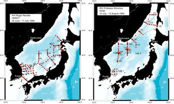
There were further concerns about the uniformity of the data in the second half of the expedition. All of the measurements were planned to be obtained through the Oceanographic Data Facility (ODF), the standard measurement facility of SIO. While the Russian technicians and chemists were highly trained experts, they were unfamiliar with some of the US standards and protocols. If the second half of the cruise was done without the US operators, there existed a risk of Russian technicians obtaining unreliable data. In order to make sure that R/V Professor Khromov could obtain quality measurements without US operators, Talley also made a quick change to the cruise plan. She decided to include a ‘test cruise’ between the first and second parts of the cruise. After transferring all measurement equipment from R/V Roger Revelle to R/V Professor Khromov, the team would spend three extra days together to verify that the US instruments on the Russian ship were working correctly. The test cruise would also be a chance to make sure that the Russian crew is capable of making high-quality data without US operators. Since there were ‘major difficulties with obtaining Japanese clearance for the Russian ship’, the test cruise could not take place near Otaru, where Talley originally planned to transfer.Footnote 90 In response, Talley decided to change the transferring port from Otaru, Japan, to Busan, South Korea. This way, the team would be able to conduct the test cruise within the South Korean EEZ, where they found it much easier to gain clearance for both research vessels (Figure 4).
The revised cruise route for Talley’s Hahnaro expedition. Note that the expedition was conducted in two parts with two different ships. Also note that the cruise of R/V Professor Khromov consists of two legs. Leg 1 is the three-day test cruise conducted within the South Korean EEZ. Personal archive of Lynne Talley.
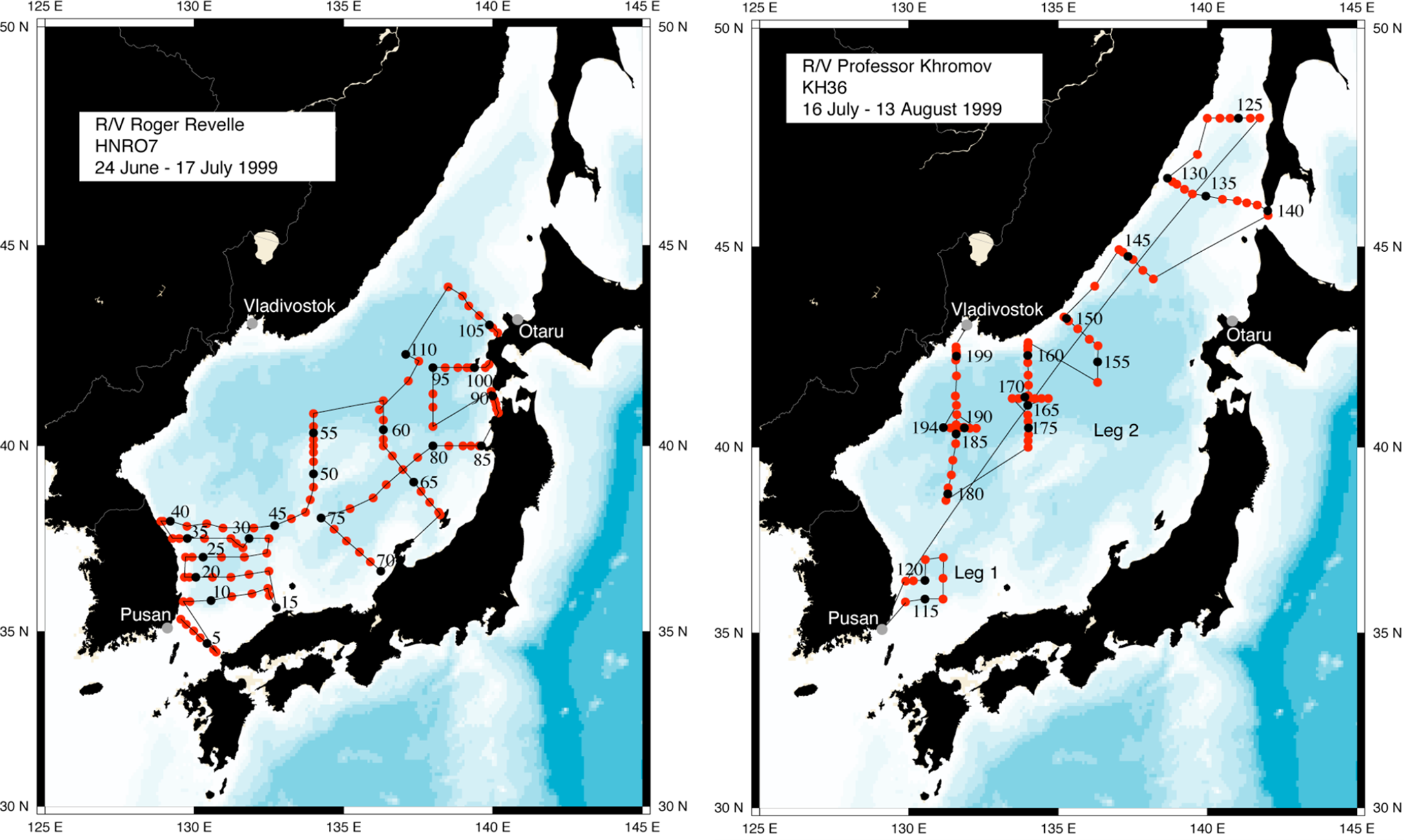
Figure 4. Long description
Two maps show the revised cruise routes for Talley’s Hahnaro expedition. The left map depicts the route of R/V Roger Revelle from June 24 to July 17, 1999, starting from Pusan, South Korea, and ending in Otaru, Japan. The right map shows the route of R/V Professor Khromov from July 16 to August 13, 1999, which includes two legs. Leg 1 is a three-day test cruise conducted within the South Korean EEZ, and Leg 2 continues from Vladivostok to Otaru. Both maps highlight key locations such as Pusan, Vladivostok, and Otaru, and display the paths taken by the ships with marked stations and coordinates.
Talley had to make a couple of budgetary adjustments in accordance with the changed plan. First, more funds were needed to support two more Russian scientists who were required to be on board during the first part of the cruise. Second, due to the introduction of the test cruise and the change of transfer location, the cruising period for R/V Professor Khromov was increased by approximately four days. Longer ship time meant the US team had to pay extra lease fees to the Russian collaborators. Talley’s task as the principal investigator was to explain this change of circumstances to the ONR and acquire permits for further expenses.Footnote 91
The problems with clearance continued to occur throughout the actual cruise. Even when the team had all the necessary documents required to certify their clearance, they were still followed by coastguards who closely watched the scientists with suspicious eyes. The frequent security checks by the maritime authorities were an unusual experience for Talley because, in her previous expeditions at the high seas, encounters with other ships, let alone the security vessels, only rarely happened. In personal correspondence, Talley noted that ‘encounters with the Korean marine patrol and Navy were a little less welcome given our clearance status’.Footnote 92 Similarly, in the Japanese part of the East Sea, ‘the daily P3 flyover checking our reported position reminds us that our presence is noted’.Footnote 93 A deeper problem occurred when Talley’s team tried to survey the waters close to a South Korean island. When the R/V Roger Revelle approached the island, South Korean security police stopped them from surveying the Korean territorial waters. The team attempted to persuade the police by showing that they had all the mandatory clearance documents from the relevant offices. Nevertheless, the guards were adamant about securing the waters. The team had no choice but to leave the island and abandon a few data points.Footnote 94 The geopolitical tension surrounding the island left an unexpected blank in the geoscientific data.
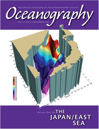
Despite such difficulties of border-crossing science, the findings of the Hahnaro expedition were widely celebrated as a major success of international collaboration. In 2006, most notably, a special issue on the Hahnaro expedition appeared in the journal Oceanography.Footnote 95 What decorated the cover page was Talley’s report on the ventilation regime of the East Sea (Figure 5). By analysing the CTD measurement in waters near Vladivostok, Talley’s team provided a more refined explanation of deep-water formation called ‘brine rejection’. Talley suggested that cold air in the northern East Sea causes sea ice formation, which leaves salty water at the surface. This dense water mass then descends to the bottom of the basin along the continental slope to provide oxygen to the deep ocean.Footnote 96 While the discovery of this mechanism was praised as an important finding to explain the impact of climate change on marginal seas, less was acknowledged about the local geopolitical hurdles Talley had to overcome in order to produce this geoscientific knowledge.
The cover page of the special issue on the Hahnaro expedition in the journal Oceanography. Oceanography 19, no. 3 (2006), the special issue on the Japan/East Sea, accessed 6 May 2026, https://tos.org/oceanography/issue/volume-19-issue-03.

Figure 5. Long description
The cover of the Oceanography journal, volume 19, issue 3, dated September 2006, showcases a 3D graphic representation of the Japan/East Sea. The graphic includes a color-coded depth map with various shades indicating different depths, ranging from shallow to deep areas. The color scale on the left side of the graphic helps interpret the depth variations. The background is predominantly purple, and the journal’s title, ‘Oceanography,’ is prominently displayed at the top in white text. Below the graphic, the text ‘Special Issue on the Japan/East Sea’ is written in white.
The globalization of East Sea oceanography reached a pinnacle in 2007 when the fourth assessment report of the Intergovernmental Panel on Climate Change (IPCC) mentioned studies by the CREAMS international team as evidence of global warming. The report included a short section on the impact of global climate change on the Pacific marginal seas and cited CREAMS publications as references. The report itself did not directly use the term ‘miniature ocean’. Yet, it reproduced the CREAM scientists’ narrative that ‘the Japan (or East) Sea is nearly completely isolated from the adjacent ocean basin’ and ‘because of this sea’s limited size, it responds quickly through its entire depth to surface forcing changes’.Footnote 97 While the report utilized the East Sea as an important case study to prove oceanic changes at a global scale, it had no room to describe the geopolitical concerns that funded and motivated the survey on this highly conflicted basin.
The cover of the special issues and the description of the IPCC report share a particular spatial imaginary of the East Sea as a basin that transcends its locality. Rather than a collection of fragmented national territories, it was imagined as an international space free of geopolitical interests. Instead of a basin full of conflicting national interests, it was portrayed as a miniature ocean in which scientists forecast the planet’s future and test out new technologies in marine science. These explanations deterritorialized the East Sea from its concrete geopolitical relationships. In other words, the imaginary of internationalism shadowed the geopolitical concerns that affected the design and execution of the Hahnaro expedition.
Conclusion
The ideal of internationalism was short-lived, as the rising nationalism and lingering post-colonial relations threatened oceanographic cooperation in East Asia. In the early 2000s, geopolitical tension rather than transnational cooperation characterized ocean science projects in this region. In 2004, for instance, the South Korean government attempted to put a Korean name on the submarine geographical features in the East Sea by submitting proposals to the International Hydrographical Organization (IHO). The submission was a part of the nation’s move to reaffirm its territorial sovereignty in the basin. The Japanese government, angered by the South Korean attempt, reacted by sending hydrographic survey ships to the South Korean territorial waters.Footnote 98 The tension escalated as South Korea dispatched coastguard ships to prohibit the survey ships from approaching the region. The conflict reached a hiatus as both countries agreed to halt their scientific endeavours. The hostile atmosphere caused by these incidents, however, made border-crossing science far more difficult than before. In later years, ocean science in East Asia became a means to assert national territorial claims rather than a mode of international cooperation.Footnote 99
More recently, the oceanic current in East Asia once again emerged as a matter of geopolitical concern as the Japanese government decided to discharge radioactive waste water from the Fukushima nuclear power plants into the Pacific Ocean. Rather than using oceanography as a means to coordinate an international response to the environmental risk, East Asian nations employed marine science more as a national strategy to monitor the possible radioactive incursion via connected waters. In South Korea, for instance, government-funded research institutes developed autonomous boats that patrol along the maritime borders to sample the travelling seawater and surveil the potential inflow of radioactive materials.Footnote 100 As oceanic science is increasingly recognized as a strategic resource for territorial security, it has become significantly difficult for transnational scientists to imagine the East Sea as a place for international cooperation.
Considering the difficulties of international cooperation after the 2000s, it seems that the 1990s was arguably a special period in the history of East Asian marine science. How did it become possible for East Asian scientists to produce knowledge about the troubled waters in the final decade of the twentieth century? From a macroscopic point of view, we can clearly see that global geopolitical shifts like the collapse of the Soviet Union provided a window of opportunity for East Asian scientists in their attempts for border-crossing surveys. Amiable political atmospheres, shifting economic interests, and the environmental crises triggered by the Soviet dissolution provided new motives and means for scientists to study the waters beyond their national borders. The rare success of transboundary science in the territorially conflicted basin well illustrates how the geopolitical context of the post–Cold War period allowed oceanographers to imagine new scientific agendas beyond their national borders. Conversely, it attests to the wide-ranging impact of Cold War tensions in limiting the transnational communication of potentially strategic information such as ocean science data.
Despite relatively favourable geopolitical circumstances, however, the border-crossing science was still challenged by lingering colonial relations and emerging international conflicts in maritime space. The case study of CREAMS also tells us that the construction of new knowledge required scientists to develop material, political, and rhetorical tactics to circumvent or appropriate these remaining challenges. In order to bypass the competing EEZ claims of Japan and Russia, scientists came up with clever material designs for their cruise. Scientists also developed political strategies to gain financial support from national governments. While South Korean scientists elicited government funding by reframing their cruise as research to protect the national environment from Russian radioactive waste, the US scientists also followed ONR’s interest in maritime security in the Western Pacific. By highlighting these tactics as hidden factors for border-crossing cooperation, this study suggests that global histories of environmental science must better examine how the strategic choices made by individual actors may play a crucial role in the making of transboundary knowledge.
The study on the East Sea was also made possible through the rhetorical tactics that geoscientists employed to describe their research as a politically neutral endeavour. The CREAMS scientists and the US scientists alike were interested in describing the East Sea as a ‘natural laboratory’ or ‘miniature ocean’, a smaller body of water used to estimate the changes in global oceans. Indeed, the physical similarities between the East Sea and the larger oceans are intriguing coincidences that call for scientific investigation. Yet, the real power of the terms ‘natural laboratory’ and ‘miniature ocean’ is found when we consider the geopolitical usefulness of these rhetorical devices. By framing the East Sea in this way, CREAMS scientists could connect their work with international scientific discourse on climate change while distancing it from sensitive geopolitical problems such as Soviet nuclear dumping. In other words, the metaphors helped scientists to deterritorialize the East Sea by replacing its unique political and economic relations with global implications. Pointing out the strategic use of scientific metaphors, this study asks us to critically examine how scientists choose and develop rhetorical devices to enable scientific work amid geopolitical tension.Footnote 101
The case study of CREAMS contributes to global maritime history scholarship by decentring the narrative of transnational maritime politics from large oceans and instead highlighting the significance of marginal basins like the East Sea. Traditional narratives of oceanic history have primarily focused on voyages, cruises, and politics on large basins like the Pacific, Atlantic, and Indian Oceans.Footnote 102 Yet marginal seas like the East Sea, East China Sea, and South China Sea can offer more intriguing cases of maritime diplomacy since these waters are closer to the land and therefore more severely challenged by competing territorial claims and maritime conflicts.Footnote 103 The story of CREAMS offers a fresh insight into how a small basin like the East Sea can be considered a central site for diplomatic negotiations as well as an unexpected place for developing scientific discourse on global environmental change.
The time of writing marks the thirtieth anniversary of the first CREAMS cruise. In July 2024, oceanographers at Seoul National University organized a workshop to celebrate the legacy of the CREAMS expedition.Footnote 104 Japanese and Russian scientists who spent time together aboard R/V Professor Khromov visited Seoul to share their memories of East Sea oceanography. Oceanographers who participated in the research as young graduate students have now become senior scientists who worry about the difficulty of international cooperation in the East Sea. At the meeting, scientists expressed their mutual interest in another international study and shared future plans for border-crossing research. For now, we do not know whether these proposals will bring a new wave of transboundary collaboration. What we know for sure is that the politics of maritime territories will continue to structure how we study and frame troubled waters. Changing geopolitical tides, furthermore, will require scientists to develop new strategies as they aim to chart the shattered sea.
Acknowledgements
The author thanks the members of KAIST STP and the Max Planck Institute for the History of Science for their valuable comments on the earlier version of this article.
Financial support
This work was supported by the National Research Foundation of Korea (NRF) grant funded by the Korean government (MSIT) (NRF-2018R1A5A7025409) and a research fellowship from the International Commission of the History of Oceanography (ICHO).
Competing interests
The author declares none.
Sungeun Kim is an assistant professor in the Division of International Studies at Korea University. Before joining Korea University, he was a visiting post-doctoral fellow at the Max Planck Institute for the History of Science. His research focuses on the history of earth sciences, science diplomacy, and environmental politics in East Asia.


 Open access

