


Introduction
South-eastern Europe is one of the first areas of the Continent with a complete, documented set of Near-Eastern Neolithic innovations, which includes pottery manufacture, architectural techniques, settlement patterns and exogenous domesticated plants and animals. As far as we know, its communities were largely dependent on grain crops produced by intensive garden cultivation (Bogaard & Halsted Reference Bogaard, Halstead, Fowler, Harding and Hofmann2015; Halsted & Isaakidou Reference Halstead, Isaakidou, Gron, Sorensen and Rowley-Conwy2020), and the earliest settlements were located in areas with optimal climatic conditions for growing and harvesting cereals (Krauß et al. Reference Krauß, Marinova, de Brue and Weninger2018). Research over the last decades has also demonstrated that communities migrating from the Near East introduced not only domesticated species and technologies, but also symbolic behaviours and beliefs, enmeshed in a complex known as the Neolithic package (Çilingiroğlu Reference Çilingiroğlu2005; Perlès Reference Perlès and Lichter2005). Within this set of ideas and practices, farming is undoubtedly a major element, combining the reality and ideology of subsistence economy, with a stronger symbolic value given to domesticated resources than to those from the natural or wild environment (Hodder Reference Hodder1990; Perlès Reference Perlès2001).
Such an emphasis on agricultural activities characterised the Near Eastern and Southern European Neolithic, while further west, several transformations in the package involved the omission or addition of other elements (Manen & Perrin Reference Manen, Perrin and Collectif2009). This included the symbolic and aesthetic spheres, in which aspects of the wild environment played a major role, especially in connection with big-game hunting, but also regarding the occupation of natural spaces, such as caves (Whitehouse Reference Whitehouse1991; Grifoni Cremonesi Reference Grifoni Cremonesi1994; López-Montalvo Reference López-Montalvo2018).
The study of farming practices in Early Neolithic south-eastern Europe (6700–5800 cal BC) has so far focused predominantly on Greece and Bulgaria; other areas, such as Albania and North Macedonia, require more thorough multidisciplinary research (Valamoti & Kotsakis Reference Valamoti, Kotsakis, Colledge and Conolly2007; Allen & Gjipali Reference Allen, Gjipali, Përzhita, Gjipali, Hoxha and Muka2014; Kreuz & Marinova Reference Kreuz and Marinova2017). Given its location between the southern (maritime) and northern (terrestrial) routes of Neolithic expansion, North Macedonia is a particularly crucial area for understanding the spread of agriculture towards both the Mediterranean and Central Europe (Garašanin Reference Garašanin and Benac1979; Sanev Reference Sanev and Stardelov1995; Bunguri Reference Bunguri2014; Reingruber Reference Reingruber, Sarris, Kalogiropoulou, Kalayci and Karimali2017; Krauß et al. Reference Krauß, Marinova, de Brue and Weninger2018). In the regions of Ovče Pole and the Skopje Valley, and Polog, Pelagonia and Lake Ohrid, the Neolithic began at the end of the seventh millennium BC, when a number of agricultural societies gradually emerged (Gimbutas Reference Gimbutas1976; Naumov et al. Reference Naumov, Fidanoski, Tolevski and Ivkovska2009). In the Early Neolithic, these groups formed small regional clusters, as indicated by pottery styles (Naumov Reference Naumov2015). From the Middle Neolithic (starting 5800 cal BC) and continuing into the Late Neolithic (from 5200 cal BC), these communities were incorporated within larger cultural groups that were closely associated with their neighbouring territories (Garašanin Reference Garašanin and Benac1979; Sanev Reference Sanev and Stardelov1995; Fidanoski Reference Fidanoski2019). A diversity of settlement patterns is apparent, from villages located on flat river terraces, to tell sites in wetland valleys and pile-dwelling sites on lake edges. Such settlements consist predominantly of wattle-and-daub buildings that feature a variety of clay installations for storage and food preparation, such as ovens, bins and granaries (Stojanova Kanzurova Reference Stojanova Kanzurova2008; Naumov et al. Reference Naumov, Fidanoski, Tolevski and Ivkovska2009).
In this article, we present new evidence for the initial phases of the Neolithic in North Macedonia derived from recent research carried out at two sites: Govrlevo and Vrbjanska Čuka. We combine data from archaeobotany and the use-wear analysis of stone tools in order to reconstruct crop harvesting techniques and crop husbandry methods; both were essential aspects of Neolithic life that can inform about technological traditions, seasonal activities and settlement dynamics. In addition, our evidence for farming practices is set within the context of the visual expressions and ritual behaviours of the North Macedonian Neolithic.
The Neolithic sites of Vrbjanska Čuka and Govrlevo
Vrbjanska Čuka
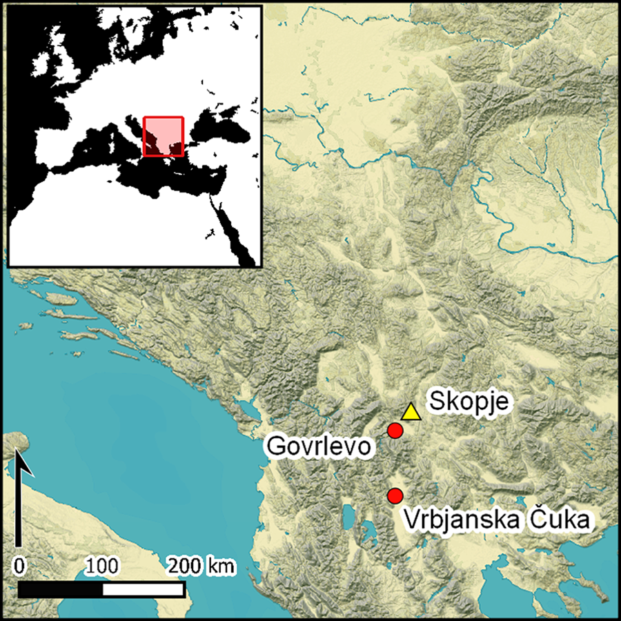
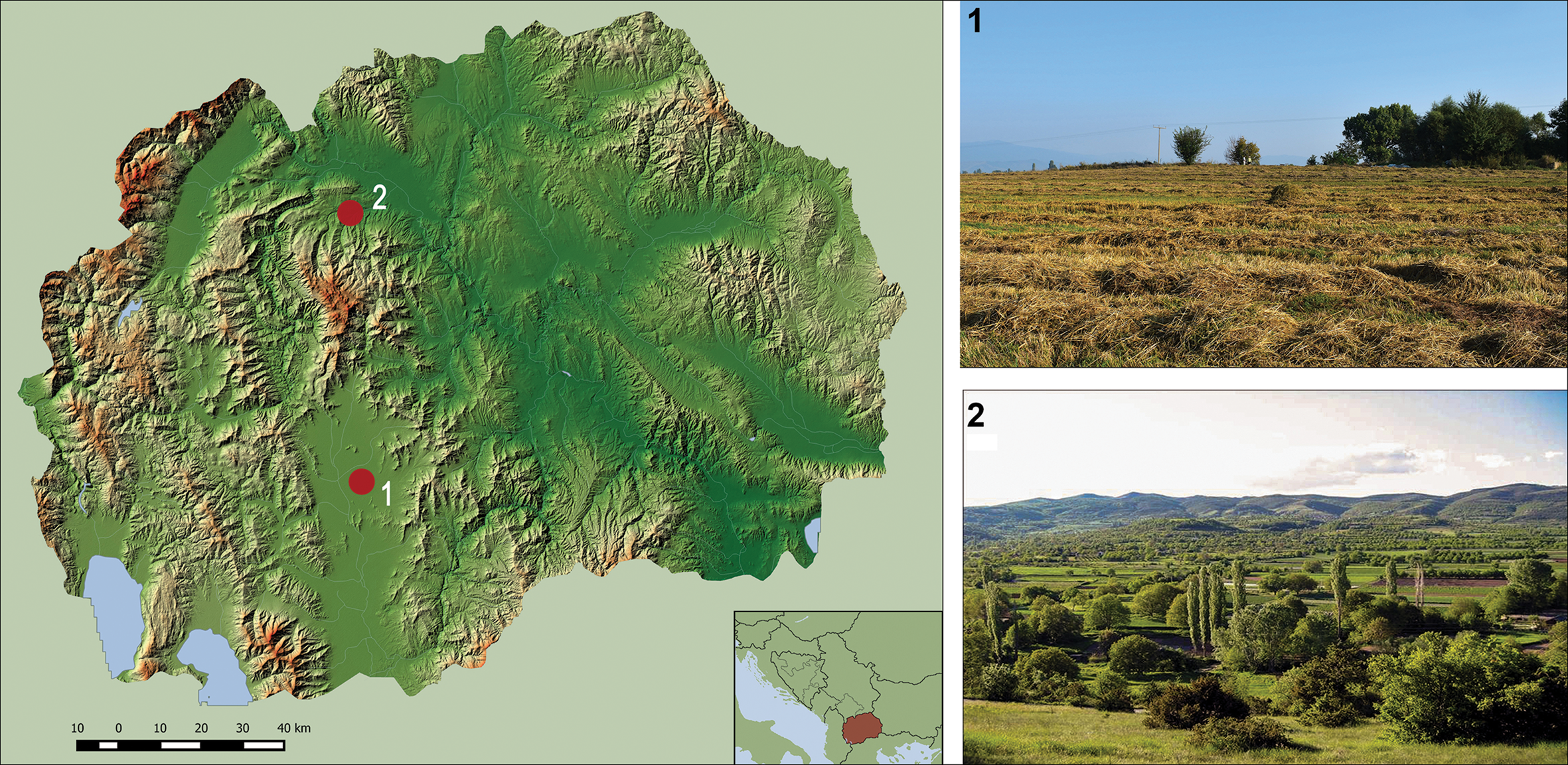
Vrbjanska Čuka is a tell in the northern part of Pelagonia, an elongated valley in the south-west of North Macedonia (Kitanoski Reference Kitanoski1989; Mitkoski Reference Mitkoski2005) (Figure 1: 1). Radiocarbon dates indicate that the settlement was established c. 6000 cal BC and abandoned c. 5700 cal BC (Naumov et al. Reference Naumov2021). This Neolithic village consisted of wattle-and-daub buildings and was enclosed by a ditch with an entrance in the south-east of the tell (Naumov et al. Reference Naumov, Mitkoski, Talevski, Fidanoski and Naumov2018a). Several types of buildings have been excavated, including massive structures with burnt wattle-and-daub walls, clay installations for storing and processing cereals (i.e. granaries, bins, ovens and circular grinding areas), buildings made of unburnt wattle-and-daub, and a few others with deep foundation trenches for their walls (Figure 2). The inhabitants of Vrbjanska Čuka consumed a diversity of aquatic and domesticated terrestrial resources (Naumov et al. Reference Naumov2018b).
Map of North Macedonia (left) with the location and views of Vrbjanska Čuka (1) and Govrlevo (2) (map by G. Milevski and G. Naumov; photographs by G. Naumov & B. Kavur).
Clay granary in Vrbjanska Čuka (modified from Naumov et al. Reference Naumov2018b: 281, fig. 15).

Govrlevo
The site of Govrlevo is located at an altitude of 500m asl on a flattened terrace on the southern slope of the Vodno Mountain, on the southern border of the Skopje Plain (Figure 1: 2). The site was excavated in the 1980s and the early 2000s (Bilbija Reference Bilbija1985; Fidanoski Reference Fidanoski2015). It was occupied in the Early and Middle Neolithic (c. 6000–5500 cal BC). Settlement continuity at Govrlevo is demonstrated by the houses, which were built one above the other by successive generations of inhabitants. Although the material culture of Govrlevo is attributed to the main Neolithic culture group in Macedonia, the Amzabegovo-Vršnik, it exhibits clear similarities with the Pelagonian Velušina-Porodin Culture, which is also found in Macedonia (Fidanoski Reference Fidanoski2012). No archaeobotanical studies have been undertaken at this site.
Materials and methods
Stone tool analysis
We analysed 211 stone tools from Vrbjanska Čuka and Govrlevo, representing all the relevant material stored at the Museum of Prilep and at the Museum of the City of Skopje. A preliminary classification of the raw materials was conducted by macroscopic examination of the main petrographic characteristics. All items were subjected to macroscopic (magnifications between 5× and 40×, using a DNT5MP digital microscope) and microscopic (magnifications between 50× and 400×, using an Olympus BH2 reflected-light microscope) observation. A more detailed analysis of the use-wear traces was carried out on those tools used specifically for cereal harvesting.
Archaeobotanical analysis
Archaeobotanical samples were obtained during the 2019 excavation campaign at Vrbjanska Čuka. The wash-over method was used (Kenward et al. Reference Kenward, Hall and Jones1980) to retrieve the plant macroremains. The plant taxa in the resulting fractions were identified by the morphological traits and surface patterns of the seeds, fruits and other plant parts, under a Leica S6E binocular microscope at up to 40× magnification. Thirteen samples have so far been analysed, comprising almost 2500 macroremains (Antolín et al. Reference Antolín, Sabanov, Naumov and Soteras2020). Five of the 13 samples, which contain abundant crop and weed remains, and which are believed to represent a residue of a single type of activity (e.g. cooking, crop processing, combustion) (van der Veen & Jones Reference van der Veen and Jones2006) were used to provide data for this research (see Table S1 in the online supplementary material (OSM)). To investigate the origin of these samples, the micro-residue approach was applied (Ullah et al. Reference Ullah, Duffy and Banning2015). This includes sorting and quantification of all observable elements (e.g. bone, shell, chaff, grain, charcoal, daub, pottery) in the light and heavy fractions, and comparing the data with information on the archaeological contexts. While the samples come from different buildings and horizons at Vrbjanska Čuka, the results are discussed at the site level until further data that may facilitate a more nuanced approach become available.
Results
Lithic assemblage
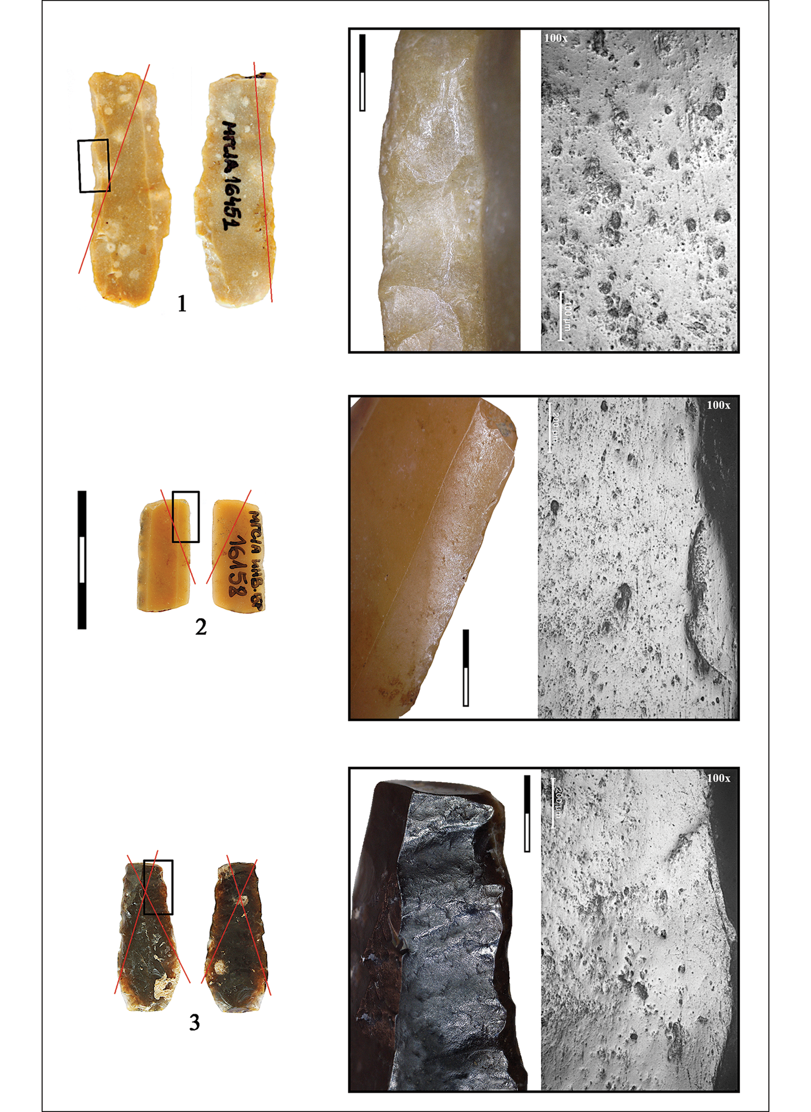
More than half (53 per cent) of the lithic assemblage from Govrlevo is made on a dark, black-grey chert, often with reddish tones (Figure 3: 1–3). Other types include a fine-grained, white-beige chert characterised by calcareous inclusions (15.9 per cent), a honey-coloured, fine-grained chert with massive texture (3.7 per cent), and a chocolate-coloured, fine-grained radiolaritic jasper (0.6 per cent) (Figure 3: 4–8) (Table S2). A blade-oriented production using direct percussion was probably carried out on site, while pressure-flaked blades on honey and white-beige cherts were produced off-site and obtained through exchange as flaked blanks, as their reduction sequence is not represented on site (Perlès Reference Perlès1992). Despite the smaller number of specimens from Vrbjanska Čuka, the same variety of cherts was noted, and numerous imported pressure-flaked blades were also documented.
Flaked stone assemblage from Govrlevo and Vrbjanska Čuka: 1–3) dark, coarse-grained chert; 4–8) exogenous chert types; 9) scatter plot with sickle insert measurements; 10) sickle inserts from Govrlevo; 11) sickle inserts from Vrbjanska Čuka (scales in cm) (photographs by N. Mazzucco).

We analysed 164 specimens from Govrlevo, identifying 52 glossy blades (Table S2). Most (n = 42) exhibit only one active edge, while 10 were used on both long edges, giving a total of 62 blade edges, to be set in sickles used for cereal harvesting (see below). Most were made on dark chert (n = 25), although fine-grained cherts and jasper were also used (n = 15). Except for two flakes, blades predominate: these are approximately 20–45mm long, 10–20mm wide and 4–5mm thick (Figure 3: 10 & Figure 4). We envisage that the blades fitted into sickles comprising a slightly curved handle of wood or bone, with several flint blades or flakes inserted at an angle into a slit along its inner curve (Figure 5)—similar to the antler sickles recovered from the Neolithic tell site of Karanovo in Bulgaria (Gurova & Bonsall Reference Gurova and Bonsall2014).
Blades from Govrlevo used for cereal harvesting (scales in cm) (photographs by N. Mazzucco).
Reconstruction of the type of sickle used at Govrlevo and Vrbjanska Čuka. The shape of the handle is based on the complete sickles from Karanovo (Bulgaria) (photographs and drawing by N. Mazzucco).
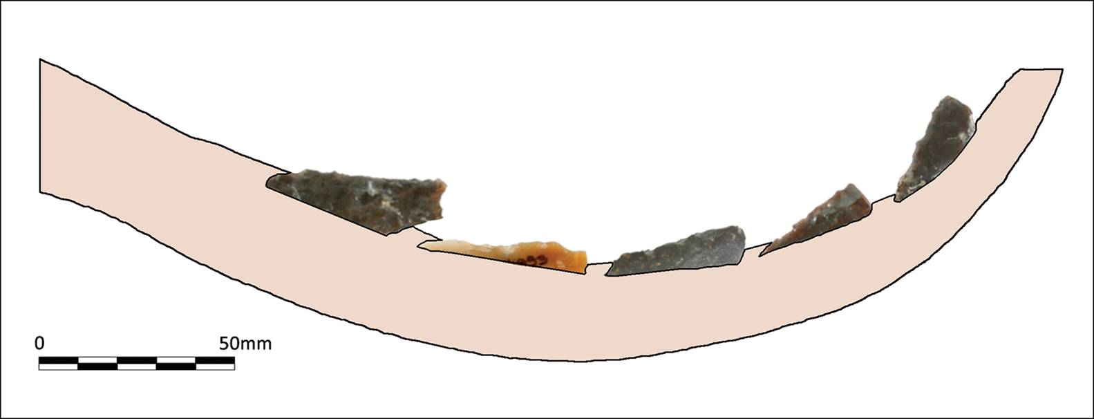
Of the 47 analysed specimens from Vrbjanska Čuka, 18 show a gloss on their edges produced by cutting cereal stalks (Table S2). Of these, 14 specimens have a single working edge, three tools exhibit two active edges, and one tool has up to three used edges, giving 23 used edges in total. Blade blanks predominate (n = 15) in the analysed assemblage, while only three flakes were used to make harvesting inserts. Tools were made on at least four varieties of fine-grained (n = 7) and coarse-grained (n = 6) chert. The average dimensions of the harvesting inserts are 30–40mm in length, 15–20mm in width and 4–5mm in thickness—similar to the Govrlevo blades (Figure 3: 11 & Figure 6).
Blades from Vrbjanska Čuka used for cereal harvesting (scales in cm) (photographs by N. Mazzucco).

All the analysed sickle inserts exhibit a gloss orientated diagonally. At a microscopic scale, use-wear traces are visible as a pitted and striated polish, as would be produced by cereal harvesting. Variations in the quantity of striations and abrasions on the lithic surfaces, however, suggest variability in the harvesting motion or the height at which the plants were cut. Glosses are well developed, entirely covering the inserts’ used edges up to the dorsal ridge. Ongoing experiments within the framework of the authors’ projects demonstrate that a marginal gloss is visible after ten hours of harvesting, confirming previous observations by other researchers (e.g. van Gijn Reference van Gijn1989: 40). For the Vrbjanska Čuka inserts, the extent of the gloss suggests prolonged use of the inserts over dozens of hours. Additionally, 14 (77.8 per cent) inserts at Vrbjanska Čuka and 22 (45.8 per cent) at Govrlevo were resharpened by retouch to prolong their effectiveness.
Archaeobotanical analysis
The five archaeobotanical samples selected from Vrbjanska Čuka yielded a considerable quantity of charred crop remains (predominantly chaff from einkorn (Triticum monococcum) and emmer (Triticum dicoccum)), but also a notable amount of potential weed remains; the latter comprise a total of 24 taxa, with almost 1000 remains classified (Table 1). Analysis of the seasonality of the potential weeds reveals a predominance of perennial plants. Out of 19 taxa with specified seasonality, three belong to summer annuals and three to winter annuals. Summer annuals account for 91 per cent of the potential weed remains, but, if Chenopodium album (white goosefoot or fat hen, which may have been intentionally gathered) is excluded, they comprise 15 per cent, and the winter annuals approximately 5 per cent.
Ecological characteristics of potential weed species and number of remains at Vrbjanska Čuka (data after Ellenberg (Reference Ellenberg1992) and Kreuz & Schäfer (Reference Kreuz and Schäfer2011)).
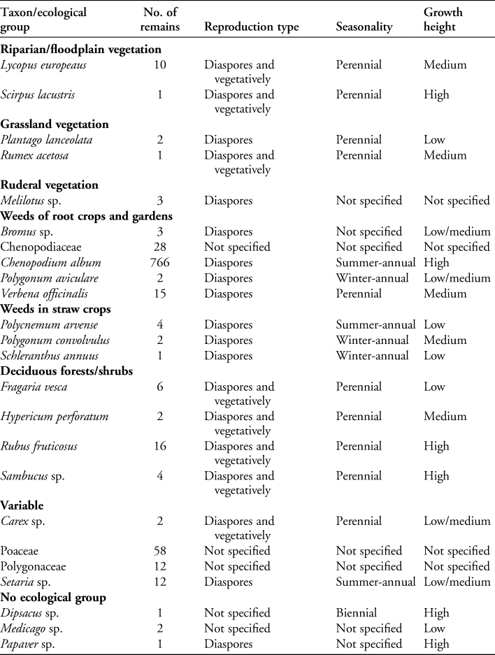
Plant species which reproduce vegetatively (i.e. asexually through propagation) thrive when they are broken apart and when there is greater disturbance of the soil, unlike competitive reproducers, which spread by diaspores and prefer conditions with low disturbance (Kreuz et al. Reference Kreuz, Marinova, Schäfer and Wiethold2005; Allen Reference Allen, Gori and Ivanova2017). The potential weed species from Vrbjanska Čuka are predominantly spread by diaspores, suggesting that cultivation may not have been intensive. As noted above, perennial species are also found in the analysed samples. These plants would usually be destroyed by severe disturbance caused by mouldboard ploughing, but can survive gentler tillage, for example with an ard (Jones Reference Jones1992).
Following Kreuz and Schäfer (Reference Kreuz and Schäfer2011), we classified weeds as tall (>0.8m), medium (0.5–0.8m) or low (<0.5m). Indeed, the height of the weed plants encountered in archaeobotanical assemblages is usually associated with differences in harvesting methods. When seeds that belong only to tall weeds are found, they suggest ear-harvesting, while the presence of low-growing weeds correlates with cutting the plants lower down, on the culm, by using a sickle (Kreuz et al. Reference Kreuz, Marinova, Schäfer and Wiethold2005). Most of the potential weed remains from Vrbjanska Čuka belong to high-growing species (92 per cent) but, given that nine out of 20 taxa with specific heights are low-growing, we can still assume that harvesting methods at the site involved cutting the stem low.
Discussion
From c. 6000 cal BC, the full Neolithic package began to spread north from the Aegean along the Vardar River Valley (Krauß et al. Reference Krauß, Marinova, de Brue and Weninger2018). Until now, little was known about the economy of the Neolithic Amzabegovo-Vršnik and Velušina-Porodin cultural groups in Macedonia. Beyond simply identifying crop species, archaeobotanical and use-wear analysis can provide new insights into the earliest farming practices, and illuminate aspects of plant husbandry, such as sowing time, cultivation intensity and harvesting techniques.
Data from Vrbjanska Čuka (Antolín et al. Reference Antolín, Sabanov, Naumov and Soteras2020) indicate that the most abundant crop species are cereals and legumes. Among the cereals, einkorn predominates, but there are also abundant finds of emmer and several of barley (Hordeum vulgare), which is represented by naked and hulled forms. Pea (Pisum sativum) is the best-represented of the pulses. This assemblage is similar to those of other contemporaneous sites in south-eastern Europe (Ivanova et al. Reference Ivanova, de Cupere, Ethier and Marinova2018).
Our archaeobotanical analysis of the Vrbjanska Čuka material strongly suggests that the Early Neolithic communities there could have practised spring sowing, although autumn sowing cannot be ruled out (Kreuz & Schäfer Reference Kreuz and Schäfer2011; Allen Reference Allen, Gori and Ivanova2017). The occurrence of riparian species (Lycopus europeaus (gypsywort) and Scirpus lacustris (common club-rush)) in the archaeobotanical assemblage may indicate the presence of local wetland environments; the spring sowing of crops would be in accordance with this, as sowing in such environments often takes place once the spring floods have receded (van Andel & Runnels Reference van Andel and Runnels1995). The presence of competitive reproducers and perennials among the taxa may suggest that the fields, or at least parts of them, were not intensively cultivated. Some of these taxa have edible fruits (e.g. Fragaria vesca (wild strawberry), Rubus fruticosus (European blackberry), Sambucus sp. (elder)), or have useful properties as insect repellents (e.g. Verbena officinalis (common verbena)), and thus may have even been encouraged to grow in nearby plots (Antolín & Schäfer Reference Antolín and Schäfer2020).
Given the abundance of Chenopodium album seeds at Vrbjanska Čuka and their occasional interpretation as a food plant at Early Neolithic sites (Mueller-Bieniek et al. Reference Mueller-Bieniek, Pyzel and Kapcia2020), it is probable that it was not merely considered a weed but was encouraged to grow and was collected intentionally. Therefore, it seems rational to exclude Chenopodium from our calculations. If we exclude it from the dataset, taxa with a low height comprise 40 per cent of the recovered archaeobotanical remains. As noted above, low-growing weeds correlate with cutting the plants lower down the stem, which may suggest a focus on gathering long straw that could have been used either as fodder (in turn, suggesting that domesticated animals were housed, at least temporarily, close to the settlement) or as raw material (e.g. for thatching or basketry) (Peña-Chocarro et al. Reference Peña-chocarro, Peña Zapata, González Urquijo, Ibáñez Estévez, Fairnbairn and Weiss2009; Hajnalová & Dreslerová Reference Hajnalová and Dreslerová2010). A further benefit is that it allows more grain to be collected, since not all the stems reach the same height at the time of harvesting—a scenario particularly common for spring-sown crops. More broadly, our results agree with those previously obtained from Bulgaria and Central Europe (Kreuz et al. Reference Kreuz, Marinova, Schäfer and Wiethold2005).
The sickles used by the first farmers of North Macedonia are characterised by a coarsely serrated cutting edge. The inset blades exhibit glosses resulting from prolonged use and the diagonal orientation of these glosses stems from being hafted within a slightly curved handle. The inclination of the inserts varies from 5–10° (almost parallel to the handle) to more inclined inserts between 20 and 35°, as also observed in other areas, such as Greek Macedonia and Thessaly (Mazzucco et al. Reference Mazzucco2020). Moreover, the lithic production systems and the raw materials exploited in North Macedonia indicate a close connection with the Aegean world. Honey flint and chocolate jasper are typically seen in Thessalian and Greek Macedonian lithic assemblages (Dogiama Reference Dogiama, Sarris, Kalogiropoulou, Kalayci and Karimali2018). Honey flint, whose sources have been hypothetically located in north-western Greece (Perlès Reference Perlès2001), is associated with tool distribution networks that connected distant areas in the Aegean Basin. These tools were made on high-quality raw materials that were reduced by skilled artisans using pressure-flaking methods. The presence of these imported raw materials in the Skopje Valley and in Pelagonia is probably due to such local, regional and long-distance exchange networks, which were established to provide the raw material and blanks necessary for producing harvesting inserts. Moreover, such networks not only facilitated the transport of raw materials but may also have acted as channels for the diffusion of domesticated plants, techniques and tools (Ibáñez et al. Reference Ibáñez, González-Urquijo, Teira-Mayolini and Lazuén2018). All this evidence suggests a close relationship between North Macedonia and Aegean and Anatolian groups—a relationship also indicated by decorative motifs on stamps and pottery (Naumov Reference Naumov2008). This wide distribution of similar subsistence practices, and technical and aesthetic behaviours supports the hypothesis that the Neolithisation of the Balkans developed in close association with Anatolia as the process moved through Thessaly and into the Macedonian region.
Use-wear analysis also provides insights into harvesting height and intensity. As in Greece, Macedonian sickle inserts are characterised by well-developed glosses produced by prolonged use over dozens of hours of harvesting. The frequently observed resharpening of the cutting edge provides additional proof of the long lifespan of the tools. Retouching the blade edges prolongs their effectiveness, preventing them from becoming dull after only a day or two of use. At both Vrbjanska Čuka and Govrlevo, sickle inserts are so intensely retouched that the cutting edge is often stepped, having been completely removed by the retouching process. This could be linked to limitations in raw material procurement and production, as suggested by the small quantity of lithic remains at both sites; perhaps the Neolithic farmers were forced to overuse their tools.
Regarding harvesting height, the presence of several striations over the micropolish fits well with a low cutting height, as demonstrated by Anderson's (Reference Anderson and Anderson1992) experimental studies. Use patterns observed at Vrbjanska Čuka and Govrlevo strongly resemble the harvesting techniques employed in Neolithic Thessaly and Greek Macedonia. Here, sickle inserts are the main tool type within lithic assemblages, reaching percentages of up to 20–30 per cent, indicating that agriculture provided a major source of food. By contrast, in the Impresso-Cardial complex of the Central and Western Mediterranean, the proportion of sickle inserts is considerably smaller, suggesting that agriculture either did not have the same importance or that it was practised on a smaller scale (Mazzucco et al. Reference Mazzucco2018, Reference Mazzucco2020). Archaeobotanical analysis also suggests that changes took place in crop frequencies and diversity, harvesting methods and, probably, cultivation outputs (Ivanova et al. Reference Ivanova, de Cupere, Ethier and Marinova2018; Bouby et al. Reference Bouby2020; de Vareilles et al. Reference de Vareilles2020). This scenario supports the notion that a reformulation of the Neolithic package occurred, with expansion towards the Western Mediterranean, at scales differentially affecting settlement patterns, subsistence practices, material productions and symbolic and ritual behaviours (Manen & Perrin Reference Manen, Perrin and Collectif2009).
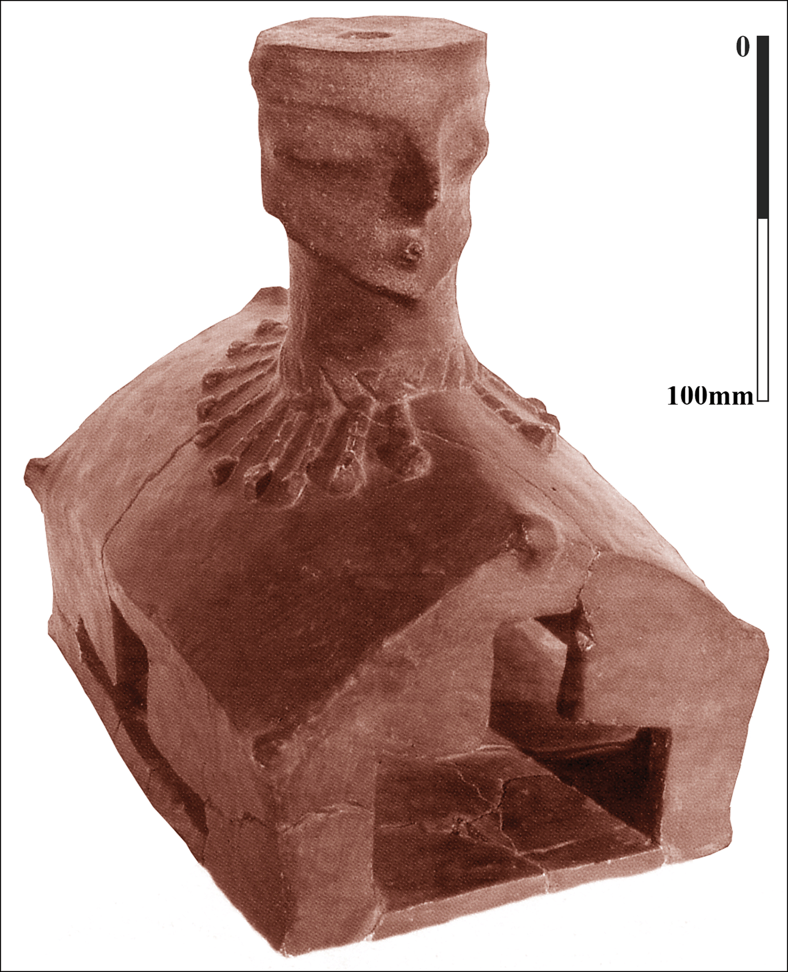
In addition to its initial economic and subsistence value, farming encompassed a broader spectrum of social practices and was also expressed symbolically, as attested at some Anatolian sites (Hodder 2010; Schmidt Reference Schmidt2010). In the Balkans, agriculture was introduced as part of a fully developed Neolithic economy, but it was not confined to the economic sphere. Agricultural practices are reflected in architecture, household organisation and in a diversity of items—a pattern that is particularly clear in the deeply stratified tell settlements located close to vast areas of fertile fields. Wattle-and-daub dwellings were continually rebuilt in processes apparently involving a series of ritual practices that attest to the importance of agriculture and the necessity of symbolic actions to protect the crops and ensure the success of future harvests (Naumov Reference Naumov, Blanco Gonzales and Kienlin2020). This is how we interpret the different sources of evidence from the Neolithic Balkans. Buildings, for example, were represented as anthropomorphic house models (Figure 7); granaries were decorated with symbolic patterns; grinding stones were turned upside down when dwellings were abandoned; and clay models of seeds and loaves were made (Mitkoski Reference Mitkoski2005; Naumov Reference Naumov, Malone and Barrowclough2007, Reference Naumov, Hoffman and Smyth2013; Chausidis Reference Chausidis, Gheorghiu and Cyphers2010). One such clay model of a bread loaf was discovered in a Neolithic house at Govrlevo, together with construction materials, grinding stones, cereals and ash (Čausidis & Naumov Reference Čausidis, Naumov and Fidanoski2019). In addition, stamp-figurines have been associated with the preparation of bread, as attested ethnographically by stamps used to mark loaves as part of specific rituals (Naumov Reference Naumov2008). In such a symbolically charged environment, agriculture was not merely an everyday activity, but a significant element of both the sacred and profane realms of the first farmers in the Balkans.
Anthropomorphic house model from Porodin (from Kolištrkoska Nasteva Reference Kolištrkoska Nasteva2005: fig. 43; reproduced with permission of the Museum of the Republic of North Macedonia).
Conclusions
Our overview of agricultural practices in the Macedonian Neolithic includes new data from the sites of Govrlevo and Vrbjanska Čuka in North Macedonia, which suggest that permanent crop fields were present within wetland areas, with autumn and spring sowing possibly practised. These crops were harvested at a low height using curved sickles. Harvesting was a major economic activity, and the frequent resharpening of the blades suggests that sickles were used intensively. Use-wear and archaeobotanical data have revealed, for the first time, Neolithic farming practices in this area of the Balkans, including crop choice, sowing time and harvesting techniques. Our study is offered as a contribution not only to our knowledge of early farmers in the Macedonian Neolithic, but also to our understanding of the spread of the Neolithic package across Europe.
Funding statement
This work forms part of the projects ‘La Difusión del Neolítico en el Mediterráneo Centro-Occidental (HAR2016-75201-P)’ and ‘Tools, Techniques and Specialists: the keys to understand the Mesolithic–Neolithic transition in Mediterranean Europe (Tool & Tech)' (PID2020-112513RB-I00), both funded by the Spanish Ministry of Science, Innovations and Universities, and a Marie Sklodowska Curie Individual Fellowship ‘QUANT (792544)’. The ‘AGER’ project was funded by the Italian Ministry for Education, Universities and Research within the ‘Rita Levi Montalcini’ programme. Amalia Sabanov's work was undertaken within the project ‘Bioarchaeology of Ancient Europe (III 47001)’, funded by the Ministry of Education, Science and Technological Development of the Republic of Serbia. The excavations at Vrbjanska Čuka and Govrlevo were funded by the Ministry of Culture of North Macedonia. We acknowledge support of the article processing charge by the CSIC Open Access Publication Support Initiative through its Unit of Information Resources for Research (URICI).
Supplementary material
To view supplementary material for this article, please visit https://doi.org/10.15184/aqy.2021.32


 Open access