

Emotions are a key force that shape past and present human societies. This has long been tacitly acknowledged by archaeologists, particularly in regard to monumental architecture and public rituals and the roles they played in bringing human populations together. More recently, emotions have become the focus of more overt analysis (Tarlow Reference Tarlow2000, Reference Tarlow2012), given the growing recognition in archaeology and related disciplines that emotions such as awe (Sanger Reference Sanger2024), loneliness (Santos Reference Santos2025), and anxiety (Fleisher and Norman Reference Fleisher and Norman2016) shaped human experiences in the past. It is important to acknowledge that emotions are socially constructed, but that does not mean that we, as archaeologists, should ignore them. Indeed, human practices, places, things, and traditions both reflect and shape human emotions. Moreover, material correlates of emotions are visible in the archaeological record and provide valuable insight when trying to reconstruct and understand the past.
Emotions, moreover, are a crucial factor to consider when looking at coalescent communities. Coalescent communities are new social formations created by multiple social or cultural groups that come together due to external pressures or stimuli (Birch Reference Birch2010, Reference Birch2012; Kowalewski Reference Kowalewski, Pluckhahn and Ethridge2006; Watts Malouchos and Betzenhauser Reference Watts Malouchos, Betzenhauser, Watts Malouchos and Betzenhauser2021). One external force that brings such communities together is emotion: fear, anxiety, religious fervor, awe, and other emotions can pull diverse groups into new configurations. Moreover, for coalescent communities to flourish, collective unifying emotions are key. Archaeologists seeking to understand coalescent communities should consider ways in which built environments, material remains, and traces of inhabitants’ activities help create the prevailing emotions in broader historical contexts and reflect and shape emotions within the community itself.
In this article we highlight the importance of emotions in understanding coalescent communities using the Noble-Wieting cultural site in modern-day central Illinois as an example (Figure 1). Drawing on multiple lines of archaeological evidence, we argue that Noble-Wieting was a coalescent community and that the broader affective fields that permeated the greater Midwest in the thirteenth century AD were crucial in its creation. Specifically, population movements, social unrest, and climate change and the complex emotions they invoked—for example, overarching atmospheres of uncertainty, insecurity, fear, and anxiety—drove cultural groups to form coalescent communities like Noble-Wieting. However, Noble-Wieting was unlike any other known coalescent community of its time—its people, architecture, objects, and more were assembled in such a way to generate emotions that contrasted with the broader affective fields in which Noble-Wieting was situated, which in turn shaped the identities and attitudes of its residents. We argue that emotions are key to understanding both the founding and nature of Noble-Wieting specifically and coalescent communities more broadly.
Location of Langford and Mississippian settlements in central Illinois.

Coalescent Communities, Emotions, and Affective Fields
Coalescent communities have received considerable attention in archaeological circles (Birch Reference Birch2010, Reference Birch2012; Birch and Williamson Reference Birch and Williamson2013; Hill et al. Reference Hill, Clark, Doelle and Lyons2004; Kowalewski Reference Kowalewski2003, Reference Kowalewski, Pluckhahn and Ethridge2006; O’Gorman and Conner Reference O’Gorman and Conner2023; Watts Malouchos Reference Watts Malouchos, Watts Malouchos and Betzenhauser2021). As new social formations, coalescent communities are by necessity diverse in composition; they may, for example, include local populations, relatives through marriage, immigrants, refugees, captives, ambassadors, or any combination of these (Kowalewski Reference Kowalewski, Pluckhahn and Ethridge2006). Of course, although many studies of coalescence note an increased focus on integrative institutions and practices, coalescence does not mean the abandonment of tradition, social homogeneity, or complete integration (Birch Reference Birch2012:666; Watts Malouchos Reference Watts Malouchos, Watts Malouchos and Betzenhauser2021:24–25). Many early studies of coalescent societies drew inspiration from late precontact and early colonial period Indigenous groups in North America because these groups experienced major cultural, social, political, and economic upheaval caused by colonization (Ethridge and Hudson Reference Ethridge, Hudson, Hill and Beaver1998, Reference Ethridge and Hudson2002). Most of these studies attempted to identify evidence of coalescent societies, reconstruct the circumstances in which coalescence occurred, or examine how people renegotiated their identities during and after coalescence. Few studies, however, considered the role of emotions in coalescent communities. This is problematic because emotions, as products of the intertangling of all kinds of phenomena, shape the contexts that lead to the creation of coalescent communities as well as the attitudes and practices of community members after coalescence.
The lack of focus on emotion, or “the act of being moved” (Harris and Sørensen Reference Harris and Sørensen2010:149; see also Fleisher and Norman Reference Fleisher and Norman2016; Gosden Reference Chris, DeMarrais, Gosden and Renfrew2004; Harris Reference Harris, Kienlin and Koch2017), in coalescent community scholarship is also surprising, especially because more recent studies have shifted focus from coalescent societies to coalescent communities (e.g., Birch Reference Birch2012; see review in Watts Malouchos Reference Watts Malouchos, Watts Malouchos and Betzenhauser2021). These studies treat communities as multilayered and ever-changing assemblages of people, things, materials, places, and landscapes that are “socially constructed at multiple scales through routine practices and lived experiences” (Watts Malouchos and Betzenhauser Reference Watts Malouchos, Betzenhauser, Watts Malouchos and Betzenhauser2021:147; see also Harris Reference Harris2014). This view highlights the diverse nature of communities “as variable, dynamic, multiscalar, and socially constructed rather than as natural, territorial, or universal entities” (Watts Malouchos Reference Watts Malouchos, Watts Malouchos and Betzenhauser2021:20).
Communities affect individual activities and do things that change history (Pauketat Reference Pauketat, Varien and Potter2008). They also create and are created by what some scholars call “affective fields.” Harris and Sørensen (Reference Harris and Sørensen2010:150) define affective fields as sets of relationships between all kinds of phenomena “where something or somebody is stimulating an emotional response in a causal set of events. . . . They are about the ways in which emotions are produced, triggered or provoked, changing the state of affairs in a given situation” (see also Harris Reference Harris2014). The term “atmosphere” is another way to think about affective fields, especially as they shape and are generated within communities. Atmospheres are groupings of affects—defined as the capability of any phenomena to affect and be affected by the world (Crellin and Harris Reference Crellin and Harris2021)—that emanate from relationships that assemble in specific locales and contexts (Harris and Sørensen Reference Harris and Sørensen2010; see also Anderson Reference Anderson2009; Sørensen Reference Sørensen2015; Stewart Reference Stewart2011). From this perspective, communities are created within and animated by a host of ever-changing affective qualities that come from the interconnections among people, entities, spaces, objects, materials, and more; the resulting atmospheres are what give communities a particular “feel,” “aura,” or “flavor” and instigate emotions in community members (see Anderson Reference Anderson2009).
Moreover, communities are a result of, or at least form in, larger regional assemblages, which have their own sets of affects and atmospheres. These larger regional assemblages are analogous to what some scholars have called social fields, relational fields, networks, or meshworks (e.g., Bourdieu Reference Bourdieu1977; Deleuze and Guattari Reference Deleuze and Guattari1987; Ingold Reference Ingold2000, Reference Ingold2007, Reference Ingold2011; Latour Reference Latour2005; Pauketat Reference Pauketat2013; Wilson et al. Reference Jeske2020). Although the particulars of each term differ, they refer to the same general concept: the complex, ever-changing social, spatial, material, and historical contexts in which all doings and processes are entangled. Of course, Indigenous scholars have also recognized, in notably distinct ways, that all experience is constituted by and created within broader sets of social, material, spiritual, historical, and environmental relationships. These relationships, whatever they are, are always rooted in places. Deloria (Reference Deloria2003), for instance, argued that all human actions, events, and doings, and the myriad relationships that are a part of human experience, are inevitably tied to places and landscapes, and that sacred places in particular are vital components of a community. Burkhart (Reference Burkhart2019:xiv) expands on this theme with the notion of “locality,” which refers to “the manner in which being, meaning, and knowing are rooted in the land.” This rootedness with the land comes from dwelling within it, and specifically the relationships among people, things, materials, memories, stories, and more that are anchored in specific places. Similarly, Viola Cordova (Moore et al. Reference Moore, Peters, Jojola and Lacy2007:173) contends that many Native Americans see humans “as existing in a web of highly interrelated and interdependent ‘substances’: air, water, other beings, the land.” She further argues that Indigenous views of self are tied to larger groups of persons, human and otherwise, and importantly to the places in which they exist: a person, in short, is only a person because of the larger community of relationships of which they are a part (Fowler Reference Fowler2004; Skousen Reference Skousen2012). For many Indigenous groups, then, communities are the relationships among all kinds of phenomena, and they depend on the places, landscapes, and environments in which they form.
Whatever the term, these relational fields are more expansive than the assemblages that make up a community. And, like any assemblage, the relationships within any larger relational field that includes humans generate emotions, which means that all human experience is always fundamentally emotive: these are the affective fields discussed earlier. The crucial point is that emotions are not only generated within a community but also shape communities: they affect the way humans construct and organize the community, use certain objects and materials, conduct specific activities, relate to other phenomena, and more. Thus, for those trying to understand how communities form and shape human experience, it is critical to consider the role of emotions in this process. Fortunately, archaeologists study the material traces of communities and the practices that made them as well as relationships between phenomena and their affects (e.g., Watts Reference Watts2013; Watts Malouchos and Betzenhauser Reference Watts Malouchos, Betzenhauser, Watts Malouchos and Betzenhauser2021).
More importantly for our discussion, commonly acknowledged causes of coalescent communities—conflict, disease, political instability, migration, resource depletion, and environmental change, just to name a few (see Ethridge and Hudson Reference Ethridge and Hudson2002; Kowalewski Reference Kowalewski, Pluckhahn and Ethridge2006)—are themselves the kinds of interactions and processes that instigate particular emotions. In essence, they are critical parts of the larger relational and affective fields in which communities form. For example, conflict is contingent on relationships between individuals, social groups, traditions, memories, resources, materials, and places that together generate feelings of anger, anxiety, insecurity, and more (Buchanan Reference Buchanan2022; Ethridge and Hudson Reference Ethridge and Hudson2002; Fleisher and Norman Reference Fleisher and Norman2016; Wilson Reference Wilson and Pauketat2012; VanDerwarker and Wilson Reference VanDerwarker, Wilson, VanDerwarker and Wilson2016). The new social strategies that arise during coalescence—for example, political structures, collective defenses, rituals, and changes in production—are the results of these emotions and the broader affective fields in which they appear (Creese Reference Creese2016; Kowalewski Reference Kowalewski, Pluckhahn and Ethridge2006).
Of course, all human senses and emotions are not necessarily innate or universal, nor do they have the same meanings through time and space (Hamilakis Reference Hamilakis2013, Reference Hamilakis2017; Harris and Sørensen Reference Harris and Sørensen2010; Tarlow Reference Tarlow2000, Reference Tarlow2012). Still, we can safely assume that clearly contrasting practices, events, and contexts—say, a displaced community versus one that remained in place, or a year of drought versus a year of abundant rainfall—had very different sensorial and emotional effects for those who experienced them and thus created unique affective fields (see Hamilakis Reference Hamilakis2013; Harris Reference Harris, Kienlin and Koch2017). Moreover, archaeological evidence, historical records, and modern analogs show that coalescent communities would not exist without emotions and the larger affective fields in which they emerge—whatever they are, whatever their cause, however they manifest, and however they are experienced.
As mentioned, coalescent communities create their own affective fields that affect residents’ experiences of the world. Birch (Reference Birch2012), for instance, documents the coalescence of smaller villages of ancestral Huron-Wendat people into much larger villages in fifteenth-century western Ontario. While the presence of palisades and butchered and burned human bone associated with village sites suggests that violence with neighboring villages was crucial in community coalescence, emotions—animosity, fear, uncertainty, sadness, and more—were just as important in the aggregation process. Even though violence declined in the sixteenth century, the continuation of large, palisaded villages confirms that unease still permeated the region and affected the thoughts and activities of residents. Thus, to fully understand when, where, and why coalescent communities form as well as their impacts on the attitudes and activities of their residents, one must consider emotions and the broader affective fields that they generate and in which they develop.
Affective Fields in the Thirteenth- through Fifteenth-Century Midwest
Significant social changes occurred during the thirteenth through fifteenth centuries in the greater Midwest, or what is now Illinois and adjacent parts of Wisconsin, Michigan, Indiana, Missouri, Kentucky, Arkansas, and Tennessee. So-called Mississippian groups—broadly defined as maize agriculturalists who used crushed mussel shell temper to make pottery, built wall trench–style buildings, and constructed flat-topped earthen mounds—were well entrenched throughout southern Illinois and the greater Southeast (see Wilson and Sullivan Reference Wilson, Sullivan and Wilson2017). Although the earliest and largest Mississippian settlement was Cahokia in southwestern Illinois, numerous Mississippian settlements existed in central Illinois along major river valleys (e.g., the Central Illinois River Valley [CIRV]; see Figure 1; Conrad Reference Conrad, Emerson and Lewis1991). So-called Upper Mississippian groups lived in settlements well to the north of Mississippian groups and along the northern portions of the Illinois River valley and its major tributaries (Emerson Reference Emerson and Pauketat2012; Emerson and Emerson Reference Emerson and Emerson2024; Emerson et al. Reference Emerson, Hedman, Fort, Emerson, Cook and Comstock2022; Jeske Reference Jeske1990, Reference Jeske2020). Upper Mississippian groups are divided into various archaeological “cultures,” originally defined by differences in pottery that were later assigned cultural and chronological significance. Archaeologists call these Indigenous groups Langford, Fisher, Huber, and a host of “Oneota” peoples (see Baltus Reference Baltus2021; Emerson Reference Emerson and Pauketat2012; Emerson and Emerson Reference Emerson and Emerson2024; Griffin Reference Griffin1967; Jeske Reference Jeske2020).
Langford tradition groups, the focus of this study, made and used globular jars with flared or vertical rims, plain surfaces, and occasional trail-lined decorations or cordmarks that were tempered with crushed mafic rock (grit; Emerson, ed. Reference Emerson1999; Emerson et al. Reference Emerson, Hedman, Fort, Emerson, Cook and Comstock2022; Jeske Reference Jeske2020). Most Langford tradition sites are in northern Illinois along the Des Plaines, DuPage, Fox, Rock, and upper Illinois Rivers (Figure 1). Many Langford settlements feature one or several low mortuary mounds (Emerson Reference Emerson and Pauketat2012; Jeske Reference Jeske1990, Reference Jeske2003). Langford architectural styles, however, vary widely—structures were constructed with either wall trench or single-post walls, and some were more ephemeral and lightly constructed (see review in Miller et al. Reference Miller, McCullough and Skousen2019). Langford groups were largely maize agriculturalists, but they also relied on a wide variety of wild plants and animals (Emerson et al. Reference Emerson, Hedman and Simon2005; Jeske Reference Jeske1990).
Although these terms—Mississippian, Upper Mississippian, Langford, and so forth—have practical value for archaeologists, the emergence, traditions, identities, and histories of late precontact Indigenous groups in the greater Midwest were far more complex. We use these terms for convenience and recognize that they mask important internal variations across time and space. Indeed, we consider all social arrangements as complex assemblages of ever-changing social, spatial, material, and historical contexts (Deleuze and Guattari Reference Deleuze and Guattari1987; Ingold Reference Ingold2000, Reference Ingold2007, Reference Ingold2011; Latour Reference Latour2005; Pauketat Reference Pauketat2013). As implied earlier, the new parts of social arrangements that characterize coalescent communities are “a dialectical meshing of interruption and novelty on the one hand and continuity on the other” (Cobb et al. Reference Cobb, James, Steven, DePratter, Brad and Edmond2021:586).
Archaeological evidence shows that the thirteenth through fifteenth centuries was a time of significant cultural, social, and economic changes throughout the entire midcontinent, which provided excellent conditions for the formation of coalescent communities (e.g., O’Gorman and Conner Reference O’Gorman and Conner2023). These changes included population movements, an uptick in social unrest, and climatic fluctuations. We contend that these changes were intertwined and, based on the available evidence, generated unique affective fields that led to the coalescence of communities like Noble-Wieting. In the rest of this section, we review these changes to contextualize the relational fields in which Noble-Wieting emerged.
Population Movements
Population movements of all kinds increased throughout the Midwest beginning in the thirteenth century. The largest, at least from a demographic perspective, hinged on Cahokia, a sprawling urban center in the American Bottom floodplain, situated well to the southwest of Noble-Wieting (see Figure 1). By AD 1050, Cahokia was the center of an urban landscape: it was one of three interconnected precincts or boroughs (Cahokia, East St. Louis, and St. Louis) that covered more than 14 km2 and contained at least 200 earthen mounds or monuments (Baires et al. Reference Baires, Watts Malouchos, Baltus and Skousen2025; Emerson Reference Emerson, Emerson, Koldehoff and Brennan2018; Pauketat et al. Reference Pauketat, Alt, Betzenhauser, Kruchten and Benson2023). Hundreds of other settlements—lesser precincts, outposts, shrines, villages, farmsteads, and more—were constructed throughout the American Bottom and adjacent uplands. Not surprisingly, the regional population exploded during this urban expansion—up to 50,000 individuals lived in the Greater Cahokia Region in the decades immediately after Cahokia’s initial construction (Brennan et al. Reference Brennan, Betzenhauser, Lansdell, Plocher, Potter, Blodgett, Emerson, Koldehoff and Brennan2018; Milner Reference Milner1998; Pauketat Reference Pauketat2003; Pauketat and Lopinot Reference Pauketat, Lopinot, Pauketat and Emerson1997).
Around AD 1150, however, population shifts started to occur in Cahokia and the surrounding region. Hundreds of Cahokian residents moved to other locations within the Cahokia Precinct or surrounding precincts; some of these moves were to make room for monumental ceremonial architecture and new settlement arrangements (Baires et al. Reference Baires, Watts Malouchos, Baltus and Skousen2025; Pauketat Reference Pauketat1998; Pauketat and Lopinot Reference Pauketat, Lopinot, Pauketat and Emerson1997). By AD 1200, these shifts became more pronounced—some people settled or reinhabited other locales within the Cahokia Precinct or lesser precincts, whereas others permanently vacated the area (Baires et al. Reference Baires, Baltus and Watts Malouchos2017, Reference Baires, Watts Malouchos, Baltus and Skousen2025; Benson Reference Benson2024; Kelly et al. Reference Kelly, Brown, Kelly and Fogelin2008). A similar process occurred in the uplands. Although a few new settlements were established and shrine centers were revisited and renewed (Baltus Reference Baltus2014; Skousen and Huber Reference Skousen and Allison2018), thousands of people vacated lesser precincts, outposts, villages, and farmsteads (Milner Reference Milner1998; Pauketat Reference Pauketat2003). By the end of the thirteenth century, the Cahokia landscape was changing rapidly—some people had permanently left the area, others stayed put, and yet others moved to or founded other settlements in the region. Those who left the area established new settlements, returned to ancestral homelands to live among kin, or integrated with other groups into the greater Midwest and Southeast, and their descendants are members of various Tribal Nations today.
Other population movements throughout the larger Midwest occurred as well, and although some may have been instigated by those that occurred at Cahokia, they were not at the same scale. In the fourteenth century, Oneota groups relocated hundreds of kilometers south to settle in settlements in the Central and Lower Illinois River Valley (Farnsworth and O’Gorman Reference Farnsworth and O’Gorman1998; O’Gorman and Conner Reference O’Gorman and Conner2023) as well as the American Bottom (Jackson Reference Jackson1998). Farther west into the Plains, Ritterbush (Reference Ritterbush2002:263–264) notes evidence of Oneota migrations in the form of “Leary, Ashland, and White Rock phase sites [in Nebraska and Kansas that] all share an affiliation with the Oneota tradition and date to about A.D. 1250–1450.” Overall, potential Langford population movements are not well documented in part because detailed chronologies of Langford villages are unclear. However, based on examination of radiocarbon age intercepts from Langford sites, Emerson (Reference Emerson1999:26) suggests that some Langford populations migrated to the Fox and Des Plaines River Valleys in the fourteenth and fifteenth centuries (but see Jeske [Reference Jeske and Ahler2000:268] for an alternative view).
By the fifteenth century, these population movements culminated in the so-called Vacant Quarter, which covered a large swath of the Midwest, including the Central Mississippi River Valley, the Lower Ohio River Valley, Tennessee’s Middle Cumberland River Valley, and the Middle Tombigbee River valley in eastern Mississippi (Cobb and Butler Reference Cobb and Butler2002; Cobb et al. Reference Cobb, Krus, Deter-Wolf, Smith, Boudreaux and Lieb2024; Williams Reference Williams, Dye and Cox1990). Although these areas were certainly not devoid of Indigenous people and activities, available archaeological data suggest that they lacked the large villages and populations that had previously existed in the region; however, further research is needed to confirm this.
Increase in Social Unrest
Cahokia’s rise to prominence was felt well beyond the Greater Cahokia region. Cahokian emissaries, missionaries, religious specialists, and pilgrims traveled outward during or soon after its initial founding and, in some cases, established settlements, colonies, outposts, or shrines among non-Cahokian populations (Baltus et al. Reference Emerson, Hedman, Fort, Emerson, Cook and Comstock2022; Emerson and Lewis Reference Emerson and Lewis1991; McNutt and Parish Reference McNutt and Parish2020; Pauketat et al. Reference Pauketat, Alt, Betzenhauser, Kruchten and Benson2015, Reference Pauketat, Alt and Kruchten2017; Skousen Reference Skousen2016, Reference Skousen and Claassen2023; Stoltman Reference Stoltman1991). In so doing, these Cahokian travelers brought with them their ideas, practices, rituals, and objects. Some scholars argue that special objects were part of making or cementing alliances (Hall Reference Hall, Emerson and Lewis1991; Pauketat Reference Pauketat2004:120), although recent studies show that some of these objects were used in a variety of ways and for various purposes (Emerson Reference Emerson, Hedman, Fort, Emerson, Cook and Comstock2022). Regardless, these interactions and alliances established relative stability in the Mississippian Valley and adjacent regions for about a century, a time Pauketat (Reference Pauketat2004) calls pax-Cahokiana.
This pax-Cahokiana, however, did not last. Just before AD 1200, social unrest or the threat of it became apparent. A massive palisade with defensive bastions was constructed around the Cahokia Precinct’s central area in the final decades of the twelfth century, and it was rebuilt several times into the 1300s (Holley et al. Reference Holley, Lopinot, Dalan and Woods1990; Iseminger et al. Reference Iseminger, Pauketat, Koldehoff, Kelly and Blake1990; Kelly and Brown Reference Kelly, Brown, Creekmore and Fisher2014; Krus Reference Krus2016). A palisade was also constructed around the central portion of the East St. Louis Precinct (Fortier Reference Fortier2007; Pauketat Reference Pauketat2005) and the entirety of the upland Olin site (Baltus Reference Baltus2014). A widespread conflagration destroyed many buildings within the ritual area of the East St. Louis Precinct and throughout the Cahokia Precinct; although this is often evidence of external or internal violence, some scholars believe that East St. Louis and Cahokia residents deliberately burned these buildings in ritual incinerations (Pauketat et al. Reference Pauketat, Fortier, Alt and Emerson2013). Regardless, the threat of unrest within Greater Cahokia was real.
Although widespread or pervasive conflict never seemed to materialize at Cahokia at this time, it did in other places throughout the Midwest (e.g., Buchanan Reference Buchanan2022; Buchanan and Baltus Reference Baltus2021; Edwards Reference Edwards2020; Emerson Reference Emerson, Chacon and Mendoza2007; Karsten Reference Karsten2015; Krus Reference Krus2016; Milner et al. Reference Milner, Chaplin and Zavodny2013; Zimmerman and Bradley Reference Zimmerman and Bradley1993). Limited data show comparatively high rates of skeletal trauma at some Langford sites (Foley Winkler Reference Foley Winkler2011:154), which suggests that conflict was prevalent. However, because few Langford sites have undergone extensive archaeological investigations to determine their defenses, it is unclear whether Langford villages were enclosed by palisades, another sign of social unrest.
The clearest and most extreme acts occurred in villages located to the north of Cahokia in the Central Illinois River Valley (CIRV). Beginning around AD 1200 and lasting for several centuries, many Mississippian villages in the CIRV were built in defensive blufftop locations and were surrounded by palisades (Conrad Reference Conrad and Galloway1989, Reference Conrad, Emerson and Lewis1991; Conrad et al. Reference Conrad, Emerson, Emerson and Esarey2019). These settlements were more than just responses to perceived threats: several villages were burned, likely during raids that breached the palisades (e.g., Orendorf), and there was a relatively high incidence of violent deaths throughout the valley at this time (Conrad Reference Conrad, Emerson and Lewis1991; Conrad et al. Reference Conrad, Emerson, Emerson and Esarey2019; Milner et al. Reference Milner, Anderson and Smith1991; Steadman Reference Steadman2008). Available evidence indicates that, instead of farming surrounding fields and risking attack, CIRV villagers stayed close to their settlements, had a less diverse diet, and lived with food insecurity (VanDerwarker and Wilson Reference VanDerwarker, Wilson, VanDerwarker and Wilson2016).
Climate Change
Relatively fine-grained paleoclimatic reconstructions have been developed for portions of the Midwest (including Illinois) using “tree-ring Living Blended Drought Atlas (LBDA), multisite pollen-based summer temperature reconstruction, and resolved oxygen isotope (δ18O) data from lake sediment cores” (Noe et al. Reference Noe, Wilson, VanDerwarker, George and Kennet2024:4). Based on these data, changes in precipitation and available moisture closely correlate both with major population movements and the uptick in social unrest described earlier (see chapters in Cook and Comstock Reference Cook and Comstock2022; see also Benson et al. Reference Benson, Pauketat and Cook2009; Bird et al. Reference Bird, Jeremy, Gilhooly III, Byron and Lucas2017; Comstock and Cook Reference Comstock and Cook2018). These data illustrate a period of favorably wet conditions across the region, often referred to as the Medieval Climatic Anomaly/Optimum, from at least AD 900 (if not earlier); these favorable conditions are associated with the rise of Cahokia and early Mississippian settlements in the Illinois River Valley (Noe et al. Reference Noe, Wilson, VanDerwarker, George and Kennet2024). Drought conditions set in by AD 1150 and continued through AD 1300. The American Bottom experienced comparatively extreme drought conditions from AD 1200 to 1250, and although it is unlikely that droughts decimated the food-production potential of certain locales (Mt. Pleasant Reference Mt. Pleasant2015; Rankin and Mueller Reference Rankin and Mueller2024), a significant population reduction throughout Greater Cahokia occurred during that time (Benson et al. Reference Benson, Pauketat and Cook2009). Drought conditions also occurred in the CIRV, the Upper Illinois River Valley and tributaries occupied by Langford groups, and farther north into Oneota territory (Emerson et al. Reference Emerson, Hedman, Fort, Emerson, Cook and Comstock2022; Noe et al. Reference Noe, Wilson, VanDerwarker, George and Kennet2024:Figure 4). Modeling indicates a brief return to wetter conditions across much of the region from AD 1300 to 1350 and perhaps slightly earlier in the American Bottom (Noe et al. Reference Noe, Wilson, VanDerwarker, George and Kennet2024:Figure 4). Widespread and perhaps catastrophic drought conditions set in from AD 1350 to 1400, coincident with widespread population dispersal from the region.
Overall, the combination of population movement, social unrest, and climate change instigated major shifts in the lifeways and practices of Indigenous populations and, in turn, the relational and affective fields in which communities developed. Importantly, it was the relationships between these and other factors that mattered—climate change, population movement, and social unrest alone could not have created the conditions necessary for coalescence. But these processes and happenings—along with the collapse of political systems, changes in trade routes, shifts in animal and plant populations, and more—would certainly have instigated certain emotions. Obviously, we may never know exactly what these emotions were or how they were experienced, but certainly many people were afraid, uncertain, anxious, and frustrated in ways that were more extreme or pronounced than in previous periods. These emotions, in sum, characterized the broader affective fields in which Noble-Wieting emerged.
Coalescence at Noble-Wieting
The Noble-Wieting cultural site, located in McLean County, Illinois, was constructed near the junction of Kickapoo and Little Kickapoo Creeks (Schilt Reference Schilt1977:14). The settlement itself is situated on a low ridge of alluvial gravel capped with loess that, according to historical records, was near a prairie-forest boundary that would have provided abundant resources and fertile soils to its inhabitants (Schilt Reference Schilt1977:7–16). Past investigations, including a comprehensive geophysical survey in 2016, show that Noble-Wieting was once a six-acre, oval-shaped village surrounding a plaza and a single mortuary mound at its center (Figure 2; McCullough Reference McCullough2016; Miller et al. Reference Miller, McCullough and Skousen2019; Schilt Reference Schilt1977; Travis Reference Travis2019). Radiocarbon dates place Noble-Wieting’s occupation in the late thirteenth century to early fourteenth century; these dates, along with the village layout and structures with multiple orientations, suggest that this was a multigenerational settlement (Aiuvalasit et al. Reference Aiuvalasit, Skousen and Brandon2026; Miller et al. Reference Miller, McCullough and Skousen2019). Although excavations took place at Noble-Wieting decades ago (see Schilt Reference Schilt1977; Travis Reference Travis2019), more targeted excavations—guided by geophysical survey results and conducted by the Illinois State Archaeological Survey (ISAS), Illinois State University (ISU), and Parkland College—began in 2017 after word got out that the site would be mined for gravel. Although this mining has not yet happened, limited excavations and preservation efforts continue into the present in consultation and collaboration with representatives from 17 Tribal Nations.
Overview of the Noble-Wieting cultural site, with magnetometry data showing basic village layout. The central mound and previous excavations are noted, as is what we assumed was the palisade. Magnetometry data copyright Board of Trustees, University of Illinois (courtesy of the Illinois State Archaeological Survey). (Color online)

In the past, because both Langford and Mississippian ceramics were uncovered in the same features, Noble-Wieting was described as a Langford settlement with a significant number of Mississippian residents or, at the very least, influence from Mississippian populations (Jeske Reference Jeske1990; Miller et al. Reference Miller, McCullough and Skousen2019; Schilt Reference Schilt1977; Travis Reference Travis2019). Our recent excavations support this perspective. More specifically, archaeological evidence, some of which is presented later, strongly suggests that both Langford and Mississippian people lived together at this settlement, which, given its location and the broader relational fields of the region, made Noble-Wieting a coalescent community. In the rest of this article, we use spatial, architectural, ceramic, and other archaeological data to examine how Noble-Wieting became a coalescent community; more specifically, we explore why people from two very different cultural groups lived together in the same settlement, particularly when there is no evidence of Mississippian and Langford groups living together at any other site in the region. We also discuss how these data shed light on Noble-Wieting residents’ attitudes and emotions and how they shaped residents’ identities and practices within a region that was seemingly in turmoil.
Location and Settlement Layout
As noted by previous scholars, Noble-Wieting is situated a long distance from other large Langford villages to the north and Mississippian villages to the south and west (Emerson Reference Emerson1999:27; Jeske Reference Jeske and Ahler2000:265; Miller et al. Reference Miller, McCullough and Skousen2019:6). Although systematic survey has not taken place in the areas surrounding Noble-Wieting, state site files show that no other large Langford or Mississippian settlements have been identified to date in the area (see also Schilt Reference Schilt1977:20). We suspect that if there were other large settlements in the region, particularly ones with mounds, they would have been identified over the past century, given local amateur archaeologists’ interest in the region (see Coleman Reference Coleman1984; Schilt Reference Schilt1977:20; Travis Reference Travis2019:12–16). Clearly, the settlement was established outside typical Langford and Mississippian areas.
A multi-instrument geophysical survey (magnetometry and electromagnetic induction imaging) conducted by ISAS in 2016 provides an exceptional view of the overall layout at Noble-Wieting (Figure 3; see Miller et al. Reference Miller, McCullough and Skousen2019). The remains of at least 40 and as many as 60 structures are inferred, along with hundreds of pit features, many of which are situated in two large clusters behind the ring of structures in the northeast and southwest sections of the village. The structures and pits create an oval shape that surrounds remnants of the mortuary mound and perhaps a few potential communal structures in an otherwise open plaza.
Magnetometry survey results, with annotations on the right. Magnetometry data copyright Board of Trustees, University of Illinois (courtesy of the Illinois State Archaeological Survey). (Color online)

Although the overall oval shape of Noble-Wieting is apparent, it is likely that there were various iterations, expansions, or contractions of the village. However, the inability of geophysical survey data to parse out structure contemporaneity makes this difficult to determine, and excavations at Noble-Wieting have not yet clarified this issue. Moreover, structure histories are complex—a structure may have been used for numerous purposes over time, such as for sleeping, storage, processing, or communal activities, and perhaps only during certain times of the year or by certain individuals or families (see Lacquement Reference Lacquement2007). Moreover, the geophysical data show some size differences in structures throughout the village. While these differences may be a result of several factors, the larger buildings could be special-use buildings. Conversely, if all buildings were domiciles, the larger ones may have been inhabited by higher-status individuals; unfortunately, the few excavated structures provide little clarification on this issue (see the later discussion).
Based on the geophysical data, we initially believed that there was a palisade or defensive barrier surrounding the north and northwest part of the village (Figure 4); we expected this because of the social unrest in the region. Excavations of this feature on the northwest edge of the village uncovered a series of superimposed pits, and excavations of the same apparent feature on the western edge revealed a natural drainage ditch. We identified a discontinuous line of small postholes (measuring approximately 13.4 m in length) on the west side of the village in one location, closer to the outside edge of the structures. However, the posts in these postholes were small, each measuring less than 20 cm in diameter, and their 3–15 cm depth indicate that the posts were not deeply planted. In contrast, the wall trenches that made up the various versions of Cahokia’s palisade and bastions ranged from 40 to 70 cm wide and 50 to 150 cm deep; the posts placed in these trenches were 20–50 cm in diameter (Holley et al. Reference Holley, Lopinot, Dalan and Woods1990; Iseminger et al. Reference Iseminger, Pauketat, Koldehoff, Kelly and Blake1990). The various versions of the Orendorf palisade were constructed using single posts; based on available excavation data, these posts were larger and planted deeper than any of the postholes that made up this fence at Noble-Wieting (Orendorf field notes on file, Illinois State Archaeological Survey; see also Conrad et al. Reference Conrad, Emerson, Emerson and Esarey2019). The upshot is that this line of postholes at Noble-Wieting was not a substantial defensive feature; indeed, it would have been little more than a fence, a stark contrast to the large palisades surrounding Cahokia or Orendorf. That said, Noble-Wieting was on a naturally defensible ridge that created clear boundaries for the settlement: a natural gully to the west, the storage/trash pits on the edge of the living space to the northeast, and the natural ridge to the south and east.
Excavated portions of the presumed palisade. Magnetometry data copyright Board of Trustees, University of Illinois (courtesy of the Illinois State Archaeological Survey). (Color online)

The general features of Noble-Wieting—residential structures, a plaza, and a mound—are common at other Langford and Mississippian villages in the region; however, the way these features are arranged at Langford and Mississippian villages is different (see Emerson, ed. Reference Emerson1999; Jeske Reference Jeske1990). Although comparable data for Langford village layouts are limited because excavations are few in number and small in scale, and there are very few geophysical surveys at Langford villages, the basic layout of larger Langford settlements differs from that of Noble-Wieting (see Emerson, ed. Reference Emerson1999; Emerson et al. Reference Emerson, Hedman, Fort, Emerson, Cook and Comstock2022:149; Ferree et al. Reference Ferree, McCullough, Scattergood and Meizis2024; Jeske Reference Jeske and Ahler2000, Reference Jeske2002; Lurie Reference Lurie1992; McCullough Reference McCullough2023; Pearce Reference Pearce2006). Keeshin Farm, for example, consisted of “two parallel zones of habitation debris [that] surround a central courtyard area that has a marked lack of cultural detritus” and a potentially associated mound (now destroyed) located at a distance of more than a half-kilometer (Emerson, ed. Reference Emerson1999:187, 194). Historic references describe more than two dozen earth lodges arranged in a linear layout at Washington Irving; excavations were only able to confirm the presence of a few potential house floors and associated pits (Jeske Reference Jeske1990, Reference Jeske and Ahler2000). A magnetometry survey at Briscoe revealed broadly arcing lines of pits and rectangular structures around centrally located mounds, and another magnetometry survey at McKeown showed potential lines of structures and pit clusters along the edges of a ridge (Ferree et al. Reference Ferree, McCullough, Scattergood and Meizis2024; McCullough Reference McCullough2023).
The layouts of contemporaneous Mississippian villages are much better known. Like Noble-Wieting, they contain numerous structures that surround central plazas and a single mound (particularly in the CIRV; see Friberg et al. Reference Friberg, Wilson, Bardolph, Wilson, Flood, Hipskind, Pike and Esarey2021; Harn Reference Harn1994; Noe et al. Reference Noe, Wilson, VanDerwarker, George and Kennet2024; O’Gorman and Conner Reference O’Gorman and Conner2023). However, the structures are often aligned to similar orientations, the plazas are square or rectangular, and the mounds are rectangular platforms. Thus, Noble-Wieting’s oval village layout, numerous buildings aligned to variable orientations, and circular burial mound are unique in the region.
Palisades are a feature at many but not all post–AD 1200 CIRV Mississippian villages (Noe et al. Reference Noe, Wilson, VanDerwarker, George and Kennet2024; VanDerwarker and Wilson Reference VanDerwarker, Wilson, VanDerwarker and Wilson2016; Wilson Reference Wilson and Pauketat2012). Information on the presence of palisades at Langford settlements is less clear. As stated earlier, palisades have not generally been documented at Langford settlements, although it is worth noting that investigations did not attempt to identify a palisade (e.g., Keeshin Farm, Washington Irving), archaeological investigations were limited (e.g., Briscoe), or erosion compromised subsurface preservation (e.g., Washington Irving). Additionally, the small size of some sites may have negated the need for a large palisade, or the settlement lacked a sufficient labor force for construction, or both. However, during limited test excavations at LaSalle County Home, Jeske (Reference Jeske2002:86) noted a line of eight post molds that may have belonged to “a house structure or . . . a palisade, likely dating to the Mississippian period.” A single radiocarbon date from LaSalle County Home, which was from a rock concentration feature associated with Langford ceramics, provided a late thirteenth-century date, making the Langford occupation potentially contemporaneous with Noble-Wieting (Jeske Reference Jeske2002:92).
Architectural Patterns
As mentioned earlier, Langford architecture is extremely varied (Miller et al. Reference Miller, McCullough and Skousen2019). More specifically, structure types include individually set posts with presumably rigid walls at Reeves (Craig and Galloy Reference Craig and Galloy1996); “hard-packed . . . gritty” structure floors associated with scattered post molds, which may be the remnants of earth-lodge–style structures, at Washington Irving (Jeske Reference Jeske and Ahler2000:273, 277); a “double-walled” structure with individually set posts within a shallow basin at the Grand Village of the Illinois (aka Zimmerman; Brown Reference Brown1961); structures constructed with shallow wall trenches in a house basin, also at the Grand Village (Brown Reference Brown1961); and a structure with two sets of wall trenches with connected corners at Fisher (Emerson and Emerson Reference Emerson and Emerson2024; Griffin Reference Griffin1946). This highly diverse sample represents the entirety of excavated Langford structures outside Noble-Wieting. Unfortunately for our comparative analysis, the Langford wall trench structures were excavated many decades ago, before modern excavation and recording practices existed. Thus, we focus on comparing Noble-Wieting wall trench structures to Mississippian wall trench patterns because of the small sample of excavated Langford structures.
Since 2017, we have excavated three structures (Features 9, 32, and 33) and portions of a fourth (Feature 87) at Noble-Wieting (Figure 5). Another structure (Feature 18) was partially excavated in 1976 and provides basic architectural data (Travis Reference Travis2019:65–69). These structures were likely domestic or domestic-related buildings based on the presence of internal and external storage pits and, in several cases, hearths, as well as the abundance of domestic refuse uncovered from these and surrounding features (Table 1). Moreover, these structures share several similarities. They were all constructed in shallow basins using wall trenches, which is the typical Mississippian architectural style found throughout the region, and they are assumed to have been constructed by Mississippian groups or individuals strongly influenced by Mississippian groups (Alt Reference Alt2018; Alt and Pauketat Reference Alt and Pauketat2011; Cook and Comstock Reference Cook and Comstock2022; Pauketat Reference Pauketat2003, Reference Pauketat2004; Wilson et al. Reference Wilson, Delaney, Millhouse and Wilson2017; Wilson and Sullivan Reference Wilson, Sullivan and Wilson2017). Wall trench depth and angle as well as wall post size suggest that these were bent pole structures (Brennan Reference Brennan and Lacquement2007). The wall trenches are variable—they have different thicknesses and depths, and some trenches are curved. Moreover, three of the five buildings were repaired or rebuilt once; based on limited superpositioning data, each rebuild was larger than the original. Two of the buildings had doorways or openings in the wall trenches opening toward the plaza. Two structures contained some evidence of in situ burning (e.g., charred upright posts, burned thatch and poles on or just above the floor) and of burned architectural material in their basins; this evidence suggests that after the buildings were dismantled, the construction material was burned, and the remnants of the burned material were dumped into the open basins.
Excavated structures at Noble-Wieting. Copyright Board of Trustees, University of Illinois (courtesy of the Illinois State Archaeological Survey). (Color online)

Excavated or Partially Excavated Structures at Noble-Wieting.

* Structure dimensions measured from middle of opposing wall trenches.
** Number of pits not separated by repair/rebuild.
*** Full structure floor exposed in N1/2 of building only
Despite these general similarities, each structure is unique, and although we can say that they are built in a “Mississippian” style (i.e., with wall trenches), they still do not quite conform to known Mississippian architectural patterns. For example, the basins of several of these buildings were not dug with the regularity observed in Mississippian basins. The bottoms of the basins, assumed to have been at or near the floors, were uneven, and the basin fill bled or was compacted into the floor and underlying subsoil. Artifacts were also compacted into the bottoms of the basins, which suggests the floors were not regularly cleaned of debris or that people tread over the deconstructed house floors after they were demolished. Moreover, the rebuilt version of Feature 9, which was built at a different angle from the original, had wall trenches that were wider and shallower and connected at the corners as well as a potential entry ramp from the presumed doorway. Features 32 and 87 were not rebuilt (though Feature 32 had a repaired wall) and did not have an opening or doorway facing the plaza. Both versions of Feature 33 contained numerous pits on its floor, many of which were redug, and several internal benches or partitions, which would have made it difficult to perform everyday activities inside this structure. The large number of pits on Feature 33’s floor is unusual for both Langford and Mississippian buildings in neighboring regions. Feature 33 also had a massive central post that presumably held a large post that supported the roof. Overall, Noble-Wieting buildings are generally similar to Mississippian buildings in the Midwest but are very different in certain ways. Conversely, although these buildings are generally like a few other Langford structures because of their wall trenches, they are unlike others given the variety of Langford architecture.
Ceramics
Excavations at Noble-Wieting consistently uncover both Langford and Mississippian ceramics in the same features (Miller et al. Reference Miller, McCullough and Skousen2019:19–20; Schilt Reference Schilt1977:175; Travis Reference Travis2019:117). Although grit-tempered Langford pottery is more common from all contexts at Noble-Wieting, the amount of shell-tempered Mississippian pottery is surprising. Langford pottery makes up about 75% of the total ceramic assemblage, and Mississippian pottery makes up the rest (minus a small proportion of pinch pots in the assemblage). Based on ceramic inventories from a sample of individual features, grit-tempered Langford pottery is also, on average, more common than shell-tempered Mississippian pottery, although the breakdown of Langford and Mississippian pottery is highly variable depending on the feature (Table 2). Similarly, MNV (minimum number of vessels) calculations from a sample of associated pit features shows that approximately 65% of vessels are Langford (see Table 2). These statistics are important because, even though Langford pottery dominates the assemblage, Mississippian pottery is still prevalent, especially when compared with other contemporaneous Langford sites. Indeed, both the amount of Mississippian pottery at Langford settlements and the amount of Langford pottery at Mississippian settlements throughout the region are negligible at best (at a few sites, only between 1% and 2% of the ceramic assemblage), and their rare presence is usually attributed to trade or short-term or intermittent interaction between Langford and Mississippian groups (e.g., Brown et al. Reference Brown, Willis, Barth and Neumann1967:36–37; Conrad Reference Conrad2000; O’Brien Reference O’Brien1972:88). The more equal presence of Langford and Mississippian pottery at Noble-Wieting suggests that different cultural groups, or at least individuals using very different potting traditions, lived together at this settlement (Miller et al. Reference Miller, McCullough and Skousen2019; Schilt Reference Schilt1977; Travis Reference Travis2019).
Sample of Noble-Wieting Ceramic Sherds and Minimum Number of Vessel Calculations by Feature and Temper Type.

That said, the characteristics of pottery vessels from Noble-Wieting do not quite match patterns of other Langford and Mississippian ceramic assemblages. Although analysis of newly excavated ceramic material is still ongoing, less than 1% of Langford ceramic body sherds and rims from Noble-Wieting exhibit decoration (e.g., trailing, nodes, lobes, rim notches or incisions; see Schilt Reference Schilt1977:Table 1; Travis Reference Travis2019:120–121). This is lower than the percentages of decorated Langford ceramic artifacts at most other Langford sites, where they make up anywhere from 1% to 10% of assemblages—although this difference could be due to differential breakage patterns and MNV calculations or different ceramic analysis methods (Bird Reference Bird1997; Craig and Galloy Reference Craig and Galloy1996; Emerson, ed. Reference Emerson1999; Emerson et al. Reference Emerson, Hedman, Warren and Simon2010; although see Fowler Reference Fowler1952).
The majority of Langford rim and body sherds in a sample of features at Noble-Wieting are cordmarked or smoothed-over cordmarked. This is rare—most body and rim sherds in most Langford assemblages have plain surfaces, and far less (anywhere from 2% to 25%) exhibit cordmarks (e.g., Craig and Galloy Reference Craig and Galloy1996; Emerson, ed. Reference Emerson1999; Fowler Reference Fowler1952). Additionally, nearly all Mississippian vessels at Noble-Wieting are jars; only a few pans, plates, and bowls are present. This contrasts with other Mississippian settlements, where vessel forms are far more varied (e.g., Wilson et al. Reference Wilson, Delaney, Millhouse and Wilson2017). Several Langford and Mississippian vessels from Noble-Wieting are covered with a thin layer of clay or paste applied on top of their finished surfaces. The purpose of this covering is unclear, but no Mississippian or Langford vessels in other regional assemblages exhibit such clay coatings. This coating may be similar to the shell-tempered slip found on a few grit-tempered sherds (Schilt Reference Schilt1977:76). Finally, there are only a few instances of the mixing of traits between the two ceramic traditions; specifically, a handful of body sherds have both grit and shell temper (see Schilt Reference Schilt1977:Table 1; Travis Reference Travis2019:114). This means that Noble-Wieting potters generally kept to traditional tempering practices.
Foodways
The agricultural base of Mississippian groups consisted of maize supplemented by squash, beans, and Eastern Agricultural Complex (EAC) seeds (Emerson et al. Reference Emerson, Hedman and Simon2005; Jeske Reference Jeske and Ahler2000; Milosavljevic Reference Milosavljevic2023). Langford groups practiced a similar level of intensive maize agriculture, which was supplemented by squash and minimal amounts of EAC crops (Emerson et al. Reference Emerson, Hedman and Simon2005, Reference Emerson, Hedman, Fort, Emerson, Cook and Comstock2022). Flotation samples taken from Noble-Wieting during excavations in the 1970s are dominated by maize and, surprisingly, beans; some squash and sunflower are also present (Schilt Reference Schilt1977:Table 12). Although analysis is still ongoing, maize kernels and cobs, squash rinds, and beans are present in flotation samples collected during recent excavations. Like Schilt (Reference Schilt1977), we encountered thin fill zones consisting almost solely of burned beans in numerous pit features, especially in and around the Feature 32 and 33 structures. This is especially interesting given that beans are essentially unknown at other Langford settlements (Emerson et al. Reference Emerson, Hedman and Simon2005:88; Jeske Reference Jeske1990:225; Milosavljevic Reference Milosavljevic2023). Beans, it appears, were a unique feature of Noble-Wieting residents’ agricultural knowledge and culinary traditions.
Additionally, Noble-Wieting has long been recognized for the large proportion of elk bones relative to white-tailed deer bones in the faunal assemblage (Miller et al. Reference Miller, McCullough and Skousen2019:6, 20; Parmalee and Bogan Reference Parmalee and Bogan1980; Penman Reference Penman and Emerson1999; Schilt Reference Schilt1977; Stone et al. Reference Stone, Kennedy, Miller, Skousen and Lange2024). Although analysis of faunal material is ongoing, samples from in and around Feature 9 have a 1:1.67 MNI ratio of elk to deer (1:4.15 by NISP; Stone et al. Reference Stone, Kennedy, Miller, Skousen and Lange2024:2), indicating an exceedingly high reliance on elk compared to other Langford and Mississippian sites in the region (e.g., Penman Reference Penman and Emerson1999; Stone et al. Reference Stone, Kennedy, Miller, Skousen and Lange2024:2). Recent isotopic analysis, specifically 87Sr/86Sr values from deer and elk tooth enamel apatite, demonstrates that Noble-Wieting residents procured elk from a much wider range of environments than they did deer (Stone et al. Reference Stone, Kennedy, Miller, Skousen and Lange2024).
Organizing and conducting what were likely long-distance elk hunts required knowledge, planning, and foresight to make them successful. Hunters undoubtedly established relationships with neighboring groups to ensure access to and safe passage through other territories, or they would have known how to avoid unfriendly groups and territories during their forays to distant regions. This is a stark contrast to the strategies of residents of the CIRV (the closest villages with comparable data), who procured deer through extremely circumscribed hunting movements (e.g., Noe et al. Reference Noe, Wilson, VanDerwarker, George and Kennet2024). Overall, the cuisine of Noble-Wieting residents incorporated elements of both Langford and Mississippian foodways. Additionally, Noble-Wieting residents engaged in activities like growing beans and communal elk hunting on a scale not seen elsewhere (e.g., Penman Reference Penman and Emerson1999; Stone et al. Reference Stone, Kennedy, Miller, Skousen and Lange2024).
Ground Stone Celts
The numerous ground stone celts (or ungrooved axe-heads) recovered from Noble-Wieting undoubtedly had several functions, such as procuring timber for firewood and construction material, clearing land for agricultural fields, and potentially protection. The depositional context of some of these celts, however, indicates that a few of them ended their use lives in special ways. In three of the buildings (Features 9, 32, and 33), a complete celt was recovered from the upper fill of one of their wall trenches. Each ax was oriented vertically and in some cases protruded from the upper fill of the trench, as if intentionally placed in the wall trench at or near the end of that phase of the structure’s use and after the walls had been pulled and the wall trenches were mostly backfilled. However, not every iteration of each structure had a celt deposited within an associated wall trench (see Table 1). No celt was identified in the wall trenches of the Feature 87 structure (although it is worth noting that the building is only partially excavated); however, a stone anvil was deposited at the top of the north wall trench in a way very similar to the celts. Moreover, given that the three structures with celts are situated in spatially distinct areas of the village, this appears to have been a relatively widespread practice among residents.
We interpret these celts as intentional deposits that were part of what Baltus (Reference Baltus, Koldehoff and Pauketat2018:93) refers to as “building termination practices” (see also Baires and Baltus Reference Baires and Baltus2017). Termination practices involving deposits or caches were a way to animate “spaces and objects while simultaneously creating a permanence of place” at the end of a particular phase of their use (Baltus Reference Baltus, Koldehoff and Pauketat2018:108). Indeed, the pecking and grinding process used to form celts required a great deal of time and energy; thus, the act of leaving behind a seemingly perfectly serviceable, costly stone tool speaks to the importance of this practice and the relationships created between these tools, structures, individuals, households, and ultimately the community within which these things were entangled. In other words, the independent participation of households across the site in this potentially site-wide building termination practice would have entangled smaller social units, buildings, and objects that together helped create this coalescent community.
Discussion
The Midwest during the late thirteenth century was significantly different from the Midwest of the previous few centuries, and as a result, so too were the communities that were constructed at that later time. These differences were a product of the broader relational and affective fields in which these communities formed. Increased population movements, social unrest, and climate change were part of this equation and were likely interconnected. In many cases, increased population movements and social unrest likely went hand in hand, and drier conditions may have instigated them. No doubt other factors—political changes, economic shifts, and new or unfamiliar religious practices—helped create the complex affective fields that characterized this time. The important point is that population movements, social unrest, climate change, and more altered relationships of all kinds as well as the feelings and sentiments of those who experienced these events, including at least some of those who eventually constructed and settled at Noble-Wieting.
Of course, the exact scenario in which Noble-Wieting was constructed and the specific groups that were part of the initial process are difficult to determine. Perhaps a Langford group left their homeland in the north to establish Noble-Wieting and then accepted Mississippian families fleeing the CIRV; conversely, a number of Langford and Mississippian families may have agreed to leave the uncertain conditions of their homelands to create a new community in the hinterlands. There are many possible scenarios, and future analyses may shed light on which are more plausible. We strongly suspect that the affective fields created by increased population movements, social unrest, climate change, and other factors—and the complex emotions, especially fear and anxiety, that came with them—were a crucial part of Noble-Wieting’s creation. At least some of the population movements away from Cahokia, the northern Illinois Valley and its tributaries, and certainly the CIRV were instigated by social unrest and the attendant feelings of fear, anxiety, and uncertainty. Given the apparent lack of large Langford and Mississippian settlements and groups in east-central Illinois, this area would have been a prime location for the settlement of these migrating groups. Although the landscape surrounding Noble-Wieting was certainly not immune from the effects of drought and other climate-related changes, Noble-Wieting’s location on a prairie-forest edge and next to the junction of two creeks may have provided a diversity of food and other resources that could have warded off the worst impacts of climatic shifts (see Schilt Reference Schilt1977). This alone, however, does not explain the founding of Noble-Wieting—there were other similar favorable locations closer to the CIRV and Langford homelands. Yet, the distance of Noble-Wieting from these locales is significant, suggesting that the affective fields of the wider region better explain Noble-Wieting’s construction in this location.
To wit, archaeological evidence from Noble-Wieting suggests that certain affective fields, defined by feelings of fear, anxiety, insecurity, and so on, may have instigated the initial move to and construction of Noble-Wieting. Such emotions, or at least the memory of them, may have continued to define the everyday activities and experiences of residents, at least in some ways, as they seemed to do in other communities throughout the region (e.g., CIRV). That said, there is abundant evidence that Noble-Wieting residents constructed this settlement in a way that was focused on community integration and stability. The plaza, for instance, was one of the central features of Noble-Wieting, and it was likely where important community events occurred and anchored the community’s social and ceremonial life (Cobb and Butler Reference Cobb and Butler2017). Moreover, conducting certain activities (e.g., songs, dances, ceremonies) in Noble-Wieting’s plaza would have integrated members of this multicultural settlement, similar to plazas at some Mississippian settlements (Cobb Reference Cobb2019:50–51). The presence of a mortuary mound in the center of Noble-Wieting’s plaza further supports this idea; the interment of ancestors was undoubtedly significant and may have been witnessed by the entire community.
The absence of a palisade at Noble-Wieting suggests that this focus on integration and community building mitigated feelings of anxiety and fear, at least to some extent. The absence of defensive features at Noble-Wieting indicates that residents were not preoccupied by fears of an imminent attack. Unlike some other villages without palisades at this time (e.g., Noe et al. Reference Noe, Wilson, VanDerwarker, George and Kennet2024:Figure 1), there is no evidence that Noble-Wieting was attacked by invading forces. This lack of violence or apparent concern about potential violence was likely attributable to the distance between Noble-Wieting and other communities, alliances or other agreements Noble-Wieting residents brokered with neighboring groups, and potential spiritual protection made possible through caching and other ceremonies.
A heavy reliance on highly localized subsistence resources points to a fear of hostile encounters when venturing too far from a village (e.g., Edwards Reference Edwards2020; Jeske Reference Jeske2020:116; McTavish Reference McTavish2020; Noe et al. Reference Noe, Wilson, VanDerwarker, George and Kennet2024); thus, the desire and ability of Noble-Wieting residents to hunt elk farther afield further attest to residents’ sense of security. Indeed, communal elk hunting required planning, and residents would have had knowledge of and potentially amiable relationships with neighboring and more distant groups (Stone et al. Reference Stone, Kennedy, Miller, Skousen and Lange2024). Either way, the lack of evidence of an attack or concern of an attack and the apparently good relationships with surrounding groups clearly differed from the experiences of those living in the fortified villages of the CIRV who had feelings of fear, anxiety, insecurity, and more on a daily basis (Conrad Reference Conrad and Galloway1989, Reference Conrad, Emerson and Lewis1991; VanDerwarker and Wilson Reference VanDerwarker, Wilson, VanDerwarker and Wilson2016).
Integration and community building are also apparent from the lack of direct evidence of extreme inequality or status differences among Noble-Wieting residents. Geophysical data show that, although structure sizes vary (Table 3), there is no evidence of any major hierarchical arrangement or ordering of these structures (see Figure 3). Indeed, it is equally likely that the variation in building size is related to the chronology, use lives, and intended functions of the buildings themselves; we know, for instance, that two of the rebuilt structures were enlarged, and the expansion of these structures does not necessarily indicate that the residents attained greater status. Moreover, the circular shape of the settlement and the fact that at least some building entrances faced the mortuary mound and plaza suggest a focus on village ancestors, occasional mortuary ceremonies, and other community activities. As is evident in other cultures, a circular village plan that orients all residents toward one another “may have been important in creating an uneasy but workable group identity vis-à-vis outsiders,” particularly when there is evidence for “regional demographic change, social uncertainty and violent inter-village conflict” (Rautman Reference Rautman2016:125).
Dimensions of Structures at Noble-Wieting Based on Magnetometry and Excavation Data.

* Previously uncovered and assigned feature number.
** Dimensions from excavations; dimensions represent largest iteration of building.
Again, faunal and floral analyses are ongoing, but based on current data there were no notable dietary differences among Noble-Wieting residents: the same kind of plant and animal foods were apparently widely available (Schilt Reference Schilt1977). Indeed, obtaining and sharing food were crucial parts of life at Noble-Wieting given the communal elk hunts that took place (Stone et al. Reference Stone, Kennedy, Miller, Skousen and Lange2024). Although there is no clear evidence of extreme status differences among residents, this does not mean that there were none at all; communal activities, elk hunts, and mortuary ceremonies were undoubtedly organized by community leaders or elders who may have had achieved higher status because of their knowledge or abilities. However, there is no evidence that these differences, if they existed, caused material differentiation, strife, or contention among residents.
Interestingly, Langford and Middle Mississippian vessels recovered from Noble-Wieting are still easily distinguishable from each other and in many ways are like other Langford and Middle Mississippian ceramic assemblages in the region. Yet, the ceramic practices at Noble-Wieting do not quite match either Langford or Mississippian practices. For example, there is a notable lack of decoration and increase in cordmarking on Langford vessels, a limited range of vessel forms represented in the Mississippian vessel assemblage, and the addition of clay coatings to a small number of Langford and Mississippian vessels. Thus, new potting practices and traditions were developed at Noble-Wieting. The same could be said of architectural patterns—they are similar to, but certainly do not match, Mississippian architectural traditions.
Overall, the physical characteristics of Noble-Wieting and the practices that residents participated in were clearly different from those in other contemporaneous communities in the surrounding region and were a key part of Noble-Wieting’s coalescence. Based on this evidence, Noble-Wieting residents, at least once they constructed and began living in this village, do not seem to have experienced extreme feelings of unrest, contention, fear, and anxiety that residents in other regional communities, like those in the CIRV, undoubtedly did. This was apparently by design. The overall shape and orientation of the Noble-Wieting settlement and the depositional and group rituals conducted focused on the community and on intervillage relationships among residents, ancestors, objects, and the surrounding landscape. Community-centered activities at Noble-Wieting would have mitigated tensions that arose between members of this multicultural community, and the apparent lack of major status differences among residents would have further reduced tensions. The potting practices developed at Noble-Wieting suggest that, even though potters generally maintained aspects of their potting traditions (e.g., temper types), they watched, discussed, and learned from each other, at least to some degree, and developed a unique potting tradition that subtly altered vessel forms and decorative techniques. The lack of defensive features indicates that residents did not live in continual fear of attack. Overall, the layout, organization, and material components of the Noble-Wieting community shaped the attitudes and emotions of its residents, which created an atmosphere that generally downplayed or mitigated feelings of fear, anxiety, and uncertainty. This was rare in the wider region.
Conclusion
Emotions are a critical factor in determining when and how coalescent communities emerge. They not only are a critical part of larger relational and affective fields that characterize human experience, but they are also generated by communities themselves, and specifically the relationships among humans, animals, objects, architecture, and more that assemble and are continuously negotiated. Because “emotions are materially constituted, and material culture is emotionally constituted” (Gosden Reference Chris, DeMarrais, Gosden and Renfrew2004:39), we contend that no study of a coalescent community is complete without considering the emotions and affective fields that shape and are created by a community. In the thirteenth-century Midwest, population movements, social unrest, and climate change—not to mention political instability, religious and economic changes, and more—characterized the affective fields in which coalescent communities like Noble-Wieting were constructed. In most of these cases, including at Noble-Wieting, fear, anxiety, and uncertainty drove the construction of these communities. Moreover, these same emotions defined these communities for decades to come. However, things were different at Noble-Wieting—it was constructed in a location and in a way that brought together disparate groups and successfully redefined the emotions experienced by residents.
This is a vital point for us today, especially because increases in migration, political and social violence, and human-induced climate change characterize the modern world. Certainly, hatred, fear, greed, prejudice, racism, and anxiety help generate the affective fields that have and continue to drive these increases; although these emotions are obviously different from those felt by residents of the thirteenth-century Midwest, they clearly affect human actions. If nothing else, this case study shows that despite broader affective fields characterized by fear, anxiety, and so on, the organization and physical layout of communities, as well as the activities that take place within them, can generate emotions that counteract or negotiate these broader affective fields. This should encourage us to consider initiatives that mitigate, at least to some degree, the trauma, stress, fear, and anxiety that humans experience when their worlds are irrevocably altered by forced migrations, violence and unrest, and climate change.
Moreover, emotions played a key role in the formation of our community of archaeologists and Tribal representatives that are collaborating on this project. Concern and anxiety were the emotions that initially brought us together and prompted our work at Noble-Wieting; even now, these emotions still underlie some of our meetings and conversations. However, through our collective efforts—undertaking targeted excavations, working with the landowner, holding regular meetings, planning for the protection and care of the mortuary mound and ancestors, and brainstorming and exploring long-term preservation plans—some of the concerns and worries that dominated this project early on are slowly being replaced by feelings of optimism. The actions of our own newly formed community, much like the actions performed by Noble-Wieting residents during the late thirteenth century, are creating a new atmosphere that we hope will help us preserve this important place in the near future.
Acknowledgments
We are deeply grateful to our past and present Tribal partners for their ongoing support for this project: Burgundy Fletcher and Logan Pappenfort (Peoria Tribe of Indians of Oklahoma); Logan York, Diane Hunter, and Scott Williard (Miami Tribe of Oklahoma); Alan Kelly (Iowa Tribe of Kansas and Nebraska); Mike Wilson (Mille Lacs Band of Ojibwe); Lakota Hobia and Kaila Akina (Match-E-Be-Nash-She-Wish [Gun Lake] Band of Pottawatomi Indians); Matthew Bussler and Christine Morseau (Pokagon Band of Potawatomi); Douglas Taylor (Nottawaseppi Huron Band of the Potawatomi); Bill Quackenbush (Ho-Chunk Nation); Tonya Tipton (Shawnee Tribe); Stacy Laravie and Richard Wright (Ponca Tribe of Nebraska); Raphael Wahwassuck and Tara Mitchell (Prairie Band Potawatomi Nation); Crystal Douglas and James Pepper Henry (Kaw Nation); David Grignon (Menominee Indian Tribe of Wisconsin); Liana Staci Hesler (Ponca Tribe of Indians of Oklahoma); Olivia Nunway (Forest County Potawatomi Community of Wisconsin); Sarah O’Donnell (Osage Nation); and Erin Paden and Carissa Speck (Delaware Nation). Many thanks to Tim Pauketat for reviewing an early draft of this article. We also thank the landowner for allowing us to conduct work on his property, as well as Tom Emerson, Tim Pauketat, and Bob McCullough for their support and advice over the past eight years. Last but not least, thanks to the students and volunteers from Illinois State University, Parkland College, Western Illinois University, the Illinois State Archaeological Survey, and the East Central Illinois Archaeological Society who helped with the excavations and artifact processing during the project.
Funding Statement
Funding for excavations and research at Noble-Wieting has come from Illinois State University, the Illinois State Archaeological Survey, Parkland College, and Western Illinois University.
Data Availability Statement
Excavation records, maps, materials, and inventories of the excavations at Noble-Wieting in the 1960s, 1970s, and 1990s are available at the Illinois State Museum Research and Collections Center, Springfield. Excavation records, maps, notes, materials, and inventories of more recent work (beginning in 2016) are available at Illinois State University and the Illinois State Archaeological Survey.
Competing Interests Statement
The authors declare none.


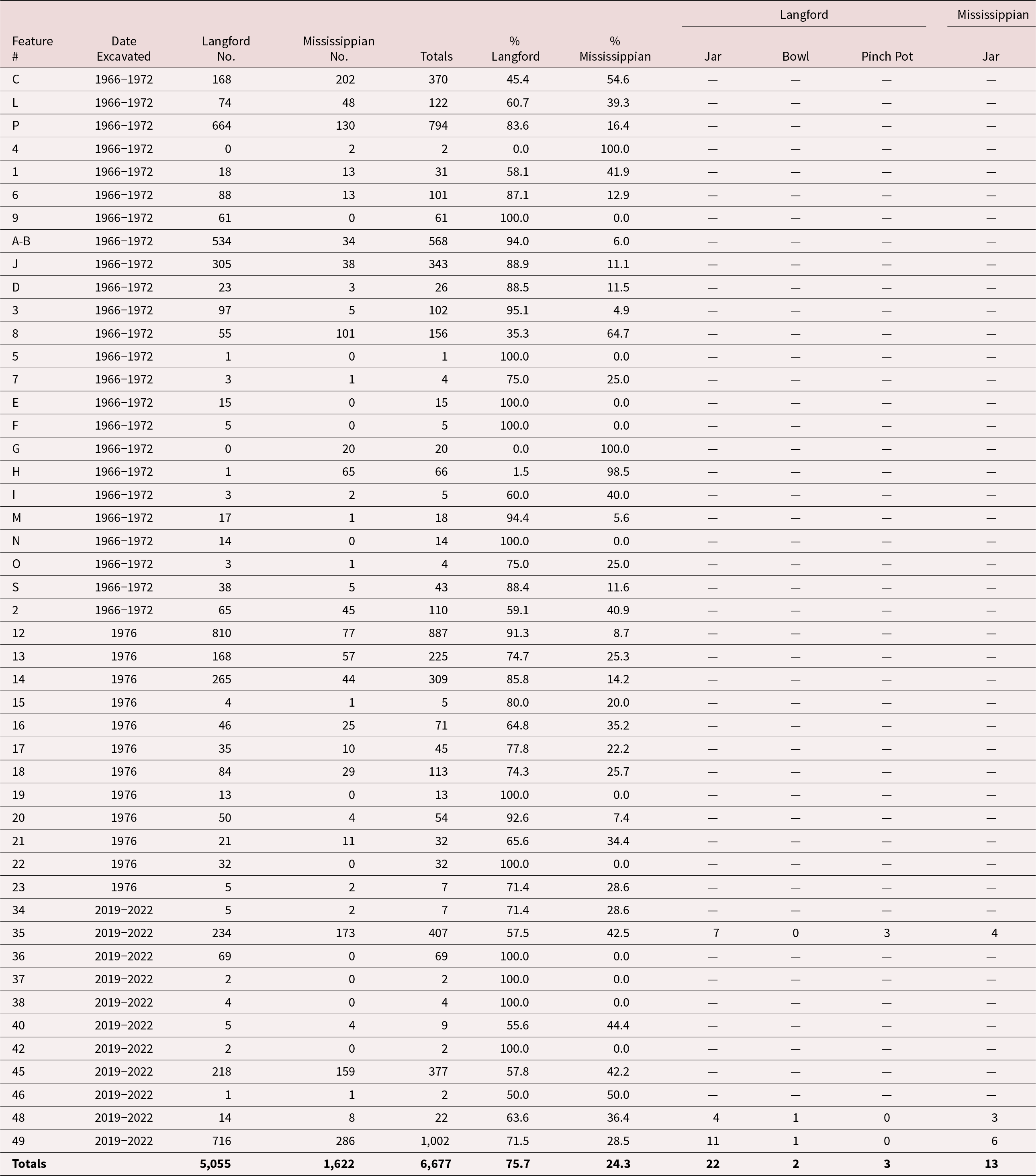


 Open access

