


Introduction
Climatic variability has been linked to the collapse of civilisations such as the Maya, Mochica and Tiwanaku, precipitating social change and population relocation to areas with more favourable conditions (DeMenocal Reference DeMenocal2001; Åkesson et al. Reference Åkesson2020). On the eastern flank of the Peruvian Amazon, settlements within the rainforest were favoured during drier periods, while wetter conditions prompted their abandonment (Åkesson et al. Reference Åkesson2020).
During the Early Holocene (c. 11 000–9000 BP), weakening of the South American Summer Monsoon reduced moisture transport, causing droughts (Bird et al. Reference Bird2011; de Carvalho & Cavalcanti Reference de Carvalho, Cavalcanti, de Carvalho and Jones2016; Mendonça Reference Mendonça2017). Amazonian and Andean palaeoclimatic records show multidecadal droughts between c. 8000 and 4000 BP (Binford et al. Reference Binford1997; Bush et al. Reference Bush2007; Mayle & Power Reference Mayle and Power2008; van Breukelen et al. Reference van Breukelen2008; Bird et al. Reference Bird2011; Kanner et al. Reference Kanner2013). The Late Holocene (past 4000 years) in the western Amazon and Andean piedmont saw increased rainfall, though this was intermittently reduced by El Niño-Southern Oscillation (ENSO) events (periodic warming (El Niño) and cooling (La Niña) of tropical Pacific sea surface temperatures and accompanying atmospheric vacillation), which can cause droughts across the Amazon Basin (Nobre et al. Reference Nobre2007, Reference Nobre2013; Olivares et al. Reference Olivares2015; Jiménez-Muñoz et al. Reference Jimenez-Muñoz2016; Papastefanou et al. Reference Papastefanou2022).
El Niño-related droughts coincide with major cultural and demographic shifts in pre-Columbian Amazonia at c. 1500, 1000, 700 and 400 BP (Meggers Reference Meggers1994). While once linked to cultural collapse, recent work shows varied responses to major climatic events: some societies reorganised, others adapted via polyculture agroforestry (McKey et al. Reference McKey2010; Clement et al. Reference Clement2015). Past El Niño events may have caused longer droughts than more recent ones, such as the most recent events in 1982–1983, 1997–1998 and 2022–2023 (Marengo et al. Reference Marengo2008; Gutierrez-Villarreal et al. Reference Gutierrez-Villarreal2024; Mamani et al. Reference Mamani2025), but modern data show that the El Niño reduces oceanic moisture transport to the Amazon, resulting in droughts and climatic warming (Jiménez-Muñoz et al. Reference Jimenez-Muñoz2016). These droughts often hit ecological transition zones harder, raising fire risk (Davidson et al. Reference Davidson2012). Palaeoclimatic records indicate that El Niño activity has been prevalent over the past 7000 years (Rodbell et al. Reference Rodbell1999; Moy et al. Reference Moy2002; Schneider et al. Reference Schneider2018; Nascimento et al. Reference Nascimento2020; Mark et al. Reference Mark2022), potentially influencing settlement patterns.
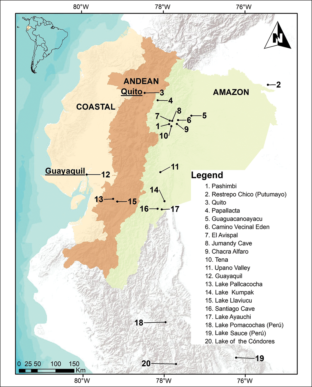
Yet, archaeological evidence shows long-term occupation of the eastern Andean flank (Arellano Reference Arellano2019; Solórzano Reference Solórzano2021; Rostain et al. Reference Rostain2024), challenging the idea that hyper-humid (>3m yr⁻¹) Andean sites were unsuitable for settlement (Lanning Reference Lanning1967; Insel et al. Reference Insel2010; Chavez & Takahashi Reference Chavez and Takahashi2017). Pre-Columbian (before c. 458 BP) land use left lasting ecological legacies in Amazonian forests, from species-composition changes to the creation of anthropogenic soils that enhanced productivity, while floodplain settlements balanced fertile gains with hydrological risks (McMichael et al. Reference McMichael2014; Flores et al. Reference Flores2017; Levis et al. Reference Levis2017). Evidence arising from the Early Holocene suggests that humid sites were not avoided. For instance, early hunter-gatherer activity is attested at Guaguacanoayacu, whose lithic assemblage dates to 9850±60 BP (Sánchez Reference Sánchez1998), while Archaic groups occupied El Avispal between 9180 and 9000 BP (Ugalde More Reference Ugalde More2014). Formative villages subsequently appeared along the Restrepo Chico tributary (Putumayo) from 3960–3090 BP (Arellano Reference Arellano2019), followed by Regional Development settlements in the Upper Napo River between 2530 and 1535 BP. By 1450–450 BP, more than 30 radiocarbon-dated sites, among them Camino Vecinal Edén (1600–1410 BP) and Chacra Alfaro (1410–1308 BP), had been established on high terraces and levees, illustrating sophisticated adaptations to flood-prone landscapes (Evans & Meggers Reference Evans and Meggers1968; Ochoa Reference Ochoa2007; Solórzano Reference Solórzano2007). These demographic pulses coincide with a climate trajectory that shifted from strongly seasonal (12 000–4700 cal BP) to more humid conditions after 4700 cal BP (Athens & Ward Reference Athens and Ward1999; Weng et al. Reference Weng2002).
Evidence of pre-Columbian human occupation during the Late Holocene has been identified, although the role of droughts in the settlement process of this period remains uncertain (Solórzano Reference Solórzano2021; Rostain et al. Reference Rostain2024). The presence of urban centres, platforms and geometric structures in the Upano region indicates human occupation dating back to at least 2500 BP (Rostain et al. Reference Rostain2024). A sequence of six occupation phases has been identified at the Pashimbi archaeological site 140km north of the Upano Valley (Figure 1; Solórzano Reference Solórzano2021). Although this site lacks the diversity of constructions observed in the Upano Valley, human occupation at Pashimbi began two millennia earlier (Solórzano Reference Solórzano2021). Based on 17 dates obtained from charcoal fragments, the occupation sequence at Pashimbi indicates that settlements were established there by c. 4025 BP (Dominguez Sandoval Reference Dominguez Sandoval2016; Solórzano Reference Solórzano2021). The charcoal fragments were likely produced by human activities, as fires do not occur naturally in the very humid regions of the Amazon (Piperno & Becker Reference Piperno and Becker1996; Glaser Reference Glaser2007; Maezumi et al. Reference Maezumi2018), and the presence of ceramic fragments at the same depth as the charcoal confirms its human origin (de Souza et al. Reference de Souza2019; Solórzano Reference Solórzano2021).
The three physiographic regions of Ecuador and the locations of archaeological and palaeoecological sites mentioned in the text (figure by B. Tumbaco).

Figure 1 Long description
A map of Ecuador highlighting its three physiographic regions: Coastal, Andean, and Amazon. The map marks various archaeological and palaeoecological sites, including Quito, Guayaquil, and several lakes and caves. The legend lists the names and numbers of these sites, providing a reference for their locations on the map. The map uses different colors to distinguish the regions and includes a scale for distance measurement.
The main objective of this study is to assess whether human occupation at Pashimbi was continuous or experienced interruptions from climate events similar to those in northern Peru or the Amazon (Åkesson et al. Reference Åkesson2020). The second objective is to determine whether El Niño influenced the patterns of occupation and abandonment among Amazonian populations at Pashimbi. Although differing by approximately 2500m in elevation and 250km in distance, the palaeoclimatic record from Llaviucu Lake (3115m above sea level (masl)) was used as a proxy for Pashimbi as it aligns with other El Niño activity records that reflect regional rather than local patterns (Rodbell et al. Reference Rodbell1999; Moy et al. Reference Moy2002). Isotope-enabled general-circulation models and observational networks show that El Niño-related anomalies in precipitation (determined through variations in the oxygen isotopic ratio, δ18O) are coherent along the eastern Andean flank and the adjacent Amazon piedmont, despite strong topographic gradients (Vuille Reference Vuille1999; Vuille et al. Reference Vuille2003; Vimeux et al. Reference Vimeux2005; Vuille & Werner Reference Vuille and Werner2005).
Study area
The Pashimbi archaeological site lies 8km from Tena, Napo Province, at 596masl (Figure 1). It is positioned on the eastern Andean flank, on an alluvial terrace along the right bank of the Tena River and west of the Colonso River (Guzman et al. Reference Guzman2019; Solórzano Reference Solórzano2021). The Pashimbi site has a humid tropical climate, with over 3m of annual rainfall and an average temperature of 25°C. Precipitation and temperature show little seasonal variation, and humidity stays above 80% year round. Soils of the floodplains, on which the settlements developed, are mainly silty and sandy, while local basalt, diorite and andesite were used to craft lithic artefacts, evidencing human activity between 4025 and 183 BP (Solórzano Reference Solórzano2021).
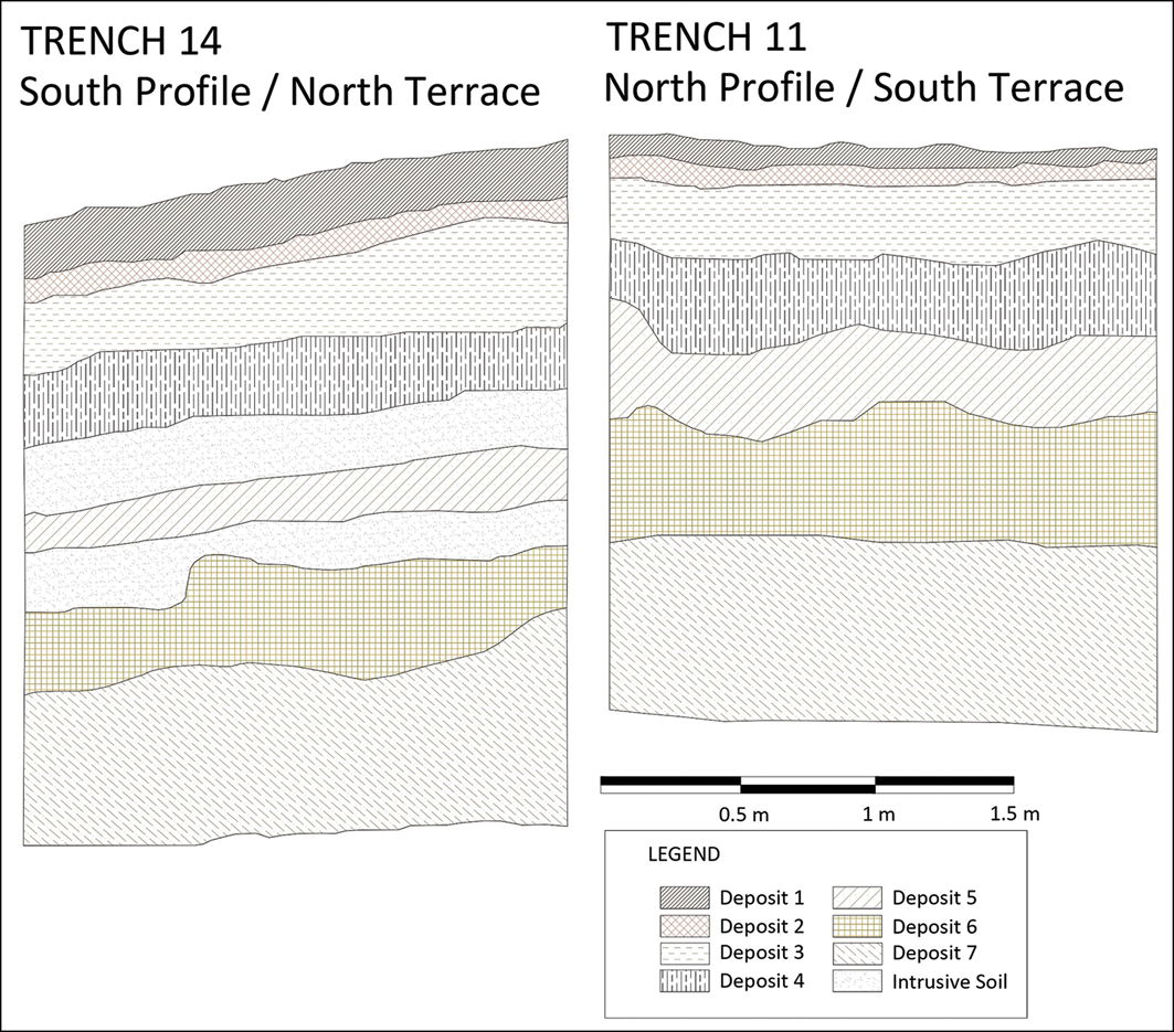
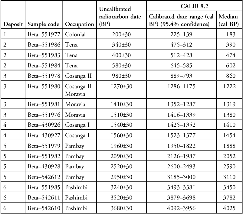
The stratified archaeological sequence at Pashimbi spans seven clearly defined deposits (Figure 2). Six of the seven deposits show evidence of anthropogenic activity (charcoal or ceramics), only the basal deposit 7 represents the soil prior to human occupation. The earliest cultural phase, the Pashimbi phase (4092–3381 cal BP; deposit 6), is associated with preceramic anthropogenic features, including stone arrangements interpreted as ritual altars. The overlying Pambay phase (3185–1822 cal BP; deposit 5) contains abundant ceramics and lithics indicative of increased landscape modification and interregional exchange. Deposit 4 corresponds to Cosanga I (1523–1352 cal BP) and is followed by the Moravia phase (1416–1287 cal BP; deposit 3), where well-defined domestic features such as house floors, post moulds from circular structures and food preparation areas, and high concentrations of obsidian and ceramics were found. Deposit 2 comprises the Tena phase (645–312 cal BP), characterised by circular posthole structures and common utilitarian ceramics. Finally, the Colonial phase (225–139 cal BP) is confined to the uppermost layers of deposit 1, with evidence of hybrid ceramic technologies. The chronological resolution provided by 17 calibrated radiocarbon dates obtained from across these six anthropogenic deposits (Table 1) reinforces the interpretation of a continuous but dynamic sequence of occupation, transformation and abandonment phases in response to both cultural and environmental shifts.
Stratigraphic profiles of trenches 14 and 11 (adapted from Solórzano Reference Solórzano2021: fig. 2).

Figure 2 Long description
The image presents a cross-sectional diagram of two trenches, labeled Trench 14 on the left and Trench 11 on the right. Each trench profile displays multiple layers of soil deposits, identified by different patterns and colors. Trench 14, labeled South Profile / North Terrace, shows seven distinct deposits, each marked with unique patterns. Similarly, Trench 11, labeled North Profile / South Terrace, also displays seven distinct deposits. A legend at the bottom right of the image explains the patterns corresponding to each deposit, labeled from Deposit 1 to Deposit 7, along with Intrusive Soil. The scale at the bottom indicates measurements in meters, ranging from 0.5 meters to 1.5 meters.
Calibrated radiocarbon dates from the Pashimbi archaeological site (data adapted from Solórzano Reference Solórzano2021).

Table 1 Long description
The table presents calibrated radiocarbon dates from the Pashimbi archaeological site, detailing seven deposits with evidence of human activity. Each deposit contains multiple samples with uncalibrated and calibrated radiocarbon dates. Deposit 1 includes a Colonial sample with a calibrated date range of 225 to 139 cal BP. Deposit 2, associated with the Tena phase, has three samples with calibrated date ranges from 475 to 312 cal BP, 512 to 428 cal BP, and 645 to 585 cal BP. Deposit 3, linked to the Cosanga II and Moravia phases, features samples with calibrated date ranges from 889 to 793 cal BP, 1286 to 1175 cal BP, 1352 to 1287 cal BP, and 1416 to 1339 cal BP. Deposit 4, corresponding to the Cosanga I phase, includes samples with calibrated date ranges from 1425 to 1352 cal BP and 1523 to 1377 cal BP. Deposit 5, part of the Pambay phase, has samples with calibrated date ranges from 1950 to 1822 cal BP, 2126 to 1987 cal BP, 2600 to 2493 cal BP, and 3185 to 3000 cal BP. Deposit 6, associated with the Pashimbi phase, contains samples with calibrated date ranges from 3493 to 3381 cal BP, 3879 to 3698 cal BP, and 4092 to 3956 cal BP. The table provides a detailed chronological framework for the site's occupational phases.
Llaviucu Lake, also known as Surucucho (Colinvaux et al. Reference Colinvaux1997), is located in Cajas National Park in the Western Cordillera of the Andes at an elevation of 3115masl (Figure 1). It has andosol and histosol soils with clay rich in aluminium and organic carbon (Nascimento et al. Reference Nascimento2020). The formation of this lake was due to glacial activity (Colinvaux et al. Reference Colinvaux1997; Buytaert et al. Reference Buytaert2007). The area has an annual temperature between 11 and 12°C and annual precipitation exceeding 2000mm (Nascimento et al. Reference Nascimento2020). The period of lowest precipitation in this region occurs between June and September, coinciding with the southern hemisphere winter (Michelutti et al. Reference Michelutti2016).
Methods
To determine the periods of occupation and abandonment at the Pashimbi archaeological site, the 17 calibrated radiocarbon ages were used to generate a probability density function (PDF) with the Bchron package v.4.1.1 in R (Parnell Reference Parnell2016). A threshold density was set at 0.00004 from 4000 years BP onwards, where densities greater than 0.00004 indicate periods of human occupation, while those equal to or less than 0.00004 indicate abandonment. This method allows for a probabilistic reconstruction of human occupation through time based on the presence of charcoal fragments as indicators of settlement.
Palaeoclimatic data were derived from the analysis of 26 chemical elements identified through x-ray fluorescence (XRF) in a 12.3m sediment core extracted from Llaviucu Lake and cross-referenced with the age model based on 16 radiocarbon samples taken from the core (Nascimento et al. Reference Nascimento2020). Elemental data were interpolated with an annual resolution for the past 5000 years and analysed using principal component analysis (PCA) with the Vegan package (version 2.7-2) in R (Oksanen et al. Reference Oksanen2025). The PCA reduced the data dimensionality from the 26 elements (26 dimensions), revealing a principal component (PC1) that explained 98.42% of the variance. A wavelet analysis was performed on PC1 using the R package biwavelet (version 0.20.22) to analyse frequency and phase variations over the past 5000 years (Gouhier et al. Reference Gouhier2024; Díaz & Villegas Reference Díaz and Villegas2022). Although the dates from the Pashimbi site reach 4000 years, the wavelet analysis was conducted using 5000 years to eliminate the cone of influence effect for ages earlier than 4500 years (Torrence & Compo Reference Torrence and Compo1998).
Wavelet analysis is a technique that allows the decomposition of a time series into time-frequency space. In other words, it identifies if there are oscillations (periodicities) within a dataset where points are taken at constant time intervals (time series, Figure 3B). The decomposition is depicted as a heatmap (Figure 3C), where time is shown on the x-axis and periodicities on the y-axis. The Morlet wavelet was used to prioritise frequency resolution and to be consistent with previous studies (e.g. Kravchenko et al. Reference Kravchenko2011), allowing the comparison of results. The wavelet analysis produced a heatmap that differentiates periods with and without significant El Niño influence (Torrence & Compo Reference Torrence and Compo1998). Wavelet transforms enable the detection of non-stationary periodic signals, making it possible to identify the timing, intensity and recurrence intervals of El Niño activity throughout the Holocene. The wavelet heatmap represents a 25 × 4500 matrix that was reclassified by assigning a value of 1 to significant regions that have periodicities of 2–8 years matching El Niño frequencies (red areas within a dark line in Figure 3C). Non-significant regions were assigned the value 0.
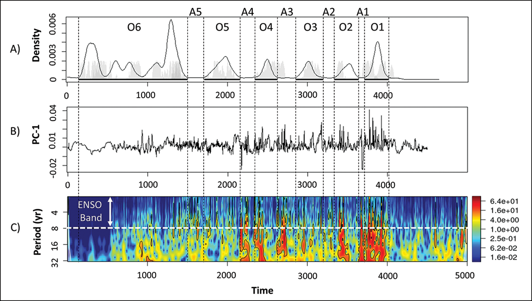
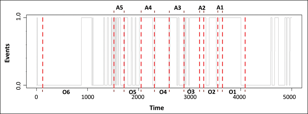
Comparison of occupation and abandonment phases at the Pashimbi archaeological site and ENSO data from Llaviucu Lake: A) probability density function (PDF) for Pashimbi (O=occupation; A=abandonment); B) principal component 1 (PC1) signal; and C) wavelet analysis of PC1 (ENSO band with 2- to 8-year periodicities), showing significant regions outlined in black within the heat map (figure by B. Tumbaco).

Figure 3 Long description
The image contains three graphs comparing occupation and abandonment phases at the Pashimbi archaeological site with ENSO data from Llaviucu Lake. The first graph, labeled A, is a probability density function (PDF) showing occupation (O) and abandonment (A) phases over time. The second graph, labeled B, displays the principal component 1 (PC1) signal over the same time period. The third graph, labeled C, presents a wavelet analysis of the PC1 signal, highlighting the ENSO band with 2- to 8-year periodicities. Significant regions within the heat map are outlined in black. The x-axis represents time, while the y-axis in graph C represents the period in years. The graphs illustrate the relationship between historical occupation patterns and climatic events.
The column values of the reclassified matrix were summed, resulting in a 1 × 4500 presence-absence matrix. A sum of zero in a column indicated the absence of El Niño (0), while values of one or higher indicated its presence (1). This matrix was subsequently used to quantify the number of El Niño events occurring within 20-year intervals across each occupation and abandonment period as identified by the PDFs. The frequency of events per period was standardised by the duration of each period. To assess data normality, a Shapiro–Wilk test was applied to the standardised frequency values for El Niño events across occupation and abandonment periods, followed by a Bartlett’s test to evaluate heteroscedasticity and determine if significant differences existed in the frequency of El Niño events between occupation and abandonment periods. These statistical tests ensured that the assumptions for parametric comparison were met.
Results
PDF analysis
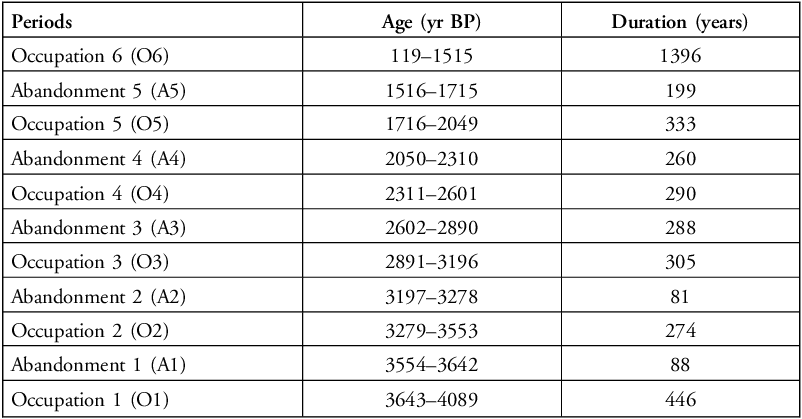
The probability density function generated using the 17 calibrated radiocarbon dates from the Pashimbi archaeological site (Solórzano Reference Solórzano2021) indicates six periods of occupation (O1–O6) and five periods of abandonment (A1–A5; Table 2; Figure 3A). The cumulative periods of occupation identified with densities greater than 0.00004 represent 3044 years and the cumulative abandonment periods represent 916 years.
Calculated occupations and abandonments at Pashimbi.

Table 2 Long description
The table presents data on periods of occupation and abandonment at Pashimbi, detailing the age in years before present (BP) and the duration in years for each period. It includes six occupation periods and five abandonment periods. Each row lists the period, its age range, and duration. For example, Occupation 6 spans from 119 to 1515 years BP and lasts 1396 years, while Abandonment 5 ranges from 1516 to 1715 years BP and lasts 199 years. The table highlights the cyclical nature of occupation and abandonment at the site.
PCA analysis
Principal component analysis of the 26 geochemical elements interpolated annually indicates that 98.42% of the variance can be explained by the first eigenvalue, PC1. The retained variance for PC2 and PC3 was 0.79% and 0.28%, respectively, and the variance explained by PC4 to PC26 totals 0.5%.
Wavelet analysis
The wavelet analysis applied to the PC1 time series generated a heat map with periodicities below 32 (y-axis). The periodicities corresponding to El Niño (2–8 years) are represented in the first 25 rows, covering the past 4500 years (4500 columns) (Figure 3). Regions with significant periodicities corresponding to El Niño events are shown in red in Figure 3C, within significance regions outlined in black. The cone of influence, an uninterpretable region in the wavelet analysis, appears as a white area in the first and last 50 years of the heat map (5000–4950 and 50–0 years, respectively; Torrence & Compo Reference Torrence and Compo1998).
El Niño events during periods of occupation and abandonment
The significance values for El Niño are shown in Figure 4, where values equal to 1 represent El Niño events identified for each period of occupation and abandonment over the past 4500 years. Zeros represent periods of El Niño absence. Table 3 shows the number of El Niño events identified by the wavelet analysis, grouped by periods of abandonment (A1–A5) and occupation (O1–O6). A total of 358 El Niño events are recorded during abandonment periods, and 701 El Niño events are recorded during occupation periods.
Relationship between occupation and abandonment phases and El Niño activity through time. The x-axis shows time in years before present (BP). The y-axis indicates the occurrence of El Niño events (event presence/absence). O1–O6 mark periods of occupation, and A1–A5 mark periods of abandonment. Vertical dashed lines highlight the timing of El Niño events, and the occupation (O) and abandonment (A) phases are delimited by the red lines, allowing comparison between event frequency and occupation/abandonment intervals (figure by B.Tumbaco).

Figure 4 Long description
The line graph illustrates the relationship between occupation and abandonment phases and El Nio activity over time. The x-axis shows time in years before present (BP), ranging from 0 to 5000. The y-axis indicates the occurrence of El Nio events, with values ranging from 0.0 to 1.0. Periods of occupation are marked as O 1 to O 6, and periods of abandonment are marked as A 1 to A 5. Vertical dashed lines highlight the timing of El Nio events. The occupation (O) and abandonment (A) phases are delimited by red lines, allowing comparison between event frequency and occupation/abandonment intervals. All values are approximated.
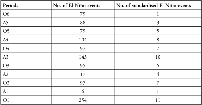
Number of ENSO events associated with each period.

Table 3 Long description
The table presents data on the number of El Niño events and standardized El Niño events across various periods labeled O6, A5, O5, A4, O4, A3, O3, A2, O2, A1, and O1. It consists of three columns: Periods, No. of El Niño events, and No. of standardized El Niño events. The table has 11 rows, each representing a different period. Notable data points include the highest number of El Niño events in period O1 with 254 events and the lowest in period A1 with 6 events. Period A3 shows the highest number of standardized El Niño events with 10, while periods A1 and O6 each have only 1 standardized event.
Using the significance values, a frequency graph with 20-year intervals was generated (Figure 5), showing the relationship between occupation and abandonment periods and the number of events. Normalisation of El Niño-event frequency indicates 37 events overlapping with occupation phases and 31 with abandonment phases (Table 3).
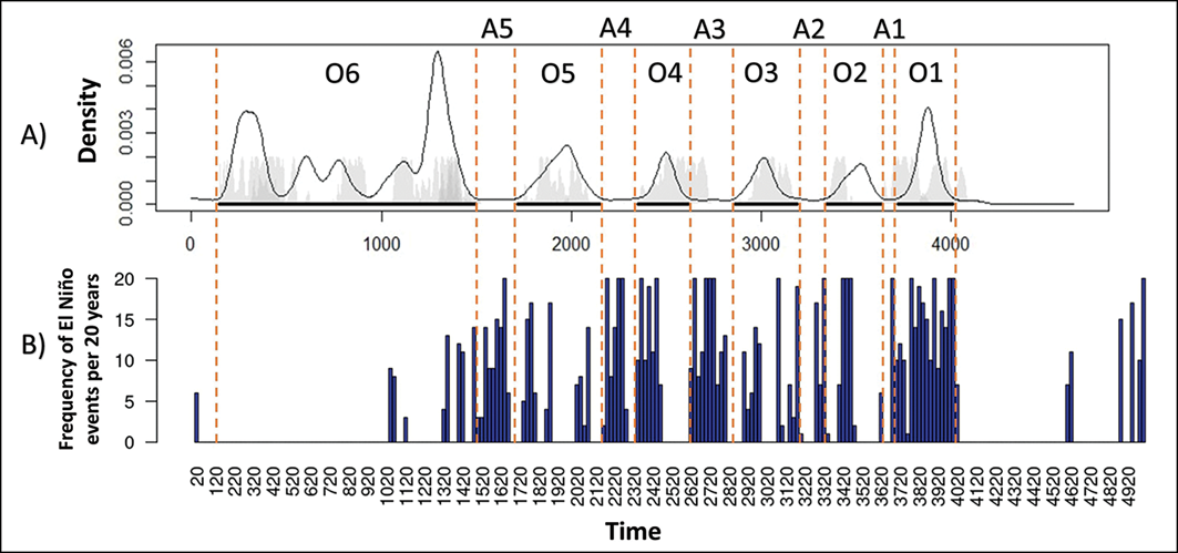
Relationship between occupation and abandonment periods and the amount of ENSO activity every 20 years. The x-axis shows time in years before present (BP). A) probability density function (PDF) for Pashimbi, showing the temporal probability of occupation phases (O1–O6) and abandonment intervals (A1–A5), delimited by the vertical dashed lines; B) frequency of El Niño (ENSO) events standardised in 20-year bins (figure by B. Tumbaco).

Figure 5 Long description
The line graph consists of two parts. Part A shows the probability density function for Pashimbi, indicating the temporal probability of occupation phases labeled O 1 to O 6 and abandonment intervals labeled A 1 to A 5, delimited by vertical dashed lines. Part B displays the frequency of El Nio events standardized in 20-year bins. The x-axis represents time in years before present, ranging from 0 to 4000. The y-axis in Part A represents density, while the y-axis in Part B represents the frequency of El Nio events per 20 years. The graph illustrates variations in occupation and abandonment periods in relation to ENSO activity over time. All values are approximated.
Application of the Shapiro–Wilk test to the standardised data for occupation and abandonment periods produced p-values of 0.3393 and 0.7648, respectively, indicating data normality. Subsequent testing of homogeneity with Bartlett’s test yielded a p-value of 0.9026, showing no significant difference between standardised El Niño events during occupation and abandonment periods.
Discussion
Is human occupation at Pashimbi continuous or discontinuous?
The PDF for Pashimbi identifies five periods with probabilities less than or equal to 0.00004, indicating abandonment and, therefore, discontinuous occupation (Figure 3A). These abandonment sequences are defined by the absence of dates matching the five abandonment periods, alternating with six occupation periods. The identified abandonments align with transitions between archaeological occupations such as Colonial, Tena, Moravia, Cosanga II, Cosanga I, Pambay and Pashimbi, which were originally identified based on stratigraphic and archaeological differences between deposits and are thus independent of our results (Solórzano Reference Solórzano2021). Similar abandonment patterns are seen in palaeoecological records from Ayauchi and Kumpak lakes in southern Ecuador (Åkesson et al. Reference Åkesson2023).
The link between settlement patterns and climate remains debated in Amazonian archaeology. Meggers (Reference Meggers1994) proposed that mega-Niño events, with high temperatures and extreme droughts, caused major discontinuities in the archaeological record (c. 1500, 1000, 700 and 400 BP). Arellano (Reference Arellano2019) argues that such events do not explain Amazon depopulation, while Åkesson and colleagues (Reference Åkesson2020) suggest that dry climates could have fostered population growth. Precipitation fluctuations induced by El Niño events may have influenced settlement processes, promoting resilience strategies such as polyculture agroforestry (McKey et al. Reference McKey2010; Clement et al. Reference Clement2015), forest enrichment (Levis et al. Reference Levis2017) and fire-based land transformation (Maezumi et al. Reference Maezumi2018; Mamani et al. Reference Mamani2025).
What was the influence of El Niño on the Pashimbi settlements?
Bartlett’s homogeneity test shows no significant difference (p = 0.9026) in the frequency of El Niño events between occupation and abandonment periods, without specifying event magnitude. Comparison of El Niño records from Llaviucu and Pallcacocha lakes (Rodbell et al. Reference Rodbell1999; Moy et al. Reference Moy2002), detailed in the online supplementary material (Figures S1 & S2, Table S1), shows no significant difference between the two datasets (Χ-squared = 0.14343, p = 0.7049), indicating a similarity in El Niño signal detection over the past 4500 years. Isotopic studies show that precipitation variability in the tropical Andes is consistent with western Amazonia, supporting the use of high-Andean palaeoclimatic records as proxies for broader regional hydroclimatic conditions (Vuille et al. Reference Vuille2003; Vuille & Werner Reference Vuille and Werner2005; Mosblech et al. Reference Mosblech2012). A δ18O analysis from the Caverna Jumandy, located 11km north-east of Pashimbi, exhibits strong coherence with tropical Pacific sea-surface temperature anomalies observed in Andean and Amazonian records (Jiménez-Iñiguez et al. Reference Jimenez-Iñiguez2022). Likewise, research at Papallacta, a transitional zone between the Andes and the Amazonian foothills, shows that vegetation and soil moisture have responded to El Niño events and the South American Summer Monsoon over the past 5000 years (Ledru et al. Reference Ledru2013, Reference Ledru2022). These findings support the use of regional proxies such as Llaviucu Lake to interpret climate-related occupation dynamics at Pashimbi.
The Pashimbi area, located on the eastern flank of the Andes, is today an extremely humid region with abundant rainfall for most of the year (with an annual precipitation of 4000mm). However, the prevalence of El Niño events may have altered climatic conditions in the past, reducing precipitation and making the area dry and more suitable for community settlement and agricultural practices at the onset of occupations (4089–3643 BP and 3553–3279 BP; Figure 5B). This settlement process associated with moisture reduction is also evidenced in palaeoecological records from lakes such as Sauce and Pomacochas (Bush et al. Reference Bush2016, Reference Bush2017; Åkesson et al. Reference Åkesson2020), where an increase in agricultural activity is observed during these dry episodes in the northern Peruvian Amazon. The abandonments that interrupted the initial occupation period may have been associated with the return of extremely humid conditions. These periods correspond to abandonments 1 and 2 at Pashimbi (Figure 5B; 3642–3554 BP and 3278–3197 BP) and are consistent with abandonment periods observed in the Lake Cóndores record (Åkesson et al. Reference Åkesson2020).
The discontinuities in human settlements were possibly associated with flooding caused by increased precipitation during La Niña events (Arellano Reference Arellano2019). Archaeological evidence in the Pashimbi region shows the existence of settlements established on alluvial terraces (Guzman et al. Reference Guzman2019; Solórzano Reference Solórzano2021), indicating that these settlements were vulnerable to flooding. The archaeological presence of settlements on alluvial terraces and nearby flood-prone areas is prevalent in the Amazon basin (Colinvaux et al. Reference Colinvaux1988, Reference Colinvaux1997; Athens Reference Athens1997; Athens & Ward Reference Athens and Ward1999) and areas adjacent to the Napo River (Weng et al. Reference Weng2002), highlighting the spatial scale and magnitude of abandonment that would have been necessary in response to flooding events.
Figure 5 shows two patterns. From occupation 3 to the present (3196–119 BP), covering the Colonial, Tena, Cosanga II, Moravia and Cosanga I phases (Solórzano Reference Solórzano2021), El Niño events were more frequent during abandonment phases (A3 = 10, A4 = 8, A5 = 9 per 20-year interval). Occupations in this same period recorded fewer events (O3 = 6, O4 = 7, O5 = 5, O6 = 1), generally under more humid conditions. Earlier occupations (3197–4089 BP) appear linked to comparatively drier El Niño phases with fewer abandonment pulses. However, as Bartlett’s homogeneity test (p = 0.9026) shows no significant difference in the frequency of El Niño events during occupation and abandonment periods, El Niño events are not the main driver of occupation or abandonment.
Ultimately, our data indicate that the temporally transgressive effects of El Niño influenced human occupation over the past 4500 years. However, occupation and abandonment processes may also have been driven by unidentified factors. El Niño is not the sole cause of Amazonian droughts. Sea surface temperature warming in the North Atlantic is also linked to droughts (Yoon & Zeng Reference Yoon and Zeng2010), and when both phenomena coincide, droughts intensify. Interactions between El Niño events and other drivers may explain observed patterns, but further palaeoclimatic reconstructions are required for validation.
Conclusions
Human occupation at the Pashimbi site was likely discontinuous over the past 4500 years. Several periods of abandonment associated with earlier settlements (Pashimbi, 4089–3643 BP; and Pambay, 3553–3279 BP) coincide with slight increases in the frequency of El Niño climatic events, suggesting that climate change had a role in disrupting occupation within the Amazon basin. However, overall, the difference in the frequency of these events recorded during periods of occupation and periods of abandonment is not statistically significant and over the past 3000 years, covering the Colonial, Tena, Cosanga II, Moravia and Cosanga I occupation phases, populations at Pashimbi appear to have adapted to wetter conditions. These results indicate that El Niño events were not the only, nor indeed the main, factor driving settlement choices in Pre-Columbian Amazonia.
Acknowledgements
The authors are grateful to Dr Mark B. Bush for providing the XRF dataset.
Funding statement
This research received no specific grant from any funding agency or from commercial and not-for-profit sectors.
Online supplementary material (OSM)
To view supplementary material for this article, please visit https://doi.org/10.15184/aqy.2026.10321 and select the supplementary materials tab.
Author contributions: using CRediT categories
Bruce Anthony Tumbaco Vega: Conceptualization-Equal, Data curation-Equal, Investigation-Equal, Methodology-Equal, Validation-Equal, Writing - original draft-Equal, Writing - review & editing-Equal. María Soledad Solórzano Venegas: Resources-Equal. Bryan G. Valencia Castillo: Resources-Equal, Supervision-Equal, Validation-Equal, Writing - review & editing-Equal.


 Open access