


In a review of cave burial practices in the lower Lahontan drainage basin (LLDB) of western Nevada, Thomas and colleagues (Reference Thomas, Cossette, Benner, Camp and Robinson2025) suggest that
Paleoindians began burying their deceased inside Lahontan Basin caves at least 11,000 years ago. This long-term trend is unique within the Intermountain West: Indigenous communities living elsewhere almost never buried ancestors in caves or rockshelters. These distinctive Paleoindian mortuary practices defined the Lahontan Basin as a uniquely spiritual space, rather than just some place to live [Reference Thomas, Cossette, Benner, Camp and Robinson2025:250; emphasis added].
However, in their endnotes, Thomas and colleagues (Reference Thomas, Cossette, Benner, Camp and Robinson2025:259) modify this by indicating there are “rare exceptions to this patterning,” and they list those exceptions in their Supplemental Text 1. This review is an attempt to clarify just how unique these cave burial practices may be.
The “Intermountain West” can be defined in several ways, and Thomas and colleagues (Reference Thomas, Cossette, Benner, Camp and Robinson2025; see also Thomas Reference Thomas2024:24, Figure 1.1) define it floristically. However, it is often described geographically as a region of western North America between Canada and Mexico to the north and south, and the Rocky Mountain Front Range and the Cascade/Sierra ranges to the east and west. This is a rather large area, so we restrict ourselves to a discussion of cave/rockshelter burial practices within the Great Basin of the Intermountain West by comparing those described by Thomas and colleagues (Reference Thomas, Cossette, Benner, Camp and Robinson2025) for the LLDB with those found within and adjacent the Bonneville basin (BB)—the Great Basin’s other major lake basin.Footnote 1 In addition, we review many of the open-air residential and nonresidential sites in the BB and LLDB that are also known to contain burials, given that such sites far outnumber those in caves and rockshelters in both number of sites and number of individuals buried. We suggest that ancestral members of the Washoe Tribe of Nevada/California and neighboring tribes who currently reside exclusively in California may have occupied many of the LLDB caves and open-air sites that contain burials.
The Nature of Cave Burials in the Bonneville Basin
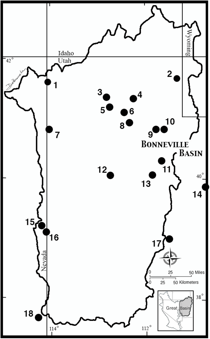
The BB is often thought of as the area of western Utah and eastern Nevada that was once covered by Late Pleistocene Lake Bonneville. However, the drainage system that fed—and continues to feed—that lake basin extends well beyond the margins of the Lake Bonneville highstand into the Colorado Plateau, parts of the Rocky Mountains, and parts of the Snake River drainage (Figure 1). Thomas and colleagues (Reference Thomas, Cossette, Benner, Camp and Robinson2025:259, Supplemental Text 1) list six cave/rockshelter sites in Utah containing prehistoric human remains, but there are more. Within the Bonneville drainage basin and its immediate surrounding margins, there are at least 18 such sites, which contain a minimum of 91 human burials and likely more (Supplementary Material 1). Directly dated skeletal remains from these caves span a period from approximately 10,750 to 1005 cal BP.Footnote 2
Approximate locations of cave/rockshelter sites with burials in the Bonneville basin discussed in the text: (1) Swallow Shelter; (2) 42RI176; (3) Hogup Cave; (4) Promontory Cave #2; (5) Homestead Cave; (6) Stansbury Cave #2; (7) Danger Cave; (8) Sandwich Shelter; (9) Black Rock Cave; (10) Deadman Cave; (11) American Fork Cave; (12) Camels Back Cave; (13) Spotten Cave; (14) Rasmussen Cave; (15) Lehman Cave; (16) Snake Creek Cave; (17) Sudden Shelter; (18) Etna Cave. Figure by Patti De Bunch.

The BB contains thousands of caves and rockshelters, many of them formed because of wave action in Lake Bonneville. Of these thousands, site records indicate that hundreds were occupied at one time or another over the course of human history in the basin. Of these hundreds, we do not know of any that lack evidence of vandalism. Given that many of the vandals specifically target human burials in search of artifacts (e.g., Sandwich Shelter, Rasmussen Cave), there is no way to know how many of these hundreds of caves may once have contained burials.
Although a few dozen of these caves have been excavated, the excavations have rarely removed all the cultural deposits, with substantial portions of those deposits sometimes left intact following the reported work (e.g., Hogup Cave, Danger Cave, Bonneville Estates Rockshelter [BER]). As a result, it is also impossible to know how many more burials may have been (or remain) in even the excavated sites. There are likely to have been (or to be) more. For example, the fragmentary human remains sometimes found in woodrat nests (e.g., Promontory Cave #2, Camels Back Cave, Swallow Shelter) suggest the presence of complete burials in the unexcavated portions of the sites.
With two major exceptions, all the burials in BB caves and rockshelters are found in what appear to represent “residential” sites, as opposed to what Thomas and colleagues (Reference Thomas, Cossette, Benner, Camp and Robinson2025) describe as “mortuary/cache” sites—which Thomas (Reference Thomas2024:187) defines as “special purpose” sites, along with other sites in which individual prey were targeted, such as during rabbit drives. For our purposes of comparison, by “residential” we mean places where people may have lived for only a few days, weeks at a time, or permanently, but where activities associated with daily living were carried out. In other words, “residential” sites contain hearths for cooking and warmth; abundant evidence of consumed foods (such as broken, splintered, and cut animal bones) and processed plant foods (such as pine-nut shells and pickleweed chaff); human fecal remains; “quids” (chewed and expectorated plant roots and rhizomes); and a broad array of tools, including multiple types of lithic tools (such as projectile points and various types of scrapers), woven tools (such as matting, winnowing trays, netting, and storage/carrying baskets), food preparation implements (such as manos and metates), pottery, and evidence of tool construction and repair (such as cores and flaking debris). Although not all of the caves in the BB contain all of these artifact types, all but the two exceptions discussed contain a sufficient number to qualify as residential sites.
With the exceptions of Lehman and Snake Creek Caves, all the BB caves and rockshelters described in Supplementary Material 2 contain stratified cultural deposits spanning periods lasting from over 12,000 years to “only” approximately 3,000 years. In other words, the stratified deposits represent residential occupations that took place over the course of roughly 480–600 human generations in the case of the former, to 120–150 generations in the case of the latter (using an estimated generational length of 20–25 years). None of these deposits appear to represent continuous or permanent occupations, of course; instead, they represent intermittent occupations by mobile foragers lasting a few days to a few weeks, and in a few rare cases (e.g., Danger Cave), perhaps a few months. They also do not represent three to 12,000 annual visits, given that all the sites contain layers of culturally sterile aeolian and/or eboulis deposits, and Bayesian analysis of 14C age estimates from several of them indicate the sites were abandoned for periods lasting from a few hundred years to a thousand years or more (e.g., Goebel et al. Reference Goebel, Hockett, Rhode and Graf2021; Martin et al. Reference Martin, Coltrain and Codding2017). As a result, it is impossible to determine whether the burials found in these caves represent interments associated with residential occupations at the site or interments that took place when no one was living there. The former seems to be the more parsimonious explanation, but the latter cannot be ruled out.
There are two remarkable exceptions to this general BB pattern of burials within residential cave sites: the natural trap caves on the eastern flank of the Snake Range—Lehman Cave and Snake Creek Cave—are karst caves that have (or had) narrow openings at the surface providing access to large solution caverns with floors some 9–12 m below the surface. In both cases, it would have been extremely difficult, verging on the impossible, to utilize the caves as residential bases, and the normal detritus of daily living associated with even short-term occupations is absent from the caves. In both cases, the recovered human remains consist of disarticulated skeletal elements that appear to have been deposited on the surface of the cave floors and subsequently disturbed by small animals. The nature of the ritual burial practices associated with the burials of the more than three dozen individuals interred at the two sites is difficult to evaluate scientifically. However, the two caves clearly served as special-purpose locations for burials, so some unknown ritual practices are implied. When those burials occurred and which precontact BB groups were associated with the burials are impossible to determine without direct dating or genetic analyses.
Open Site Burials in the Bonneville Basin
Bonneville-basin peoples also placed burials at open sites throughout most of the Holocene. Although it is not possible to enumerate those burials here, the number of those open site interments exceeds that of cave burials by an order of magnitude or more. Taphonomic processes likely impact our understanding of the earliest burial patterns in the BB, and only a single burial dating to the Paleoarchaic period is known. That burial comes from Deadman Cave and dates to approximately 10,750 cal BP. Thomas and colleagues (Reference Thomas, Cossette, Benner, Camp and Robinson2025) calculate that the seven dates from the Spirit Cave mummy in the LLDB have a median age of roughly 10,448 cal BP, so even though the age ranges of the two burials overlap statistically, the Deadman Cave burial may be slightly older. There are no known open site burials of Paleoarchaic age in the BB, but the Buhl burial—excavated from a gravel pit in the Snake River plain just to the northwest of the BB—may be of a similar age. The burial has been directly dated to ∼12,821–12,473 cal BP (10,675 ± 95 14C BP; Green et al. Reference Green, Cochran, Fenton, Woods, Titmus, Tieszen, Davis and Miller1998), but Jazwa and colleagues (Reference Jazwa, Smith, Rosencrance, Duke and Stueber2021) indicate that the collagen used in the dating process was degraded and that the true age is probably younger by some unknown amount. Regardless, a stemmed point, probably dating to the Paleoarchaic period, was found associated with the burial. In the BB, similar stemmed points date to between approximately 13,000 and 8500 cal BP (Madsen et al. Reference Madsen, Schmitt and Page2015).
The number of burials from open sites that have been directly dated to the Archaic period—from roughly 8500 to around 1600 cal BP—is small, again likely for taphonomic reasons. In addition to the nine directly dated cave/rockshelter interments from the basin, there are six from open sites (Rood Reference Rood2013). There is one near Sevier Lake; two from west of Utah Lake; one from Sandy, Utah; and two from the marshes of Great Salt Lake near Hooper, Utah. Most of these date to the middle Archaic period from about 6000 to around 4000 cal BP.
There is a substantial increase in the number of open site burials during the Fremont period, from ∼1600 to ∼650 cal BP, likely due to a combination of better preservation as a result of their younger age, the Fremont practice of placing burials in or near their village locations, and to the large number of these Fremont villages that have been excavated (Madsen and Lindsay Reference Madsen and Lindsay1977; Maughan Reference Maughan2025; Simms Reference Simms2008). Most of these burials have not been directly dated, but their ages can be closely estimated using 14C dates obtained from parts of the structures in which they were buried. For example, the disarticulated remains of nine individuals were recovered from a pithouse structure at Backhoe Village dated to ∼985 cal BP (1070 ± 100 14C BP) using a charred post from the structure floor (Madsen and Lindsay Reference Madsen and Lindsay1977; Novak and Kollmann Reference Novak and Kollmann2000). However, many Fremont burials in and around the marshes of Great Salt Lake have been directly dated under the guidance of the Northwestern Band of the Shoshone Nation (Simms and Stuart Reference Simms, Stuart and Gwynn2002). Simms (Reference Simms, Hemphill and Larsen1999) reports the dating of a large number of individual burials that were recovered following their disturbance by a high stand of the lake in the mid-1980s. Of the 57 directly dated individuals, 56 date to a period between approximately 1374 to roughly 610 cal BP. A single individual was directly dated to a slightly later time, but the transition between the Fremont and Late Prehistoric periods is chronologically very fuzzy (Madsen and Simms Reference Madsen and Simms1998), and the individual may well have been related to the rest of the dated group. The Fremont were also foragers as well as farmers, and virtually every major cave/rockshelter excavation in the BB has substantial Fremont occupations. As noted above, Fremont-aged burials have been directly dated at Black Rock and Deadman Caves, and burials at Danger and Spotten Caves are probably of a similar age.
Cave Burials in the Upper Lahontan Drainage Basin
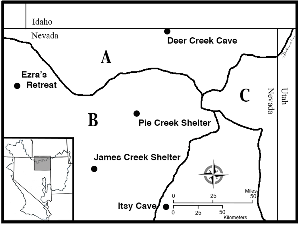
Three cave/rockshelter sites in the upper Lahontan drainage basin contain burials, in addition to two others along its margin, and these were not reported by Thomas and colleagues (Reference Thomas, Cossette, Benner, Camp and Robinson2025; Figure 2). Given that these sites are located between the BB and LLDB and may have been occupied at any one time by foragers from either region, they are reported here because they are important in terms of evaluating the postulated rarity of cave burials in the Intermountain West (see Supplementary Material 2 for site descriptions).
Location of cave burials in and near the upper Lahontan drainage basin: (A) Snake River drainage basin; (B) Lahontan drainage basin; (C) Bonneville drainage basin. Figure by Patti De Bunch.

Three of the sites contain at least minimal amounts of Fremont pottery, and all five of these upper-Lahontan-basin sites are within the foraging range of Fremont farmer/foragers (Madsen Reference Madsen2023:Figure 6). This suggests the possibility that at least some of the occupational debris—and, of course, some of the burials—may have been left by foragers from the BB. Just as plausibly, all five sites may have been occupied at times by people from the LLDB. Or, the sites may have been occupied throughout the time spans they represent by local groups who did not visit either of the two major lake basins. Any combination of these is possibile.
The Nature of Burial Practices in the Lower Lahontan Drainage Basin
Thomas and colleagues (Reference Thomas, Cossette, Benner, Camp and Robinson2025) compare radiocarbon records from “mortuary/cache caves” in the eastern and western LLDB to “residential” sites throughout the basin. Thomas and colleagues (Reference Thomas, Cossette, Benner, Camp and Robinson2025), relying on Thomas (Reference Thomas2024:26–29, 33, Figure 1.5) and the floristic definitions found in Cronquist and colleagues (Reference Cronquist, Holmgren, Holmgren and Reveal1972), do not include all the hydrographic drainages that contribute water to the LLDB. Instead, the upper hydrographic drainages east of the Stillwater Range and marshes, including most of the Humboldt River and its tributaries, are defined as the “Central Great Basin.” Consequently, their analysis involves only burial practices in the LLDB—the area once covered by the highstand of Pleistocene Lake Lahontan, and not the basin’s much larger watershed. Thomas and colleagues (Reference Thomas, Cossette, Benner, Camp and Robinson2025) do not define what makes a site “mortuary,” and they restrict the use of that term only to cave and rockshelter sites based on a review of their Supplemental Table 1. Like the BB review above, we utilize the more general term “burial” for human remains. In contrast, “cache” sites are places in which material remains such as textiles, tools, food, and personal belongings were stored; these generally small-scale features may be present within residential sites, as defined above, or singularly, in the absence of residential debris. For the LLDB, we ask two related questions:
1. Did the precontact mobile foragers of the LLDB ever bury their people at open residential sites, as did similar groups in the BB?
2. Did the peoples in the LLDB ever live in the caves and rockshelters where they sometimes buried their people, as did BB peoples?
Open Burial Sites in the Lower Lahontan Drainage Basin
Thomas and colleagues (Reference Thomas, Cossette, Benner, Camp and Robinson2025) provide a list of 165 14C age estimates for what they identify as LLDB “residential” sites. Of these, there is only a single age estimate from the Sulphur Springs site, which predates roughly 4200 cal BP. Although the lack of earlier dates could suggest that residential occupations in the LLDB were minimal prior to that time, the data may be misleading given that there are numerous undated open sites in the LLDB that contain both stemmed projectile points and crescents dating to the Pleistocene / Early Holocene (Adams et al. Reference Adams, Goebel, Graf, Smith, Camp, Briggs and Rhode2008; Camp Reference Camp2009; Dansie and Jerrems Reference Dansie, Jerrems, Bonnichsen, Lepper, Stanford and Waters2005; Mohr Reference Mohr2018), and there are Archaic point styles characteristic of the early-to-middle Holocene, around 9000–5000 cal BP (Hockett and Spidell Reference Hockett and Spidell2022). Radiocarbon-dated textiles and human skeletal remains from three subbasins within the LLDB (Pyramid Lake, Winnemucca Lake, and Carson Sink) dated within the Early Holocene (ca. 11,400–10,200 cal BP) led Adams and colleagues (Reference Adams, Goebel, Graf, Smith, Camp, Briggs and Rhode2008:619) to conclude the following: “Taken together, these directly dated cultural remains indicate intensive human use of the Lahontan basin immediately following the Younger Dryas period.” And, as is the case with the BB (Goebel et al. Reference Goebel, Hockett, Rhode and Graf2021; Hockett et al. Reference Hockett, Goebel and Graf2025), there is solid evidence that the Middle Holocene dry and warm period (ca. 9300–5500 cal BP) negatively impacted hunter-gatherer use of the Lahontan basin as well (Adams et al. Reference Adams, Goebel, Graf, Smith, Camp, Briggs and Rhode2008:620), although humans did not entirely abandon the region. For example, the recently excavated Huffaker Springs site located near the Truckee River (Figure 3), a major source of water for the LLDB, is a residential site radiocarbon dated to about 7900 cal BP within the Middle Holocene (Spidell and Kautz Reference Crema and Bevan2021).
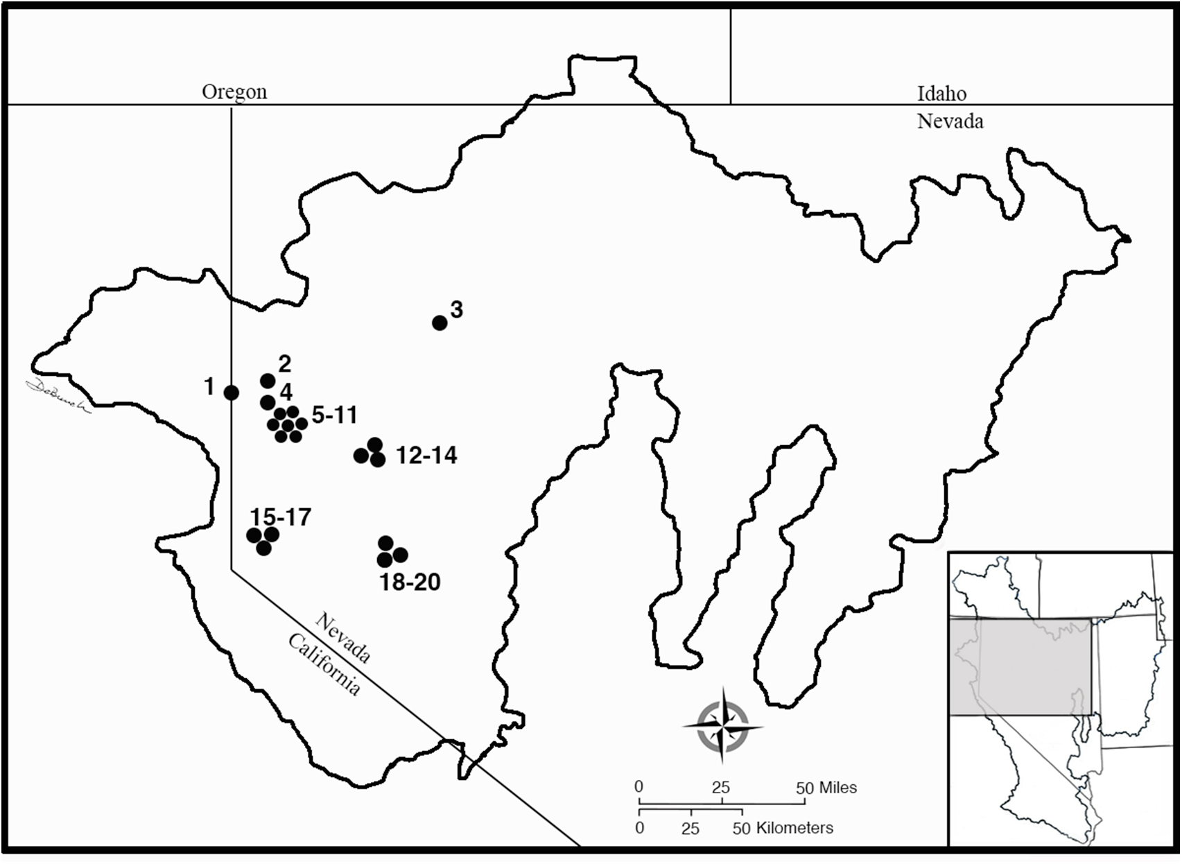
Location of the Lahontan drainage basin in northern Nevada and the approximate locations of LLDB archaeological sites mentioned in the text: (1) Karlo site; (2) Dryden Cave; (3) Elephant Mountain Cave; (4) Wizards Beach; (5–11) Chimney Cave, Crypt Cave, Guano Cave, Kramer Cave, Nicolarsen Cave, Shinners Site A, and Stick Cave; (12–14) Humboldt Lakebed site, Leonard Rockshelter, and Lovelock Cave; (15–17) Huffaker Springs site, Steamboat Hot Springs site, and Vista site; (18–20) Hidden Cave, Spirit Cave, and Stillwater Marsh sites. Figure by Patti De Bunch.

It is difficult to know if people were always “resident” in the definition used here at all the open sites that undoubtedly date to the Early Holocene based on projectile point typology. However, one thing is clear from the archaeological record of the Lahontan basin: following the difficult times during the Middle Holocene, by about 5000 cal BP, the climate was ameliorating and the intensity of hunter-gatherer use of the region was increasing. After about 5000 cal BP, we see increasing evidence of open sites with burials where there is evidence of structures; sites that are clearly “residential.” However, most open site burials in the LLDB appear to be isolated interments.
Even without an exhaustive study of open site burials in the Lahontan drainage basin, it appears that precontact groups often interred their people in or near places where they lived, as they did in the Bonneville drainage basin. Most of these residential open site burials date to the last 5,000 years or so, mostly because that is when sites with structures become more prevalent. Part of this may be due to preservation and taphonomic factors, and part may be due to a change in subsistence and settlement practices (e.g., Kelly Reference Kelly2001). LLDB peoples also placed burials in isolated, open-site, nonresidential locations, but these are not discussed here primarily because a great many of them were brought to the attention of federal land management archaeologists by members of the general public who stumbled upon the skeletal remains, and the details about them are not available in the published literature. A number of these burials are reported in Larsen (Reference Larsen and Thomas1985:Table 1). However, the earliest of these open, nonresidential site locations appears to be one of the three Wizards Beach burials (Figure 3), recovered from gravel deposits on the shores of Pyramid Lake (Dansie Reference Dansie1997; Jackson Reference Jackson2012). Four 14C age estimates for burial B employ slightly different methods and produce an average age of approximately10,660 cal BP (9427 ± 56 14C BP; Jackson Reference Jackson2012), making it contemporaneous with both Early Holocene–aged Spirit Cave burials (the individual referred to as “The Storyteller” in Thomas et al. [Reference Thomas, Cossette, Benner, Camp and Robinson2025], and a very differently treated individual who was cremated). The age of Wizards Beach burial A is controlled by a single 14C age estimate of around 6730 cal BP (5905 ± 125 14C BP), suggesting it dates to the early to mid-Archaic period in the LLDB within the Middle Holocene. The third burial is undated.
We use the presence of structures at open sites to identify “residential” sites that may be associated with burials. In the LLDB, there are more than 600 burials associated with dozens of such sites. Most of these are found in the Stillwater marsh area (Figure 3) of the Carson Sink (e.g., Raymond Reference Raymond1992), but they are common in other marsh areas throughout the LLDB. We provide a single example of this kind of site here and more in Supplementary Material 2. These examples also make clear that LLDB people often placed burials where they lived or nearby.
The Humboldt Lakebed site—the representative “residential” site with burials—lies on the floor of the Humboldt Sink, approximately halfway between Lovelock Cave and Leonard Rockshelter (Figure 3). The site has been excavated several times since the early 1900s, and dozens of house floors have been identified and mapped (Livingston Reference Livingston1986). Eight 14C age estimates for the site range between approximately 2800 cal BP (2690 ± 250 14C BP) and approximately 560 cal BP (550 ± 60 14C BP), although the recovery of well over a hundred Humboldt projectile points suggests much earlier occupations (Hockett and Spidell Reference Hockett and Spidell2022). Livingston (Reference Livingston1986) reports that a total of 24 burials were recovered over the course of the numerous excavations. Organic materials associated with a cremation burial produced a roughly 2800 cal BP age estimate (Bennyhoff and Heizer Reference Bennyhoff and Heizer1958).
Residential Cave Burial Sites in the Lower Lahontan Drainage Basin
A dichotomy between residential and nonresidential site occupations is difficult to apply to mobile foragers precisely because they are mobile—moving from place to place, staying at any one place for periods ranging from a few days to a few weeks to months at a time, splitting into small groups at times, and coming together into large groups for communal activities such as jackrabbit hunts. As a result, there are several questions that arise in applying such a dichotomy to mobile foragers. How many days do mobile foragers have to live at a place before it becomes “residential?” Do they have to stay long enough to build substantial structures, such as pithouses? Is the presence of less substantial structures, such as wickiups, sufficient to make a site “residential?” If substantial structures are required to make a site “residential,” how does one recognize “residential” occupations at caves and rockshelters where built structures are unnecessary? Is it even necessary for the mobile foragers to sleep at the site overnight as opposed to simply working at the site during the day? In short, the dichotomy between “residential” and, implicitly, “nonresidential” sites is difficult to apply to the Great Basin where, for the most part, people were mobile foragers throughout the occupational history of the region (brief ∼1,000-year periods of farming in the eastern and southern basin are exceptions).
Given that definitional difficulty, it is necessary to supply one here, particularly as it applies to the use of caves and rockshelters. As noted above in the discussion of BB cave burials, a site is considered to have been “residential” if it is a place where activities associated with daily living were carried out. Specifically, for caves and rockshelters in the Lahontan drainage basin, such sites are considered to have been “residential” if they contain stratified cultural deposits outside of caches or burial pits. These stratified cultural deposits should contain a combination of material remains related to daily living such as (1) an array of chipped stone tools, not just projectile points, together with lithic debris from the construction and maintenance of such tools; (2) ground stone tools, such as manos and metates for food preparation; (3) basketry, matting, netting, and cordage used in a variety of tasks; (4) hearths for cooking, warmth, and light; (5) evidence of food preparation, such as broken pine-nut shells, stringers of chaff resulting from seed winnowing, and broken, split, cut, and charred animal bones; and (6) human fecal remains. Although not all of this evidence may be present at any one site, there should be enough of these kinds of evidence of daily living activities to qualify the site as “residential.”
Cave/rockshelter sites in the Lahontan drainage basin with burials can be classified into three broad, overlapping categories: (1) sites with deeply stratified deposits spanning much of the Holocene; (2) sites with modest occupational records dating to short periods of the Holocene; and (3) sites containing only burials and/or caches with little or no occupational deposits. A few examples from each category are provided here.
Deeply Stratified Cave Sites
Cave sites with burials in the LLDB that have occupational records spanning much of the Holocene are probably most comparable to the deeply stratified sites in the BB, such as Danger and Hogup Caves. We provide descriptions of three of these sites in the LLDB because of their importance in demonstrating a continuing occupation of caves with burials. There are a number of other such caves in the LLDB, such as Dryden Cave (Basin Research Associates Staff 1986; Buckley Reference Buckley1986) and Shinners Site A (Hattori Reference Hattori1982; Figure 3), but these three sites are representative.
The most well-known of the sites with deeply stratified deposits is probably Lovelock Cave, located in the Humboldt Sink area of the Lahontan drainage basin (Figure 3). The cave has been the focus of two major excavation projects: that of Loud and Harrington (Reference Loud and Harrington1929) and one led by Robert Heizer in the late 1960s (Heizer and Napton Reference Heizer and Napton1970; see also Grosscup Reference Grosscup1960). There have also been numerous reports focused on material remains ranging from dried human coprolites (e.g., Ambro Reference Ambro1967; Heizer and Napton Reference Heizer and Napton1969) to projectile points (e.g., Clewlow Reference Clewlow1968; Clewlow and Napton Reference Clewlow and Lewis1970) to fish remains (Follett Reference Follett1970). Although the site had been seriously disturbed by guano collectors, enough intact areas of the site remained to establish a reliable stratigraphic and chronological record. These intact stratified deposits reached a depth of over 4.4 m in places, with an average depth of about 3.0–3.7 m. The major occupations at the site postdate about 5000 cal BP (Bennyhoff and Hughes Reference Bennyhoff and Hughes1987; Tuohy and Napton Reference Tuohy and Napton1986). The nature of these sediments is probably best described by Loud and Harrington (Reference Loud and Harrington1929):
The deposits consisted of desert dust blown in from outside, fragments of stone of varying sizes fallen from the roof, lime dust from the same source, bat-droppings or “guano,” all mixed with materials brought in by man or objects made by him, such as quantities of tule rushes and grass intended for bedding and other uses, sticks, arrow canes, pieces of broken baskets and worn-out mats, bones of food animals, bits of string and rope, hair, feathers, excreta, ashes, stray human bones, occasional implements of stone, wood, or bone, shell beads, sandals, and numerous other articles [Loud and Harrington Reference Loud and Harrington1929:5].
Loud and Harrington (Reference Loud and Harrington1929) estimated they removed the remains of at least 45 individuals, although more were probably disturbed by guano mining. Numerous cache pits were also uncovered, the most well-known of which is a cache of duck decoys. Despite this array of debris resulting from daily living, Heizer and Napton (Reference Heizer and Napton1970) suggest the site may not have seen “residential” use in the normal sense of the term. As they put it,
The enormous mass of artifacts from Lovelock Cave, probably amounting to more than 20,000 specimens, is an impressive collection. However, in examining the cave midden, we are equally impressed with what is not present. Absent, or nearly so . . . [are the] other kinds of debris that were usually produced in the course of daily living in occupation sites. . . . In short, there are enough anomalies in the Lovelock Cave occupational debris to suggest that part of the daily human activity that usually occurred in this type of Great Basin occupation site probably took place at some other location—most probably the lakeshore [Heizer and Napton Reference Heizer and Napton1970:43–44; emphasis added].
In other words, as at Hidden Cave (see below), part of the daily human activity of those who worked at the site appears to have taken place in the same place where people were buried, whereas other parts of daily activity took place elsewhere.
Elephant Mountain Cave, a large two-chambered cave in an isolated butte on the northwestern margin of the Black Rock Desert (Figure 3), has the longest relatively continuous record of residential occupation in the Lahontan drainage basin, “stretching from 10,000 years ago through ethnohistoric times” (Barker et al. Reference Barker, Ellis-Pinto and Valentine2011:1). The cave was systematically looted in the early 1980s, but, although nearly 95% of the intact deposits were destroyed, enough remained to provide an assessment of the cave stratigraphy and chronology. Although the original overall depth of the deposits is unknown, the cave stratigraphy preserves alternating natural and cultural depositions suggesting “the cave was occupied and abandoned repeatedly by different groups throughout aboriginal times” (Barker et al. Reference Barker, Ellis-Pinto and Valentine2011:5). At least five different occupational periods appear to be represented by diagnostic artifacts, with the earliest of these containing Paleoarchaic stemmed points and Fort Rock sandals. The earliest of the sandals dates to approximately 9900 cal BP (8830 ± 70 14C BP). The most intensive occupations date to a period between approximately 4500 and 700 cal BP. Given the predilection of looters to only keep the most complete artifacts, the nature of the residential occupations is difficult to ascertain. Certainly, the presence of projectile points, dried human coprolites, and fragments of textiles and sandals, together with “literally thousands of lithic artifacts” in the backdirt and “a pile of broken groundstone artifacts in front of the cave” (Barker et al. Reference Barker, Ellis-Pinto and Valentine2011:5–6) suggest that the deposits represent the remains of daily living. Two bundle burials dated to roughly 2350 cal BP (2330 ± 60 14C BP) and roughly 2410 cal BP (2360 ± 60 14C BP) were recovered from the looted collections, and there may have been an additional two other burials. Whether or not there were any caches in the cave prior to the extensive disturbance is unknown.
Hidden Cave overlooks the Carson Sink, south of the Stillwater marsh area, and directly above one of the main distributary channels of the Carson River (Figure 3). The cave consists of a large central chamber accessed by only a small opening, limiting visibility into the cave interior. Following preliminary work in the early 1940s, two major excavations were conducted at the site in the early 1950s (Roust and Grosscup Reference Roust and Grosscupca. 1950s) and in the late 1970s (Thomas Reference Thomas1985). Both excavations defined two major sets of laminated cultural depositions, which, in the words of Rhode (Reference Rhode2003:909), consisted of “dry stratified deposits [that] abound with fragments of baskets, nets, digging sticks, projectile points, and other tools that the Hidden Cavers used to extract plant and animal resources of the nearby marshes and desert.” Direct dating of dried human fecal remains suggests that two major periods of occupation occurred about 4030 cal BP (3690 ± 40 14C BP) to 3750 cal BP (3480 ± 40 14C BP) and about 1880 cal BP (1950 ± 35 14C BP) to 1390 cal BP (1520 ± 30 14C BP). Other radiocarbon dating from the site suggests that intermittent occupations took place both between these two major occupational intervals and slightly earlier (Thomas Reference Thomas1985). The earliest “cultural” radiocarbon date is approximately 6140 cal BP (5365 ± 90 14C BP) within the Middle Holocene, although chronologically diagnostic projectile points suggest even earlier visits (Thomas Reference Thomas1985:368). The disarticulated remains of at least five individuals were encountered over the course of all the excavations (Larsen Reference Larsen and Thomas1985). Like Lovelock Cave, Hidden Cave presents something of an interpretive conundrum, given a residential versus nonresidential dichotomy, because as Thomas (Reference Thomas1985:382) notes, “Lifespace considerations rule out residential use of Hidden Cave.” Yet, he also indicates that people, most of whom were probably women (Rhode Reference Rhode2003), were living and working in the cave on a diurnal basis (Thomas Reference Thomas1985). In other words, it seems that for a cave site to be classified as “residential,” its occupants must necessarily be sleeping there, rather than just working there during the day and sleeping outside at a nearby location. However, we want to know whether people were carrying out daily living activities in the same space where burials were placed. At Hidden Cave, they obviously were. As Ingbar (Reference Ingbar and Thomas1985) notes,
The complexity of Hidden Cave warns against the facile interpretation that this site served merely as a “cache cave.” . . . The site could, for instance, have served sporadically as a short-term camp, or as a specialized activity area associated with an open-air residential site [Ingbar Reference Ingbar and Thomas1985:329–330].
Cave Sites with Limited Occupational Sequences
Several caves and rockshelters that Thomas and colleagues (Reference Thomas, Cossette, Benner, Camp and Robinson2025) describe as “mortuary/cache” sites also contain occupational debris representing shorter periods of time. Only a single example of these is provided here, given that a complete assessment of short-term occupational intervals at many of the sites is difficult. This is because a number of these “mortuary/cache” caves were excavated over the course of only a few days in the late 1930s to early 1940s by Sydney Wheeler and Georgia Wheeler (Wheeler and Wheeler Reference Wheeler and Wheeler1969), in the early 1950s by Phil Orr and colleagues (Orr Reference Orr, Donald R. and Doris L.1974), and in the 1960s by Richard Shutler and Donald Tuohy (Shutler Reference Shutlerca. 1960s). Neither of the two earlier groups paid much attention to the details of stratigraphy or the collection of the more mundane types of cultural material such as small flaking debris. As a result, the notes and drawings are quite limited, and there was an obvious focus on the retrieval of burials and caches, as opposed to stratified occupational detritus. A number of studies have attempted to reconstruct the occupational sequences at these sites (e.g., Hattori Reference Hattori1982; Webb Reference Webb2017). They conclude there are more of these mortuary/cache caves that contain short-term “residential” occupations than the example provided below. Thomas (Reference Thomas2024) provides additional examples of caves that fit this category:
a few document limited Paleoindian habitation, including Kramer Cave, Fishbone Cave, and Elephant Mountain Cave. . . . Crypt Cave is another possibility. . . . Ancestral remains were documented inside Crypt Cave, accompanied by finely made grave furnishings, very fine netting, and a buckskin bag; a plaited mat from Crypt Cave dates to the Early Holocene. Orr (Reference Orr1952:20) interpreted Crypt Cave as “an intermittent habitation and burial site for a long period of time” [Thomas Reference Thomas2024:164].
Indeed, dating of a possible locust cache at Crypt Cave (Figure 3) to older than approximately 14,000 cal BP (Pellegrini et al. Reference Pellegrini, Hattori, Benson, Southon, Song and Woller2022) suggests that the site may represent the oldest occupation of the LLDB yet found.
Kramer Cave, one example of a cave with limited occupational intervals, is one of the Falcon Hill sites on the north end of Winnemucca Lake (Figure 3). The site is a rockshelter-like cave with a small, narrow opening (Hattori Reference Hattori1982). Hattori (Reference Hattori1982) suggests there was a short but intensive period of occupation at the site, with 10 14C age estimates dating to a period between approximately 4320 cal BP (3900 ± 100 14C BP) and 3940 cal BP (3620 ± 80 14C BP). The 10 dated samples were “obtained from artifacts recovered from throughout the deposits” (Hattori Reference Hattori1982:10). Only a single identified hearth is associated with this occupational interval, but the wide array of projectile points, other bifaces, bone tools, a variety of textiles and cordage, and ornaments suggest a period of “living” at the site during this relatively short interval.
Burial/Cache Caves with No Occupational Deposits
There are several sites in the LLDB that contain burials or caches but that contain no evidence they were occupied even on a diurnal basis. In several cases, such as Stick and Chimney Caves in the Winnemucca Lake subbasin (Orr Reference Orr1952; Webb Reference Webb2017; Figure 3), there is little or no “living space” due to extremely low ceilings, jumbled rockfall on the cave floors, or both. These sites were not likely to have been inhabited even had they not served as either mortuary or cache locations. On the other hand, sites such as Crypt Cave, Leonard Rockshelter, and Spirit Cave (Figure 3) have large open, protected cave/shelter floors, and potable water was available nearby during highwater periods. Yet, these sites contain little or no evidence of human occupation beyond the presence of caches and burials. This juxtaposition of equipment and food caches near human burials is of particular interest here because it implies that people were coming and going to sites where people had been buried, emptying and refilling them with material cached for later use. On the other hand, it is possible that some of these caches were related to the burials themselves, containing materials meant to accompany the deceased in the afterlife.
Comparing Burial Practices in the Bonneville and Lahontan Drainage Basins
Cave and rockshelter burials in the Bonneville drainage basin are fewer in number—in terms of either the number of sites or the number of burials—than those found in the Lahontan drainage basin. However, they are certainly not “rare” or even uncommon. How, then, are burial practices in the two major lake basins of the Great Basin either similar or different? Does the presence of these burials in caves make the BB (or the upper Lahontan drainage basin for that matter) “a uniquely spiritual space rather than just someplace to live,” as Thomas and colleagues (Reference Thomas, Cossette, Benner, Camp and Robinson2025:250) consider the LLDB to have been throughout its occupational history? That is not a question that can be addressed empirically, but it is possible to address whether long-term burial practices in areas once beneath the waters of Lake Lahontan were “unique within the Intermountain West” (Thomas et al. Reference Thomas, Cossette, Benner, Camp and Robinson2025:250). Additionally, is it true that (1) people “living elsewhere almost never buried ancestors in caves or rockshelters” (Thomas et al. Reference Thomas, Cossette, Benner, Camp and Robinson2025:250) and (2) “only a handful of the caves and rockshelters of the LLDB show even sparse habitation” (Thomas et al. Reference Thomas, Cossette, Benner, Camp and Robinson2025:259)?
Bonneville Basin Burial Practices through Time
The summary of BB burials is not exhaustive but is sufficient to provide some notion of how precontact basin peoples dealt with their deceased. Throughout all periods, individuals were buried in both cave/rockshelter and open locations. In many cases, the burials in open locations appear to be associated with site occupations, but apparently, isolated burials also occur. People throughout the Holocene also seem to have placed burials in the same caves and rockshelters where they lived for longer or shorter periods of time. However, the intermittent nature of those residential occupations through time makes it difficult to be positive about that possible association. It is certainly possible that the people who lived in a cave several generations removed from when a burial occurred may not have been aware that people were buried at the site. The two major exceptions to this general pattern are, as noted above, the karst caves on the eastern flank of the Snake Range. People were often buried with associated grave goods, but in some cases, apparently none were included. The deceased were often interred in shallow graves, but sometimes they appear to have been simply placed on the surface in the back of caves (e.g., Black Rock Cave), or in later times, on the floor of existing structures (e.g., Backhoe Village).
It is virtually impossible to assess the nature of any rituals associated with these burials, but the very fact that intentional burials exist implies that the deceased were likely interred with at least some ritual process. How such rituals may or may not have changed over the course of 600 generations or more also cannot be scientifically tested, nor is it possible to empirically determine whether caves and rockshelters in the BB were especially sacred places used for burials. They may or may not have been. In most cases, the caves and rockshelters where burials have been found also served as residential sites not only for humans but for other vertebrates where the detritus of daily living accumulated. The special exceptions are Lehman and Snake Creek Caves, but whether these exceptions hold throughout the 13,000-year human history in the BB cannot be determined without direct dating of the burials found in those sites.
How Are Burial Practices in the Bonneville and Lahontan Basins Similar?
Like those in the BB, people living in the LLDB throughout its approximately 13,000–14,000 years of occupational history buried the deceased in a variety of places. Sometimes, it was in their houses; sometimes, it was in the middens next to their houses; sometimes, it was in isolated open locations; sometimes, it was in caves and rockshelters where they lived for shorter or longer periods of time; sometimes, it was in caves and rockshelters where they only worked during the daytime; sometimes, it was in the same places in which they cached food or equipment; and sometimes, it seems to have been in special-purpose caves reserved only for burials. Overall, in terms of burial locations in the two major lake basins of the Great Basin, they are very similar. In short, the answer to one of our primary questions is that the LLDB is not unique compared to the BB, whereas the answer to another question is that more than a handful of burial caves in the LLDB show evidence of sparse to more substantial habitation. Both basins show an increase in the numbers of burials found that are associated with residential sites after about 5000 cal BP. As noted above, this is likely due in part to taphonomic and preservation bias in favor of younger-dating sites.
There are insufficient chronological controls to determine how the choice of burial locations may have changed over time, and it is impossible to tell whether one group may have favored one of these many places more than the others. It is also impossible to know, given the available data, whether the people who were living in a cave, at least part time, were the same people who interred their deceased in that cave. Or did many generations separate those events? There are also no empirical data on what kinds of rituals may have been involved and how those rituals may have changed or been maintained over the course of hundreds of generations. It is possible to say this, however: in both major basins, people were often buried in caves that were occupied in one way or another, at one time or another.
How Do Burial Practices in the Bonneville and Lahontan Basins Differ?
A major difference between these two basins is that there were many more burials in the LLDB—in just about any type of location, situation, or chronological period—than there were in the BB. It is not possible to enumerate those burials here, but a cursory examination of available literature for the two basins suggests that at least two or three times more burials have been reported for the LLDB than are known for the BB, possibly an order of magnitude more. Although cave burials may not be rare outside the LLDB, there are still many more such sites than perhaps anywhere else in the Intermountain West, just as there are many more open sites with burials than there are elsewhere. Thomas and colleagues (Reference Thomas, Cossette, Benner, Camp and Robinson2025:Supplemental Table 1) list 45 mortuary/cache cave sites for the LLDB. However, this is not a list of caves containing burials and/or caches; instead, it is a list of radiocarbon age estimates derived from LLDB caves. Some sites on the list are open sites, some have neither burials nor caches, and some contain only caches and no burials. Yet, even when these discrepancies are eliminated, it remains clear there are more than twice as many cave sites with burials in the LLDB than have been reported for the BB, and probably at least three times as many individual burials. The actual number of caves with burials is probably higher. There are at least five other recorded cave sites that contain interments but that have no associated 14C dates, and these sites are not included in Thomas and colleagues (Reference Thomas, Cossette, Benner, Camp and Robinson2025) Supplemental Table 1. In addition, it is likely that several cave sites in the LLDB were destroyed by vandals prior to any professional recovery attempts. Although some of these sites have made it onto the Supplemental Table 1 list provided by Thomas and colleagues (Reference Thomas, Cossette, Benner, Camp and Robinson2025), many did not, and a number of them likely contain burials. Is this difference in numbers due to differences in burial practices or to something else?
There are several possible explanations for this difference, including differential distribution of wetlands and a difference in the number and proximity of Euro-American settlements. Those possibilities are topics that require further investigation, but the most parsimonious explanation is simply that, except for the brief period of agriculture, more people were living in the LLDB over the course of the Holocene than were living in the BB over the same time period. Higher population levels equal more births, more deaths, and an increased number of burials. That possibility has significant implications for the use of numbers of radiocarbon age estimates as a measure of relative population densities (see discussion in Crema and Bevan Reference Crema and Bevan2021). Despite the dramatic difference in the number of burials recorded for the LLDB and BB, the number of 14C age estimates available for the two basins is largely similar (enumerated in Martindale et al. Reference Martindale, Morlan, Betts, Blake, Gajewski, Chaput, Mason and Vermeersch2016; see also Robinson and Thomas Reference Thomas2024). Despite that similarity in overall numbers, there are stark differences in the way those numbers are derived. For example, of the approximately 1,100 14C age estimates available for the western BB, more than one-third of them come from only three sites (Bonneville Estates Rockshelter, Danger Cave, and Hogup Cave), and it is unclear how shifts in the numbers of age estimates through time at the three sites are reflective of overall population shifts in the BB.
These questions of taphonomy, research bias, and others will likely continue to dog an assumed correlation between numbers of radiocarbon dates and the sizes of precontact populations because of the indirect nature of that relationship. On the other hand, a direct measure—that is, the number of burials through time and through space—provides a more straightforward way to measure population shifts. Because taphonomic differences between the two basins impact site visibility through time, the numbers of burials at any one period of time may be a more reliable way to compare population densities through space. At the very least, such numbers should probably be used in conjunction with numbers of radiocarbon dates.
A second apparent difference between the two basins, beyond the number of burials, is the presence of numerous cache caves in the LLDB containing no evidence of long- or short-term occupations or even of diurnal use. Although caches are certainly present in some of the BB caves, there are no known special-purpose cache caves unrelated to human occupation. People simply made caches in places where they lived. In the LLDB, on the other hand, there are probably a dozen or more sites where people were caching things, but evidence of occupation is minimal at best. In some cases, it is difficult to determine whether people “lived” there for even short periods of time. A good guide may be the presence or absence of dried human fecal remains. If people were defecating in a cave, then they were probably occupying the site—at least occasionally. Certainly, at sites such as Paisley Caves (Jenkins et al. Reference Jenkins, Davis, Stafford, Campos, Hockett, Jones and Cummings2012) and Connley Caves (McDonough Reference McDonough2019) in the northwestern Great Basin, for example, the presence of human fecal remains is taken as evidence of human occupation at the site.
If there is no evidence of human fecal remains, then even short-term or diurnal occupations are less likely. At sites such as Leonard Rockshelter (e.g., Smith et al. Reference Smith, Sturtz, Camp, Adams, Kallenbach, Rosencrance and Hughes2022) and several others, there is no evidence of human fecal remains, and such caves were apparently used only as cache caves or mortuary/cache caves. At many of these cache caves, people appear to have been living near the caves—perhaps on the shoreline of shallow lakes in the Winnemucca, Pyramid, and Carson subbasins—and using the caves as storage facilities when they left their residential base for short-term foraging elsewhere. In the LLDB, projectile points and other tools cross-dated to the Late Pleistocene / Early Holocene are relatively common occurrences in open-air sites within the subbasins that contain early burials in caves and shelters. These include the Pyramid Lake basin, Winnemucca Lake basin, Black Rock Desert, and the Carson Sink (see also Thomas Reference Thomas2024:159), leading Adams and colleagues (Reference Adams, Goebel, Graf, Smith, Camp, Briggs and Rhode2008) to conclude that the LLDB witnessed relatively intense human occupation, especially in comparison to the subsequent Middle Holocene. This contrasts with Thomas and colleagues’ (Reference Thomas, Cossette, Benner, Camp and Robinson2025) interpretation that, during the Early Holocene, hunter-gatherers in the LLDB lived “well away” from the places where they buried their people most of the time. Granted, “well away” is not defined, so this may simply reflect a difference of perspective among the authors.
These cache caves may also have been used solely as special purpose burial locations, despite the presence of “caches.” Although Thomas and colleagues (Reference Thomas, Cossette, Benner, Camp and Robinson2025) do not define what they mean by a “cache,” Thomas (Reference Thomas1985:29–38) has previously described a number of different cache types found in the LLDB. One type, which he does not discuss, is what could be called a “mortuary cache”—that is, a cache containing food or equipment meant to be retrieved not by the living but by the deceased during their journey through the afterlife. These are caches not directly associated with a burial as grave goods, which Thomas (Reference Thomas1985:35–36) describes as an “afterlife cache,” but rather a cache placed separately near a burial. Nicolarsen Cave may be one such site. It consists of a narrow vertical shaft through a tufa stack on the southwestern margin of Winnemucca Lake (Barnes Reference Barnes2000; Hester Reference Hester1974). It is around 5 m deep and 1.5 m in diameter and only partially open from top to bottom. Although the site was almost destroyed by vandals, it was possible to reconstruct the nature of the depositional sequence. As Barnes (Reference Barnes2000) describes it,
In concert with the reconstructed profile, the radiocarbon dates from Nicolarsen Cave indicate that the shaft was most likely filled from bottom to top. Instead of digging pits into existing cave deposits, caches and burials were probably placed into the shaft and then covered with brush, sticks, rocks, dirt, and discarded items. The diameter of the initial caches and burials encompassed the entire circumference of the cave. The caches and burials were lined with basketry and algae as was common in western Great Basin cache caves. Once the tufa shaft was filled, it appears that additional items were cached in the cave by digging into the existing deposits from the side [Barnes Reference Barnes2000:208].
In other words, it would have been nearly impossible to retrieve items from a cache without digging through the brush and burials covering it. This suggests that items in a cache at Nicolarsen Cave were not necessarily meant to be retrieved for later use; instead, they were intended to accompany the deceased permanently. Although the nature of the Nicolarsen caches was not recorded by the vandals, Barnes (Reference Barnes2000:191–205) suggests that they were mostly “personal gear” caches. If so, these caches may represent the personal gear of the deceased rather than that of the living. If both the burials and caches at Nicolarsen Cave are related to mortuary practices, then the site may have been a special-purpose burial location unrelated to other use.
Who Occupied the Lower Lahontan Drainage Basin Cave/Rockshelter Sites with Burials?
As Thomas and colleagues note,
Modern Paiutes avoid . . . [LLDB] caves out of respect, knowing that an ancestor was likely buried inside. Only those with a higher purpose, such as a healer gifted with special medicine or a spiritual adviser, feel they can enter those places. Paiutes also avoid the caves out of fear. If they enter—even just out of curiosity—they risk disturbing the deceased and conjuring the spirits back [Reference Thomas, Cossette, Benner, Camp and Robinson2025:246].
But if the Paiute avoided LLDB caves containing burials out of fear and/or respect, then who occupied them?
We think that at least some of these caves may have been occupied by the ancestral Washoe, as well as by the ancestors of other Indigenous groups that occupied the LLDB and surrounding Sierra Nevada Mountains for thousands of years. Two different groups occupied parts of the LLDB at first contact. In the eastern LLDB, tribal groups of the Northern Paiute, who speak a dialect of the Numic language group (Miller Reference Miller and d'Azevedo1986)—including, but not limited to, the Küpadökadö, Toedökadö, Kuyuidökadö, Tövusidökadö, and Aga’idökadö (Fowler and Liljeblad Reference Fowler, Liljeblad and d'Azevedo1986)—occupied most of the Pyramid Lake, Walker Lake, and the Humboldt and Carson Sinks within the Lahontan basin. The Washoe, or Wá·šiw, occupied most of the western margin of the Lahontan basin, with their territory extending up into the adjoining eastern Sierra Nevada mountains, as well as over the crest into the western flanks of the Sierras. Four distinct Washoe groups—the Hungalelti, Pauwalu, Welmelti, and Tanalelti—occupied the four corners of Washoe territory, including parts of the LLDB in the lower Truckee River / Pyramid Lake area, Truckee Meadows, Washoe Valley, and the area from Honey Lake to Sonora Pass.
Much of the LLDB was not used exclusively by any one group, consisting largely of what could be termed a “common use” territory. As d'Azevedo (Reference d’Azevedo and D’Azevedo1986:467) states, “Notions of firmly bounded territory and ‘exclusive use’ imposed by Euro-Americans . . . have tended to obscure the fact that the Washoe (and their neighbors) occupied an essentially open range.” Current Washoe tribal members say that they used to have a far greater range than is usually depicted in ethnohistoric accounts. These traditions are supported by the presence in the Washoe language of place names for many locations within this common-use zone of the LLDB (Davenport Reference Davenport2019). For these reasons, placing lines on a map to define Washoe or Northern Paiute use areas is not appropriate, and we employ no such map here.
The Washoe say they have been here from the beginning. The Washoe language is very ancient, spoken by a very ancient people. This Washoe oral tradition is commensurate with historic linguistics: “The restricted territories of the California Hokan isolates (Chimariko, Karuk, Yana, Esselen, Salinan, Washo) suggest that they are the eroded remnants of formerly widespread language groups” (Golla Reference Golla, Jones and Klar2007:78). The Washoe did not hopscotch over other peoples to get to their lands; they have always been here, and other Indigenous peoples moved in around them. The Washoe are often categorized by academia as Great Basin people, but the Washoe do not agree with that categorization. Rather, they consider themselves to be a people spanning many different geographically diverse landscapes and bioregions across California and Nevada. Academic researchers generally revert to the story they have been taught, but the Washoe prefer that researchers consult directly with the tribe rather than rely solely on material written by academics. As the Lahontan-basin wetlands began to dry out, the Washoe became less reliant on those places and reverted to lands that were lush and bountiful. Therefore, they did not require an enormous expanse to provide what was readily available in a smaller area. The Washoe speak a language that is often referred to as Hokan stock, but the Washoe themselves note that their language is unique and consequently difficult to define by modern linguists (d'Azevedo Reference d’Azevedo and D’Azevedo1986; Jacobsen Reference Jacobsen and d'Azevedo1986; Mithun Reference Mithun1999). In addition, tribes that currently reside near the LLDB in California but whose ancestors may have spent time in the Lahontan basin in the past include (but are not necessarily limited to) the Atsugewi, Nisenan, Konkow, Miwok, and Maidu.
There is archaeological evidence that we should expect the ancestors of these tribes, especially those of the Washoe, to have deep roots in the LLDB. It has long been suspected that the Martis cultural complex is likely ancestral to the Washoe (Elston Reference Elston1971; Heizer and Elsasser Reference Heizer and Elsasser1953). The Martis complex within the Great Basin, with a unique set of projectile-point styles (Elston Reference Elston1971; Heizer and Elsasser Reference Heizer and Elsasser1953; Hockett and Spidell Reference Hockett and Spidell2022), is relatively isolated along the eastern Sierra Nevada Front within the heart of Washoe ancestral land. This includes the LLDB, where Martis points enter the record near Honey Lake by the Middle Holocene (summarized in Thomas Reference Thomas2024:243) and the Huffaker Springs site near Reno (Spidell and Kautz Reference Crema and Bevan2021). However, projectile points very similar to the Martis Corner-Notched, Martis Side-Notched, and Martis Stemmed points have been recovered from sites in the western Sierra Nevada Mountains extending into the central valley of California, especially associated with Windmiller culture sites (e.g., Ragir Reference Ragir1972:283, Figures 11c, g; Rosenthal et al. Reference Rosenthal, White, Sutton, Jones and Klar2007:154, Figure 10.4). Additionally, Hockett and Spidell (Reference Hockett and Spidell2022) recognized Martis Corner-Notched projectile points in the Clan Alpine Mountains of Nevada, some 130 km farther to the east than they have previously been recognized. This suggests that, at times, ancient Washoe were at least occasional residents in a far greater territory than that documented ethnographically, including most of the LLDB. Strong material culture links have also been suggested for sites in the Winnemucca Lake basin east of Pyramid Lake with Penutian-speaking tribes such as the Maidu and Miwok (Hattori Reference Hattori1982; Jolie Reference Jolie2004), but whether these material-culture items represent trade or actual occupation by these groups remains open to interpretation.
The uniqueness and relative isolation of the Washoe language is commensurate with the relative isolation of the Martis archaeological complex within the LLDB. Together, they suggest that the Washoe people have deep ancestral roots in the LLDB. Recently, Martis Side-Notched points were dated between 7100 and 6400 cal BP at the Huffaker Springs site near Reno (Hockett and Spidell Reference Hockett and Spidell2022; Spidell and Kautz Reference Crema and Bevan2021), and a probable Martis Stemmed point initially identified as “Gatecliff Contracting Stem” 40 years ago from Hidden Cave (Thomas Reference Thomas1985:191, Figure 56m) also dates to this period, corroborating this interpretation. These Middle Holocene dates closely match a minimum time depth for the Hokan language stock proposed by historical linguists. Golla (Reference Golla, Jones and Klar2007:78) notes, “The Hokan phylum is the oldest linguistic relationship among western North American languages that can be established by normal comparative linguistic methods. The time depth of the relationship is on the order of 8,000 years ago.”
In short, oral traditions, historical linguistics, and archaeological data together suggest that the ancestors of the Washoe were likely responsible for utilizing and occupying many of the cave/rockshelter and open-air sites in the LLDB, including some of those with burials. However, it is also possible that after the Washoe vacated caves used for domestic purposes, they became burial sites for other groups of people.
Discussion and Conclusions
We addressed a small portion of a complex article by Thomas and colleagues (Reference Thomas, Cossette, Benner, Camp and Robinson2025) that evaluates a possible cultural continuity of 10,000 years in the Lahontan basin of the western United States. As part of that article, Thomas and colleagues (Reference Thomas, Cossette, Benner, Camp and Robinson2025:250) contend that (1) burial practices inside LLDB caves are a “long-term trend [that] is unique within the Intermountain West: Indigenous communities living elsewhere almost never buried ancestors in caves or rockshelters”; and (2) such “mortuary practices defined the Lahontan Basin as a uniquely spiritual space, rather than just some place to live.” At least the first of these propositions represents a testable hypothesis, and we investigated caves and rockshelter burials in the Bonneville basin of western Utah to evaluate this proposal. We found that there are at least 18 such sites in the BB, and an additional five in or near the upper Lahontan drainage basin within the foraging radius of at least late Holocene BB foraging groups. Although there is roughly twice this number of caves with burials in the lower LLDB, it is clear that such sites are not “rare” or even uncommon in other areas of the Great Basin. We cannot scientifically address whether the lower Lahontan basin is a uniquely spiritual place, but we do propose an alternative hypothesis, which is that the difference in numbers of cave burials in the two major subbasins of the Great Basin is likely a product of different population levels.
With two exceptions, the BB cave sites contain extensive evidence of residential occupations, with people conducting daily living activities in the same places where the deceased were sometimes buried. The exceptions are two special-purpose burial chambers on the eastern slope of the Snake Range, which are solution caverns with small openings at the top through which the deceased were lowered or dropped into the chambers. This pattern is evident throughout the Holocene from at least 13,000 years ago to the end of the Fremont period, about 650 years ago. Throughout this time, the deceased were also buried at a variety of open locations, ranging from interments in or near residential sites to isolated locations. The most plausible explanation for this variation in burial locations is that people were buried in or near the places where they died. Given that people living in the BB were mobile foragers, including during the agricultural period, living in a variety of locations as they moved about in the countryside throughout the year, it likely would have been difficult to return the deceased to special cemeteries unless they had been cremated first. Because some locations were more conducive to longer-term stays than others, over time, more burials would have accumulated in sites near those locations. Deadman Cave, overlooking the Jordan River distributary system at the south end of Great Salt Lake, is just such a location, and indeed, the site contained more than 21 burials dating to almost the full range of human occupation in the region.
Many of the human remains recovered from BB caves consist of broken and disarticulated skeletal elements. Some of this breakage and scattering can be attributed to nonhuman vectors such as woodrats (Neotoma spp.), as the remains from Promontory Cave #2 and Camels Back Cave attest. However, it is also likely that people who occupied the caves decades or even centuries after a burial was interred may have accidentally disturbed some skeletal remains as they moved dirt around the cave to level a living floor or to dig pits to cache food or equipment. That means that subsequent occupants of the caves may not have been as aware of the presence of burials at a site as the people who buried them were.
Burial patterns throughout the same time period in the LLDB were largely similar to those in the BB. The deceased were sometimes buried in houses, sometimes next to their houses, sometimes in isolated open locations, sometimes in caves and rockshelters where they lived, sometimes in caves where they only worked during the daytime, sometimes in caves where they cached food or equipment, and sometimes in apparently special-purpose caves. This variation suggests that mobile foragers in the LLDB—as in the BB—were mostly burying the deceased in or close to locations where those individuals had died.
The LLDB differs from the BB in two significant ways: (1) the population appears to have been higher throughout much of the Holocene, and (2) specialty cache caves are much more numerous in the Lahontan basin than they are in the BB. Both differences may be related to a third variable: occupations at a large number of LLDB cave sites were abandoned for thousands of years at a time. All three of these differences may be related to the differential morphology and hydrography of the LLDB and BB and to the distribution of water within those basins. In the LLDB, the main tributaries of what was once Pleistocene Lake Lahontan drain into different subbasins, providing water to shallow lakes and marshes at the terminal ends of the Carson, Humboldt, Walker, and Truckee Rivers. These larger wetlands, in turn, supported larger populations than in most of the western BB after approximately 8500 cal BP, when the large wetlands there permanently dried (Madsen et al. Reference Madsen, Schmitt and Page2015), and especially after about 5000 cal BP, when the marshes returned due to climatic amelioration from the negative effects of the Middle Holocene. More people led to more burials in both caves and open locations. However, there was considerable variation throughout the Holocene in the relative amounts of water reaching the major subbasins of the LLDB (e.g., Adams et al. Reference Adams, Goebel, Graf, Smith, Camp, Briggs and Rhode2008; Hattori Reference Hattori1982). In particular, the Winnemucca Lake subbasin only contains water when the Truckee River flow is high enough to contribute water to both the Pyramid Lake and Winnemucca Lake basins. It is only during these high-water phases that most of the caves around the Winnemucca basin were occupied. These high-water phases not only supported larger local populations throughout the LLDB but also resulted in the “syncopation” that Thomas and colleagues (Reference Thomas, Cossette, Benner, Camp and Robinson2025) describe in terms of the relative numbers of radiocarbon dates in the eastern and western subbasins.
Thomas and colleagues (Reference Thomas, Cossette, Benner, Camp and Robinson2025) make a strong case that the Northern Paiute, for a variety of reasons, did not occupy LLDB cave sites containing burials. But if the Paiute did not, then who did? Occupation by Paiute ancestors cannot be ruled out, given that cleansing rituals or emergency situations may have overridden such proscriptions, but it is more likely that the ancestral Washoe people and possibly some of their Sierran neighbors originally occupied the caves. Washoe oral traditions, ethnographic accounts, linguistic place name studies, and archaeological remains—such as the Martis complex—suggest that Washoe use areas extended well into the LLDB for many millennia. Yet, there are also several LLDB caves containing burials that have no evidence of occupation, a pattern fitting the Paiute burial practices as described by Thomas and colleagues (Reference Thomas, Cossette, Benner, Camp and Robinson2025). Without explicit DNA evidence, it is impossible to determine what groups occupied the LLDB throughout much of the Holocene and whose ancestors are buried within individual sites. However, it seems possible that the common use of the region, evident at first contact, may have extended well into earlier times.
Acknowledgments
David Hurst Thomas and three anonymous reviewers provided helpful suggestions that improved the final manuscript. We thank Patti De Bunch for help with production of graphics; and Pat Barker, Anna Camp, David Rhode, David Yoder, and the Natural History Museum of Utah for their help with data acquisition. We are also grateful to Patti De Bunch and Franz Scaramelli for translation of the abstract into Spanish.
Funding Statement
This research received no specific grant funding from any funding agency or commercial or not-for-profit sectors.
Data Availability Statement
No original data were used. Copies of Dansie (Reference Dansie2011:Supplemental Material), Elston (Reference Elston1971), Spidell and Kautz (Reference Spidell and Kautz2021), and Zeier and Elston (Reference Zeier and Elston1986) are in the possession of the corresponding author.
Competing Interests
The authors declare none.
Supplementary Material
The supplementary material for this article can be found at https://doi.org/10.1017/aaq.2025.10148.
Supplementary Material 1. Radiocarbon Dates Associated with Caves and Rockshelters in the Bonneville Basin with Burials (table).
Supplementary Material 2. Descriptive Details of Additional Sites with Burials in the Bonneville and Lahontan Basins (text).


 Open access