

1 Introduction
In the Meteorite Ice Field near the Yamato Mountains in Dronning Maud Land and in the bare ice area of the Allan Hills in Victoria Land, Antarctica, many prominent dirt layers occur up-glacier from nunataks. On both bare ice areas a large number of meteorites have been discovered and collected (Reference YanaiYanai 1981). To elucidate the mechanism of accumulation of these meteorites, studies of the ice flows in both bare ice areas were carried out and the occurrences of dirt layers were also described (Reference Nishio and AnnexstadNishio and Annexstad 1979). Though the dirt layers dip up-glacier, little is known of their geometry. It was suggested that the dirt layers are probably windblown dust or perhaps even tephra layers.
During the two austral summers of 1978–79 and 1979–80, ice samples containing the dirt layer in the bare ice area of the Allan Hills were collected by the joint U.S. – Japanese meteorite search team (Reference Nishio and AnnexstadNishio and Annexstad 1980). In the Meteorite Ice Field near the Yamato Mountains, dirt layers were identified and specimens collected by the glaciological survey party of the 23rd Japanese Antarctic Research Expedition in 1982–83 (Reference Katsushima, Nishio, Ohmae, Ishikawa and TakahashiNishio and others 1984).
Based on petrographical studies (Reference Katsushima, Nishio, Ohmae, Ishikawa and TakahashiKatsushima and others 1984), all samples of dirt layers were found to contain abundant volcanic ash fragments. This fact shows that most of the dirt layers in the bare ice area are tephra layers. Tephra in glacier ice offers great potential as marker levels for stratigraphic studies and should be useful in providing isochronous planes in the ice sheet.
Many tephra layers have also been found in ice cores and on the surface of glaciers in Antarctica. Reference GowGow (1963) presented the first report on tephra layers in ice cores of the Ross Ice Shelf drilled at Little America V. In the deep ice core (depth 2164 m) at Byrd station, Byrd Land (Fig.1), 25 distinct tephra layers and an estimated 2000 dust bands are preserved (Reference Gow and WilliamsonGow and Williamson 1971). The volcanic source for six tephra layers is studied on the basis of chemical composition of glass shards (Reference Kyle and JezekKyle and Jezek 1978, Reference Kyle, Jezek, Mosley-Thompson and ThompsonKyle and others 1981). Large volcanic glass shards were reported by Reference Kyle, Jezek, Mosley-Thompson and ThompsonKyle and others (1981) at 726 m depth in the Dome C ice core, which have compositions similar to those analyzed in the Byrd ice core and have the same source in Byrd Land. Volcanic glass shards were also reported by Reference King and WagstaffKing and Wagstaff (1980) from the 101 m firn core at South Pole station. Furthermore, a 5 cm thick dust band at a depth of 100.8 m in the Vostok ice core has been identified as tephra (Reference Kyle, Palais and DelmasKyle and others 1982), ln addition to the known occurrences of tephra layers in Antarctic ice cores, Reference Keys, Anderton and KyleKeys and others (1977) described the occurrence and compositions of some tephra layers in the ice surface of several glaciers in south Victoria Land.
Map of Antarctica showing the location of the Yamato Mountains and the Allan Hills (large solid circles) and indicating sites of four ice cores (solid squares) known to contain tephra layers.

It is important to study tephra layers found in both bare ice surfaces of the Yamato Mountains and of the Allan Hills because tephra layers offer stratigraphic markers in the ice sheet in correlation between widely spaced ice cores and, if tephra is datable volcanic ash, the tephra layers are isochronous planes in the ice sheet.
In the present paper we describe the occurrence and grain-size analyses of dirt layers found in the bare ice areas near the Yamato Mountains and the Allan Hills. The petrography and the results of chemical analyses obtained by electron probe microanalyser of the constituent materials of each tephra layer in both regions were also described.
2 Occurrence and Description of Dirt Layers
Englacial dirt layers outcropping on the bare ice surface can be observed easily when there is no snow deposited but may be missed when the dirt is in low concentrations. Since albedo decreases locally on the surface of a dirt layer, the ice within the dirt layer ablates faster than the surrounding ice to form narrow shallow troughs (Fig.2). Individual dirt layers showed great differences in length, width, composition of materials and their concentration. Two types of layers are distinguished by the difference in colour tone. The darkest layer is very dark brown to black with a high concentration of materials generally containing pale brown, dirty fragments and devitrified glass shards. The other type of layer is characterized by low concentrations of materials generally containing colourless or pale brown fragments and clear glass shards. The thickness of the dirt layers varies from a few centimetres to about 15 cm, and the layers dip steeply up-glacier. The dirt layers generally have a sharp dirt/ice boundary in the bottom of the dirt layer, whereas in the upper part of the layer it is diffuse.
Tephra layers on the bare ice surface in the Allan Hills. Ice flows from right to left.

Comments on occurrences of dirt layers in both areas are given below.
2.1 Yamato Meteorite Ice Field
Three of the dirt ice samples were collected from different dirt layers in the Meteorite Ice Field near the Yamato Mountains during triangulation chain surveying to measure glacier movement, as shown in Figure 3. The ice near the Motoi Nunatak flows from south-east to north-west at a velocity of from 0.5 to 1 m a−1 (Reference NaruseNaruse 1978). Glacier movement in the bare ice area, where dirt ice samples were collected, is probably also from south-east to north-west at a velocity of less than several metres per year. Each dirt layer is about 1 m in width and several centimetres in thickness, and dips gently up-glacier. In Figure 3, both dirt layers of K-26(1) and K-26(2), 1.3 km apart, are perhaps identical.
Map of southern part of the Meteorite Ice Field near the Yamato Mountains. Solid circles show the sampling site of dirt ice in the dirt layer, and sample names are given as C-32, K-26(1) and K-26(2). Solid line indicates the triangulation chain installed on the Kuwagata Nunatak as datum points and extended about 50 km southward. Dot-dash line shows the traverse route for glaciological study.

2.2 Allan Hills ice field
Eight dirt layers containing tephra were found in the bare ice area east of the Allan Hills, as shown in Figure 4. Dirt layer 4 was followed for approximately 6 km, and was covered with snow in places. As shown in Figure 2, this layer, 8 cm in thickness, dips steeply by 16° up-glacier, and the darkest one contains pale brown devitrified glass shards. Dirt layers 2, 3 and 5 are approximately parallel to layer 4, the closest being 100 m from layer 3.
Surface morphology and dirt layer distribution in the bare ice field of the Allan Hills. The open circles with numbers show the location of samples.

The horizontal velocity of the bare ice was less than 2.5 m a−1 and the velocity vector points principally north-east, which is perpendicular to the contour lines (Reference Nishio and AnnexstadNishio and Annexstad 1980). As can be seen in Figure 4, most of the dirt layers are oriented perpendicular to the glacier flow, but in places they are parallel to it. The most remarkable layer is 4, which shows a U-shaped surface configuration, thrusted by the upward glacial flow.
3 Grain Size of Volcanic Ash Fragments
The grain-size distribution of these tephra layers has been determined by scanning electron microphotography, in which the cross-sectional area of the irregular shape of volcanic ash fragments is estimated by the area of the circle and then the grain size is given as the particle diameter, the same as the area of circle shape. The grain-size distribution is shown as histograms in Figure 5 for three tephra layers in the Meteorite Ice Field and eight, designated ALH, in the bare ice area of the Atlan Hills. Grain size is shown on a logarithmic scale in units of phi and μm.
Histograms of grain-size distribution for three tephra layers in the Meteorite Ice Field and eight, designated ALH, in the bare ice of the Allan Hills area. The percentage of particles of each grain-size interval was computed assuming a circular cross-section for the particles. Note that the size is logarithmic, in units of phi and μm.

All the tephra layers show normal grain-size distribution. Apart from ALH-8, the samples in the Allan Hills have a strong indication of unimodality with median grain size of from 128 to 69 μm, whereas ALH-8 shows broadly normal distribution with median grain size of 19 μm. The samples in the Meteorite Ice Field also have a strong normal distribution with median grain size of from 55 to 40 μm. The nature of the distribution is probably a function of the distance from the volcanic source and the eruption size. Reference Carey and SigurdssonCarey and Sigurdsson (1982) and Reference Cornell, Carey and SigurdssonCornell and others (1983) have shown that generally the mean grain size of deposited volcanic ash decreases with increasing distance from volcanic source. Also, the grain-size distribution near the eruption centre is bimodal, whereas distal samples are unimodal in grain size from analyses of ash layers in deep-sea cores and ashfall deposited after the eruption of Mount St Helens. The larger grains of ash are due probably to the shorter distance of transport. As can be seen in Figure 5, the mean grain sizes in the Allan Hills are larger than those in the Meteorite lce Field. Therefore, it is suggested that the volcanic sources of tephra layers in the Meteorite Ice Field are farther away than those in the Allan Hills.
4 Petrography of Tephra
4.1 Yamato Meteorite Ice Field
The dirt layer in the bare ice of the Meteorite Ice Field near the Yamato Mountains contains abundant fine fragments which are well-sorted and composed predominantly of glass shards, with minor quantities of crystal fragments such as plagioclase, clinopyroxene, orthopyroxene and opaque minerals. Glass shards are obviously volcanic. Most of the crystal fragments carry adherent glass, indicating that they are of volcanic origin. The fragments identified as volcanic ash under the microscope exceed 95% of the total (Table I).
Modal Compositions of the Fragmental Material in the Dirt Layers*

Glass shards are characteristically angular and highly vesicular, and include crystallites and, rarely, microlites (Fig.6).
Scanning electron microphotographs of the volcanic ash from the dirt layer in the Yamato Meteorite Ice Field. (a): Highly vesicular glass shards and two crystal fragments at centre right. The scale is 20 μm. (b): A highly vesicular glass shard. The scale is 10 µm.

Crystal fragments occur with or without adherent glass. Orthopyroxene and clinopyroxene are generally slender prismatic crystals. Orthopyroxene shows faint pleochroism of light yellowish-green. Whereas clinopyroxene is light yellowish-green, free from pleochroism. Plagioclase is colourless and subhedral to anhedral. Magnetite occurs as euhedral crystals in some glass shards.
4.2 Allan Hills ice field
The dirt layer in the bare ice area near the Allan Hills also includes abundant fine fragments which are well-sorted and composed mainly of glass shards and subordinate amounts of crystal fragments (Table I). Therefore, most of them are also identified as volcanic ash. However, the deposits are slightly larger in size and have more abundant crystal fragments than those of the Yamato Meteorite lce Field.
Glass shards are pale brown to cloudy dark brown and include microlites and crystallites. They are generally poor in vesicularity, and their vesicle walls and surfaces are relatively smooth. Some of the glass shards contain a large amount of microlite and crystallite, and show rough-walled, rectangular or polygonal shapes (Fig.7).
Scanning electron microphotographs of the volcanic glass shards from the dirt layer in the Allan Hills ice field. (a): A poorly vesicular glass shard with smooth surface. The scale is 50 μm. (b): A rectangular, poorly vesicular glass shard with a large amount of crystallites. The scale is 20 μm.

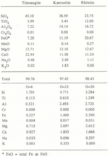
Plagioclase, titanaugite, olivine, kaersutite, rhönite and titanomagnetite are observed under the microscope. Titanaugite is euhedral to subhedral, and shows faint pleochroism of tight purplish-brown. Small grains of olivine occur in some glass shards as microlites, which alter into iddingsite with intense pleochroism, reddish-brown to pale orange. Kaersutite is commonly isolated, relatively coarse-grained, and euhedral to subhedral, and shows distinct pleochroism, brown to light brown. Rhönite occurs with titanaugite and shows strong pleochroism, dark brown to light brown.
5 Chemical Composition
Major element compositions of the glass shards and the crystal fragments from each of the dirt layers from the Yamato Mountains and the Allan Hills regions were analyzed by electron probe microanalyser al the National Institute of Polar Research. The samples are tentatively named the Yamato ash and the Allan ash, respectively.
5.1 Glass shards
Chemical compositions of glass shards in tephra layers may indicate the nature of the rock suite, because they correspond to the liquid compositions of the source magma. Table II lists the average chemical composition of the glass shards in both ashes. The compositions of glass shards in the Yamato ash are relatively uniform, whereas those in the Allan ash are more or less dispersed.
Average Chemical Analyses of Volcanic Glass Shards in the Yamato and the Allan Ashes, and Comparative Analyses of Volcanic Rocks from Bellingshausen and Ross Islands (BI: Basaltic andesite from Bellinghausen Island (Reference BakerBaker 1978), RI: Trachybasalt from Ross Island (Reference Goldich, Treves, Suhr and StucklessGoldich and others 1975), n: number of individual analyses, σ: standard deviation)

As shown in the Na2O + K2O versus SiO2 diagram (Fig.8), the glass shards of the Yamato ash are non-alkaline, whereas those of the Allan ash are alkaline. Selected analyses of the Cenozoic volcanic rocks from Antarctica are also plotted in this diagram. They are classified into two volcanic provinces: (1) the alkaline province of Byrd Land and Victoria Land, and (2) the non-alkaline province of the South Shetland Islands (high-alumina basalt series rich in Na2O) and the South Sandwich Islands (low-alkali tholeiite series) (Reference Katsui and AdieKatsui 1972, Reference González-Ferrán, Vergara and AdieGonzález-Ferrán and Vergara 1972, Reference González-Ferrán and CraddockGonzález-Ferrán 1982). Sub-Antarctic islands such as Heard Island are comprised of alkaline rocks.
SiO2 - Na2O + K2O diagram of analyzed glass shards in the Yamato ash and the Allan ash (Yamato: average composition of glass shards in the Yamato ash. Allan llills: average composition of those in the Allan ash). Shown for comparison are compositions of the Cenozoic volcanic rocks from the South Sandwich Islands (Reference BakerBaker 1978), the South Shetland Islands (Reference González-Ferrán and KatsuiGonzález-Ferrán and Katsui 1970, Reference Weaver, Saunders, Tarney and CraddockWeaver and others 1982), Ross Island (Reference Goldich, Treves, Suhr and StucklessGoldich and others 1975), Pleiades (Reference Kyle and CraddockKyle 1982), Byrd Land (Reference González-Ferrán, Vergara and AdieGonzález-Ferrán and Vergara 1972), and Heard Island (Reference Stephenson and AdieStephenson 1972). The boundaries between alkaline and non-alkaline fields are shown by solid (Reference Macdonald and KatsuraMacdonald and Katsura 1964), chain (Reference MiyashiroMiyashiro 1973) and broken lines (Reference González-Ferrán and CraddockGonzález-Ferrán 1982).

Volcanic rocks of the South Sandwich Islands are characterized by iron enrichment in the middle stage of differentiation of the tholeiitic series. As shown in the Na2O + K2O – total FeO – MgO diagram (Fig.9), the glass shards of the Yamato ash are plotted within the field of the South Sandwich Islands. The glass shards of the Yamato ash have low TiO2 contents and are not markedly enriched in total FeO. Accordingly, it is concluded that the glass shards of the Yamato ash have the distinctive feature of the island arc tholeiite defined by Reference Jakes and GillJakes and Gill (1970). These features are similar to those of the rocks from the South Sandwich Islands. According to Reference Baker and González-FerránBaker (1976), these volcanic islands are dominated by basalt and basaltic andesite of island arc tholeiite composition. Among the South Sandwich Islands, Bellingshausen Island has probably developed in very recent times (Reference BakerBaker 1978). The composition of the less porphyritic basaltic andesite from this island is similar to that of the glass shards of the Yamato ash (Table II).
Na2O + K2O - total FeO - MgO diagram of analyzed glass shards in the Yamato ash and the Allan ash. Shown for comparison are compositions of the Cenozoic volcanic rocks from Antarctica. Legends and references are the same in Figure 8.

On the other hand, the glass shards of the Allan ash have the features of the alkaline rock series. Occurrence of the Cenozoic alkaline volcanic rocks are widely scattered throughout Byrd and Victoria lands. It is unlikely that their compositions show consistent areal variation. Therefore, only a representative rock, a trachybasalt from Ross Island (Reference Goldich, Treves, Suhr and StucklessGoldich and others 1975), which has a similar composition to the glass shards of the Allan ash, is presented in Table II for comparison.
5.2 Crystal fragments
Pyroxene occurs in both ashes, and subcalcic augite in the Yamato ash has a similar composition to that of the South Sandwich Islands (Reference Katsushima, Nishio, Ohmae, Ishikawa and TakahashiKatsushima and others 1984). On the other hand, titanaugite, which is characteristic of alkaline rocks, is found in the Allan ash. In the Allan ash, kaersutite (titan-rich amphibole) and rhönite are observed (Table III). Occurrence of rhönite in basanite has been reported from the McMurdo Volcanic Group (Reference Kyle and PriceKyle and Price 1975). Table IV presents compositions of the mineral fragments in the Yamato and the Allan ashes. For comparison, those of the basaltic andesite from Bellingshausen Island and trachybasalt from Ross Island are also listed.
Chemical Analyses of Crystal Fragments in the Allan Ash
Crystal Fragments in the Yamato and the Allan Ashes and Constituent Minerals in Volcanic Rocks from Bellingshausen and Ross Islands

6 Discussion
As a result of microscopic investigations, the constituent fragments of the dirt layers exposed in the Yamato Mountains and the Allan Hills regions are well-sorted and composed mainly of volcanic glass shards. The chemical compositions of the glass shards are relatively uniform in each layer, but differ markedly between both dirt layers. The mineral assemblages and chemical compositions of the crystal fragments in both layers are compatible with the compositions of the respective glass shards. No foreign fragments derived from the basement rocks can be observed. Therefore, it is suggested that each of the dirt layers represents a single fall unit of tephra which precipitated on the surface of the ice sheet.
Major element chemistry of the glass shards and the composition of the mineral fragments in the dirt layers indicate that the Yamato ash has characteristics of the island arc tholeiite series, whereas the Allan ash has those of the alkaline rock series. These compositional features make it possible to infer that their source regions, with reference to the Quaternary petrographic province, were in and around Antarctica. As described earlier, the Yamato ash is correlated with basaltic andesite from the South Sandwich Islands. Basaltic andesite of the low-alkali tholeiite of island arc type has not been reported around Antarctica except for the South Sandwich Islands. Therefore, it is inferred that the Yamato ash has been derived from a volcano of the South Sandwich Islands, which are about 3000 km away from the Yamato Mountains. This is also supported by the results of grain-size analyses and atmospheric transportation of volcanic glass on the Yamato ash (Reference Katsushima, Nishio, Ohmae, Ishikawa and TakahashiNishio and others 1984). Tholeiitic tephra such as the Yamato ash has not been reported before in Antarctic ice sheets.
On the other hand, alkaline tephras have been described in several other areas of Antarctica. It has been suggested that the tephras found in the Byrd and the Dome C ice cores were derived from Mt Takahe in Byrd Land, as evidenced by their chemical similarity (Reference Kyle and JezekKyle and Jezek 1978, Reference Kyle, Jezek, Mosley-Thompson and ThompsonKyle and others 1981). An example of tephra exposed on the surface of bare ice was reported from Skelton Névé and Kempe Glacier, south Victoria Land by Reference Keys, Anderton and KyleKeys and others (1977), who deduced from grain-size composition, age and other features that the tephra originated from some volcano in the Royal Society Range-Koettlitz Glacier area.
Quaternary alkalic volcanic rocks are widely distributed throughout Byrd and Victoria lands including the McMurdo Sound region. The chemical feature of each volcano is, however, not sufficient to be realized. Therefore, at present it is difficult to specify which volcano yielded the Allan ash. As shown in Figure 5, the coarse grain size of the Allan ash compared with the Yamato ash may indicate the source volcano to be not so distant as that of the latter (Reference Katsushima, Nishio, Ohmae, Ishikawa and TakahashiNishio and others 1984). Accordingly, the Allan ash may have been supplied from some young volcano of the McMurdo Volcanic Group, though further studies are needed before the source volcano is specified.
Acknowledgements
The authors wish to thank members of the 23rd Japanese Antarctic Research Expedition, led by Professor T Hoshiai, National Institute of Polar Research, and also to express their sincere thanks to Professor Y Katsui and Dr S Miyashita of Hokkaido University for critical discussions. They are indebted to Dr K. Yanai and Mr H Kojima for many useful suggestions and permitting us to use the electron probe microanalyser at the National Institute of Polar Research, They also make grateful acknowledgement to Professor A Higashi of Hokkaido University for constant encouragement of this study.


