Introduction
Tunnel valleys and tunnel channels are common within the Quaternary landform and sedimentary record of North American and European ice sheet margins (e.g. Reference WrightWright, 1973; Reference Ehlers and LinkeEhlers and Linke, 1989; Reference Brennand and ShawBrennand and Shaw, 1994; Reference Clayton, Attig, Mickelson, Mickelson and AttigClayton and others, 1999; Reference Jørgensen and SandersenJørgensen and Sandersen, 2006). Tunnel valley networks and sedimentary fills have been identified within Late Ordovician and Late Paleozoic successions (Reference Ghienne and DeynouxGhienne and Deynoux, 1998; Reference Eyles and BroekertEyles and de Broekert, 2001). Tunnel valleys are elongate depressions cut into unconsolidated sediment or bedrock, with typical lengths of 1–100 km, widths of up to 4 km and depths of up to 400 m. Tunnel valleys can either be infilled with sediment or remain unfilled, forming an unfilled channel (O’Cofaigh, 1996; Reference Russell, Arnott and SharpeRussell and others, 2003; Reference Jørgensen and SandersenJørgensen and Sandersen, 2006; Reference Hooke and JenningsHooke and Jennings, 2006). Although tunnel valleys are known to have a subglacial genesis, numerous mechanisms have been proposed to explain their origin. Reference Boulton and HindmarshBoulton and Hindmarsh (1987) proposed that deforming subglacial sediment would flow towards low-pressure zones around conduits, allowing progressive evacuation of subglacial sediment and tunnel valley generation. Reference PiotrowskiPiotrowski (1997) argued that, for glacially-charged aquifers, groundwater flux alone was incapable of instantaneously discharging large meltwater volumes and suggested instead that excess meltwater accumulation at the glacier bed resulted in periodic jökulhlaups, which excavate subglacial sediments to produce tunnel valleys. While large-scale sedimentary structures within some tunnel valley sediment fills indicate time-transgressive formation (Reference PraegPraeg, 2003), fluvial excavation remains one of the most frequently proposed hypotheses to explain the origin and characteristics of tunnel valley systems (e.g. Reference WingfieldWingfield, 1989, Reference Wingfield1990; Reference Ghienne and DeynouxGhienne and Deynoux, 1998; Reference Huuse and Lykke-AndersenHuuse and Lykke-Andersen, 2000; Reference Jørgensen and SandersenJørgensen and Sandersen, 2006; Reference Hooke and JenningsHooke and Jennings, 2006). Tunnel valleys may be modified by numerous processes acting over considerable time spans. Reference BjörnssonBjörnsson (1996) for example has highlighted the role of meltwater in excavating a 300 m deep subglacial trough at Breiðamerkurjökull, Iceland, since the Little Ice Age glacier advance. Tunnel channels, by contrast, are thought to be created by bank-full flow conditions (Reference Brennand and ShawBrennand and Shaw, 1994; Reference Clayton, Attig, Mickelson, Mickelson and AttigClayton and others, 1999; Reference BeaneyBeaney, 2002; Cutler and others, 2002; Reference Sjogren, Fisher, Taylor, Jol and Munro-StasiukSjogren and others, 2002; Reference SmithSmith, 2004; Reference Fisher, Jol and BoudreauFisher and others, 2005). Tunnel channel systems are commonly tens of kilometres in length orientated towards former ice margins directly into proglacial outwash deposits (Reference Clayton, Attig, Mickelson, Mickelson and AttigClayton and others, 1999; Cutler and others, 2002; Reference Kozlowski, Kehew and BirdKozlowski and others, 2005). Many tunnel channels ascend adverse bed topography suggesting that subglacial flow within the channels was pressurized and flowing down a hydraulic gradient controlled by ice-surface elevation (Reference Clayton, Attig, Mickelson, Mickelson and AttigClayton and others, 1999; Reference Johnson, Mickelson and AttigJohnson, 1999; Cutler and others, 2002; Reference Hooke and JenningsHooke and Jennings, 2006; Jørgensen and Sandersen, 2006). In the literature there is considerable debate as to the magnitude and frequency of tunnel channel forming flows. Hypotheses include a sudden or catastrophic origin during glacier outburst floods, or more steady-state conditions associated with progressive headward sapping by deformable bed sediment or seasonal meltwater flows (e.g. Reference MooersMooers, 1989; Reference WrightWright, 1973; Reference Hooke and JenningsHooke and Jennings, 2006). Recent research along the Laurentide Ice Sheet margin suggests periodic glacier outbursts associated with meltwater storage and release behind zones of frozen glacier bed (Reference Clayton, Attig, Mickelson, Mickelson and AttigClayton and others, 1999; Cutler and others, 2002; Reference Hooke and JenningsHooke and Jennings, 2006).
Despite the relative abundance of literature concerning Quaternary tunnel channel genesis, there are no examples of tunnel-channel formation within contemporary glacial systems. This gap has commonly been attributed to a lack of appropriate modern conditions for tunnel channel genesis or the inaccessibility of the subglacial environment (Reference Jørgensen and SandersenJørgensen and Sandersen, 2006). This paper addresses this lacuna and presents the first modern example of tunnel channel formation during a glacier outburst flood or ‘jökulhlaup’ under well-constrained event magnitude, duration and impact.
Aims
The aims of this paper are: (1) to present new evidence of subglacial meltwater erosion and tunnel channel formation during the November 1996 jökulhlaup, Skeiðarárjökull, Iceland; and (2) from this evidence, determine the controls on tunnel channel routing and morphology.
November 1996 Jökulhlaup
A volcanic eruption beneath the Vatnajökull ice cap began on 30 September 1996 (Reference Guðmundsson, Sigmundsson and BjörnssonGuðmundsson and others, 1997). Over the following month, 3.8 km3 of meltwater travelled subglacially into the Grímsvötn subglacial lake until it reached a critical level for drainage (Reference BjörnssonBjörnsson, 2002). The resulting jökulhlaup began in Skeiðará, the most easterly river draining Skeiðarárjökull (Fig. 1), on the morning of 5 November, and reached a peak discharge of 45–53× 103m3 s–1 within 14 hours (Reference BjörnssonBjörnsson, 2002; Reference Snorrason and H.Snorrason and others, 1997, Reference Snorrason, Jónsson, Pálsson, Árnason, Víkingsson, Kaldal, Martini, Baker and Garz’n2002). After its release from Grímsvötn, the jökulhlaup propagated as a high-pressure subglacial flood wave taking 10.5 hours to reach the glacier snout (Reference Roberts, Russell, Tweed and KnudsenRoberts and others, 2000; Reference JóhannessonJóhannesson, 2002; Reference RobertsRoberts, 2005; Reference Flowers, Björnsson, Pálsson and ClarkeFlowers and others, 2004). Floodwater burst from numerous outlets across the entire 23 km wide ice margin (Reference Russell, Knudsen, Smith and RogersRussell and Knudsen, 1999; Reference Roberts, Russell, Tweed and KnudsenRoberts and others, 2000) (Fig. 1). As the jökulhlaup progressed, discharge from the glacier became progressively focussed on major conduit outlets (Reference Roberts, Russell, Tweed and KnudsenRoberts and others, 2000; Reference RobertsRoberts, 2005; Reference Flowers, Björnsson, Pálsson and ClarkeFlowers and others, 2004). Notably, to exit the glacier, floodwaters had to ascend about 300m to the sandur surface (Reference BjörnssonBjörnsson, 1998; Reference RobertsRoberts and others, 2002).
(a) Location of Skeiðarárjökull and Skeiðarársandur within Iceland and in relation to Vatnajökull ice cap. (b) Aerial photograph of waning stage jökulhlaup flows within the Gígjukvísl channel system at 12:00 on 6 November 1996. The location of Sæluhúsakvísl outlet and Sæluhúsavatn lake basin are indicated.
Evidence for large-scale erosion of glacier substrate during the November 1996 jökulhlaup takes the form of copious numbers of intraclasts or rip-ups found in en- and proglacial jökulhlaup deposits (Reference Russell, Knudsen, Maizels and MarrenRussell and Knudsen, 1999; Reference Roberts, Russell, Tweed and KnudsenRoberts and others, 2001; Reference Waller, Russell, Dijk and KnudsenWaller and others, 2001; Reference RussellRussell and others, 2006). The event-based erosion is also seen in published sediment budget calculations for the proglacial area (Reference RobertsRoberts, 2005; Reference RussellRussell and others, 2006). As Grímsvötn subglacial lake acted as a sediment trap for coarse-grained eruption products, the entire solid sediment load of the jökulhlaup downstream of Grímsvötn was solely derived from fluvial erosion of older volcaniclastic, glacial and glaciofluvial sediments (Reference Stefánsdóttir, Gíslason, Arnórsson and ÁrmannssonStefánsdóttir and others, 1999). The estimated total sediment flux during the 1996 jökulhlaup of 1.8×10⁸m3 suggests tunnel channel excavation may have occurred (Reference RobertsRoberts, 2005). Although it is known that subglacial erosion took place during the November 1996 jökulhlaup, no knowledge exists of the spatial distribution and geomorphological expression of erosion. It is notable, however, that between 1996 and 2006, the snout of Skeiðarárjökull thinned by about 100m and retreated by up to 1 km. In particular, ice margin retreat near the Sæluhúsavatn proglacial lake has progressively revealed a subglacial feeder channel to Sæluhúsakvísl, one of the November 1996 jökulhlaup outlets (Figs 1 and 2).
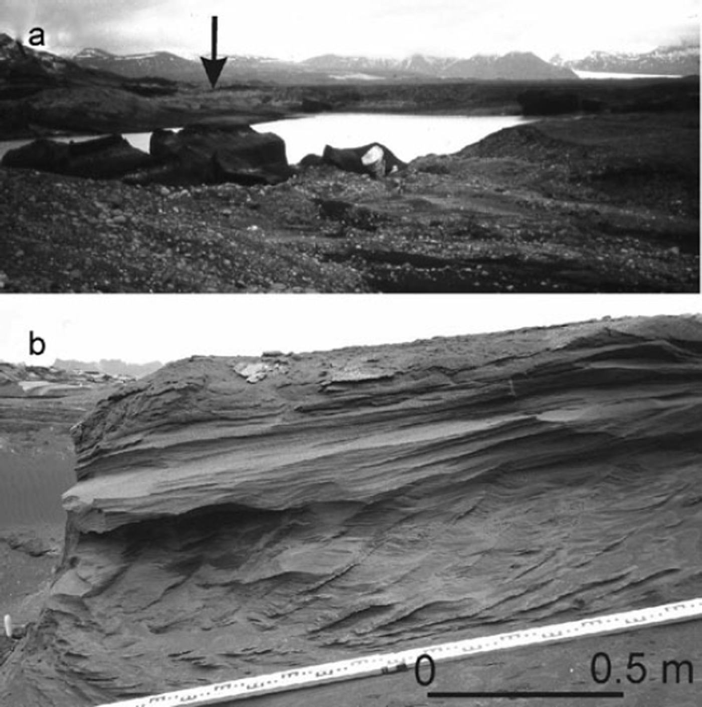
(a) View of the upper Sæluhúsavatn basin in April 1997. Perched delta on the far side of the lake basin and stranded ice blocks indicate higher lake levels prevailed during the jökulhlaup. (b) Climbing ripple sequence exposed within the upper Sæluhúsavatn, approximately 50 m from the position of the 1996 ice margin. Climbing ripples indicate very high sedimentation rates and a flow direction directly away from the glacier margin.
Methods
Fieldwork was undertaken in the Sæluhúsakvísl area of Skeiðarársandur in April 1997, March 2004, July 2005 and April 2006 (Fig. 1). The site was surveyed using Differential Global Positioning System (DGPS) allowing construction of a terrain model of the field area (2331 points) and the mapping of flood wash limits and flood channel morphology (165 points). Within-channel surface grain sizes and bed-forms were noted at regular intervals to allow characterization of grain and form roughness. Channel cross-sectional areas, water surface slopes and roughness were used to reconstruct peak jökulhlaup discharge within the Sæluhúsakvísl tunnel channel and Sæluhúsavatn proglacial lake outflow channels.
Sæluhúsavatn Proglacial Lake Basin
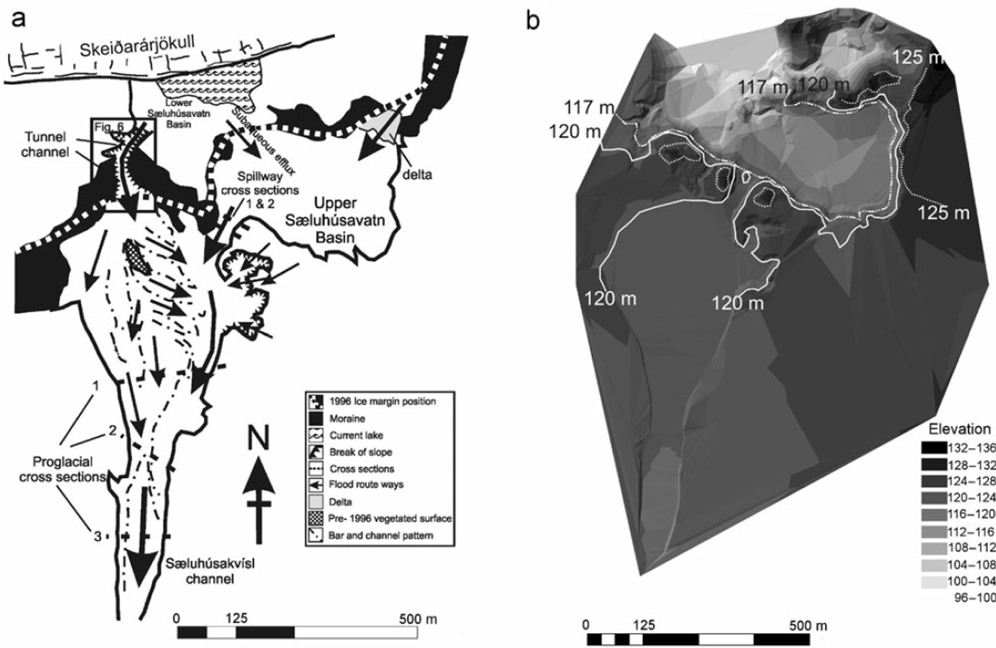
The Sæluhúsavatn upper basin was full of water prior to and immediately following the November 1996 jökulhlaup (Figs 2a, 3 and 4). Stranded ice blocks and silt deposits observed in April 1997 indicated that lake levels rose by several metres during the jökulhlaup (Figs 2a and 3b). A coarse-grained boulder delta deposited on the eastern margin of the lake indicates subaerial jökulhlaup influx to the basin (Figs 2a and 3). Sedimentary infill of the upper Sæluhúsavatn basin includes a 1–2m thick unit of sandy climbing ripples capped by laminated silt (Fig. 2b). Palaeo-current direction is directly away from the former glacier margin (Figs 2b and 4a). Other sedimentary facies include massive sand units containing out-sized cobbles and intraclasts composed of laminated silts. Located within 50m of the 1996 glacier margin, all of these facies are the product of high sedimentation rates and rapid reworking within a lacustrine environment (Reference AllenAllen, 1982a, Reference Allenb; Reference Ashley, Southard and BoothroydAshley and others, 1982). This finding is consistent with subaqueous jökulhlaup efflux into the upper Sæluhúsavatn lake basin (Fig. 4). Jökulhlaup water exited the Sæluhúsavatn basin initially through a number of spillway channels on the western margin of the lake basin, generating a series of cataracts (Figs 3b and 4). Progressive spillway erosion during a later stage of the jökulhlaup accounted for most of the lake outflow.
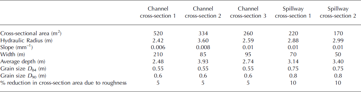
(a) Map of the field area, indicating the location of channel and spillway cross-sections used to reconstruct 1996 jökulhlaup discharge for this system. (b) Elevation model for the field area derived from over 2000 DGPS survey points.

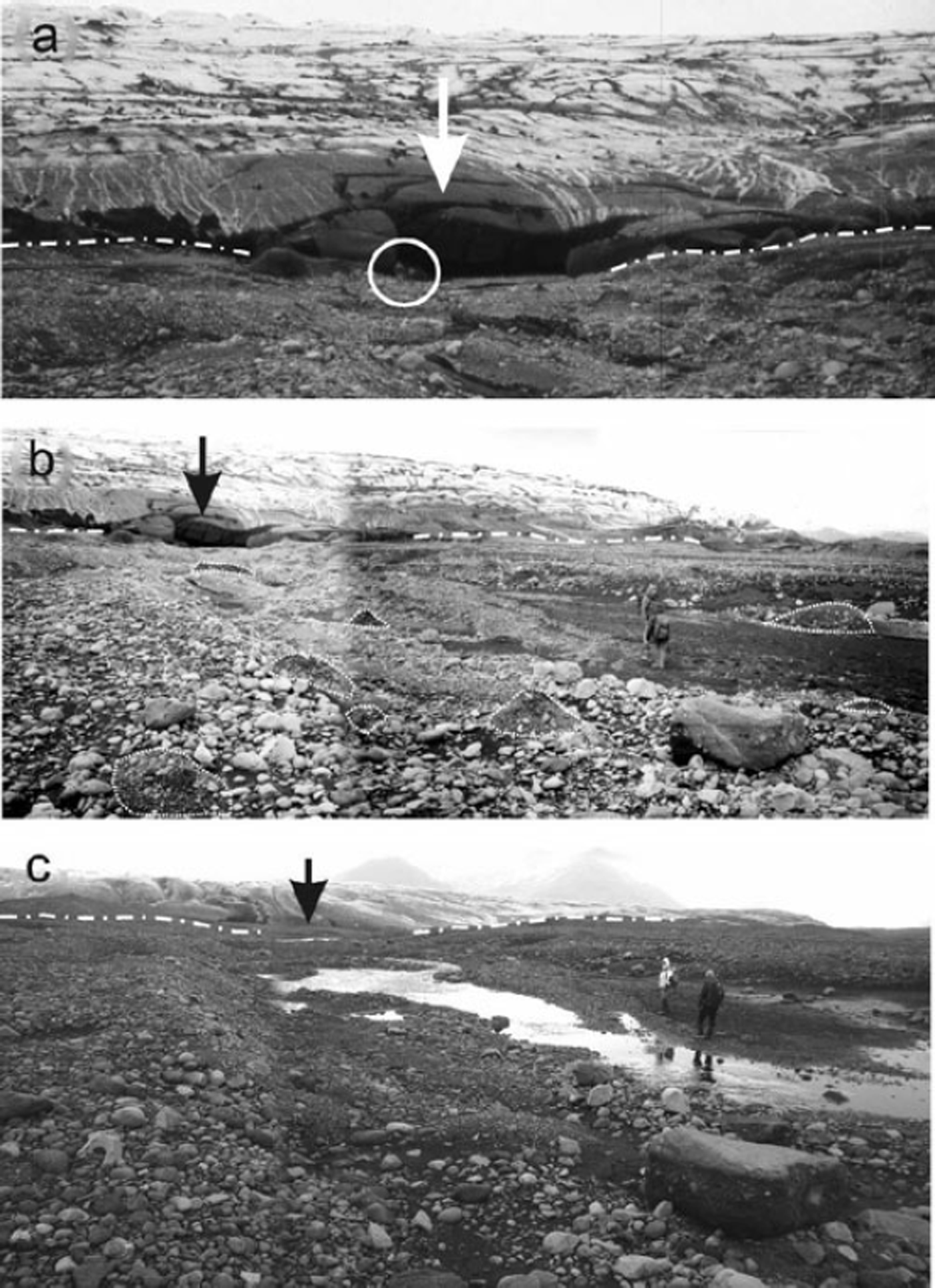
(a) Oblique aerial photograph taken in August 2005 indicates the location of the tunnel channel in relation to the 1996 glacier margin position, proglacial outwash fan and lower Sæluhúsavatn basin. View is from the glacier (in foreground) towards the proglacial area. (b) View from lower Sæluhúsavatn basin up the tunnel channel towards the former ice margin. A smaller channel is truncated by the main tunnel channel.

Reverse-Gradient Channel and Proglacial Outwash Fan
A channel ascends from the lower Sæluhúsavatn basin directly to the head of a distinctive proglacial outwash fan deposited by the 1996 jökulhlaup (Figs 4a and b). Post-jökulhlaup observations reveal a broad, low channel-shaped depression excavated into the surrounding moraine sediment rather than into the overlying ice (Figs 5a–c). The channel bottom ascends 11.5 m over a distance of 160m and has an average reverse gradient of 0.07 (m/m) (Figs 3b, 4a, 4b and 6). The channel bed becomes shallower as it ascends (Fig. 6). Two tributary gullies entering the channel on its western margin represent post-jökulhlaup meltwater reworking during deglaciation of the channel area (Figs 3b, 4 and 6). In order to avoid these post-jökulhlaup channel modification zones, cross-sectional profiles were surveyed between the tributary gullies and the 1996 ice margin (Figs 3b and 6). Bank-full channel cross-sectional areas of between 50 m2 and 90 m2 were derived from channel widths of 25–40m respectively (Fig. 6). The channel base has a relatively smooth appearance when compared to adjacent moraine deposits and the channel margins are characterized by clear breaks of slope in the surrounding moraine sediment (Fig. 5b). With depths restricted to 0.7–2.2 m, the main channel is characteristically wide and shallow, and truncates another shallow channel ascending from the lower Sæluhúsavatn basin (Figs 4b and 6). A figure for the volume of eroded sediment of 14 000m3 was derived by extrapolating surveyed cross-sectional areas (90m2) along the channel length of 160 m. However, a greater channel cross-sectional area (190m2) within the first 100m of the channel as it ascends from the lower Sæluhúsavatn basin suggests that a total of 24 000 m3 of sediment was eroded (Figs 4b and 6).
(a) View of the mouth of the Sæluhúsakvísl outlet in April 1997 illustrating channel incision into moraines on either side (note people for scale). Waning stage erosion dissecting rising stage jökulhlaup deposits, creating a prominent proglacial channel leading towards the viewer. (b) Taken in April 1997 this view shows the central portion of the proglacial outwash fan littered with numerous rip-ups or intraclasts. Waning stage fan incision has exhumed the pre-jökulhlaup vegetated surface near to the people. (c) The same view as in (b) taken in March 2004, illustrating degradation of the intraclasts on an otherwise unaltered surface. Ice margin retreat shows the mouth of the tunnel channel cutting through adjacent moraine ridges.
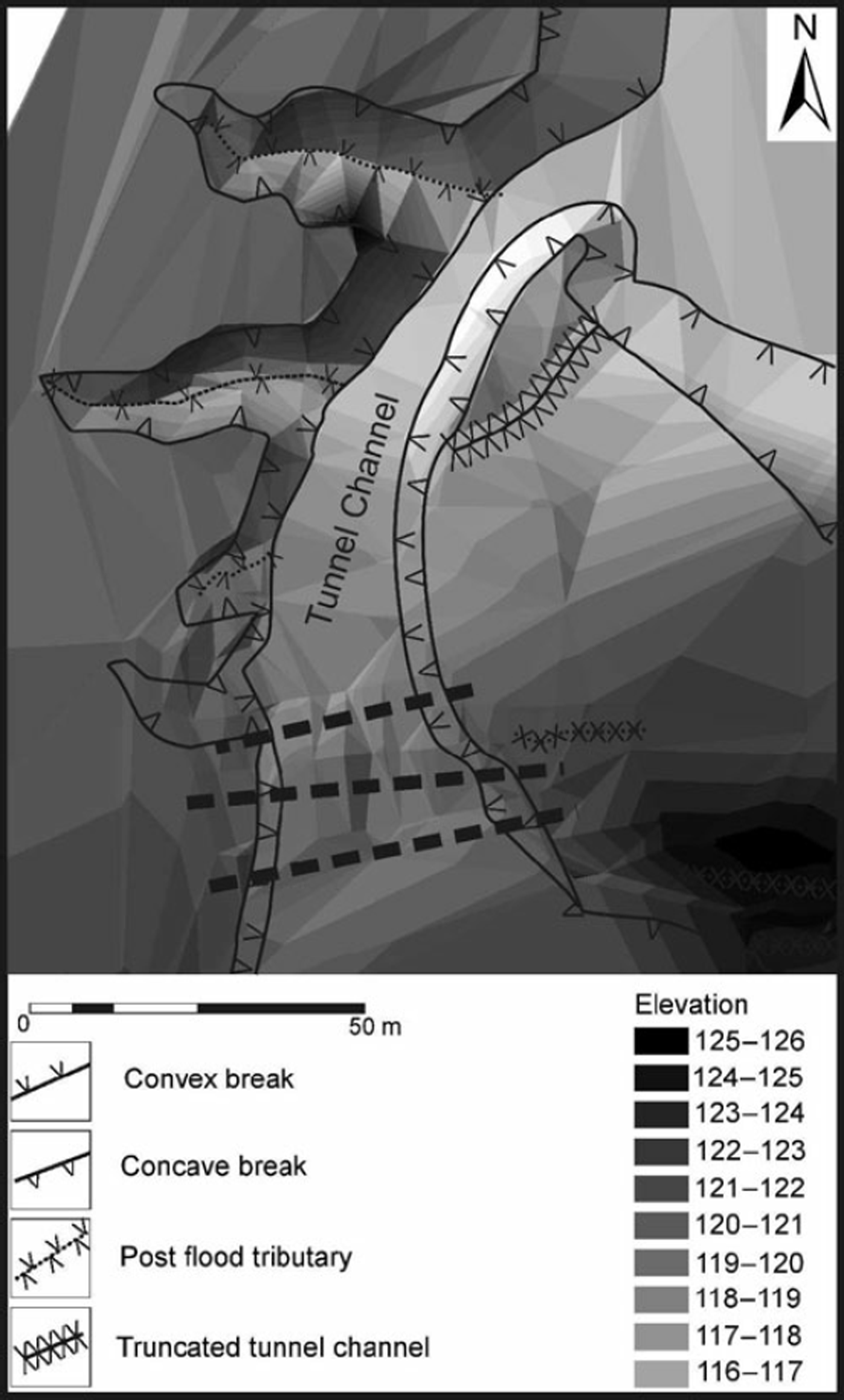
Geomorphological map of the tunnel channel area indicating the location of the cross-sections used to infer flow conditions.
The bar pattern of the proglacial outwash fan indicates rapid flow expansion from the former channel portal, with the upper fan surfaces sloping in a radial fashion away from the channel portal (Figs 3a and 4a). The centre of the fan is incised to a depth of 4m to the pre-jökulhlaup surface (Reference Russell, Knudsen, Martini, Baker and Garz’nRussell and Knudsen, 2002) (Figs 5a and b). Copious numbers of rip-ups or intraclasts composed of glaciofluvial sediment are found on the fan, which also contains sediment of up to boulder size (Figs 5a and b). Relatively few ice block obstacle marks are found on the fan compared with other 1996 jökulhlaup outwash fans (Reference Russell, Knudsen, Smith and RogersRussell and Knudsen, 1999, Reference Russell, Knudsen, Martini, Baker and Garz’n2002; Reference Fay, Martini, Baker and GarzonFay, 2002). The fan has an estimated volume of 70 000m3 based on an average thickness of 2 m and an area of 35 000 m2.
Flow Reconstruction
Peak jökulhlaup discharge was estimated within the Sæluhúsakvísl proglacial channel using four variants of the slope-area technique. Flows were reconstructed at three proglacial channel cross-sections and a further two cross-sections within a spillway channel exiting the Sæluhúsavatn proglacial lake basin (Figs 3a and 6). The proglacial channel cross-sections were inundated solely by jökulhlaup flow
exiting the Sæluhúsavatn proglacial lake and the main tunnel channel portal to the west of Sæluhúsavatn (Fig. 4a).
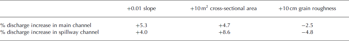
Mean flow velocities for each channel cross-section were calculated using three variants of the standard Manning resistance equation as well as an adaptation of the Keulegan equation (Reference Thompson and CampbellThompson and Campbell, 1979; Russell and others, 1999). The Manning and Keulegan resistance equations required the following input data: (1) the energy gradient or water surface slope; (2) channel hydraulic radius and (3) grain roughness (Reference ChowChow, 1959; Reference HendersonHenderson, 1966; Reference Maizels and GregoryMaizels, 1983). Four methods were used to characterize grain and form roughness in order to identify potential problems of incorporating the channel resistance. Wash limits were located with the help of aerial photographs taken during the jökulhlaup waning stage on 6 November 1996 and surveyed using DGPS. Channel hydraulic radius was calculated from cross-sectional areas and wetted-perimeters derived from surveyed channel cross-sections (Table 1). Channel roughness was characterized by the Darcy-Weisbach friction factor f and Manning’s n. The modified Keulegan equation proposed by Thompson and Campbell
Input data for flow reconstruction

(1979), being the least empirical and least site-specific, was used to calculate the friction factor f in the Darcy-Weisbach equation (Reference Church, Wolcott and MaizelsChurch and others, 1990). The Darcy-Weisbach equation was used to obtain mean velocity values:

where s is the slope, d is the flow depth (m), g is the acceleration due to gravity (9.81ms–2) and f is the friction factor calculated using Reference Thompson and CampbellThompson and Campbell’s 1979 equation:

where R is the hydraulic radius and k s is the size of the roughness elements equal to 4.5 times the boulder size Di . In this case, we calculated k s as the proportion of the flow depth d occupied by flow resistance elements ΔA:
The proportion of the flow depth occupied by flow resistance elements was estimated visually. A single f value was calculated for each cross-section. Calculated f values were converted to Manning’s n using an equation presented by Reference RichardsRichards (1982):

Manning’s n values were calculated from grain size characteristics using the Manning-Limerinos and Manning-Strickler equations (Equations 5 and 6), which required estimates of the D 84 and D 90 percentiles of the grain size distribution (Reference Maizels and GregoryMaizels, 1983; Ryder and Church, 1986; Reference Russell, G.F. and McCabeRussell, 1994):

where d is flow depth and D 84 and D 90 are the 84th and 90th percentile grain-size values, respectively. D 84 and D 90 percentiles were derived for each cross-section from estimates of surface grain sizes. However, n values calculated from grain-size distributions were compared with those derived solely from water surface slope and the hydraulic radius using Jarrett’s equation (Reference JarrettJarrett, 1984):
where R is the hydraulic radius (m) and S is the energy slope. Mean flow velocities were derived for each proglacial channel cross-section using each of the four variants of the slope-area technique presented above. Peak flood discharges were derived by multiplying mean flow velocities by channel cross-sectional areas.
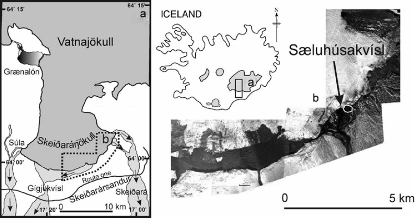
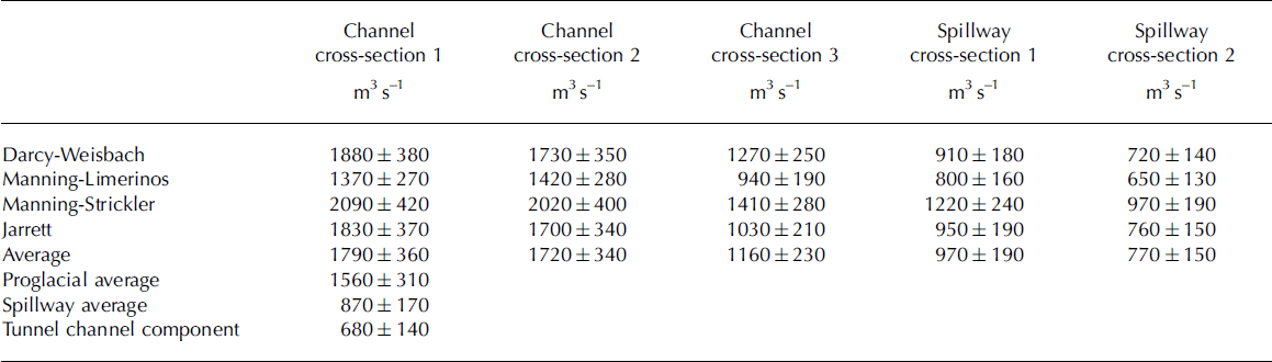
Average peak jökulhlaup discharge for the Sæluhúsakvísl proglacial channel was reconstructed as 1560±310m3 s–1 (Table 2). Average peak discharge from the main spillway channel exiting the Sæluhúsavatn was reconstructed as 870 ±170 m3 s–1 (Table 2). There is good correspondence of discharge values derived from the various techniques (Table 2). Sensitivity of peak discharge estimates to changes in water surface slope, channel cross-sectional area and grain roughness are presented in Table 3. Slope-area discharge estimates are sensitive to channel cross-sectional area as discharge is the product of resistance-based velocities and cross-sectional areas (Table 3). Although variation of water surface slope and grain roughness has a significant impact on discharge, these parameters can be constrained reliably. The estimated error for each discharge measurement using the slope-area technique is estimated to be ±20%. The difference in average reconstructed discharge between the proglacial and spillway channels (690m3 s–1) exceeds the likely errors at each site.
Discharge estimates
Sensitivity of discharge reconstruction techniques to changes in input parameters

If peak discharge within the proglacial and spillway channels was synchronous, then peak flow exiting the tunnel channel would be 680 m3 s–1 (Table 2). Dominance of proglacial bars and channels emanating from the tunnel channel portal, however, suggest that flows from the tunnel channel peaked later than those exiting the Sæluhúsavatn basin (Figs 3a and 4a). The peak discharge of 680 m3 s–1 for the tunnel channel should therefore be regarded as a minimum figure.
Average peak flow velocities within the tunnel channel of 8–14ms–1 are derived by dividing peak discharge, calculated from the proglacial hydraulic reconstructions, by the surveyed channel cross-sectional area. This assumes that the tunnel channel was subject to bank-full conditions and that there was no tunnel roof expansion. Observations of the outlet in April 1997 indicate that the conduit was mainly sediment-walled, showing little upward expansion into the glacier (Fig. 5a).
Discussion
The case for a tunnel channel feeding the Sæluhúsakvísl proglacial outwash fan is supported by: (1) the clear association of the freshly cut channel ascending from the lower Sæluhúsavatn basin and the proglacial outwash fan (Figs 3, 4 and 6); (2) the lack of any major meltwater outlet or proglacial outwash fan in the Sæluhúsakvísl area prior to the jökulhlaup as indicated by oblique aerial photos taken in August 1996; (3) repeated ground and aerial observations since 1996 that do not indicate any major meltwater flow from the 1996 ice margin towards the upper Sæluhúsavatn basin capable of generating the channel system (Figs 3a and 4a) and (4) observations of the outlet channel cutting through adjacent moraine deposits in April 1997 (Figs 5a and b). The presence of numerous rip-up clasts on the proglacial fan surface confirms that major subglacial excavation took place at this location during the 1996 jökulhlaup (Figs 5b and c). Estimated volumes of sediment eroded from the tunnel channel account for 20 to 34% of the volume of the proglacial outwash fan, highlighting the importance of subglacial tunnel channel erosion as a source of sediment to the jökulhlaup at this site. Many of the outwash fans draining the eastern side of Skeiðarárjökull are heavily incised by waning stage flows implying rapid and marked reductions in sediment supply (Reference Russell, Knudsen, Martini, Baker and Garz’nRussell and Knudsen, 2002; Reference RussellRussell and others, 2006).
Although there is evidence of subaqueous jökulhlaup efflux into the upper Sæluhúsavatn basin at an elevation of 110 m, a substantial discharge ascended the flanks of the lower basin through the tunnel channel to exit at an elevation of 120m (Fig. 3). Aided by subaerial and the aforementioned subaqueous jökulhlaup influx, the level of the Sæluhúsavatn rose from 117m to 125 m allowing the formation of a delta graded to a lake level of 125 m (Fig. 2a). The temporarily raised proglacial lake levels acted as a hydraulic dam deflecting subglacial jökulhlaup flow up the western flank of the upper basin to exit the glacier margin at an elevation of 120 m (Figs 3, 4 and 6). Within-flood changes in hydraulic conditions can therefore be seen to have a significant impact on meltwater flow routing and tunnel channel trajectory. In addition, the presence of a smaller truncated tunnel channel ascending from the upper Sæluhúsavatn basin suggests progressive channel evolution, possibly from an anastomosing to a single channel (cf. Reference Brennand, Russell, Sharpe and KnightBrennand and others, 2006).
The Sæluhúsakvísl tunnel channel and proglacial outwash fan described in this paper show many similarities to those described from Quaternary ice marginal zones (e.g. Reference Clayton, Attig, Mickelson, Mickelson and AttigClayton and others, 1999; Cutler and others, 2002; Reference Kozlowski, Kehew and BirdKozlowski and others, 2005; Reference Jørgensen and SandersenJørgensen and Sandersen, 2006). Similarities between the Sæluhúsakvísl and Quaternary tunnel channel systems include: up-glacier slopes; associated outwash fans displaying rapid downstream fining and apex incision; dissection of end moraines and a characteristic ‘box’ shape (Reference Clayton, Attig, Mickelson, Mickelson and AttigClayton and others, 1999; Cutler and others, 2002; Reference Kozlowski, Kehew and BirdKozlowski and others, 2005). Reference Clayton, Attig, Mickelson, Mickelson and AttigClayton and others (1999) and Cutler and others (2002) attributed channels cut into outwash fan apexes in Wisconsin to erosion during the waning stage of a tunnel-channel flood. Absence of ice-block obstacle marks or kettle-holes on proglacial outwash fans led Cutler and others (2002) to conclude that tunnel discharge had been relatively modest or that they had been covered by deposits of later lower magnitude flows. Interestingly, 1996 jökulhlaup flows within the Sæluhúsakvísl channel were noted to have a modest number of ice blocks when compared to adjacent outlets. Flood flow within sediment-walled tunnel channels will not result in as much ice removal as en- or supraglacial conduits which are subject to vigorous erosion processes during jökulhlaups (Reference Roberts, Russell, Tweed and KnudsenRoberts and others, 2001; Reference RobertsRoberts, 2005).
Our modern analogue has demonstrated a close relationship between tunnel channel erosion and proglacial outwash deposition. The data presented clearly demonstrate the ability of meltwater, under these conditions, to erode under appropriate local hydraulic gradients and in the presence of erodible glacier substrate. Tunnel channel formation in Iceland takes place beneath temperate glacier ice in the absence of permafrost. The November 1996 jökulhlaup had a sufficiently rapid onset to induce water pressures high enough to force large volumes of water to ascend from a heavily over-deepened glacier basin. Many Quaternary tunnel channels ascend to ice margins from over-deepened basins (Reference Clayton, Attig, Mickelson, Mickelson and AttigClayton and others, 1999; Cutler and others, 2002; Reference Jørgensen and SandersenJørgensen and Sandersen, 2006). Over-deepened basins may encourage tunnel channel formation as ascending subglacial meltwater will seek the most efficient route through highly erodible and complex glacier substrate. The presence of an over-deepened basin may also help retain meltwater within subglacial lakes (e.g. Reference ShoemakerShoemaker, 1992; Reference AlleyAlley and others, 2006; Reference DomackDomack and others, 2006) thereby providing a source of water for release during tunnel channel forming bursts.
Conclusions and Wider Implications
For the first time at a contemporary glacial margin, we have demonstrated that glacier outburst floods are capable of generating tunnel channels. In our Icelandic example, tunnel channel routing is controlled by subglacial topography and rapid changes in subglacial and proglacial hydraulic gradients during the 1996 jökulhlaup. One cannot explain the location or trajectory of the tunnel channel discussed in this paper without recourse to transient ice-marginal hydraulic conditions during the 1996 jökulhlaup. This paper demonstrates the need for greater attention to be paid to the interaction of proglacial lakes as a control on subglacial meltwater flow routing (see also Reference BrennandBrennand, 2000). We suggest that the presence of proglacial lakes will increase the variability of geomorphologic response and sedimentary signature of glacier outburst floods over distances as little as a few hundred metres. Our study highlights the importance of meltwater outbursts as agents of tunnel channel formation and provides a valuable modern analogue for a process which has until now only been inferred from the Quaternary record. Further research is required to determine the origin of the lower Sæluhúsavatn basin which, being of composite origin, can be classified as a tunnel valley.
Acknowledgements
We acknowledge fieldwork grants from Earthwatch and the UK Natural Environment Research Council (GR3/10960, AJR). We thank Ragnar Frank Kristjánsson for supporting our research within Skaftafell National Park and the July 2005 and April 2006 Earthwatch volunteers for field assistance. This manuscript was greatly improved by reviews from L. Clayton and T. Brennand as well as editorial comments by Gudfinna Aðalgeirsdóttir.