

Introduction
The disastrous outbursts of glacier-dammed lakes represent a significant hazard in many of the world’s mountain ranges (Reference Clague and MathewsClague and Mathews, 1973; Reference Ding and LiuDing and Liu, 1992; Reference Richardson and ReynoldsRichardson and Reynolds, 2000; Reference BjörnssonBjörnsson, 2003; Reference Huss, Bauder, Werder, Funk and HockHuss and others, 2007a). The sudden drainage of meltwater impounded behind an ice dam, also known as a jökulhlaup, can increase proglacial discharge by more than one order of magnitude over periods of 1 day or less (Reference LiuLiu, 1992; Reference Hewitt and LiuHewitt and Liu, 2010), and the processes triggering these events are still not fully understood (Reference Sugiyama, Bauder, Huss, Riesen and FunkSugiyama and others, 2008; Reference Werder, Bauder, Funk and KeusenWerder and others, 2010). Consequently, predicting the timing of ice-dammed lake outbursts is difficult, and early warning measures are important to reduce the risk to local human settlements. The impact of glacier floods in mountainous regions is known to be particularly pronounced as the proglacial streams often lead into densely populated areas. However, the hazard assessment of glacier lakes at remote and high-elevation sites of the Himalaya, Karakoram and Tien Shan is difficult due to restricted field site accessibility (e.g. Reference HewittHewitt, 1982).
Yarkant river drains an area of 50 248 km2 in the Chinese Karakoram and ranks as number one in terms of flood frequency and damage in Xinjiang. Its glacial outburst floods, with peak discharges of up to 6000 m3 s–1, originate from a remote ice-dammed glacier lake at 4750ma.s.l. in the Shaksgam valley, ~560 km upstream of the floodplains (Reference ZhangZhang, 1992; Reference Hewitt and LiuHewitt and Liu, 2010; Fig. 1). The hazardous lake is impounded behind the snout of Kyagar glacier which blocks the riverbed of Shaksgam valley. In the past the lake volume was ~230 106m3 (Reference FengFeng, 1991).
Situation of (a) Yarkant river in the Tarim basin, (b) Shaksgam valley and (c) Kyagar glacier tongue with the location of the observation station and the indicated camera view directions of the automatic camera.

The Yarkant river floods may be divided into three types, those produced by (1) meltwater, (2) rainstorm and (3) glacial lake outbursts (Reference ZhangZhang, 1992). Meltwater floods occur in summer, when the ablation is strong due to high temperatures. The peak flow of such a flood is not very large, but its total volume is considerable due to its long duration. Statistics over the last 50 years show that peak flow of meltwater floods at Kaqun hydrographical station exceeded 2000 m3 s–1 only once (Reference FengFeng, 1991). In the Yarkant basin, ~50% of the annual precipitation occurs in June to August (monsoon), coinciding with the ablation period. Thus, a rainstorm flood often concurs with a meltwater flood, thereby amplifying its intensity. Between 1954 and 2007, 13 floods were classified as rainstorm floods; one of these exceeded a peak flow of 2000 m3 s–1 at Kaqun station (Reference FengFeng, 1991; Reference Hewitt and LiuHewitt and Liu, 2010).
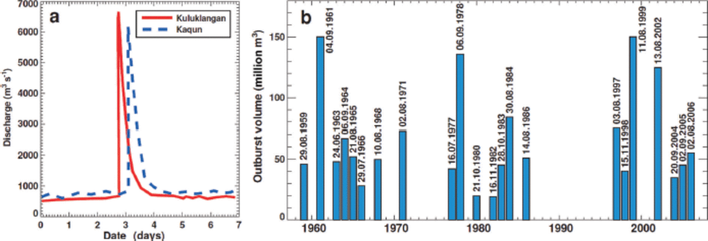
In the Tarim basin, most catastrophic floods result from the abrupt drainage of Kyagar lake. Most of these floods occur during late summer to early autumn and often are unexpected. Their peak discharges are generally 2-4.5 times greater than meltwater floods, but the flood volumes are smaller. The volumes of most glacial lake outburst floods (GLOFs) were in the range 40-60 x 106m3. Between 1954 and 2012, 22 floods were classified as GLOFs (Reference ZhangZhang, 1992; Fig. 2b); two of them exceeded a peak discharge of 6000 m3 s–1 at Kaqun (Fig. 2a), and five more events are characterized by a peak discharge of >4000 m3 s–1, causing severe damage in the floodplain of Yarkant river (e.g. Reference HewittHewitt, 1982). Due to the high peak discharges originating from GLOFs of the ice-dammed lake at Kyagar glacier, Yarkant river exhibits the highest peak flooding in Xinjiang Uyghur Autonomous Region (Reference FengFeng, 1991). The spontaneous floods pose a threat to more than a million inhabitants on the floodplains of Yarkant river.
(a) Observed flood hydrographs of the Kyagar glacier lake outburst of 1961 at two gauging stations at 410 km (Kuluklangan) and 525 km (Kaqun) from the lake. (b) Reconstructed glacier flood volumes at Kaqun station since the 1960s with the dates of the floods. Data redrawn after Reference ZhangZhang (1992) and Reference Chen, Xu, Chen, Li and LiuChen and others (2010). Date format is day.month.year.
In 2009, the floods along Yarkant river became the subject of a Sino-Swiss cooperation project based on a Memorandum of Understanding between the Chinese Ministry of Water Resources and the Swiss Federal Department of the Environment, Transport, Energy and Communications. The project aims to jointly explore ways to improve risk management for coping with the challenges of climate change and to share experiences and know-how between experts in the field. The activities aim at improving the management of GLOFs on Yarkant river and at long-term monitoring of the glaciers causing these floods. The activities are structured into three phases: (1) establishment of an early warning system (EWS) for GLOFs, (2) risk management in the flood areas, and (3) climate change monitoring and analysis.
In this paper, we discuss the behavior of Kyagar glacier and its relation to GLOFs. We explain the concept of a new EWS, combining satellite remote sensing and three automatic terrestrial observation stations, which allows the local authorities to act promptly whenever the ice-dammed Kyagar lake produces an outburst flood. We also present a joint analysis of a comprehensive set of remote-sensing data from various sources (Reference Heid and KäabHeid and Kääb, 2012; Reference Gardelle, Berthier, Arnaud and KääbGardelle and others, 2013) that documents the changes in the geometry of Kyagar glacier, as well as variations in its ice flow speed, since 2000. Furthermore, a series of 2 years of synthetic aperture radar (SAR) datasets, acquired at 11 day intervals or multiples thereof, provides an exceptional dataset for analyzing short-term changes in ice flow speed as well as the mass balance of the ice dam as a result of mass gain due to ice flux and mass loss by melt or calving. We draw an integrative picture of recent changes in Kyagar glacier and their connection to the lake formation and drainage, and provide an outlook on the future hazard potential.
Study Site
Kyagar glacier is a large polythermal valley glacier situated in the Chinese Karakoram mountains in the southwest of Xinjiang Uygur Autonomous Region. The glacier has a total area of ~100 km2 and consists of three separate accumulation basins that join into a 10km long and 1.5 km wide glacier tongue with an average surface slope of 2-38. The glacier snout is located at 4750ma.s.l. The accumulation area of the glacier extends upwards to almost 8000 m a.s.l. A low annual precipitation of ~200 mm (Reference ZhangZhang, 1992) causes a high firn line at ~5400 m a.s.l. In the Shaksgam valley there are a considerable number of surging glaciers (e.g. Reference CoplandCopland and others, 2011; Reference Gardelle, Berthier, Arnaud and KääbGardelle and others, 2013). For example, a surge of north Gasherbrum glacier (~50 km downstream of Kyagar glacier; Fig. 1b) in 2007 was documented in detail by Reference Mayer, Fowler, Lambrecht and ScharrerMayer and others (2011). The glacier terminus advanced by several hundred meters into the Shaksgam valley, nearly blocking the passage of Keleqin river.
The north-flowing Kyagar glacier completely blocks the east-west-oriented upper Shaksgam valley and forms a 50-150 m high and 1.5 km wide ice dam (Fig. 1c). The lake impounded behind this ice dam was documented for the first time by Reference MasonMason (1928) and is known to fill up and drain repeatedly (Reference ZhangZhang, 1992). The hydrological catchment of Kyagar lake has an approximate size of 350 km2 and comprises the source region of Keleqin river, the largest tributary of Yarkant river. Prominent terrestrial marks on the slopes of the Kyagar lake basin indicate ancient shorelines (see Reference SturmSturm, 1986, for a description of their formation) and, hence, provide evidence for the historical maximum elevation of the lake level, with a lake volume corresponding to -230 x 106m3. Kyagar lake thus used to be one of the largest ice-dammed lakes in the world, with documented regular drainages and down-valley impacts (Reference Hewitt and LiuHewitt and Liu, 2010). Outburst events of Kyagar lake are most probably characterized by the process of subglacial drainage (see, e.g., Reference ZhangZhang, 1992).
Data Sources
A Sino-Swiss expedition reached the basin of Kyagar lake in September 2012. An observation station was installed close to the ice dam to take daily photographic images from different viewing angles (Fig. 3) and to record the local meteorological conditions (air temperature, solid and liquid precipitation, humidity, global radiation). In addition, GPS ground control points were acquired, and glaciological observations at the ice dam were carried out. However, because of the remoteness of the study site and the inaccessibility of the glacier surface due to up to 40 m high ice pinnacles, we base our study mainly on remote-sensing data.
(a) The empty basin on Kyagar lake, with its ice dam beyond (automatic camera image, 24 May 2013). (b) Empty lake basin with Keleqin river in the valley bottom and Kyagar glacier tongue on the right (automatic camera image, 24 May 2013).

In order to evaluate how the thickness of the ice dam relates to the dynamics of Kyagar glacier and to assess the hazard potential of the impounded lake, we use several sets of remote-sensing data. Using digital elevation models (DEMs) based on satellite imagery, we estimate recent ice thickness changes and quantify variations in glacier surface flow velocity.
To generate an up-to-date reference DEM of the ice dam of Kyagar lake, four scenes of WorldView-2 stereo imagery were acquired on 25 June 2011 for manual photogrammetric stereo-mapping of Kyagar glacier tongue and the lake basin. The DEM has a spatial resolution of 4 m. Another DEM of the same area was established based on two Ikonos 1 m resolution optical images dating from 20 March and 2 June 2002. The Ikonos 2002 stereo scene was triangulated using the same ground control points as used for the 2011 WorldView-2 stereo imagery. The resulting mapping uncertainty between the 2002 and the 2011 imagery is ~±0.5 m in easting and northing which was confirmed by in situ GPS measurements in the vicinity of the glacier. The elevation difference between the 2002 and the 2011 DEM indicates an uncertainty of ±1 m over stable terrain. For the glacier, a higher uncertainty of ~±2.8 m due to high surface roughness and water-filled pools is estimated.
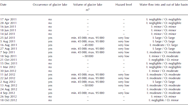
Very high-resolution SAR data of the TerraSAR-X satellites were used to identify the hazard potential of Kyagar lake. Based on SAR backscatter, lake surfaces for every image could be delineated. Lake volumes were calculated using lake shorelines and the detailed reference DEM of the lake basin established in 2011. Hazard levels were estimated as a result of the lake size. Furthermore, the flow regime of Keleqin river (i.e. lake basin water inflow and outflow) was estimated qualitatively using SAR backscatter. The TerraSAR-X sensors provide detailed information at 1 m pixel spacing. These satellite data were continuously analyzed with a repeat-pass period of at least 11 days (Table 1).
Satellite data used to identify the GLOF hazard level during 2011 and 2012. All data are from SAR backscatter TerraSAR-X Sensor (except 25 June 2011 from WorldView-2 and 18 June 2011 from COSMO-SkyMed). I = water inflow into the lake basin, O = water outflow from the lake basin
In order to analyze the state of Kyagar lake over recent decades, we compiled a total of 65 optical satellite images from various sensors acquired between 1972 and 2011. This imagery allows the calculation of historical glacier lake areas and impounded volumes as well as the visualization of changes in Kyagar glacier. No significant phases of advance and retreat of the glacier terminus are evident, which might explain why Kyagar is not listed as a surge-type glacier by Reference CoplandCopland and others (2011). However, because glacier flow at the terminus is perpendicular to a steep rock wall (Fig. 1c), it seems reasonable to expect that glacier changes will be expressed as thickening and thinning rather than advance and retreat.
Information about surface elevation changes for hundreds of glaciers in the Himalaya–Karakoram region is provided by Reference Gardelle, Berthier, Arnaud and KääbGardelle and others (2013). For Kyagar glacier, they compared glacier surfaces mapped by the Shuttle Radar Topography Mission (SRTM) in February 2000 with a DEM derived from Satellite Pour l’Observation de la Terre (SPOT) imagery dating from October 2010. The accuracy of retrieved 10year elevation changes is assumed to be within a few meters, although data quality is slightly inferior in the accumulation area and some mapping errors are evident (Reference Gardelle, Berthier, Arnaud and KääbGardelle and others, 2013).
Based on feature-tracking in Landsat imagery, Reference Heid and KäabHeid and Kääb (2012) derived longitudinal annual flow speed profiles for several hundred glaciers in different mountain ranges for every year in the period 2000-11, allowing temporal trends in ice flow to be analyzed. Changes in center-line surface ice flow speed in the ablation area of Kyagar glacier are available from an updated dataset (personal communication from Reference Heid and KäabT. Heid, 2012). Reference Heid and KäabHeid and Kääb (2012) compared annual Landsat images acquired between mid-July and early September and estimated the uncertainty in the flow speed measurements as ±5-6ma–1. In order to directly compare displacement rates in individual years with observation period lengths varying between about 300 and 400 days, all flow speeds were normalized to 365 days by assuming constant velocity over the year.
The 21 TerraSAR-X scenes acquired over Kyagar glacier (Table 1) were used for the SAR offset tracking analysis to determine glacier velocities. Their temporal sampling is excellent during the summer and fall periods, when many acquisitions were programmed for monitoring the glacial lake. During winter and spring the intervals are significantly longer. The TerraSAR-X data are at high spatial resolution (<3m), enabling high SAR offset tracking accuracies to be achieved.
We estimate distributed ice thickness of Kyagar glacier tongue by inverting assumed ice volume fluxes based on the principles of ice flow mechanics using the approach by Reference Huss and FarinottiHuss and Farinotti (2012). Calculated center-line thicknesses are between 100 m close to the ice dam, which agrees with the general morphology of the Shaksgam valley, and ~300 m at 8 km from the terminus. Uncertainties in inferred thicknesses are considerable, however, as little is known about typical glacier thicknesses in the Karakoram.
Methods
Concept of early warning and monitoring
Based on the hazard assessment of Kyagar lake and newly gained knowledge about the dynamics of Kyagar glacier, an EWS for GLOFs was implemented. Because the lake is situated in a remote area, our EWS utilized a combination of satellite remote-sensing and automatic terrestrial measurements. Based on the DEM of the empty lake basin from 2011 and periodically acquired SAR images, the evolving morphology of both lake and glacier could be observed within a time interval of 11 days (see Table 1). The current lake volume was then calculated, and the hazard level determined and transmitted to the Chinese decision-makers at the Xinjiang Kashgar Hydrographic and Water Resources Survey Bureau and other authorities (Fig. 4).
Concept of the early warning system, combining satellite remote sensing and automatic terrestrial observation stations.

In addition to remote-sensing techniques, terrestrial solar-powered observation stations were installed directly at the lake and further downstream along Keleqin and Yarkant rivers at Cha Hekou and Kuluklangan (Fig. 4). Based on camera images acquired by the Kyagar observation station, the lake volume can be estimated using terrestrial markers on the mountain flanks. Hence, it is possible to directly identify the hazard potential on photographs taken by the automatic camera. Another fully automatic observation station is located at Cha Hekou, ~200 km downstream of Kyagar glacier lake (Fig. 1 and 4). There, radar sensors continuously log the water level of Keleqin river, and pictures of its riverbed are taken. Several times a day, all data are automatically transmitted via satellite link to a specific data portal. GLOFs typically show an obvious peak with rapidly rising and declining discharge. If water levels reach a certain threshold, an automatically generated alarm signal is immediately sent to mobile phones of the Chinese authorities. Thus, emergency actions can be initiated. Once the alarm signal is transmitted from the observation station, ~22 hours remain before the flood reaches the settlement area in the floodplains.
The EWS was completed with a third automatic terrestrial observation station at Kuluklangan (Fig. 4), close to the settlement area. This location covers almost the entire catchment area of Yarkant river and is therefore a suitable place for recording meltwater, rainfall and GLOFs.
SAR offset tracking methodology
The flow velocity of Kyagar glacier was estimated using SAR offset tracking. This methodology can be used to estimate both the line-of-sight (LOS) displacement and the azimuth displacement between the two acquisition dates (Reference Fatland and LingleFatland and Lingle, 2002; Reference Strozzi, Luckman, Murray, Wegmüller and WernerStrozzi and others, 2002; Reference Joughin, Abdalati and FahnestockJoughin and others, 2004). The displacements were converted from pixel offsets to meters. For the conversion from the LOS and azimuth components to easting and northing it is assumed that the movement is in the horizontal plane. For the flat lower part of the glacier this assumption does not significantly affect the quality of the result, however. In offset tracking, pixel offsets are determined between the two SAR images. These offsets can be determined to a small fraction of a pixel (e.g. 0.05 pixel in ice-free terrain) depending also on factors such as the method or the patch size used, etc. For glacier velocity mapping, the accuracy of the pixel offsets translates to sensitivities in LOS and azimuth direction. In the case of TerraSAR-X, for example, 0.05 pixel (of the original single-look complex) translates to ~0.1 m in both azimuth and ground range (assuming horizontal displacement).
Our strategy was to apply the offset tracking for all pairs of close neighbors separated by at most three acquisitions. This ensures that the intervals are generally short and that there is some redundancy in the displacement observations for each interval. The longest intervals are for the wintertime (October to June) when no (or few) scenes were ordered. Including these winter pairs is relevant, however, for obtaining a complete displacement time series. Based on these pairs a time series was then derived using a singular value decomposition method. Some smoothing of the time-series solution was achieved by introducing constraints on the change in velocity as described by Reference Schmidt and BürgmannSchmidt and Burgmann (2003). Apart from the time series, a quality value was determined to quantify how well the derived time series and the individual observations correspond.
Calculation of ice volume flux
Based on the spatially distributed surface flow velocities from SAR offset tracking, we evaluated ice volume fluxes into the region of the ice dam in order to establish a flux budget of the ice dam of Kyagar glacier. We considered a flux gate (Fig. 5 and, further below, 7) that represents a glacier cross section perpendicular to flow and is located ~2 km upstream of the glacier terminus. The cross-sectional distribution of annual surface flow speed us was obtained from the total displacement between the first and the last image used for feature-tracking normalized with 365 days.
High-resolution DEMs of the ice dam in 2002 and 2011 and calculated maximum potential lake volume. The block diagrams show only the westernmost section of Kyagar lake.

Vertical flow velocity profiles u(z) across the glacier were calculated using (e.g. Reference Huss, Sugiyama, Bauder and FunkHuss and others 2007b)
where h is the local ice thickness calculated for Kyagar glacier after Reference Huss and FarinottiHuss and Farinotti (2012), ub is the basal flow speed and n = 3 is the exponent of Glen’s flow law (Reference GlenGlen, 1955). As a first-order approximation, ub was estimated as 50% of surface flow. Varying this ratio between 20% and 80% had minimal impact (±10%) on the calculated volume flux. Applying Eqn (1), the ice volume flux into the ice dam in 2011/12 was able to be calculated, allowing an assessment of the present balance between ablation (melt, calving) and compensation by ice flow.
Results
Retreat of Kyagar glacier tongue since 2002
The two high-resolution DEMs covering the glacier terminus showed a considerable mass loss of the ice-dam area (3.5 km2) between 2002 and 2011 (Fig. 5). In total, 18.5x10⁶m3a-1 were lost, which corresponds to an average thinning of 48m or a thinning rate of 5.3 ma–1. The height of the ice dam, estimated from the elevation difference between the dam surface and the lake-basin floor, was reduced by more than one-third. No significant changes in glacier area were observed, however, over the last decade. Whereas the down-valley glacier terminus remained almost stable, an enlargement of the lake basin and a recession of the ice dam by 200-420 m due to calving were evident on the eastern side of the glacier tongue. Despite the major ice surface lowering, the glacier was in contact with the opposite mountain flank, where the ice was protected by a debris layer. The upper Shaksgam valley was thus still completely blocked by Kyagar glacier. The observed thinning of the ice dam had a strong impact on the maximum potential water volume of the glacier-dammed lake. Whereas in 2002 a lake volume of 153x106m3 could potentially have been reached until overtopping of the ice dam, the potential lake volume decreased to only 22 x 106m3 in 2011 due to lowering of the glacier tongue (Fig. 5). The relation between ice-dam height and maximum lake volume is thus strongly nonlinear. Flood records indicate a lake outburst volume of roughly 120 x 106m3 in 2002 (Fig. 2b). This is also consistent with the lake volume of 95 x 106 m3 which was calculated using a Landsat image from 9 August 2002 and the DEM of the empty lake basin. No outburst floods were recorded in 2011 and 2012, however, and the fortnightly monitoring of the lake using TerraSAR-X images showed that in these years only a very small lake with a volume of ~0.1 x10⁶m3 existed from July to mid-September (Table 1).
Danger of floods in the past and at present
Based on historical observations of 22 floods from Kyagar lake since 1960 (Fig. 2; Reference ZhangZhang, 1992; Reference Chen, Xu, Chen, Li and LiuChen and others, 2010), an empirical relation between lake volume and peak discharge was established. We used the Reference Clague and MathewsClague and Mathews (1973) formula
which calculates peak discharge Q (m3 s–1) from lake volume V (in 106m3) and where a and b are empirical parameters. We assume Vcorresponds to the observed flood volume (Fig. 2b). The best fit to the data was found with a = 160 and b = 2/3. The exponent b was thus consistent with theoretical considerations of outburst events of glacier-dammed lakes (Reference Ng and BjörnssonNg and Björnsson, 2003), but the parameter a was larger than in other applications of the same empirical formula (e.g. Clague and Matthews, 1973; Reference Huss, Bauder, Werder, Funk and HockHuss and others, 2007a), indicating that the floods from Kyagar glacier are more violent. This might be related to the limited width of the ice dam, and the small ice thickness, both of which favor a fast enlargement of drainage channels. Application of the empirical equation to the maximum potential lake volume at present (22x106m3) indicates that peak discharges of ~1300m3 s–1 could be reached. Comparing these values to historical records (Fig. 2) shows that the present hazard potential has decreased considerably over recent years and currently is relatively small. However, the possible damage in the Yarkant river floodplain caused by such an event remains uncertain. Further investigations based on field-verified flood modeling results (i.e. flood hazard indication map) will yield more information about the affected damage potential in the floodplains.
Recent dynamical changes in Kyagar glacier
Although observations show a substantial decline of the maximum potential lake volume and significant mass loss of the ice dam, projecting the future changes of Kyagar lake requires that the entire glacier system is taken into account. This is especially important as many glaciers in the Karakoram are known to be subject to periodic surges (Reference HewittHewitt, 2005; Reference Barrand and MurrayBarrand and Murray, 2006; Reference Mayer, Fowler, Lambrecht and ScharrerMayer and others, 2011; Reference Gardelle, Berthier and ArnaudGardelle and others, 2012).
Comparison of the two DEMs from 2000 and 2010 covering the entire glacier surface reveals that Kyagar glacier most likely is a surge-type glacier, as has already been indicated by Reference Gardelle, Berthier, Arnaud and KääbGardelle and others (2013). The substantial surface lowering in the terminus region shown by our high-resolution DEMs of 2002 and 2011 (Fig. 5) is also captured by the large-scale DEMs provided by Reference Gardelle, Berthier, Arnaud and KääbGardelle and others (2013). The two independent datasets agree on the magnitude of the ice loss (Fig. 6a). However, the large-scale DEMs indicate insignificant surface elevation changes on the glacier tongue 5 km behind Kyagar lake, and even an increase in ice thickness above 5050 m a.s.l. (Fig. 6a and b). The region with maximum positive elevation changes (+25 m in 10 years) is below the equilibrium-line altitude. The surface elevation increase is thus clearly driven by ice flow dynamics and not directly by higher snow accumulation. Elevation changes are also positive for the accumulation area (~+10m). The observed elevation change pattern (Fig. 6b) is typical for a surge-type glacier in quiescent phase (see Reference Gardelle, Berthier, Arnaud and KääbGardelle and others, 2013). The maximum of the surge activity occurred before acquisition of the first DEM, and the ice reservoir is building up.
(a) Glacier surface elevation derived from SRTM and SPOT data on a longitudinal profile of Kyagar glacier according to Reference Gardelle, Berthier, Arnaud and KääbGardelle and others (2013). Bedrock elevation is calculated after Reference Huss and FarinottiHuss and Farinotti (2012). (b) Surface elevation change between 2000 and 2010. (c) Observed ice flow speeds for annual periods in 1999/2000, 2004/05 and 2010/11 along the central flowline of Kyagar glacier according to Reference Heid and KäabHeid and Kääb (2012), and SAR offset-tracking derived flow speeds for 2011/12.
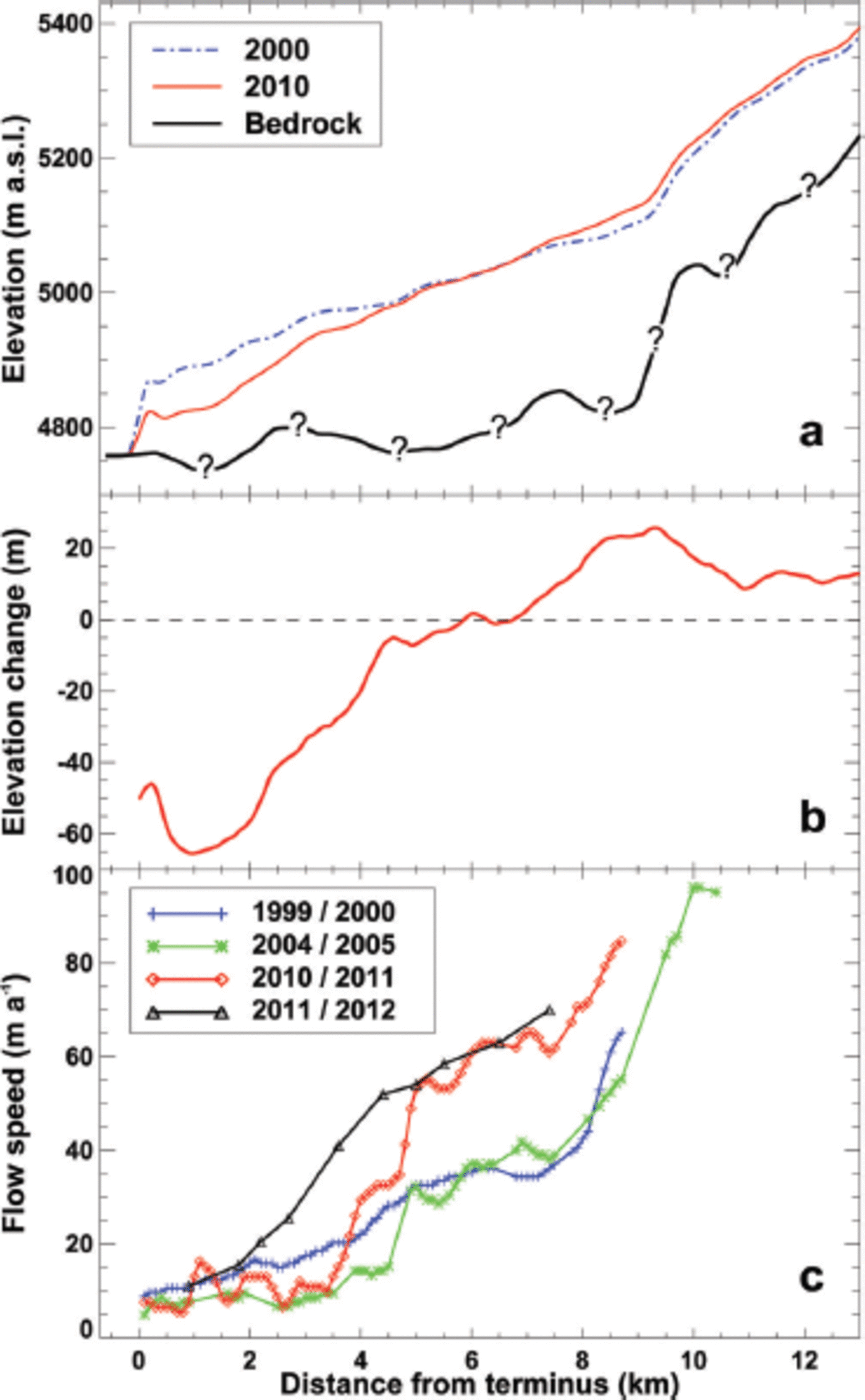
Changes in ice-flow speed are well suited for recognizing and projecting glacier changes driven by surge activity (e.g. Reference Quincey, Braun, Glasser, Bishop, Hewitt and LuckmanQuincey and others, 2011) although variations in flow can also occur unrelated to glacier surges (e.g. Reference Scherler and StreckerScherler and Strecker, 2012). Annual surface velocity data along the central flowline of Kyagar glacier by Reference Heid and KäabHeid and Kääb (2012) allow an analysis of changes in the dynamics of the glacier tongue over the last decade (Fig. 6c). At 10 km behind the terminus the ice of Kyagar glacier flows at a velocity of -100ma–1, whereas the glacier is almost stagnant in the region of the ice dam (5-15 m a–1). Between 1999/2000 and 2004/05, flow speeds declined everywhere along the glacier. Since 2005, however, a significant acceleration has been observed 5-9 km behind the glacier terminus (Fig. 6c). Surface velocity has almost doubled in a period of a few years in this region, whereas ice flow did not show significant changes at lower elevations. The observed temporal and spatial patterns of ice flow speeds coincide with measured surface elevation changes (Fig. 6): flow speed increases are greatest in regions with a balanced or positive surface elevation change.
The joint analysis of the datasets by Reference Gardelle, Berthier, Arnaud and KääbGardelle and others (2013), Heid and Kääb (2012) and our results from SAR offset tracking (2011/12) covering the period 2000-12 indicate that Kyagar glacier currently has a balanced overall mass budget, and that a new surge has been initiated in the upper reaches of the ablation area. If the surge front reached the ice dam, the dam would thicken and, by raising the maximum outburst level of the lake, increase the GLOF hazard potential. Monitoring ice surface velocity and elevation is thus required in order to observe potentially dangerous developments of Kyagar lake.
The evaluation of the TerraSAR-X scenes using SAR offset tracking provided ice surface displacement with great temporal and spatial resolution between early summer 2011 and fall 2012, thus allowing the interpretation of the most recent ice-dynamical changes in Kyagar glacier. The total displacement between the first and last images acquired is shown in Figure 7. Maximum surface velocities correspond to the values of Reference Heid and KäabHeid and Kääb (2012), and a downward propagation of the accelerating region between 2011 and 2012 is noted (Fig. 6c). The highest flow speeds were found below the confluence of the two main branches of Kyagar glacier. A clear seasonal variation in ice flow speed, i.e. acceleration in summer and slowdown in winter, is observed (inset of Fig. 7) along the entire ablation area.
Total displacement of Kyagar glacier during the 550 days between 17 April 2011 and 18 October 2012. The color indicates displacement, and the small arrows the direction of flow. Time series of cumulative displacement are shown for three selected points a, b and c in the inset.

This indicates that basal sliding is an important component of the flow of Kyagar glacier. The deceleration during the winter is probably related to reduced meltwater input to the glacier bed. The observation that transversal variations in ice flow speed are small (Fig. 7) equally supports the hypothesis that ice deformation is a less important component of flow of Kyagar glacier tongue than basal sliding. By integrating cross-sectional mean annual flow speeds at the flux gate of the ice dam (Fig. 5) and making simple assumptions on basal sliding, we calculated an ice volume flux of 2.5 ± 1.0 x 10⁶m3a–1 entering the terminus region of the glacier using Eqn (1). The confidence interval around this result integrates conservative uncertainty estimates for ice thickness at the flux gate (±40%), for SAR-derived annual flow speeds (±10%) and for the effect of an unknown percentage of basal sliding on total flux (±10%).
Comparison of two image pairs covering an 11 day period around the end of July/beginning of August 2011 and 2012, respectively, revealed a significant acceleration of the glacier between 2011 and 2012 (Fig. 8). Maximum flow speeds increased from ~0.20 m d–1 to 0.32 m d–1. Moreover, the region with fast glacier flow seemed to be extended in 2012, and center-line flow speeds at the flux gate of the ice dam (Fig. 5) were two to three times higher than in 2011. Although both periods considered had the same length and were in the same season, it is unclear whether flow speed changes can be interpreted as an increase in glacier surge activity. The fast flow in 2012 might be at least partly due to the strongly enhanced snow- and ice-melt water yields observed in Xinjiang during that summer. Continued observations are required to obtain a better understanding of short-term processes affecting the ice flow dynamics of Kyagar glacier tongue.
Glacier surface ice velocity (m d–1) for two 1 1 day periods in July/August 2011 (left) and 2012 (right).

Discussion
The combined analysis of different DEMs and datasets on the ice flow speed of Kyagar glacier has shown that the formation of the ice-dammed lake and its floods are probably closely linked to the glacier’s surge activity. The substantial reduction of the maximum potential glacier lake volume and the absence of an outburst in 2011 and 2012 are in line with a quiescent phase of the glacier with relatively small ice flow speeds and strong mass losses at the glacier terminus. However, observations indicate the onset of a new glacier surge with a downward propagation of a more active flow regime and an uplift of the glacier surface (Fig. 6). It is yet unclear whether these mass gains in the upper ablation zone can compensate for the strong melt of the ice dam occurring during the last decade.
We are not aware of any documentation of past surges of Kyagar glacier. Previous expeditions to Kyagar lake (Reference MasonMason, 1928; Reference ZhangZhang, 1992), however, have reported advance phases of the glacier while they were visiting. The clustering of large flood volumes in the late 1990s and early 2000s (Fig. 2b) might indicate that the maximum of the last surge – and thus a thick ice dam in front of Kyagar lake - occurred -10-15 years ago. The records of flood volumes at Kaqun station (Reference ZhangZhang, 1992) are probably not complete and accurate enough to quantitatively interpret the frequency of GLOF occurrence. However, over the last five decades three clusters of large GLOFs have been found: around the 1960s, the 1980s and the 2000s (Fig. 2b). This might lead us to speculate whether there is a relationship between this pattern and the phases of advance and retreat of Kyagar glacier resulting in large lake volumes during glacier advance periods related to surges, and no destructive floods appearing in the records during periods of mass loss of the ice dam.
In order to assess the probability of a future regrowth of the ice dam due to a glacier surge, we evaluated the current balance between melt and ice volume supply by flow into the terminus region of the glacier, which we defined as the glacier ice below the flux gate presently covering an area of 3.5 km2 (Fig. 5). We calculated the annual ice volume lost by ablation by subtracting ice volume flux through the flux gate given by the velocities estimated using SAR offset tracking of 2011/12 from observed mean annual ice volume change in 2002-11. Currently, only ~12% of ablation in the terminus region of Kyagar glacier is compensated by ice flow (Fig. 9a), highlighting the strong imbalance of the ice dam at present. Note that (1) ice flux only refers to 2011/12, whereas annual volume change is a mean over the last decade, and (2) a considerable volume of ablation in the terminus region of Kyagar glacier seems to be due to calving of icebergs into the lake. By analyzing changes in the calving front we estimate that 30-50% of volume loss in 2002-11 can be attributed to this process.
(a) Present volume balance of the ice dam (see Fig. 5) based on observed volume change 2002–11 and cross-sectional ice flux given by SAR offset tracking (see Fig. 7). The ablation is inferred from volume change and ice flux. (b) Combined scenarios for an increase in ice thickness (relative to 2011) and multiples of surface ice flow speed (relative to 2012; horizontal axis) at the flux gate that are necessary for compensating surface melt in the region of the ice dam (see Fig. 5) by ice flux.
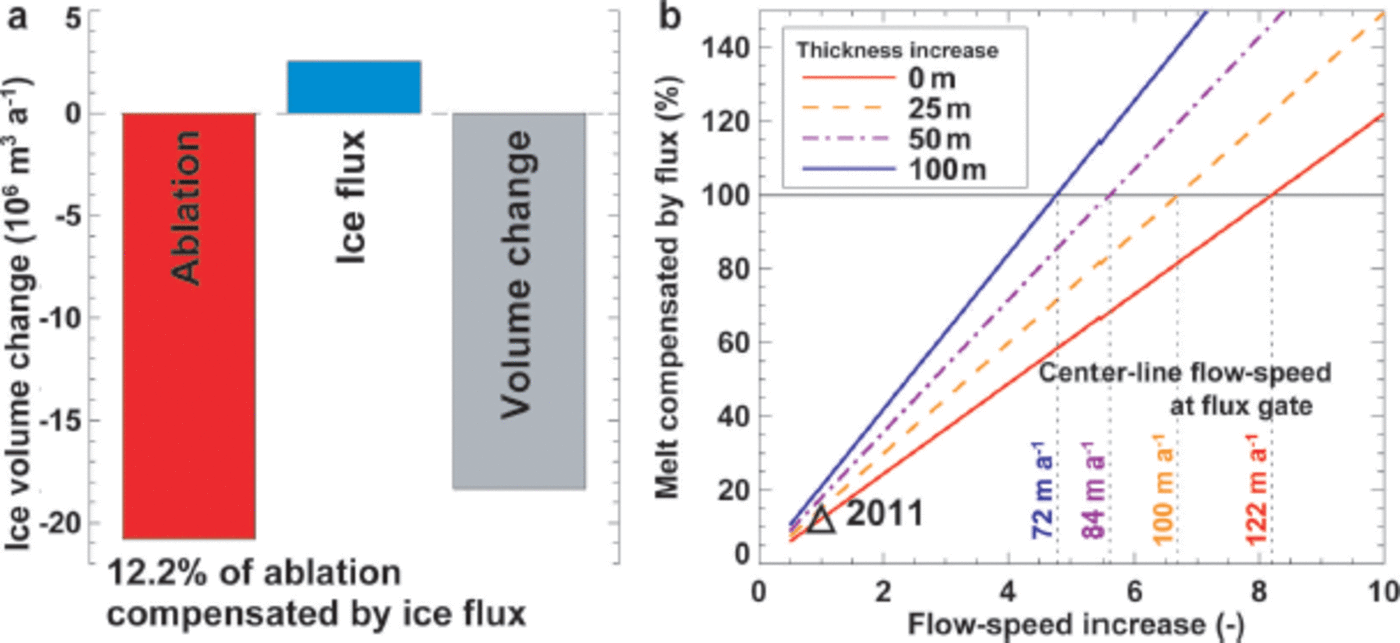
Assuming the rate of melting and calving (i.e. ablation) on the ice dam of Kyagar glacier remains constant in time, we investigated simple scenarios of changes in ice flux required to yield a balance between ablation and ice supply by ice flow for the ice dam. This was achieved by calculating volume flux with Eqn (1) using changed flow speeds and ice thicknesses at the flux gate. With the same ice thickness at the flux gate as today an eightfold increase in ice flow speed (i.e. ~120ma–1) would be required in order to compensate for the volume losses by melting and calving, and to stop the lowering of the ice dam (Fig. 9b). Only an even higher acceleration of the glacier would promote rebuilding of the ice dam, and consequently the possibility of the formation of a new hazardous glacier lake. An increase in flow speed is normally associated with a thickness gain of the glacier (Fig. 6). For this reason, we also performed calculations with uniform thickness increases of between 25 and 100 m at the flux gate. Even with a thickening of 100m which roughly corresponds to the maximum height of the historical lateral moraines, surface flow speed would need to increase by a factor of four to >60ma–1 at the flux gate in order to compensate for the present ablation in the terminus region (Fig. 9b). These experiments allow a rapid estimation of the probability of a regrowth of the ice dam based on a very few measurements which are easy to achieve using remote-sensing techniques. Furthermore, the analysis showed that current ablation rates of the ice dam were sufficiently high that they could be compensated only by a strong acceleration of the glacier, which still lies far beyond the flow speed changes observed over recent years. Only through a substantial thickening of the ablation zone, that might be supported by sustained positive mass balances of Kyagar glacier, does an increase in glacier flow resulting in a considerable readvance of the glacier seem possible.
Conclusions and Outlook
Glacial lakes are linked to complex glaciological processes, are formed in remote mountain areas and are affected by climate change. In addition, the damage potential in the floodplains and the vulnerability of society are constantly growing, as a result of the increasing population density combined with larger economic assets in risk zones. All these aspects need to be considered in cooperation with the decision-makers. The Sino-Swiss project is based on strong collaboration and experience exchange between experts from both countries aimed at implementing practicable, cost-efficient and sustainable measures.
In remote areas where no structural measures (e.g. drainage tunnels) are practicable, the implementation of an automatic EWS based on satellite remote sensing and terrestrial observation stations has proved to be efficient and could significantly reduce damage in the floodplain area. The automatic observation stations are fully operational. Both water level fluctuations and EWS functionality are monitored continuously.
During the last decade, the height of the Kyagar glacier ice dam decreased by more than one-third due to strong melt and reduced ice inflow. Hence, the potential maximal glacial lake volumes declined by 80% to ~22 x 106m3 in 2011. Consequently, the GLOF hazard potential has been significantly reduced. The magnitude and frequency of future GLOFs are directly linked to glacier dynamics, in particular to surge activity. This and previous studies on ice flow velocities and surface elevation changes indicate a surge-type glacier in a currently quiescent phase with a balanced overall mass budget. When a new surge front reaches the glacier tongue this could lead to a thickening of the ice dam and hence an increase in the GLOF hazard potential in the near future. Experiences with the hazard assessment of Kyagar lake show that the remote monitoring of glacier flow characteristics, mass-balance estimations and a solid understanding of the glacier dynamics are necessary elements for implementing an efficient EWS.
Acknowledgements
The project is supported by a cooperation between the Swiss Agency for Development and Cooperation (SDC) and the Federal Office for the Environment (FOEN). On the Chinese side, local authorities, including the Xinjiang Department of Water Resources, the Xinjiang Kashgar Hydrographic and Water Resources Survey Bureau and the Kashgar Management Bureau of Tarim River Basin, support the project. J. Gardelle of LGGE (Laboratoire de Glaciologie et Géophysique de l’Environnement), Grenoble, France, is acknowledged for sharing her elevation change data for Kyagar glacier, and we thank T. Heid of the University of Oslo, Norway, for providing flow speed data since 2000. S. Braun-Clarke proofread the English. Comments by an anonymous reviewer, J. Clague and the scientific editor, F. Ng, were helpful for finalizing the paper.


