

Introduction
Changes in glacier geometry and subglacial water drainage not only influence glacier dynamics (e.g. Reference Bindschadler, Harrison, Raymond and CrossonBindschadler and others, 1977; Reference Iken and TrufferIken and Truffer, 1997) but also have implications for glacier mass balance and runoff from glaciated regions (e.g. Reference Barrett and CollinsBarrett and Collins, 1997; Reference BraunBraun and others, 2000). While much of the knowledge of the geometry and hydrology of glaciers and their changes with time has been gained from in situ measurements (e.g. Reference Clarke and BlakeClarke and Blake, 1991; Reference FountainFountain, 1993; Reference Nienow, Sharp and WillisNienow and others, 1998), such field-based studies are difficult, time-consuming and expensive. As an alternative, remote sensing and terrain analysis techniques provide the basic data for assessing the geometry of glaciers and for studies of glacier hydrology. Changes in glacier thickness and extent have been determined from the analysis of sequential digital elevation models (DEMs) of the surface topography in combination with a DEM of the bed topography (e.g. Reference Fountain and VaughnFountain and Vaughn, 1995; Reference Hagen, Etzelmüller and NuttallHagen and others, 2000; Reference RippinRippin and others, 2003). In addition, by calculating hydraulic potential surfaces across glacier beds, these DEMs have been used to identify the likely patterns of subglacial water flow and their changes with time (e.g. Reference SharpSharp and others, 1993; Reference Fountain and VaughnFountain and Vaughn, 1995; Reference Flowers and ClarkeFlowers and Clarke, 1999; Reference Hagen, Etzelmüller and NuttallHagen and others, 2000; Reference RippinRippin and others, 2003).
In this paper, we use DEMs of the bed and surface of Unteraargletscher, Switzerland, to investigate changes in glacier geometry and subglacial drainage system structure between 1927 and 1997. To substantiate the reconstructed patterns of basal water flow, we compare the theoretical drainage network for 1997 with observations of the locations of active moulins and the hydraulic connection status of boreholes drilled to the glacier bed.
Study Area
Unteraargletscher is a temperate valley glacier, situated in the Bernese Alps, Switzerland, emanating from the confluence of two main tributaries, Finsteraar- and Lauteraar-gletscher (Fig. 1). Since 1924, systematic measurements of changes in surface elevation and displacement have been carried out on Unteraargletscher every year (Reference FlotronFlotron, 1924–2003). More recently, the main emphasis of research activities has been extensive investigations of glacier hydrology and dynamics (e.g. Reference Iken, Röthlisberger, Flotron and HaeberliIken and others, 1983; Reference Funk and RäthlisbergerFunk and Röthlisberger, 1989; Reference Gudmundsson, Iken and FunkGudmundsson and others, 1997, Reference Gudmundsson, Bauder, Lüthi, Fischer and Funk1999, Reference Gudmundsson, Bassi, Vonmoos, Bauder, Fischer and Funk2000; Reference Fischer, Porter, Schuler, Evans and GudmundssonFischer and others, 2001; Reference Schuler and FischerSchuler and others, 2002, Reference Schuler, Fischer and Gudmundsson2004; Reference Schuler, Fischer, Sterr, Hock and GudmundssonSchuler and Fischer, 2003).
Map of Unteraargletscher and its two main tributaries, Finsteraar- and Lauteraargletscher. The dashed line indicates the location of cross-sectional profiles shown in Figure 4 (see text for details). Shading on glacier represents debris-covered ice. Inset shows the study area in the Bernese Alps.
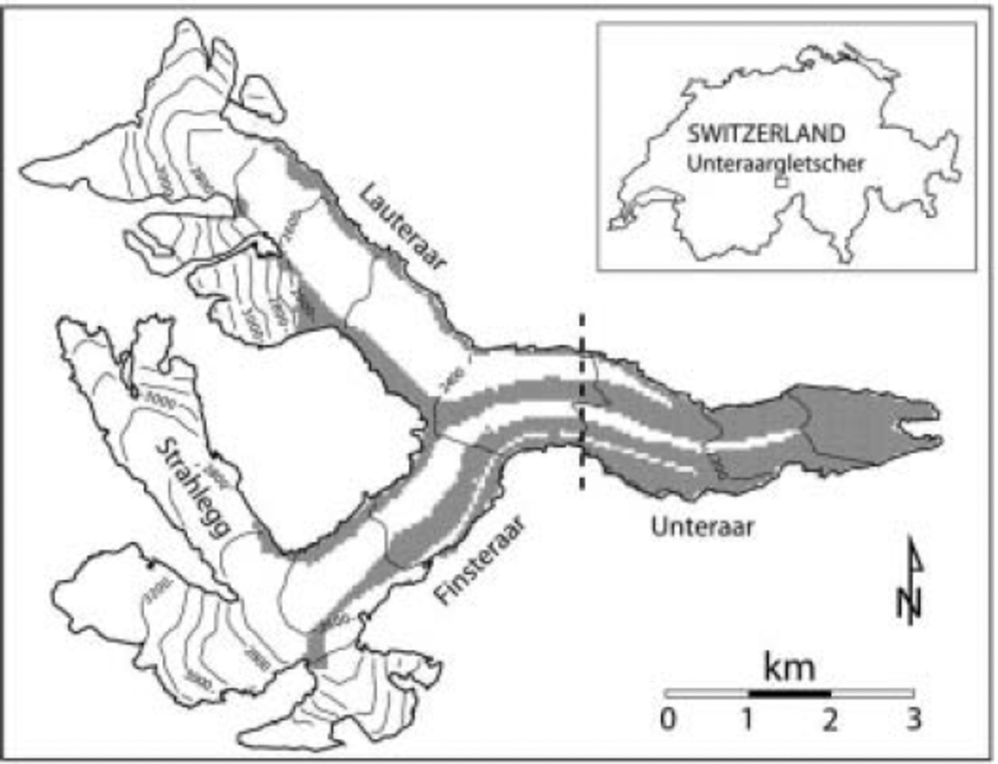
Unteraargletscher is ∼6 km long, 1 km wide and has a mean surface slope of approximately 4˚. A prominent feature of the glacier is the large ice-cored medial moraine which is formed by the convergence of the lateral moraines of Lauteraar- and Finsteraargletscher. The debris cover of the moraine is typically 5–15cm thick. At the confluence zone the medial moraine is 10–20m high and ∼100m wide. With distance down-glacier it grows to a maximum height of 50 m and width of 300m before it gradually spreads out and merges with the marginal morainic debris in the terminus region. Smaller medial moraines on the southern side of Unteraargletscher are the result of Finsteraargletscher being fed by Strahlegggletscher and a number of smaller tributaries. In contrast, there are no tributaries that feed large amounts of ice to Lauteraargletscher, so the northern side of Unteraargletscher is nearly debris-free (Fig. 1).
Methodology
Reference ShreveShreve (1972) suggested that water moves in and under glaciers in response to hydraulic potential gradients. The total hydraulic potential at the base of a glacier, ϕ b, is the sum of pressure potential and elevation potential
![]() is the subglacial water pressure, ρ
w and ρ
i are the densities of water and ice respectively, g is the acceleration due to gravity, z
b is the elevation of the glacier bed, z
s is the elevation of the ice surface and k is a factor between 0 and 1 representing the range of the subglacial water pressure from atmospheric pressure (k = 0) to full ice-overburden pressure (k = 1).
is the subglacial water pressure, ρ
w and ρ
i are the densities of water and ice respectively, g is the acceleration due to gravity, z
b is the elevation of the glacier bed, z
s is the elevation of the ice surface and k is a factor between 0 and 1 representing the range of the subglacial water pressure from atmospheric pressure (k = 0) to full ice-overburden pressure (k = 1).
![]()
Application of Equation (1) requires knowledge of the basal and surface topography of the glacier. The bed topography of Unteraargletscher is available from Reference Funk, Gudmundsson and HermannFunk and others (1994) and Reference Bauder, Funk and GudmundssonBauder and others (2003), who determined the thickness of the ice by radio-echo sounding. To date, 12 DEMs of the glacier surface, either digitized from topographic maps or derived photogrammetrically from aerial photographs, are available from Reference BauderBauder (2001) and include the years 1927, 1947, 1961 and 1997. The DEMs of the bed and surface were embedded within the Swiss 1 : 25 000 digital elevation model DHM25 of the entire catchment area (L+T, 1993) and subsequently interpolated onto matching 20 × 20 m grids Reference Braun, Weber and Schulz(Braun, 2003). These DEMs were used as input to Equation (1) to calculate gridded values of subglacial hydraulic potential, with ρ w =1000 kgm–3, ρ i =917 kgm–3, g = 9.81ms–1 and a spatially uniform factor k. We considered two steady-state subglacial water-pressure conditions, which can be regarded as characteristic limits of typical pressure variations in the drainage system beneath a temperate glacier: k = 1, i.e. the water pressure is equal to the ice-overburden pressure in a hydraulically inefficient drainage system in winter, and k = 0.5, i.e. the water pressure may drop below the ice-overburden pressure in summer as a consequence of diurnally varying surface meltwater input and the development and enlargement of drainage channels. While the channels themselves may operate at low pressures (k ≪ 1), the channelized drainage system occupies a small fraction of the bed and draws water out of a spatially extensive distributed system at high pressure. Measurements during the summer at Unteraargletscher in boreholes that are connected to the subglacial drainage system typically indicate subglacial water pressures that are ≥50% of the ice-overburden pressure (e.g. Reference Fischer, Porter, Schuler, Evans and GudmundssonFischer and others, 2001; Reference Schuler and FischerSchuler and others, 2002).
Using methods equivalent to that of Reference Zevenbergen and ThorneZevenbergen and Thorne (1987), we reconstructed theoretical patterns of the subglacial drainage network by computing upstream area distributions for each of the hydraulic potential surfaces. The procedure employs the ‘multiple direction’ algorithm (Reference Quinn, Beven, Chevallier and PlanchonQuinn and others, 1991) numerically implemented by Reference Flowers and ClarkeFlowers and Clarke (1999) and is briefly summarized as follows: for a particular gridcell, upstream area is computed as its own area plus the sum of all gridcell areas that are upstream and connected. Here, we define ‘upstream’ in terms of hydraulic potential. Furthermore, each gridcell transfers its upstream area to all downstream neighbours among the eight nearest in proportions determined by the relative magnitudes of the potential gradients. The resultant maps of upstream area distribution act as guides to the likely locations of preferential drainage paths.
Results
Glacier geometry
The glacier bed of Unteraargletscher is U-shaped in the transverse direction and is only weakly inclined down-glacier from the confluence zone. Subtracting the 1927 surface DEM (Fig. 2a) from the 1997 surface DEM (Fig. 2b) displays the long-term surface elevation change (Fig. 3). All of Unteraargletscher underwent surface lowering in this period. Maximum glacier thinning occurred in the terminus region with a mean lowering rate of ∼2.5ma–1. Over the same 70 year period, the glacier snout retreated by roughly 1343 m, corresponding to a mean retreat rate of ∼19ma–1.
DEMs of (a) the glacier surface in 1927, digitized from topographic maps Reference Bauder(Bauder, 2001), and (b) the glacier surface in 1997, derived photogrammetrically from aerial photographs Reference Bauder(Bauder, 2001). View is in up-glacier direction; north points to the right.

Mean annual decrease in surface elevation, 1927–97. Black line shows the 1997 glacier boundary.

Comparison of Figure 2a and b also reveals considerable small-scale changes in surface topography of the glacier. In 1927, only the medial moraine which originates from the confluence of Lauteraar- and Finsteraargletscher is clearly discernible. By 1997, this moraine has become more pronounced by increasing its height. In addition, smaller medial moraines have formed on the southern side of Unteraargletscher and on Finsteraargletscher. Cross-sectional profiles through the glacier in 1927, 1947, 1961 and 1997 (Fig. 4) approximately 1.5 km down-glacier from the confluence zone (Fig. 1) indicate that this height increase of the moraines has taken place gradually, concurrent with the retreat and thinning of the glacier. The reason for the height increase is likely a lower melt rate due to the debris cover that insulates the ice below. This notion is supported by the reduced glacier thinning observed in regions that coincide with the locations of the moraines (Fig. 3) and by reduced ablation rates measured on debris-covered ice (Reference BauderBauder, 2001; Reference Schuler and FischerSchuler and others, 2002).
Cross-sectional profiles through Unteraargletscher in 1927 (dotted line), 1947 (dash-dotted line), 1961 (dashed line) and 1997 (solid line) at the location shown in Figure 1. Note the increase in height of the medial moraines concurrent with the thinning of the glacier. Thick grey lines indicate debris-covered ice in 1997. Glacier flow is into the page; north points to the left.

Subglacial drainage
Figure 5 shows the hydraulic potential surfaces at the bed of the glacier for 1927 and 1997 computed using k = 1. Water moves perpendicular to equipotential lines (Reference ShreveShreve, 1972), and water channelization at the bed is indicated in areas where contours are diverted to the west. In 1927 (Fig. 5a), two valleys on the potential surface that emerge from Finsteraar- and Lauteraargletscher can be traced along the southern and, somewhat less distinct, northern side of Unteraargletscher, respectively. The distribution of hydraulic potential in 1997 displays a greater structure (Fig. 5b), and potential lows are better defined than in 1927. In addition to the two potential valleys along the southern and northern side of Unteraargletscher, a third valley follows the glacier centre line all the way to the terminus.
Contours of equal hydraulic potential computed using k = 1 in (a) 1927 and (b) 1997.

Upstream area distributions for 1927, 1947, 1961 and 1997 computed using k = 1 are shown in Figure 6. Bright areas (high values of upstream area) indicate regions at the bed that are hydraulically favourable for water flow. In contrast, dark areas (low values of upstream area) are hydraulically resistive. Where upstream area is not transferred to neighbouring gridcells, water flow is restricted and ponding may occur. These ‘dead ends’ in flow routing result from gridcells that are lower in hydraulic potential than all cells adjacent to them. In 1927 (Fig. 6a), major water-flow paths are predicted to follow the main valley axes beneath both Finsteraar- and Lauteraargletscher. Down-glacier from the confluence zone, the two flow paths join and bifurcate (similar to an anabranching network) and continue as two main drainage routes beneath Unteraargletscher. While the southerly of these extends all the way to the terminus, the other exits the glacier about 2 km up-glacier from the snout and subsequently follows the northern glacier margin.
The drainage pattern in 1947 (Fig. 6b) is largely similar to that in 1927. In 1961 (Fig. 6c), major changes are noticeable. While the water-flow path at the bed of Lauteraargletscher remains prominent, that beneath Finsteraargletscher is discontinuous, with major breaks, presumably reflecting a region of shallow hydraulic potential gradients where drainage is likely to be dispersed. In contrast, drainage beneath the southern side of Unteraargletscher tends to be channelized into several discrete routes. Water channelization at the bed is even more pronounced in 1997 (Fig. 6d). Beneath both Finsteraargletscher and the southern side of Unteraargletscher, water flow is strongly confined to a number of narrow drainage axes. Furthermore, the drainage route that collects much of its water from Lauteraargletscher and the northern side of Unteraargletscher emerges at the glacier margin ∼1.5 km further up-glacier from its exit location in 1927.
Upstream area distributions computed using k = 1 in (a) 1927, (b) 1947, (c) 1961 and (d) 1997. The black dots in (d) mark the locations of active moulins surveyed and mapped in 2002 (Reference Braun, Weber and SchulzBraun, 2003).

Comparison with observations
The black dots in Figure 6d mark the locations of active moulins surveyed and mapped in 2002 (Reference Braun, Weber and SchulzBraun, 2003). The moulins tend to be clustered along the lines of major water-flow paths predicted from the 1997 potential surface. This finding substantiates the results of our reconstructions of subglacial drainage networks given the dominant effect of surface slope on the hydraulic potential (especially for k = 1; see Equation (1)), which implies that the location of longitudinal depressions on the glacier surface correlates closely with the location of valleys on the potential surface, and thus that surface meltwater channels tend to lie above subglacial drainage routes (Reference SharpSharp and others, 1993). The implicit assumption that surface water reaches the glacier bed close to the moulins is reasonable because of the closure of moulins transported by ice flow away from the surface and subglacial drainage systems.
Support for the theoretical reconstructions of the sub-glacial drainage pattern also stems from a comparison of predicted water-flow paths with the connection status of boreholes drilled to the glacier bed (whether the water in the holes is in hydraulic communication with the subglacial drainage system). Of the fourteen holes drilled in 1999 and 2000, seven were connected to the subglacial water system. We find good agreement between the locations of these boreholes and major drainage routes reconstructed for the 1997 potential surface. In contrast, the remaining unconnected holes are located in areas through which generally little water flow is predicted to be routed.
Changes in subglacial drainage structure
Long-term changes in the subglacial drainage pattern over the period 1927–97 (Fig. 6) are likely to have occurred as a result of changes in glacier geometry. Apart from the retreat of the front and lowering of the surface (Fig. 3), the biggest change in surface topography is the increase in height of the medial moraines (Fig. 4). Thus, while the ice-overburden pressure has generally decreased between 1927 and 1997 as the glacier has thinned, the increased variation in ice thickness due to differential ablation rates on debris-covered vs clean ice has led to locally increased pressure gradients in these regions. These gradients have formed new hydraulic barriers at the glacier bed (Fig. 5b), such that water is preferentially routed beneath the ice along drainage axes that parallel the course of the medial moraines on the glacier surface (Fig. 6d).
Concluding Discussion
We have used DEMs and terrain analysis techniques to study the changes in geometry and subglacial drainage system structure of Unteraargletscher between 1927 and 1997. Concurrent with the retreat and thinning of the glacier during this period, differential ablation rates on debris-covered vs clean ice have led to an increasing prominence of medial moraines, which in turn has resulted in the formation of subglacial hydraulic barriers and increased channelization of water flow into discrete drainage routes beneath the ice.
In calculating the hydraulic potential surfaces and upstream area distributions shown in Figures 5 and 6, the subglacial water pressure was assumed to be equal to the ice-overburden pressure (i.e. k = 1). We found that reconstructions of the subglacial drainage pattern using k = 0.5, reflecting a greater influence of bed topography on the hydraulic potential (see Equation (1)), made no significant difference to the suggested water-flow routing at the glacier bed. Thus, our conclusions regarding the formation of subglacial drainage barriers due to the increasing prominence of medial moraines are robust to uncertainty in the value of k within realistic bounds of typical water pressures beneath a temperate glacier.
Errors in elevation of the bed and glacier surfaces were estimated by Reference BauderBauder (2001) to be ±10 and ±5m, respectively. These errors imply that the ice thickness may be overestimated or underestimated by up to 15 m. Because errors associated with determining the elevation of the basal and surface topography of a glacier are likely to be systematic, we investigated the effect of these elevation errors on the reconstructed pattern of the subglacial drainage network by computing hydraulic potential surfaces and upstream area distributions for the thickest possible and thinnest possible glacier. In all cases, there were no discernible differences between the results of these computations and those presented in Figures 5 and 6.
Our analysis does not account for variations in subglacial water pressure due to variations in the water discharge and drainage morphology. Hence, changes in subglacial drainage pattern only occur when the glacier geometry changes as the glacier retreats and thins. A more accurate reconstruction of subglacial water-flow routing would require a model that includes subglacial physics.
Acknowledgements
This study was partially funded by the Swiss Federal Institute of Technology (ETH grant TH-7/01-1). Fieldwork was carried out with much help from A. Brack, T. Schuler, M. Rousselot and many others associated with the research programme on Unteraargletscher. We thank A. Pralong for his help with computing-related questions andW.T. Pfeffer, M.J. Sharp and A.P. Ahlstrøm for constructive comments on the manuscript.


