


Introduction
Archaeology offers a rich record of urban dynamics, spanning thousands of years and emerging independently in diverse environmental and cultural contexts (Smith Reference Smith2023). These varied urban trajectories, shaped by exogenous and endogenous shocks and adaptations, provide a basis for comparative analysis. Such comparisons are foundational for the construction of rigorous explanations of urbanisation, revealing how diverse cities form, function, evolve and adapt. This in turn can inform urban theory, sustainability planning and global change research (Roberts et al. Reference Roberts2024).
Yet, the interoperable, deep-time, globe-spanning, multidisciplinary data needed to support such work remains inaccessible. Traditional trait-list-based definitions of a ‘city’ (e.g. Childe Reference Childe1950), which still shape urban archaeology (e.g. Yoffee Reference Yoffee, Love and Guernsey2022), struggle to capture global variability in urban experience. Existing datasets are fragmented and shared standards for representing cities dynamically or embedded in networks and landscapes are lacking. Moreover, few archaeological efforts fully embrace Open Science principles or engage with urban scientists and policymakers (Smith Reference Smith2021). To address these challenges, we have launched URBank: a long-term, sustainable project and database that represents a fundamentally different approach to past urban data.
Dynamic ontology
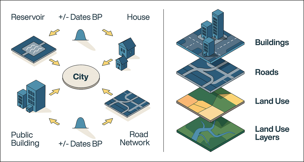
Advances in archaeological urban theory emphasise dynamic, bottom-up processes (Raja & Sindbæk Reference Raja and Sindbæk2020; Leadbetter Reference Leadbetter2021; Smith Reference Smith2023) and this is reflected in URBank’s data model. Each city is represented as the centre of a web of connected elements—for example, infrastructure, land use and chronological data (Figure 1). In network terms, this is a graph: a set of points (nodes) and their connections (edges). This design accommodates urban complexity and allows researchers to interrogate the very concept of ‘the city’ by analysing the relations from which it arises. It also enables operationalisation of diverse city definitions, facilitating comparative analyses without re-collection of data.
URBank Data Concept: cities are represented as abstract nodes at the centre of a graph with other nodes representing varied associated spatial and temporal data (left panel). This graph representation can be translated into GIS data layers for spatial analyses (right panel) (figure by Hans Sell).

Figure 1 Long description
The left panel of the diagram depicts cities as abstract nodes at the center of a graph, with other nodes representing varied associated spatial and temporal data. Arrows connect these nodes to the central city node, indicating relationships. The right panel translates this graph representation into GIS data layers for spatial analyses, showing buildings, roads, land use, and land use layers stacked vertically. Each layer is labeled accordingly, demonstrating how urban data can be organized and analyzed spatially.
URBank is a platform for addressing fundamental questions about ancient cities. Many of the most important advances in urban archaeology, from identifying scaling laws (Ortman & Coffey Reference Ortman and Coffey2017) to comparing political economies across regions (Drennan & Peterson Reference Drennan, Peterson and Smith2012), derive from the compilation of small, often messy datasets. Important, theoretical and policy-relevant questions—such as, do ancient cities exhibit agglomeration economies comparable to those in modern systems? Or, how do population densities and spatial layouts differ between urban traditions, and what do those differences reveal about their political and economic organisation?—can be tackled rigorously with the kind of systematic aggregation URBank enables. By establishing common standards for metadata and coding, URBank turns scattered, one-off datasets into a versatile, cumulative resource.
Open FAIR science
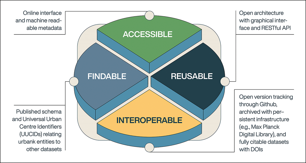
URBank is committed to Open Science and FAIR principles (Wilkinson et al. Reference Wilkinson2016) (Figure 2). The database schema and metadata are published in machine-readable formats, and records have persistent, unique identifiers, including a digital object identifier (DOI) and universal urban centre identifier (UUCID) (Figure 3). Versioned snapshots of the database are archived upon the finalisation of new entries.
The FAIR principles upon which URBank is built (figure by Hans Sell).

Figure 2 Long description
The pie chart illustrates the FAIR principles for URBank, divided into four equal segments. Each segment is labeled with a key principle: Accessible, Findable, Reusable, and Interoperable. The Accessible segment is highlighted with a green color and is associated with an online interface and machine-readable metadata. The Findable segment is blue and relates to published schema and Universal Urban Centre Identifiers (UUCIDs) that connect urban entities to other datasets. The Reusable segment is dark blue and emphasizes an open architecture with a graphical interface and RESTful API. The Interoperable segment is yellow and involves open version tracking through GitHub, archived with persistent infrastructure such as the Max Planck Digital Library, and fully citable datasets with DOIs. Each segment is connected to descriptive text that explains the specific aspects of the principle it represents.
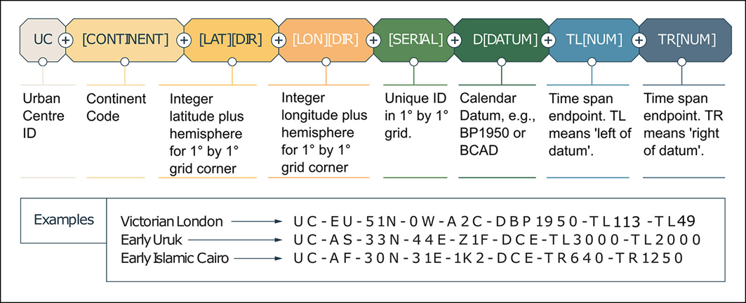
URBank’s UUCID logic (figure by Hans Sell).

Figure 3 Long description
The diagram illustrates the URBanks UUCID logic, showing a sequence of labeled components. It starts with Urban Centre ID, followed by Continent Code, Integer latitude with hemisphere for 1 degree by 1 degree grid corner, Integer longitude with hemisphere for 1 degree by 1 degree grid corner, Unique ID in 1 by 1 grid, Calendar Datum, Time span endpoint left of datum, and Time span endpoint right of datum. Examples provided include Victorian London, Early Uruk, and Early Islamic Cairo with their respective UUCID codes.
URBank also recognises the complicated ethical and legal dimensions surrounding archaeological data. While all data will be accessible to verified partners and institutions, public access is governed by a tiered system. Contributors may mark entries with different levels of access and co-ordinate precision, ensuring compliance with national regulations and community priorities. In cases where restrictions prevent full sharing, URBank maintains UUCIDs as reference records and directs users to responsible institutions or agencies.
Designed to evolve, built to last
URBank is hosted at the Max Planck Institute of Geoanthropology (Jena, Germany) and developed in collaboration with leading urban archaeologists, historians, urban studies scholars and Earth System scientists (https://urbank.earth). Launched in January 2025 by the Department of Coevolution of Land Use and Urbanisation, and founded with partners including Durham University and the University of Colorado Boulder, URBank’s data ontology is already a fundamentally new resource for comparative urban research. It is, however, explicitly designed to evolve and to respond dynamically to new ideas, collaborations and theoretical advances. It serves as a global hub for aggregating and analysing urban data, supported by the Coalition for Archaeological Synthesis (CfAS) and dialogue with international scholars. With hundreds of entries already, URBank is actively being populated by the CfAS Urban Adaptation Working Group (https://www.archsynth.org/project/urban-adaptation-to-environmental-change/).
URBank in action
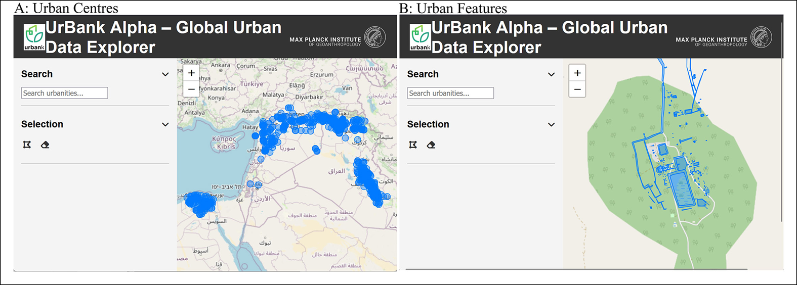
URBank’s advantages are highlighted by two examples. In the first, a low-dimensional dataset of pre-Classical urban centres from South-west Asia and Egypt are represented in the traditional cities-as-points format (Lawrence et al. Reference Lawrence, Hinojosa-Balino and Chelazzi2025) (Figure 4A). Points represent central co-ordinates for settlement mounds, and each location links to a corresponding city construct in the database graph with attributes drawn from spreadsheet columns.
URBank supports a spectrum of data types and visualisations, from ‘city-as-point’ data (panel A, showing pre-Classical urban centres from South-west Asia and Egypt) to ‘city-as-constellation’ data (panel B, showing Koh Ker, Cambodia) (figure by Hans Sell).

Figure 4 Long description
The image consists of two panels labeled A and B. Panel A displays a map with blue shaded areas representing pre-Classical urban centers in South-west Asia and Egypt. Panel B shows a detailed network diagram of Koh Ker, Cambodia, illustrating various urban features connected by lines. The map in Panel A highlights regions with significant urban development, while the network diagram in Panel B depicts the interconnected elements of an urban area, such as infrastructure and land use. These visualizations reflect the dynamic and complex nature of urban centers, emphasizing the relationships and connections that define them. The data model used accommodates urban complexity and allows for comparative analyses without the need for re-collection of data. All values are approximated.
In the second example, rich, multilayered datasets from Koh Ker, Cambodia, briefly the capital of the Angkorian World during the tenth century (Tho et al. Reference Tho, Huon and Moul2016), highlight how URBank can also represent relational urbanism. Koh Ker is a constellation of temples, houses, water infrastructure and land use (Figure 4B). Over time, as the graph of interlinked records grows, it will become possible to evaluate whether constructs like Koh Ker have empirical coherence—whether they correspond to temporally persistent patterns in the lower-level graph of data—indicating that a single, persistent ‘city’ actually existed.
URBank enables the use of both simple ‘city-as-point’ and detailed ‘city-as-constellation’ modalities. The quality of the datasets, rather than database architecture, shapes analytical possibilities.
Outlook
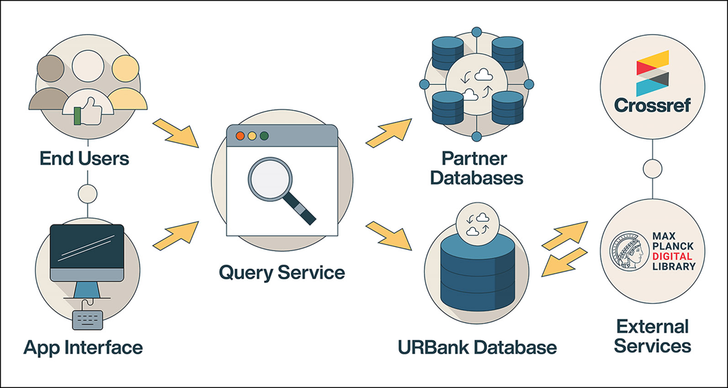
URBank consists of a standalone database and services that integrate partner data, with a layered architecture reflecting this dual purpose (Figure 5). This structure will allow URBank to be a primary analytical resource for the study of global urbanism across human history. The project welcomes contributions and collaborations, developing data structures and theoretical approaches that connect archaeology to contemporary challenges. Researchers interested in linking their urban data to URBank can request an input template from the corresponding author.
URBank’s multilayered architecture (figure by Hans Sell).

Figure 5 Long description
The diagram depicts the multilayered architecture of URBank. It shows end users interacting with an app interface, which connects to a query service. The query service interfaces with partner databases and the URBank database. Additionally, the URBank database interacts with external services such as Crossref and the Max Planck Digital Library.
Acknowledgements
We thank the National Authority of Preah Vihear, the Cambodian government body responsible for managing the Koh Ker World Heritage Site, for granting permission to use Koh Ker to demonstrate the potential of URBank’s data model.
Author Contributions: using CRediT categories
W. Christopher Carleton: Conceptualization-Equal, Writing - original draft-Lead, Writing - review & editing-Equal. Dan Lawrence: Conceptualization-Equal, Data curation-Lead, Writing - review & editing-Supporting. David Brotherson: Writing - review & editing-Supporting. Claire E. Ebert: Conceptualization-Equal, Writing - review & editing-Supporting. José Lobo: Conceptualization-Equal, Writing - review & editing-Supporting. Scott G. Ortman: Conceptualization-Equal, Writing - review & editing-Supporting. Michael E. Smith: Conceptualization-Equal, Writing - review & editing-Supporting. Thon Tho: Data curation-Equal. Iza Romanowska: Conceptualization-Equal, Writing - review & editing-Supporting. Sarah Klassen: Conceptualization-Equal, Writing - review & editing-Supporting. Patrick Roberts: Conceptualization-Lead, Writing - original draft-Equal, Writing - review & editing-Equal.

 Open access